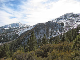
While I have done some minor hikes over the last few weeks at places like Huffaker Hills, I've been aching to actually get to something a little more substantial. I decided to try one of the hikes that starts at the Galena Creek Regional Park. I purposely got a later start, as I wanted to let the sun warm up the day a little bit. I arrived at the visitor center right about noon and asked the gentlemen at the reception desk about the trail conditions at the higher elevations of the Jones Whites Creek Loop. He said that no one had reported back on the conditions recently, but that the Church's Pond trail, which forks off of the Loop at the high point had been reported as being passable three weeks ago.
I decided to risk it and just decide which way to go once I got to that area. I parked the jeep
at the trail head, threw on my pack (which I have additional weight in for training purposes), and headed out. The trail is well maintained as it follows the small Jones Creek. The incline is pretty steady in this early section, with occasional steep piece. After a mile or so of this
steady incline, I was getting a little winded, but I wanted to keep pushing myself, as part of my purpose today is training for more difficult adventures later this year.
In it's steady climb up towards 8k feet, this trail reminds me of a trail that my friend, Brent,
and I hiked last year in Lassen Volcanic National Park. As I proceed up the trail, the incline
goes from steady to fairly relentless. There really is no loss of elevation at all, as I make my
way past a series of three switchbacks. As I near the top, I get a great view of the snow-covered Slide Mountain to my south and the slightly taller and equally snow-covered Mount Rose to my southwest.
Arriving at the high point of the trail, I hit a fork. Left goes another 0.7 miles to Church's
Pond and right continues on the Jones Whites Creek Loop. As I really want to get the miles in, I decided to try the Loop. However after just a few yards, the muddy/snowy step slope encourages me to turn back. I decide to be content with Church's Pond, which will hopefully be less treacherous.
There is snow up here, the facing direction of this slope or that has a great impact on how much sun a patch of ground gets and therefore how much snow remains, but there are several sections, which have two or more feet up here. I slip and slide through the mud and snow, and eventually make my way to a frozen swimming pool size pond at the center of a much larger indention. I suspect the snow melt will vastly increase the volume of this pond in a couple of months. For now though, I'm content to sit on an exposed boulder and eat a granola bar before heading back.


No comments:
Post a Comment