Friday, August 25, 2017

Placer Big Trees (Placer County, California)


The vast majority of the Giant Sequoia exist in groves stretching south from Yosemite National Park to Kings Canyon and Sequoia National Parks. Some months ago, I read of a tiny grove in Placer County, which is by far the northernmost area in which these mighty giants live. I've visited many of the other groves and decided to make the drive "over the hill" from Reno towards Auburn, CA.

The drive to the grove heads about 40 miles east of Auburn, along narrow mountainside roads traversing the giant valleys of the American River, including driving over the tallest bridge in California. A number of sections of Mosquito Ridge road have been partially washed out, presumably by the heavy snows this winter and subsequent melt. 


Finally reaching the trailhead, I embark on a short hike through the woods. A number of large trees occupy this forest. Notably, a gigantic douglas-fir rises near four young sequoia. The fir is significantly larger than any of these young trees, but with luck these toddlers will survive and overtake their neighbor in the centuries to come.

Proceeding deeper into the grove, I come across the local giant, the Pershing Tree. At only 12-feet in diameter this adolescent giant is still quite small by sequoia standards, but it is the patriarch of the grove nonetheless.


Just a short distance further, the trail passes through a cut section of the fallen Roosevelt Tree, which probably dominated this grove prior to its fall in 1861, before heading back uphill towards the trail head. The tiny grove only contains six giant sequoia and though they are all young, they are still impressive. The trail itself is less than a mile long, but any trip to see these mighty giants is worth one's time.

Saturday, August 19, 2017

Roses Knob to Grays Lake (Washoe County, Nevada)


Just a few miles southwest of Reno, Mt. Rose rises to dominate the city's horizon and surrounding it, the Mt. Rose Wilderness offers numerous hiking trails. I've hiked this area quite a bit over the years, but when Deanna's hiking group posted a trip to Roses Knob and Grays Lake within the wilderness area, I wanted to take advantage of trail I had not explored. Besides, I always have a great time with this group.

Meeting at Sierra Summit at 8:30, we caravan-ed up to Tahoe Meadows, found parking, and met up with the remaining group members - 16 of us in all. The trail starts out very easy as it follows a forest service road, but then quickly leaves the road and enters the forest and quickly crosses a fairly sturdy bridge over a small creek. As usual, the group starts to splinter a bit. Everyone here is a strong hiker, but some have a faster pace than others. The group is always good about stopping occasionally and allow everyone to regroup though.

As we hit the junction with the Tahoe Rim Trail, we take a right and head North, as we believe this is the correct direction. Even though it's mid-August, we had so much snow this past winter (record-breaking) that snow-patches still cover some sections of trail, but nothing bad enough to hinder us significantly. After about a mile and a half, we start to question our route and start pulling out the maps. We quickly realize that have taken a wrong turn. We are currently headed north towards Relay Peak, when we should have been heading south towards Roses Knob. We give Walt, who was sort of leading the charge, a good-natured ration of hell and turn around to head back for the junction. He takes it in stride and we all get a good laugh out of it.


Returning to the site of our error, we take the other fork as the trail overlooks a magnificently flowered canyon that opens up into Incline Village and Lake Tahoe below. Though I have lived in this area for several years now, I'm still always in awe of the size and beauty of this jewel of the Sierra Nevada. This vantage point is spectacular for seeing the whole of the lake. 


The trail continues around Roses Knob, a small peak names for it's much larger neighbor to the north. Four of us, who have put some distance between us and the rest of the group decide to wait for the others to catch up. After a couple of minutes, we decide to climb the steep hillside above us and head for the summit. It's a pretty precarious climb that eventually travels over a large boulder field before reaching the top, but we eventually make it. The view is terrific, but knowing the group will be catching up soon, we head back down.

The way down is even more treacherous as we must traverse more boulders - larger ones this time. The boulders themselves aren't the difficult. It's actually the negative spaces between boulders that pose the most danger. We carefully maneuver ourselves across the field and eventually hit the treeline again. With no trail visible, we bushwhack west, knowing that we should cross the trail at some point soon. As we carefully navigate, we hear hear the tell-tale sign of a rattlesnake under a nearby rock or tree. It's only a quick rattle, but taking know chances we go on high alert. Soon, we hear the voices of our group, but a large wall of snow separates us. We make our way around it and soon rejoin some of the group. It turns out that some of the other members had hiked up another side of the peak, which is why they were delayed. It's not matter though, we had agreed to meet at Grays Lake in the valley below.


We make our way for the lake. From above the lake looks like a green meadow, but once at the mouth of the creek running out of the lake its obvious that the lake is just rich with lush grasses, enough so to camouflage it from above. A quick rock hop across the creek and we reach a nice section to rest and wait for the others, who arrive just a few minutes later. We take a few minutes to socialize and eat some lunch. Suddenly, we hear the rumble of thunder in the distance and while the trees mostly obscure our view, we notice some gray clouds moving in. 


Not wanting to be on any peaks when the lightning starts, we quickly put on our packs and start making our way out of the bowl valley. We push our pace pretty hard, but as we cross the feeding creek at the northeastern section of the lake, I have to stop for a shot back at the lake. Strangely, as we cross the ridge back over to the eastern side of the the sun is once again shining and there is no sign of the thunderheads we heard. Ah well, better safe than sorry. We take a few minutes to enjoy snacks, cold beer, and each others company at the trailhead before parting ways. As always, it was a terrific time with some terrific people. With our 'detour' at the beginning, we put in a total of about 10.2 miles with some good elevation gain. 

Sunday, August 13, 2017

Reno 10-Miler (Washoe County, Nevada)


The Race178 organization is responsible for a number of races in and around the Reno/Tahoe region, including the Reno-Tahoe Odyssey. Having run a number of their events over the past couple of years, I know what a terrific job they do of putting them together. This morning the Reno 10-miler will take a couple thousand of us through downtown, in and around the UNR campus, and finally along the Truckee River before reaching the finish line.

Unfortunately, I got a bit of a late start at the gun. The limited number of portable restrooms created a long waiting line and I arrived at the starting line a minute or two after the main crowd had taken off. I was not the only one though. Apparently, several of us were slightly tardy. The Reno PD does an outstanding job of blocking off traffic and ensuring the runner's safety along the long weaving course.

As we leave the start alongside Wingfield Park, the route heads north on Virginia Street through the heart of downtown before taking a right turn followed by a quick left and into the UNR campus. I'm feeling good this morning, but as I have not been training very much since the RTO in June, I decide to take it easy on the uphill sections. We make a trip around the quad before heading into the stadium for a single lap around the track. After another trip through the quad, we return to downtown and head west.

The trail crosses over Interstate 80 and then through the residential areas on our way to Idlewild Park. From here the course follows a familiar route that many of the local races use, which takes us along the Truckee River and back to the finish line near Wingfield Park.


As I approach the finish line, I call on my reserves and finish strong. As a volunteer places a finisher's medal around my neck, I hear a group of people calling my name. Several of my teammates from my RTO team had finished just ahead of me and ask me to join them for a picture. How can I resist such a good looking group of ladies.

After the picture, I grab some water and head over to my buddy Bret's tent to help him pour some delicious brews for our fellow finisher's.


Friday, August 11, 2017

Perseids on the Playa 2017 (Pershing County, Nevada)

 Photo courtesy of the Friends of Black Rock

Last year, I decided to camp on the lifeless playa of the Black Rock Desert to get an unpolluted view of the annual Perseid Meteor Shower, which peaks around the second week of August. I had such a fantastic time, I decided to do it again this year. My hiking buddy, Bill, decided to join me this year.

Leaving right after work on Friday night, we took Bill's jeep the 100-ish miles from Reno to the campsite coordinates provided by the Friends of Black Rock organization. While one can camp nearly anywhere on the playa, the organization sets up a nice camp complete with portable toilets and it's always nice to meet and mingle with fellow campers. This year though with the extraordinary amounts of precipitation we received in the winter and spring, some parts of the playa are still either covered with water or the white mud that it turns the ground into. The organization found a good dry spot and I'm happy to take advantage of their scouting and generosity.

Arriving right around dusk, Bill and I quickly put our respective tents up and begin to get situated for the show. Unlike last year when I went to bed early and rose about 2:00 AM at moon set, the bright moon was scheduled to rise around 10:30 PM and so, the best viewing will be before and just after that time. In preparation for the assault of falling stars, we have a few beers and wait for the show.


As the sky changes from blue to orange to absolute pitch black, the sky transforms into a shooting gallery. It's difficult to catch them all because they blink into and out of view so very quickly. If you don't happen to be looking in the right direction at a given moment, you will not be quick enough to spin to see it when someone calls one out. That said though, we are able to spot probably around forty before the moonlight becomes a problem. The most interesting ones are presumably very close overhead, as we can occasionally see the steam trail in their wake. Finally, with both of us pretty tired, we turn in for the night, but what a great show it was.

Sunday, August 6, 2017

Columns of the Giants (Tuolumne County, California)


On the drive home from Yosemite, Bill and I decided to take a short detour across Sonora Pass to see the geologic wonder known as the Columns of the Giants, which is an excellent example of a columnar basalt formation. I have visited the site on a couple of previous trips, but it's interesting enough to visit again.


From the paved trail head, a short paved trail crosses the middle fork of the Stanislaus River over a sturdy bridge. As with all other waterways in the Sierras this year, the river is raging below us. Above us, we can see the near edge of the basalt cliff with the telltale lines of the columnar formations, which are a result of volcanic lava flows and rapid cooling.


At the end of the trail, only half-a-mile or so further in, the cliff has crumbled into enormous piles of hexagonal boulders, which ones formed columns identical to the ones that remain part of the cliff above. We notice some adventurers who have scrambled up the pile to reach a small overhang in the cliff above and while Bill and I are curious, we still have a long drive home and decide to head back to the jeep.

Saturday, August 5, 2017

Mono Pass (Yosemite National Park, California)


The second hike of the day was up to Mono Pass, which I have been reading about and passing the trailhead of for many years. Finally, today, I would hike this route into the mountains. The trailhead is nearly full, which is a bit surprising given the cloudy sky above and the forecast for rain. It doesn't deter Bill and I though.

We hit the trail and are almost immediately faced with a tough creek crossing. The record snow fall in the Sierra Nevada this year is still melting and likely will continue through the summer until the fall snows begin to rain down and the cycle restarts. Bill balances his way across a skinny fallen tree, no more than 4 inches in diameter. I feel less sure-footed on such a slippery and tiny log than Bill does and I so, I being to look for another way across. Walking a few yards upstream, first consider throwing some large rocks in to the rushing creek to act as stepping stones, but the water is too deep for this to be very effective. I finally decide to getting a running start and jump across, a distance of about five feet. I make the crossing without incident and rejoin Bill on the other side.


The trail passes through alternating terrains of meadow and forest as it heads southeast towards the high mountain pass. In the distance, the tall snow-covered mountains of the High Sierra loom overhead. Almost immediately after hitting the fork that leads to Spillway Lake, the grade of the trail increases drastically and becomes quite a workout. 

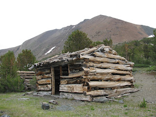
As it twists and turns through forested hillside and around the contours of the mountainside, we pass a couple of ruined cabins. The men and women that lived here were surely made of the toughest stuff there is. I can't even imagine wintering at this high altitude. Here, above 10k feet elevation, the winters are hard and last for a very long time.


Just after passing the second cabin, the trail opens up into an enormous meadow and on the far side of the small creek that cuts through its center, we spot a couple of deer grabbing their lunch from the lush greenery. A few other hikers are in this section, but not many. It's very peaceful up here so close to the heavens and the lack of crowds makes it all the more divine. Those few souls that do dare travel into this backcountry have earned it. They are my kind of people.


Skirting the meadow, we take a side trail that one of the hikers tells about, which leads to more of the long-abandoned cabins. After passing through a soft marsh and past a couple of small lakes, we reach a series of log cabins in ruins. In total, there are four cabins grouped closely together. We exam them and as we start to talk about what would inspire people to live up here (beyond our own since of adventure), we assume there is mine-shaft nearby.


Searching around the tundra complex, we eventually find another structure that I first thing is a cabin, but soon realize is the abandoned mine-shaft. The timbers of the structure have collapsed and fallen into the mine, but it is of little concern as the shaft is completely flooded. It seems likely that the miners dug to deeply and eventually hit a underground spring, putting a quick end to their get-rich scheme. A few yards away, we find the vent shaft, also filled with water. To have come so far and worked so hard, as these miners must have to survive in this high-elevation settlement, only to see their dreams flooded by the very mountain they were seeking riches from must have been heartbreaking.


Rejoining the original trail, we take note of the darkening skies and expect rain drops to start falling any time. However, we decide to make a final push for the actual pass and a view of the ancient Mono Lake beyond. As we pass beyond the park boundary, the sky begins to open and a few drops of rain strike the trail. Just a half mile so further, we finally reach the high point of the pass and take in the view of the giant lake beyond. Fires in the region have filled the skies over the lake with smoke, making it difficult to see, but the shape and size of the lake are unmistakable. 

From this point, we are in a race against the clock and skies to reach the trailhead before all hell breaks loose and we are caught in a downpour. Bill and I both have some rain gear with us, but with four-plus miles to the trailhead, there really isn't any type of gear that could keep us dry. 


We both race down the trail, doing more of a trail run than a hike at this point. Bill, true to his nickname 'Downhill Bill' sprints a good section, while I maintain a steady 10-min mile pace. The impact of the downhills steps at this pace really tear my old knees up and I try my best to maintain. When I catch up to Bill a short time later, he is watch a group of three large bucks pass in front of him. I only see two of the three, but they are truly magnificent. 

As we arrive back at the creek-crossing, Bill quickly scrambles across the same fallen tree as before. I reluctantly follow-suit and uneasily balance my way across the log. As I reach the other side, I cut my hand on a nearby limb. Nothing serious, but enough to annoy me. With only a half-mile or so to go, we run out the last of the trail as the rain picks up into a steady shower. 

Arriving back a the trailhead, I take a minute to clean and dress my cut, before removing my pack and putting everything back in the jeep. The hike is listed as 8-miles, but with the side trips and additional distance for the view of Mono Lake, we ended up putting in nearly 10 miles, with the return trip being completed in just over an hour. The hike was really interesting, especially the miner's cabins and I would recommend this to anyone visiting the park.

Lembert Dome (Yosemite National Park, California)


Upon entering Yosemite National Park from the east, the first granite dome one encounters is Lembert Dome, whose's southern slope is only a few dozen yards from the highway. For many years and over numerous trips to the park, I have passed this granite behemoth with little fanfare, but finally I decided it was time to hike giant rock. 

My friend Bill and I drove to the park Friday evening and camped in Tuolumne Meadows Campground. We awoke early Saturday morning with a few hikes in mind for our agenda. Lembert Dome was first on the list. We quickly got ready and headed for the trail head, knowing that it fill sup fast.


The first part of the trail isn't really a trail, but simply traverses the sloping granite slab. As far as granite slab goes, this is a really large one, but in the sea of granite that is Yosemite, it's only a minor example. The 'trail', such as it is, continues to skirt the edge of the granite and enters a section of trees with CA 120 just feet below us. We scramble over logs and and loose boulders as we make our way around to the backside of the dome. At times, the climb is relentless, but eventually , we reach the ridge on the far side of the dome and while Bill takes a breather, I scramble up the granite and to see how far I can climb up.


A long granite spine, with drop offs on either side, leads to a tall and steep mini-dome. The view from up here is amazing and I can scan the majority of the high country of Yosemite. While I would probably be able to climb a bit and make my way around this section, the risk just didn't seem worth it and so, I head back down to Bill. 

We make our way through the forest and eventually trail/road to the trail head. Only a couple of miles on this one, but the steep grade at parts made for a really good workout.