Forever on the lookout for new and interesting trails, I stumbled across Black Shoals Park while scanning some nearby trails on the internet. It's relatively close to my home and seems like it might be something of a hidden gem since I've never heard of anyone talking about it. A chilly spring morning before attending a lager festival seemed like the perfect opportunity to explore this new trail.
After the short drive to the park, I pulled up to the attendant's booth. I wasn't aware from my reading that the park charged any entrance fees and after chatting with the nice lady working the booth, I discovered that fees are only charged for launching boats from the park. Access to the hiking trail is free to the public. After getting my bearings and finding a parking spot, I quickly hit the trial, which initially dives into a wooded area above the lake and proceeds up a mildly steep incline.
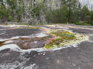
It's early and no one else is here yet, which is nice. After a short distance through the wooded section, the trail empties out onto a large granite monadnock, similar to many others in the area. Here, the recent rains wash over the granite in small streams and pool up in areas before eventually reaching the creek and lake below. The flora here is almost identical to what one finds on the nearby Arabia and Panola mountains. The white blooms of diamorpha smallii extend skyward from the red foliage, never reaching beyond a couple inches out of the granite. There are huge patches of this endangered plant here. It makes me hopeful that it remains relatively unknown to the masses.
At the edges of the granite, large patches of bright yellow daffodils provide a contrast to the red smallii and complete the beautiful palate, along with the greenish-gray lichens. It's a wonderful visual. As I make my way along, I try my best to avoid damaging any of the plant life, but I see others have had less care. A couple of quad-runner tracks have trampled through a patch of smallii, perhaps further hurting the species chance for survival. The trail it self is marked with white paint lines on the granite, but they have either mostly faded or been grown over by lichens. The trail also seems to split in many sections and I take advantage of some of these spurs to follow the granite all the way down to the man-made lake, where it plunges below the murky waters.
On the far side of the lake, I can see where the granite track re-emerges from the water and continues northward. After looking at a satellite view of the area, I can see that the granite extends like a long line running north and south for quite some distance. This area must have been something to see when the geologic forces that created it were at work.
Eventually reaching the road, I consider walking a bit further to the covered bridge mentioned in the description and which I drove over to get to the park, but with the prospect of road-walking being less than appealing, I decide to turn back and return to my car. After traversing around a few mud puddles along my route, I reach the parking lot and check my distance, which is showing up at right about 2.6 miles. This was just a short little hike, but the rich flora and geology made it well worth the time.


No comments:
Post a Comment