While I have visited this amazing petroglyph site before several years ago, that trip was via 4x4. I recently joined the Reno Hiking Meet-up group and received an email stating the group would be hiking to this desert site. I have often considered returning and this seemed like an excellent opportunity both to revisit the site as well as take my first trip with the group. Arriving at the agreed upon location, we car pooled to the trial head deep in the Lockwood area and started our trek. From what I understand from the organizer today's group is uncommonly large (24 hikers), but each and everyone of them were incredibly welcoming.

The trail starts up the bed of Long Valley Creek and follows it for about five miles. While the group attempted to follow a uniform and established route, it was often a matter of path finding as we zig-zagged back and forth across the creek looking for firm footing. I have to say that it was actually pretty refreshing to not have a well defined route. I was also surprised to find water in the creek this time of year after such a dry summer. I was informed that the creek is fed by a number of springs. Obviously, the local wild mustangs are aware of this as we encountered several of them along the journey.


I'm always amazed at how docile mustangs are. While they are feral, they generally encounter humans enough to not be terribly skittish around us. They are out here just trying to scrap a living off of the land, just as we would do. Unfortunately and as witnessed by the many carcasses we stumble across on the trail, this sometimes proves futile. The desert just isn't a hospitable place during these years of drought.
The group seems to be progressing pretty well, though there are definitely different levels of experience, as many of us push the pace to a point where the group fragments. The organizer, Mel, does a great job of trying to keep track of everyone and ensure no one gets lost. As we cross the creek at an especially problematic section, one of the ladies with the group looses her grip on the stone steps and falls into the mucky water. Two other gentlemen and I do our best to help her out of the water. Luckily, only her pride was injured.
Mel tells us that we should be looking for a set of power lines and an abandoned red car, which are the prime indicators of the site's location. Seeing the power lines in the distance, those of us leading the pack realize we are close and begin looking for what remains of a old red junker (though it has faded from red to pink over the decades). At the site of it, we take a sharp left turn and begin making our way up a rough 4x4 road to the petroglyph site.

The site is much as I remember it. Isolated and home to the one of, if not the, largest collections of ancient Native American petroglyphs in the state. According to documentation I have seen, the site contains approximately 2200 designs, most of which date to around 10,000 years ago. As I always do when viewing petroglyphs, I can't help but wonder about the artists that created them. What were they thinking? Who were they? And, why did they need to leave their mark on the world? I suspect their reasoning is no different than our answers to those same questions. Still, seeing art created so long ago and by a people, we know next to nothing about is quite humbling.

I spend a few minutes scrambling over the talus boulders and taking pictures, eventually making my way to the top of the ridge. the plateau above the canyon is as barren as any I have every seen in the Nevada desert. Why was this spot so special for the ancient inhabitants. While it could have been the creek below, the much larger (though still small by my standards) Truckee river is only a few miles away. We may never know, but it certainly allows us to ponder time immortal.

Many of the slower hikers are just arriving, as a few of us finish our snacks and explorations. I relax for a bit and share tales of the trails I have traveled, until a couple of gents decide they are going to head back in advance of the group. As I have plans for this evening, I ask if they would mind giving me a ride back to my jeep, to which they generously agree. We double-time it back to the trailhead, stumbling and loosing the trail a few times along the way. Eventually, we arrive at the parking lot and the Kens take me back to my jeep. Overall, a very pleasant 11.5 mile hike and overall experience. It's wonderful that so many like-minded hikers have taken to organizing trips like this. I hope to do more trips with the group in the future..
I have not yet been to Hawaii (it's on my list), but I have to imagine it is more lush and inviting than the lake in Desolation Wilderness named in the spirit of the Hawaiians. For a couple of weeks, I have been hoping to complete this hike, but the weather has not been kind. The Sierra Nevadas have received a combination of rain and snow the last two weekends. Today though, the skies were clear and presented a marvelous day to hike into the wild country southwest of Lake Tahoe.
The trailhead was a bit difficult to find, but after talking to a couple of friendly people, I finally found it at the foot of Lower Echo Lake. While this large body of water is extremely beautiful, it somewhat spoiled by the presence of cabins all along its shoreline. I guess if we coudl afford it, my wife and I might buy a cabin up here as well. For now though, I will have to settle for simply hiking through.
The trail is somewhat rugged and is comprised mostly of small granite rocks, with an occasional patch of dirt. While the trail is mostly level it does make a slow ascent up into the mountainous areas of the wilderness. Passing Lower Echo Lake, it's companion, the smaller Upper Echo Lake comes into view. similar in shape, but only about half the size, this lake has much less development around it. The lower lake only has boat access to the cabins and with the upper lake being slightly more remote, it makes sense that fewer people would have built here.
Finally, as I make my way around the upper lake, I pass a sign indicating that I have entered the Desolation Wilderness. Thankfully, this areas federal designation as a wilderness area prevents any development beyond this boundry. It's all wilderness from here on out. The trail continues through a wooded area that has a wonderful autumn display of colors in progress. The combination of desiduious and evergreens makes for a wonderful palate of rich colors. Passing a sign indicating which trail leads where, I elect to take a detour to the Lake of the Woods. From an article I read about this hike, this alternate route will be well worth it.

Heading down a number of swichbacks, I make my way down into a small valley to what is perhaps the most beautiful alpine lake I have seen. Lake of the Woods is a peaceful and serene jewel in this wilderness. Deep clear water gives a clear view of fallen trees and boulders on the bottom. There are even some tiny white sand (pulverized graine) beaches along this section of the lakes shoreline. I take numerous shots of this amazing place. If I were prepared to camp tonight, this would be where I would stay. As I prepare to leave a family of adolescent ducklings paddle across the calm water of the lake. Alas, it's time to move on.

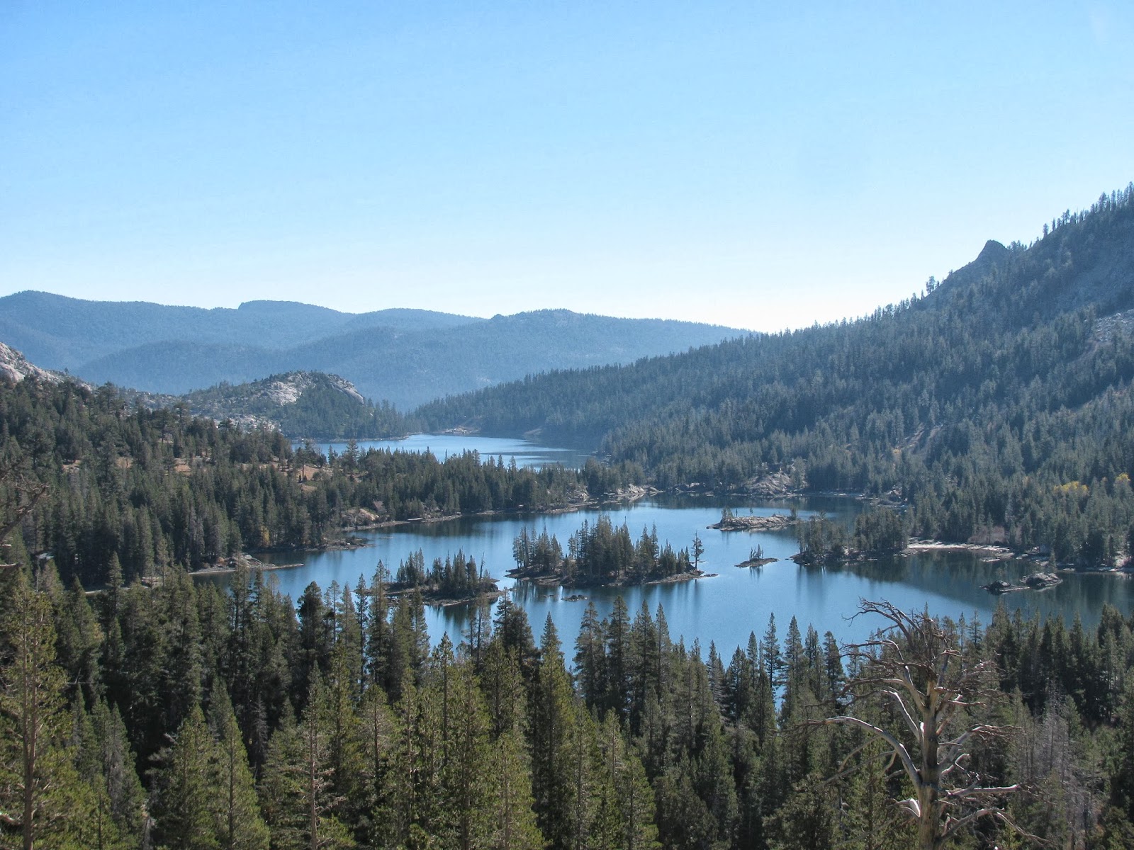
Having rounded a good section of the little lake, I attempt to refind the trail, but fail to see any sign of human footfalls . . . awesome! Eventually, I decide to attempt a little trailblazing. I know that Lake Aloha is just above a rise to the Northwest and so I attempt to scramble over some boulders to get there. A small peak, which I have christened Road Block Peak, will have none of it. It prevents me from this path with tall granite boulders that I am ill-prepared to climb over. Eventually, I admit defeat to the tiny granite mount and double-back. I finally find the trail leading around the other side of the road block and make my way to Lake Aloha.

I'm suprised to see that Lake Aloha is actually a collection of interconnected pools covering an area the size of a couple of football fields. The pools are interrupted by the large granite islands throughout the area. I suspect that in the spring, when the snow has melted, the total area of the lake is much greater than it is this time of year. It is made obvious by the appearance of large patches of low earth, saturated with water, but lacking anything on the surface to be called a pool or lake. The fact that this "lake" exists in Desolation Wilderness is fitting, as this area has very little life. Tree's spotting the area and the islands dispersed throughout the lake are more often dead than alive, and from what I can see, the nearly clear water is free of any fish. I call this place lifeless, but that doesn't mean that it doesn't have a beauty of its own. It truly does and I wish I could spend more time here, but unfortunately, I need to get back.

I take a few minutes to eat a snack (cliff bar, almonds, and some beef jerky) and then start the long trail back to my jeep. Clocking in at just under 14 miles, this was a great hike. I hope to do it again when I can take advantage of warmer weather and take a dip in the lakes.