I decided to join my friend, Nick, this weekend on a camping trip, which was mostly focused around his interest in astro-photography. We had been watching the weather and expected cloud cover all week around the region, and when our departure Saturday morning finally came, we decided to head north towards the Oregon border and camp in the Sheldon National Antelope Refuge. The area is extremely remote and should be about as free from light solution as anywhere in the lower forty-eight.
It's about a four hour drive from Reno through some of the most unpopulated areas of the state, with which we arrived around 2:30. Along the way, we stop a few times to explore some interesting geography that we find along the way. Eventually, we notice a large canyon to the north of the highway and decide to hike out to it. We had noticed an area on the brochure's map called Kinney Camp, which should be nearby, but not having any background on it, we simply made our way towards the canyon.
The first three-quarters of a mile follow a seldom-used dirt road. The high desert has begun to reclaim it, starting with a number of golden grasses, many of which have burr-style seeds that start collecting on our socks and shoes.
As we round a small bend and I find a rock on which to relieve myself, we come across the ruins of the Kinney Camp. While not visible from the road, the remains are pretty extensive and consist of a primitive fenced area and several buildings, including one large one that likely served as the residence. From inspection, this would seem to have been a ranch from around the 1920's, which I later confirm based upon loose information available on the internet. We take a while to explore the various buildings, but very little remains. The local fauna has taken over and built nests in most of the structures. Its always kind of fun stumbling across old ruins like these and imagining how rugged the people living in this area must have been.
After spending a little time wandering around the ranch, we decide to push onward to the canyon beyond. Here those grasses are even thicker and the road appears to not have been used in many years. I've dealt with seed spurs in my socks before, but this is on a different level. With no exaggeration, I would estimate that there are more than a thousand of the prickly little things stabbing me at present. Thanks to some thick socks, I only occasionally have to remove one, but the thick layer of seeds is going to require a lot of time to remove later. For now, there's not point in removing them as they would be back after just a few minutes in these grasses.

Eventually, the road vanishes and we are forced to continue into the canyon off trail. The canyon here is about thirty yards across and is flanked on either side by tall vertical stone walls stretching approximately a hundred and fifty feet above the dry creek at the base of the canyon. As we push our way through the thick sage brush and scramble over several areas of large boulders, we encounter some interesting geology, including several pieces of petrified wood and other rocks with opal deposits clearly visible. This area is famous for opals, but everything we find is encased in rock. Besides, it wouldn't be very un-Leave No Trace like to take the semi-precious stones.
Luckily, we begin to see signs of wild trails. The grasses are laid over where the horses probably bedded down on some recent evening. We do our best to follow the path these mustangs used to traverse the canyon. Above, I we see a number of hawks flying overhead. Their screeches echo through the canyon and it's almost like something out of an old western movie.
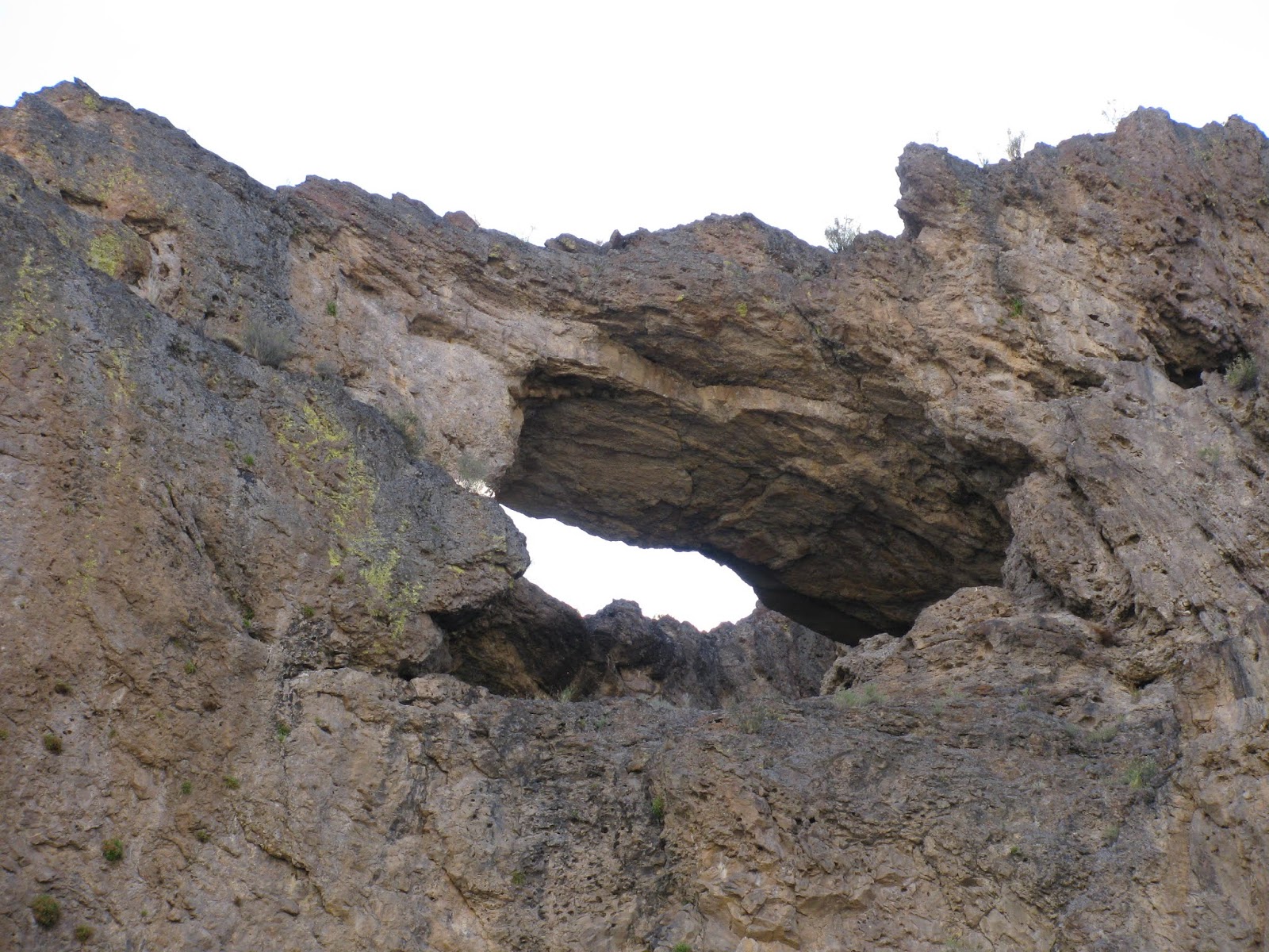
While staring at the avians above us, Nick notices a natural arch in at the top of the canyon wall. It's always amazing to find such wonders out here in the back country and it is one of the reasons I love being out here so much. Being off-trail just adds another layer to the adventure. We continue around a couple of bends in the canyon, but eventually decide that we need to turn back. It's getting late in the afternoon and we still need to get a few miles further to the campground.
As we arrive back at the car, I check to find that we have hiked almost exactly four miles on this little exploration. I start trying to pull the burrs from my socks, but soon realize the futility of the exercise. These socks will have to be tossed. We drive a few miles down the highway and set up camp at the Big Spring Reservoir which is now completely dry. Later I learn that the spring the feeds this lake is also responsible for the creek that runs through the canyon we explored. Also completely dry right now, I assume the name of the canyon is the Big Spring Canyon. As the darkness overwhelms the light, I drift off into a restful slumber.
The Rubicon Trail, not to be confused with the Rubicon OHV Trail, runs around Emerald Bay and a few miles up the western side of Lake Tahoe to the D.L. Bliss State Park. In my opinion and that of many others, this is some of the most beautiful shoreline of Tahoe. Emerald Bay, home to the massive alpine lake's only island, is the jewel of Lake Tahoe. So much so, that Vikingsholm was built as a summer retreat for some of the lakes wealthier past residents.
I've traveled this trail twice in the past. Once about four years ago with friends in the spring, but it started raining on us a little more than halfway to the end point and we turned back. My second tour on the trail was as the part of the course for the Emerald Bay Trail Run the following year. This was a truly challenging course for me to run. I wasn't in the greatest shape and the elevation changes are beastly at points along the trail (at least in terms of running). With that said though, I decided to give the Rubicon Trail another go and take time to breath in the amazing landscape that is this part of the lake.

The drive to Emerald Bay State Park and the Vikingsholm parking lot is a bit more than an hour from my home, and I arrived around 9:30 AM. After some struggles with the automated parking fee kiosk, I finally made my way the mile or so down the popular, but steep trail to the main area of the park, which also signifies the start of the Rubicon Trail. As this is a set of switchbacks traversing a steep drop off into the lake, there are a number of waterfalls to pass by, which always makes it enjoyable.
Arriving at the bottom, I find the restroom before heading northeast on the trail. It quickly departs the popular section of the park and enters a boat-accessible campground popular among locals. The campground is fully furnished with bear lockers and fire rings, and is generally booked during its entire season by those wishing to anchor in Emerald Bay and enjoy one of the most beautiful places on the planet.

As I make my way to the northern end of the campground, I pass a number of other hikers. Most of them are departing their campsite just to get a few steps in, but some will follow the trail up the shoreline and then back to the camp. Unfortunately, my hiking pace is considerably faster than most of them and I quickly catch up. Every one of them is courteous though when I excuse myself and ask to pass. This is common in my backcountry areas, but many of these people are not really hard-core hikers and are just doing it because they saw the trail and thought it would be cool to hike along Tahoe's shoreline.
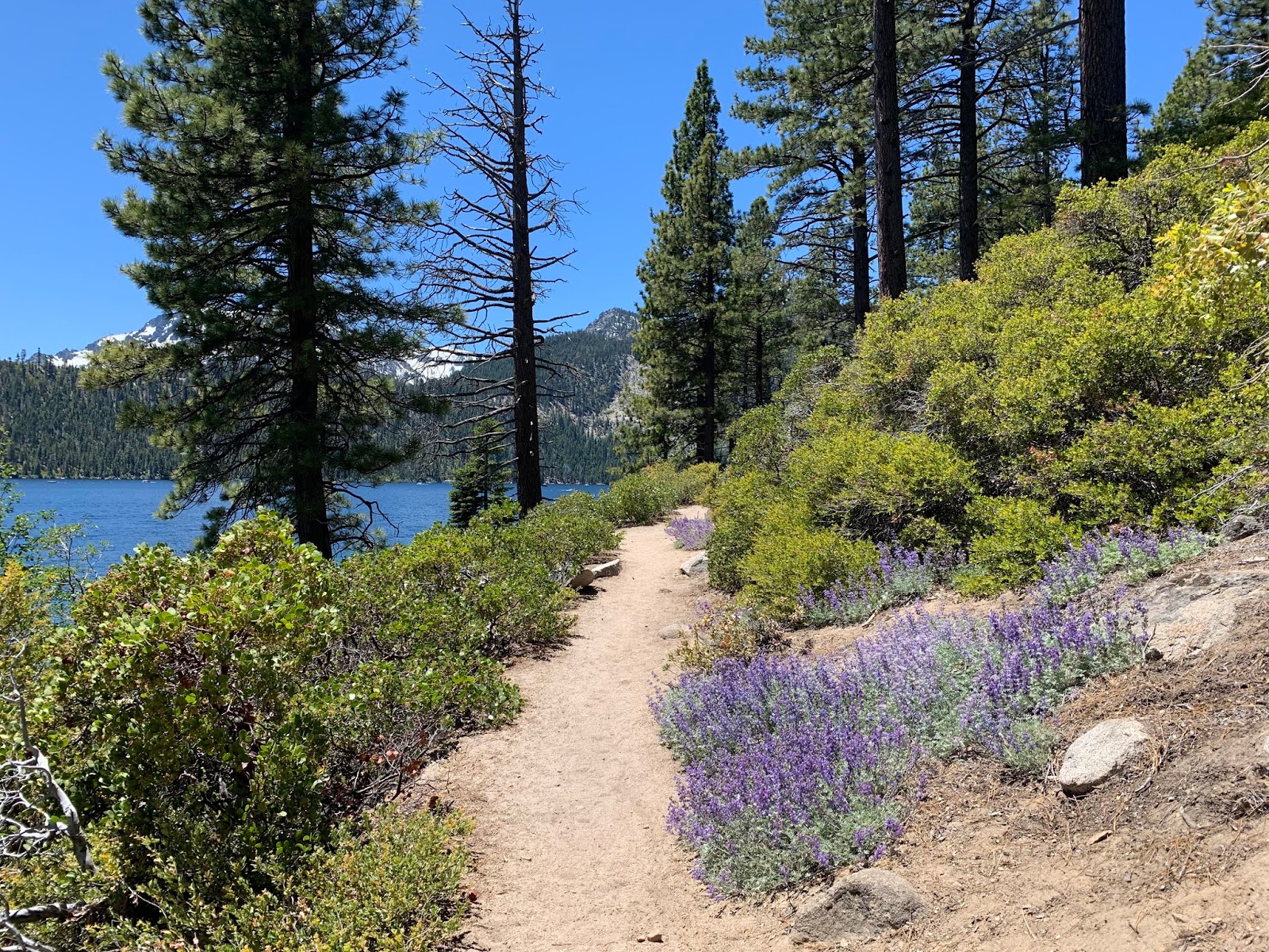
Leaving Emerald Bay, the trail crosses over a small peninsula that makes up the northern guard rail of the bay. I loose site of the lake through this section, but in it's place, I make my way through beautiful alpine forests. At these elevations (6k-ish feet) the snow has all melted for the year, but some of the white fluff is still visible on distant peaks.
Soon, the trail returns to the lake and rewards the traveler with crystal clear blue hues in both the lake and the sky above. Both are occasionally interrupted by the occasional granite boulder (lake) and cloud (sky). The pictures from this place are highly regarded as some of the best anywhere and I completely agree. I can't count the number of friends that have these exact landscapes hanging on the walls of their homes, be it something the purchased or their own photographic fruits.

Finally, I reach D.L. Bliss State Park and head for the small cove below. Here, I make my way out onto a granite perch overlooking looking the lake, which is approximately fifty feet below me. I find boulders at just the proper angle to recline myself and enjoy a small snack and some water. Looking out on a view like this, makes one remember just how good life is and how luck we all are. I really do appreciate having lived here in this area for so long and being able to explore this divine landscapes. In the distance, I hear music and even conversations. I had forgotten how far sound carries over the lake water. Two people just having a casual conversation on the lake a couple of hundred yards away can be pretty clearly heard from this vantage point . . . and I suffer from some minor hearing loss.
After a short rest, I start the return trip, following the trail back the way I came. I encounter even more hikers this time, but it's not surprising given it is the middle of the day. Finally, returning up the Vikingsholm trail to my jeep, see I've logged just over 10.8 miles. Not a bad day at all and considering the majestic scenery, I really can't think of any place better to have spent it.
I've been running a lot this year and I only recently decided to join my friend, Chris, in running my 4th consecutive Rock Tahoe Half-Marathon. He is a lot faster than me and had accepted a position as the official 1:30 pacer. For me, I was just hopeful of beating my best time on this course, which was about 2:18 from four years ago. Either way though, it promises to be a great time.
Chris and I headed up to the lake Friday afternoon and got checked into our hotel. Bib pickup is as the finish line in front of the Hard Rock Hotel and Casino, which is about three miles from our hotel. After dropping off our gear, we drove back down to the casino to get our bibs and shirts. Upon arriving, we almost immediately bumped into other runner friends that were also going to join the fun tomorrow morning. Chris and I had intended to just grab something akin to subway sandwiches for dinner, but our friends talked us into joining a large group for a high-end Italian dinner at a restaurant just a half-mile or so from the Hard Rock. It was an unexpected pleasure to meet and dine with so many good people, and enjoy some of the best Italian I've ever had. After returning to our hotel, Chris and I quick crashed in preparation for our early morning departure.
There really isn't any parking at the starting line, which is near Spooner Summit, and so the race provides shuttles (school buses). Chris and I quickly get ready, drive to the casino, and hop on our the bus for our thirteen mile ride north to the race starting line. As we arrive and unload off the bus, I'm amazed at how warm it is. We're standing at an elevation of about 7k' and it's about fifty-five degrees already at 7:15 AM. In year's past, it has actually been snowing at the start of the race. I'm concerned that today's hotter temperatures might actually be a problem as we drop down into South Lake Tahoe.
I take some time to stretch and go for a short warm-up run, while Chris finds and meets up with a number of his runner friends. I bump into a few friends as well, but Chris has been part of this running community most of his life and I'm still relatively new to it, only having started running about five years ago.
As start time approaches, everyone starts making their way up to towards the starting line. This race is always lively and they have a DJ and master of ceremonies keeping the crowd excited. A local guitarist substitutes for a singer in the performance of the Star Spangled Banner and while I expect a little bit of embellishment, this particular guitarist was not very good and kind of slaughtered the celebrated anthem. I guess that's just the guitarist in me complaining, as the rest of the crowd didn't really seem to notice. And then, with a countdown and a loud-horn, we're off.

The first three miles of this course are always challenging, as we very quickly drop about six hundred feet over the distance. The difficulty comes in when trying to find the right balance between not holding back too much and not letting gravity get carried away. The downhill is always trouble for my aging knees as well. I manage to hold myself to around an 8:00 mile pace for these first three miles, which feels pretty good. Not too fast; not too slow. I wasn't wrong about the heat today. It's tolerable, but pretty hot for a run. I decide to go shirtless for the remainder of the race to help me regulate my body temperature.
After this initial descent, the course begins a series of long undulating waves all the way to the finish line. I do okay for the most part on the uphills, but I'm forced to walk briskly up the steepest couple of them. For sometime, I've been holding pretty steadily with the 2:00 pacer and thinking it would be amazing if I could pull that kind of time off at this race, but with a bathroom break and a few walking stretches, the distance between me and the pacer quickly opens up into an insurmountable distance.
I should be discouraged by loosing the pacer a bit, but I find myself pushing harder and harder. About three miles from the finish line, my problematic right knee begins to cause me issues and I find myself struggling to run through the pain. This knee has been a problem for a long time, but it normally doesn't hurt this bad. I'm guessing the downhill at the start did its work on me. Regardless of the cause, I continue pushing for the finish line.
After making the next to last turn and running alongside the casino parking garage, I call on whatever reserves I have left in my tank and kick in the after burners all the way to the finish line. I cross with an official chip time of 2:14:55, which bests my previous course PR by nearly three minutes. Not bad considering how much my knee is hurting now. One of the volunteers places my finisher's medal around my neck and while catching my breath, I walk over to the beer table for a much-needed and well-deserved ice cold brew.
I've explored the area in and around Pyramid Lake a bit over the years, but one area that I have not visited is a series of sandstone rock formations known to local hikers as the Monkey Condos. When my backpacking plans fell through this weekend, I wanted to find some other outdoor adventures. I saw a meetup post for the area around the Monkey Condos and it seemed like the perfect opportunity.
Meeting up with the three more hikers at a Starbucks in North Reno, we carpooled out towards Pyramid Lake. The hike organizer mentioned that while he had a pretty good idea of the route, there would be some route finding involved. I always like doing a little cross-country and rock scrambling, and so this sounded right up my alley.
We take some jeep trails into the red hills southeast of the giant lake, until we find a place to leave the vehicles a short distance away from Pig Rock, which I visited a couple of years ago. After tossing our packs on, we head further along the road on foot. As we pass Pig Rock, my companions struggle to see the 'pig' until they realize it isn't up on the hills above us, but is the large red boulder right in front of us. It really does resemble a pig and once you see it, it's impossible to miss.
Continuing on down the road, we make our way into the Painted Hills. Eventually, we leave the road and start heading up a dry wash, which heads in a more northerly direction. After a short distance, we are forced to make our way up a steep scree field. It's actually really challenging. With each step we take up the steep hillside, we slide back a few inches. I do my best to find larger rocks that won't move with my weight. My companions take a similar tactic and we eventually reach the top.
From here, we are afforded some amazing views of the surrounding area. To the west, an area of jutting sandstone boulders reminds me of a recent trip to the Fiery Furnace in Arches National Park. The others agree with the comparison. In fact, this entire area is often thought of by local hikers as reminiscent of southern Utah.
At this point, we pause to survey our surroundings and figure out our route. Eventually, we settle on making our way around the backside of the canyon in front of us and up to the far ridge. It takes a bit to get there, but eventually we do. Along the way, we encounter some interesting sites. First, we find what appears to be an exploratory mind shaft. The whole into the red basalt was obviously man-made, but as there is no visible quartz vein, the intention of the wanna-be miner is a bit unclear. Gold and Silver (and all precious metals) tend to be found along large veins of quartz. The absence of such a vein leaves a us a bit confused, but in this remote area, it's unlikely, we'll ever get an answer.

Leaving the shaft and work our way down the other side, we finally find what I'm pretty sure are the Monkey Condos. This natural formation looks like small caves hollowed out from large sandstone pillars. Dozens of such holes are visible in the red stone before us. And while there are no monkeys to be found here in the high desert of northwestern Nevada, one could easily imagine small primates make a home of these 'caves'. It's a pretty striking feature.
Continuing up the next ridge, we decide to stop for some snacks. In the distance, we have an amazing view of Pyramid Lake. From Anaho Island, to the Pyramid, all the way up to the Needles section, the enormous lake sprawls out before us, probably five miles distant. This lake is the terminus of the Truckee River, which is somewhat unique in the world in that its entire purpose is to carry water from one lake to another (Lake Tahoe to Pyramid Lake). The contrast between the blue tones of the lake and the surrounding dessert is stunning.
From here, we make our way down a short distance to Needle Point, which is a basalt formation that juts a eighty or so feet out of the hillside. It's a pretty striking feature, but there is no way I'm going to try to climb up this thing. We admire it for a bit and then work our way around the backside and down towards another jeep trail in the distance.
As we make our away around the winding jeep trails and back towards our starting point, we discuss what a great hike it has been. The route proved to be a bit challenging, especially with all of the scree, but the views were spectacular and with it only being a few miles from Reno, it's been a nice easy day. I check my tracking app once we reach the cars and see that we've hiked about 6.5 miles. We head back to Starbucks to collect the other cars, say our goodbyes, and part ways. It's been an all around good day.