Saturday, November 25, 2017

Round Lake and Bears Lakes (Sierra County, California)


The meetup group scheduled another hike into the Lakes Basin area near Graeagle, CA for today. This trip was to visit a few of the regions many lakes, specifically Round Lake, Big Bear Lake, Little Bear Lake and Cub Lake. Everyone was pretty sure there would be little to no snow on the trail and so most of us left our gaiters and snowshoes behind for the hike.

As normal we met at one of our normal spots and carpooled the hour or so up to the trail head. Sixteen of us in all, spread into five cars made the trip. When we arrived at the trailhead, we were greeted with a few inches of slushy snow in the parking lot - not a good sign. We quickly organize and get moving. 

As we enter the forest, we find a fair amount of snow on the trail. The air temperature is fairly mild and makes the snow pretty slushy in most places, though it has some crunch to it in the shade. Still it's not very deep during this first part of the trail. 


Soon, we pass the first of many frozen ponds as we begin the ascent up to Round Lake. Here the snow begins to get deeper, approaching depths of two to three feet in sections. For the next couple of miles, I should probably change the name of the hike to "Adventures in Post-holing", as one step after the next sees myself and many others sinking deep into the snow. It makes the going incredibly slow and laborious, but we persevere. 

Arriving at Round Lake, the bowl surrounding the lake is covered with more snow, but the contrast of the clear bluish-green water against the white backdrop makes for a beautiful view. As we make our way around the nearside of the lake, I'm wishing I had a pair of hiking poles to use, as the snowbank is slick and the slightest slip of the foot would see one of us sliding twenty feet down into the icy lake waters. Luckily, we traverse the distance without anyone taking a dip.


The going doesn't get much better as we continue around to Silver Lake. Post-holing continues to be the theme of the adventure. We're all enjoying ourselves just hanging out in our beloved outdoors, but the constant sinking into the snow is somewhat frustrating for everyone.

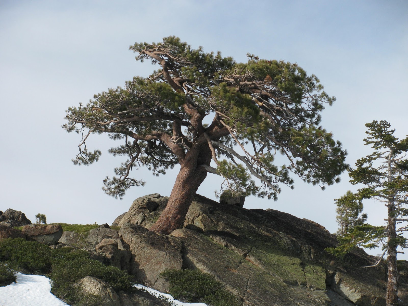
As we make the turn back around to drop down to the Bear Lakes, we note a lone tree on the ridge line. It's growing out of the granite and an angle and we all agree what a great picture it would make.


Arriving at Big Bear Lake, we don't find much relief in the post-holing. Like the other alpine lakes in this area that we have visited, the snow makes for a pristine view. We pass the other two smaller lakes and eventually arrive back a the fork that leads us back to the trail head. This last section is mostly snow-free and it provides some much appreciated relief from the earlier part of the trail. 

In total, we only put in about 4.3 miles today, but the constant post-holing certainly made it a challenging adventure. As usual when doing hikes in this area, the group heads up the road to the Brewers Lair and pulls out a cornucopia of snack food to enjoy with each other while we dip on some good brews and cringe at a barrage of mostly cheesy jokes. I do love this group and I'm glad to be part of it.


Friday, November 24, 2017

Black Hole of Calcutta Falls (Placer County, California)


Three years ago, the outdoor sports giant, REI, started a movement in defiance of the greed and barbarism of the Black Friday tradition of waking up early to rush into stores and shove fellow shoppers out of the way in search of the best deal. REI termed their movement #OptOutside and encouraged would be shoppers to visit the great outdoors on the day after Thanksgiving instead of devolving into proto-humans and fighting each other to save a quarter on a pair of socks that nobody actually wanted in the first place. I've always thought the #OptOutside movement was an exceptional idea and have tried to participate since its inception. 

This year, I decided to visit the Black Hole of Calcutta Falls, which is on the outskirts of the Auburn State Recreational Area. I was going to be in the area anyway and with a name like the 'Black Hole of Calcutta Falls', it has to be a fantastic destination, right? 

Parking the jeep, I note the large number of cars in the area. Perhaps the movement is taking hold. The trail quickly heads out across an old railroad bridge spanning the American River. The trail is well maintained and popular, as I encounter a large number of fellow hikers on my way to the falls.Far below, the American River carves out a beautiful canyon with natural granite slabs lining the banks of the river, much as they do in other areas I have explored like Stevens Trail a few miles to the east.

After just a mile, the trail abruptly drops about 30 feet and a sturdy wooden bridge allows visitors to stand just below the wet black rock that forms the backdrop of Calcutta Falls. The water drops about forty feet from an unseen creek above (probably spring-fed) to a small pool just in front of the bridge. I take a few shots and head back to the way I came. The overall hike was only about 2.2 miles and I would have liked to have done more, but I have a number of other plans this afternoon. At least I was able to #OptOutside a little bit today.

Sunday, November 19, 2017

Coral Cave (Pershing County, Nevada)


For our final site of the day, we return to a series of tufa caves that Nick discovered a few years ago. Located about 5 miles south of Lovelock, NV and a couple of miles north of the much more famous Lovelock Cave, these caves were also formed underwater when this entire area was covered by Lake Lahotan.

After arriving at the coordinates, we drive the jeep off-road a bit and head up the rock outcropping on foot. The entire outcropping is full of caves, some small and some a bit larger. Around the ridge a bit, a deep cave leads 20 or so feet back into the cliff. While it wouldn't be comfortable, it would be large enough to provide some decent shelter for a weary desert traveler. 


Looking above, outcroppings of tufa encrustation are in the process of flaking and crumbling off of the inner rocks. The top of the cliff, some 120 feet above would seem to make a nice perch for raptors searching the desert for easy prey and the graveyard of small mammal and reptile bones at our feet provides evidence of the feast.


As we make our way on around and up the cliff side, we approach the much large cave, the one that Nick named Coral Cave, due to the tufa formations on the roof. The walls of the 'cave' have been scratched with a few petroglyphs and the overhang has protected them from the ravages of time and erosion. Obviously, these caves provided some amount of shelter for ancient travelers.


In the distance, we see another cave and while it appears to be something of a rough hike to get there, we decide to stretch our legs and check it out. Upon arriving, I make the first approach and scramble up a flow of small, sharp loose stones that have crumbled from the cave roof. It's actually a really difficult climb/scramble to get to the cave, but I finally get there without incident. The cave turns out to be nothing more than a large overhang. Interesting, but not worth the effort to get to it. Nick decides to remain below. 

As the sun moves lower in the sky, we decide it's time to head back to Reno. This last site gave us a bit of a workout, but was interesting nonetheless. I look forward to the next trip exploring the bounty of history and nature this desert landscape has to offer.

Lee-Allen Hot Springs (Churchill County, Nevada)


For our second destination, Nick and I head south on US-95 about 15 miles from Fallon, NV. I read of this site in the online copy of a archaeological survey book of Nevada published in the 1950's. As the records are nearly seventy years old, I was a bit concerned about how well the site might be preserved.

The site is just half-a-mile or so off of the highway. A fence guards the boundary of the hot-spring and warns of 180 degree temperatures being expelled from the earth below. The steam rolling off of the water source leave no ambiguity about the meaning of the sign or the danger the area poses. We get some pictures, but don't go beyond the fence.


In addition to the hot spring, the book described a number of tufa boulders nearby, most marked by petroglyphs. The boulders were in plain sight and only a few yards from the spring. We scoured them pretty closely and found some signs of a few pecked rock art figures, but most were in poor condition. I'm not sure if that is centuries causing that the unfortunate defacing by modern visitors.


The final item worth checking out is also mentioned in the write-up. The text describes how one of the tufa boulders had cracked open to form something of a room and how someone in the distant past had patched up the holes between the crack with small rocks essentially making a three walled structure. The structure may have been used as a hunting lodge or even a more permanent dwelling long ago. The structure remains mostly intact, though seems to be inhabited by less civilized desert-inhabitants these days.

Overall, this site is not as well preserved as I had hoped, but it was still worth visiting. Hopefully, our last stop will be noteworthy.

Salt Cave (Churchill County, Nevada)


One of my favorite activities over the past few years is researching and then explore the desert landscape for unique features or ancient Native American rock art. After having learned of a few sites out in the desert between Fallon and Lovelock, I decided today was an ideal day to explore a bit. My friend, Nick, who recently moved back to the area joined me for the adventure.

Our first stop takes us south east of Fallon and across the US Navy's Bombing Range to some tufa caves, referred to in my reading as the Salt Caves. After leaving town and heading out into the desert, we pass a sign warning us to stay on the main roads. As I didn't plan on having any bombs dropped on me today, we follow the guidance. After a couple of miles, we note another sign facing the opposite direction and indicating that we have exited the danger zone.

A dirt road leads off along the ridge, which in millennia past may have formed a shoreline of the ancient Lake Lahotan. After traveling just short distance, we encounter a small cave that looks worth of exploration. The cave shows some signs of carbon build up on the ceiling, but no other signs of human activity. We search the area, but beyond the interesting tufa-encrusted rocks that can be found all over the region, find little else of note.

Driving a bit further towards the coordinates I had mapped at as the likely site of the cave, we note two much large caves in the distance. Like the smaller cave, these two were formed as depressions in the tufa formations when this area was under the lake waters, some 10,000+ years ago.


The first of the two large caves has an entrance about 20 feet tall and 20 feet wide. It bores approximately 100 feet back into the tufa cliff - plenty of room to support a small family. The intense carbon build up on the ceiling and numerous red pictographs on must uncharged surfaces offer testament to the ancient peoples that inhabited this dwelling in the distance past. The pictographs are largely preserved. Hand prints, circles, and other patterns cover the walls, all created with some type of red pigment (blood perhaps).


As we make our way to the second cave, which is only about 50 feet from the first, we note the start differences between the two. This one has a much broader entrance, but lacks the depth of the first. While there are some faded petroglyphs on these walls, the additional sun exposure offered by the larger opening has caused the more rapid deterioration of these examples of rock art.

We get back in the jeep and take off for our next destination. Even if the other two sites on our agenda turn out to be busts, this one made the entire trip worthwhile.

Sunday, November 12, 2017

Monterey Bay Half-Marathon (Monterey County, California)


I've been running half-marathons all year long it seems, but in recent months I have failed to train regularly. A while back, a co-worker mentioned the Monterey Bay Half-Marathon to me and described it as nothing short of amazing. Apparently, the route takes runners right along the ocean for several miles. When I looked at my calendar, I noted that the weekend it was being held, I had no set plans and so, I decided to drive the 5-ish hours from Reno to Monterey to take advantage of this beautiful run.

There were a number of other things I wanted to do this weekend, from wineries to breweries and from hiking to spelunking, I was able to fit just about everything I wanted into this terrific trip. The primary reason for the trip though was to run the half. 


Rising at about 5:30 the morning of the run, I walked the mile or so from my hotel to the starting line. It was still dark out, but runners seemed to be pouring in from every direction to join the crowds at the race. As I understand it, the registration numbers were around 15,000 runners this year - that's a pretty big race!

As 6:50 approached, the organizers started launching corral after corral until it was finally my turn. The route starts out circling around downtown Monterey, until it finally hits trails along the ocean shoreline. I'm able to maintain a decent pace for the first few miles, but as I see the 'elite-runners' heading he opposite direction, I know that I'm moving like a snail in comparison to them. I push on Nevertheless. 


The organization of this run is outstanding. While headphones and personal music is discouraged for potential safety reasons, a number of bands and other entertainers are set up at regular intervals to provide some rhythm to those of us driving ourselves towards the finish line. Among the entertainers are a couple of bagpipe players (the sounds of my ancestral homeland always inspire me) and group of about 30 taiko drummers pounding out a driving beat for us.


After the turn, the races route doubles back along the ocean before heading into the famous Cannery Row. Finally, I see the finish line in the distance and begin to push myself to finish. While I didn't set any personal records for this 13.1 mile run, I still greatly enjoyed myself. The scenery and overall organization of the race make it a must do!

Saturday, November 11, 2017

Monarch Butterfly Sanctuary (Monterey County, California)


A couple of years ago, I was able to watch an educational video about the migration patterns of the Monarch Butterfly. It was fascinating. Since I was going to be spending the weekend on the Monterey Peninsula, it only made sense to take a short detour to the ocean-side town of Pacific Grove to see one of the wintering spots of the Monarchs.

The magnificent Monarchs travel from their winter homes all the way north to central Canada over the course of three generations. The third generation, referred to as the super-generation, is physically stronger and has greater endurance than it's parent and grandparent. This endurance is used to allow this third generation to return to it's nesting spot far south of the blustering Canadian winds.

Finding a parking spot, I join numerous other people as we walk through the residential area to a small open area loaded with trees. On the dangling branches of some of these trees, hundreds or perhaps thousands of beautiful orange Monarch Butterflies crowd together for warmth. Interestingly, the branches they choose are the ones that seem to be getting the most direct sunlight, which makes sense. The creatures come here to winter and it seems only logical to take advantage of every way possible to keep warm.

Apparently, this is a light year or perhaps it's just a bad day, as population here at the sanctuary today is much lighter than at other times. It's still quite a site to see though and I'm glad I took the short drive to visit this place.

Balconies Cave Trail (Pinnacles National Park, California)


After getting a good night's sleep at my hotel in Monterey, I decided to return to Pinnacles National Park, but to the western entrance, this time. While hiking trails do connect the two entrances, there are no roads between the two and my time constraints prevented me from hiking the entire distance. The drive was uneventful, but I was able to get my first real glimpse of the fertile cornucopia that is California's central valley. Agricultural products of ever kind can be seen growing and being harvested for miles upon miles upon miles. Leaving the valley floor, the jeep and I head into golden foothills to the east. The winding road climbs higher and higher into the hills and becomes narrower and narrower, eventually being reduced to a single lane road. Finally, I arrive at the park entrance and head to my  Chaparrel Trailhead.


From the parking lot, I introduced to a magnificent view of one of the rugged group of rock spires (pinnacles, if you will) atop a small mountain in the distance. While there are trails that would take me into those hills, my trail heads the opposite direction to the Balconies Cliff and Cave system. The trail starts out pretty easy, but soon requires navigation in, around, under, and through more of the piled car and house-sized boulders that compromise the cave system. It's extremely pretty here though. The fall colors dance as orange and yellow on the deciduous trees, while the golden grasses extend to the horizon in nearly every direction.


The trail is also popular and I encounter a number of other hikers along the route, all very friendly. Eventually, I reach the actual entrance to the cave system. It's a number of natural stone steps leading into a dark abyss below me. White arrows painted on the boulders direct the traffic into the blackness below. I pull out my head lamp, which I didn't bring yesterday, and descend into the unknown. It's a bit precarious, but I manage okay and after dropping down about 10 feet, enter a large room between giant boulders. A few other explorers are coming from the opposite direction and I wait for them to pass. 


Leaving this large room, I enter another dark passageway that curves down and around into another small room. Here again, I must make my way down a number of treacherous stone steps and slippery boulders, but I make to to the next room safely. This room is nearly as large as the previous one, but it opens up into a small canyon, itself defined by boulder walls on either side. Finally seeing daylight again, I turn off my headlamp and begin to make my way around to the cliff side, where the trail will presumably return me to the parking lot. 


It requires a fair amount of uphill as it follows the twists and turns of the hillside, but eventually, I can see the entrance to the cave below me. A fellow hiker asks to confirm her directions with me and we quickly discover that she has taken a wrong turn. She thanks me and heads back the way we came. 

As the trail drops back down to join the trail I came in on, I enjoy terrific views of the stone pinnacles rising from the ever-widening canyon. I search overhead for signs of the California Condor, of which several individuals have been re-released into the wilds of their natural habitat after suffering near extinction at the hands of my kind. Unfortunately, they must be flying circles in the sky or scavenging elsewhere, as I never catch a glimpse of any. I was lucky enough to see some in the Grand Canyon a few years ago though. 

After rounding out the canyon, I finally see the parking lot and my jeep come into site. While very similar to my hike to Bear Gulch yesterday, I think this side of the park agrees with me more. The 'cave' is more interesting, the area is more remote and therefore less popular, and the canyon is more beautiful. In total, the hike was just over three miles, which is plenty since I'm running a half-marathon tomorrow.

Friday, November 10, 2017

Bear Gulch Cave (Pinnacles National Park, California)


Taking a long weekend to visit Monterey, I decided to do some hiking in Pinnacles National Park, which is about an hour from the city. In 1993, the US Congress upgraded the landmark from a National Monument to a National Park, but what they did not do was provide budget to create a road across the park. As there is no road allowing passage from the eastern to the western side of the park, I decided to explore the eastern side today and possibly return tomorrow to see the trails available from the western entrance.


After a long drive through the golden rolling hills of the central valley, I finally arrive at the entrance to the park. As remote as this area is, I'm a bit surprised to see how popular it is. Cars fill the parking lot of the visitor center and campground. I pay my entrance fee, speak with a somewhat grumpy park ranger and then make my way to the Bear Gulch area of the park.

The park is centered around an ancient volcanic flow, and over the centuries the spires created from erosion of that flow have cracked, broken and toppled into the deep valleys to form piles of house and car sized boulders. In and around this field of titan-sized rocks, a 'cave system' has been formed. The Beat Gulch Cave is my first destination on this trip.

Hiking up a small valley, I pull out my cell phone to take advantage of the flash light as I enter the first part of the cave. Stairs lead up and around the precarious passageway. Maneuvering through this area takes some contortionist skills (even worse in the darkness), but I manage to find my way through. I should have brought my headlamp, but I lazily decided to leave it in the jeep.


Eventually, I pop out above the original path and onto the upper trail. It leads around the small valley and back to the parking lot. As I approach the trail head, I'm amazed to see and hear ten or more woodpeckers going to town on some nearby dead trees. I've seen woodpeckers before, but in my experience they tend to be loners. I've never encountered so many together. 

The trail and 'spelunking' only amounted to about 1.75 miles and as the sun sets in the distance, I know I need to get on the road and to my hotel. I don't know that I would travel too far out of the way to visit what I've seen of the park so far, but since I'm in the area, it was well worth the detour.