It has been a few months since I was able to get out with Deanna's meetup group just due to schedule conflicts, but with an open day in my calendar and a scheduled hike for the group, it seemed time to get back into the swing of things. The destination for the day was the Genoa Trail System, starting at the Eagle Ridge Trailhead and making our way back down to finish up at the Cowboy Festival currently being celebrated in the small mountain town of Genoa.
The group met at the Sierra Summit Mall and carpooled down to the trail head just below Carson City. While the majority of our group, 18 in all, waited at the northern trail head, a couple of cars were staged in Genoa at the other end to allow us to shuttle back to the starting point. After just a few minutes, the drivers returned and we were off. The trail parallels an old mining road at this end, begging the question why cut a trail instead of just using the abandoned road. In addition, a number of alternative trails have been cut into the mountainside, but it seems all roads lead to the same destination and so we don't worry about the side trails all that much.

I had expected to see a bit of snow still here in the mountains below Lake Tahoe, but we saw very little. It seems the warm spring sun has already melted most of it and started to dry out the hillsides. Overall the trail conditions are pretty good for so early in the season. We are forced to cross a couple of small creeks, which normally wouldn't be a problem, but with all of the precipitation in the Tahoe Basin this year, the water is raging even in these tiny creeks. Luckily, the first creek has had some fallen branches laid across it and the second has a number of regularly spaced stones to hop across. Neither poses much difficulty.
The views from this area are mostly of the populated valley below, but the forest and snow covered mountains in the distance provide a nice contrast to the structures in the town of Genoa far below us. Eventually, we arrive at the small Genoa Falls, which is nothing more than a 10-15 drop on one of this hillsides feeder creeks. Still, it provides a nice break to the trail.

As usual, our large group has splintered into a number of smaller packs, but we eventually all catch up at the southern trail head. We wait for the stragglers and then walk just a couple of blocks to head into the small town and the festival in progress. Our first stop, the Genoa Saloon, which claims to be the oldest saloon in the state. As a corollary, another bar across the street has a sign above the door indicating that the business within is the 'youngest saloon in Genoa'. It makes for a good laugh. We enjoy some beer, some food, and some good conversation before wandering around the event. After just a little bit of exploring, we decide to head back to Reno. In total, the hike was about 7.7 miles of pretty easy trail. There are a couple of other trails in this system that I might explore in the future, but now, I'll call it a day.
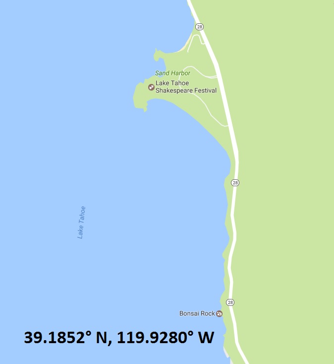
As I was headed down to El Dorado County again this weekend (for a beer-themed 5k run this time), I was hoping to hike up to Horsetail Fails, but when I had driven through last week the trail head looked to have too much snow. Instead, I decided a much less strenuous adventure. Just south of Sand Harbor on Lake Tahoe, an often photographed rock was my destination.
Bonsai Rock is a large granite boulder rising from the clear blue waters of Lake Tahoe. The rock gets its name for the miniature pines growing out of it's cracks. The small trees can't be more than 18 inches tall, but with the snow-covered mountains as a back drop and the blue waters of the lake in the foreground, this little boulder makes for quite the picture and is very popular among local photographers.

As the rock can't be seen from the highway, I punched the coordinates (listed in the picture below) into my phone and let Siri's voice take me to the proper pull off. My first trail down to the lake was the wrong one and while, it's not more than a few dozen yards, it is quite steep. I was able to see Bonsai Rock though and realized, I went slightly too far. Coming back to the road, I head back north just a few yards and quickly find another trail heading generally in the right direction. Again it's a steep trail, but within five or so minutes, I'm standing atop another granite boulder, the neighbor of Bonsai Rock, snapping pictures.
Really not much of a hike, as it is probably less than a quarter of a mile in total, but certainly a very pretty photographic subject.
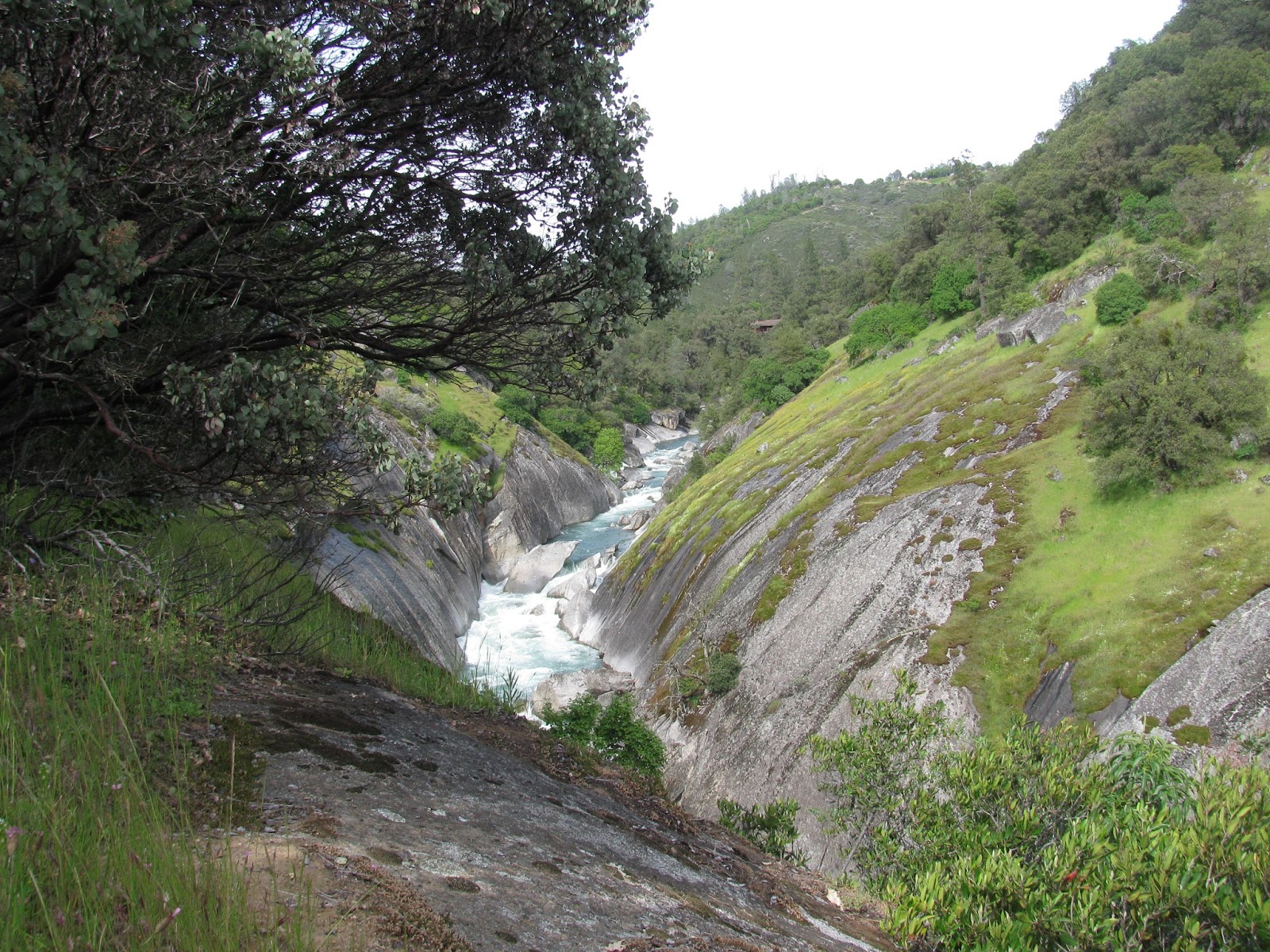
Each April, the wineries in El Dorado County put together a tasting event called Passport. It generally spans the last two weekends in April and is quite the destination weekend. I've attended the last four or so years and it has been a fantastic experience. This year, I decided to include a short hike while in the area. With all of the snow and rain we have had this winter, the snow melt is powering the rivers running out of the Sierra Nevada Mountains to amazing levels of flow. One of these, the Consumnes, happens to flow right through wine country. Along this mighty river is a section popular among rock climbers, known as the Consumnes River Gorge. It seemed like an interesting place for a short hike.

Parking along the side of the road where I believe the trail started, I made my way past the barricade and found a well-worn trail heading down towards the sounds of the raging river below. Passing through manzinitas and small oak trees, the tall granite cliffs start to come into view and the raging river below starts to echo off of the walls of the narrow gorge.
It's not much of a hike to get to the edge of the cliffs. Though it is steep and somewhat treacherous, it's probably less than a half a mile from where I parked to get my first views from above the river. The trail continues to snake in and around the cliffs. I can only imagine what this would look like during a storm, with the thunder creating an echo chamber and the rain sliding down the steep slopes of these nearly smooth granite cliffs.
After just a little exploration, I decide to head back to the jeep. With more time, I would enjoy exploring this area a great deal more, but given the wine in my system and the approaching sunset, it's probably best to call it a day.
This winter has seen the some of the heaviest snowfalls in the Northern Sierra Nevada Mountains on record. Unfortunately, I've only been out snowshoeing in it once so far. Time to fix that. Getting an early start, my friend, Brent, and I head over Donner Pass and look for a place to park at the north end of Troy Road, which does not get plowed in the winter. Our destination is Matrimony Tree, which sites alone an isolated ridge overlooking the valley separating it from Devils Peak.
The first part of the trip is relatively easy, as snow-mobiles have compacted some of the snow. And there is so, so much snow here. I note a couple of stop signs that have shield themselves from being completely buried in the white flood. Perhaps, if they had said "Please Stop" they would have done better with the snow.
Heading up the steep road, we pause to admire a small water fall carving it's way through the deep snow pack. As we have had a number of days already that reached above freezing, the run-off has began and given the amount of snow, we are likely in for more flooding in the valleys below. Still, it's peaceful to see this natural cycle in such dramatic fashion.
As we cross a railroad track, Brent mentions that he's getting pretty tired and suggests that he might head back. The snow-mobile tracks stop here and we're likely to be following cross-country ski tracks as we go into the forest further. I hate splitting up, but I know it's only going to get steeper as we push on. We agree that he will slowly make his way back to the jeep and I'll push on to the destination as quickly as possible. I want a good workout from this trip anyway.
Eventually, I reach a point where where I am on virgin snow. No one has been here lately, no signs of tracks of any kind, including animal tracks. I kind of like it that way. I sometimes wish I had been able to see the great western US prior to settlement, and while not exactly the same, seeing untouched snow fields like this is a close approximation.
The snow is deep and the hills are extremely steep. A couple of times, I have to cut around a tall bump, because I simply can't get enough forward moment to overcome the snow packing down. In the distance, I can see Devils Peak rising steeply out of the snow fields. It looks like a very steep climb to summit that one. Perhaps, I'll try that another day . . . in the summer or fall, when the snow has long melted.
I eventually reach the highest point and my destination. Matrimony Tree stands alone on the ridge. Legend tells that a young couple actually took their vows under the shade of this windswept centurion at some point long ago, thus the name. It's a pretty site for something so important, but as Brent is likely waiting for me, I simply take a few pictures and head back to the jeep. In total, I covered about 4.7 miles, which doesn't sound like a lot, but with all of the steep uphill and trail-breaking, it was a very good workout.
Last spring I went snow-camping with the Tahoe Rim Trail association. It was a great experience and I made a couple of friends on the trip that I've kept in touch with via Facebook and email. When Gehn sent a hiking invitation to Lydia and I, I really wanted to go. Unfortunately, I had already volunteered to work an event for the Nevada Humane Society this morning. Gehn and Lydia both agreed to wait for me though and so we met at the trail head of Stevens Trail just outside of Colfax about 3:15 pm. Unfortunately, I realized that I had forgotten my camera and so all attached photos are courtesy of my iphone's camera.
As we started the trail, it was great chatting with these friends that I hadn't seen in person in just over a year, but as we share a lot of common interests it took no time at all to get re-acquainted. Gehn and I have both hiked this trail a couple of times in the past, but it was Lydia's first time. Even so, we were all very curious about how the record-breaking precipitation in the Sierra Nevada Mountains this winter would affect the river and feeder creeks.
It didn't take long to find out. As we approached the fork, which separates mountain bikers from hikers for a short distance, a trail-runner coming other direction warned us that the hiker path was nearly impassable below the waterfall and advised us to use the bike path. We took his advice, but it still wasn't easy. Crossing over the falls proved to be a bit dangerous. It required us to leap across a fast-flowing section of the steep waterfall about three feet to a slick boulder sticking out of the water, with only thorn bushes to grab for upon landing. Luckily, we were all able to make the jump without any injuries beyond a couple of thorns in the hands.

Continuing on, we start to see the marvelous views of the North Fork of the American River far below us. Passing by the long-abandoned mine shaft, we invited Lydia to explore the stone crevasse, but explained that it only goes back a few yards before hitting a dead end. Apparently, the wood-be miners either tired of mining or determined there was no gold to be had in 'them thar hills'. Lydia declined and we continued on down the trail.
It seems we are just a couple of weeks early to see the wild-flowers that will undoubtedly blanket these hillsides. My last visit was late April a couple of years ago and the hillsides were a yellow, purple and white quilt upon an ocean of green flora.
One final barrier before we reached the river, another rushing waterfall, but this one considerably wider and requiring us to crawl across a pile of rocks and balance a 8-ish foot section of fallen trees to reach the other side. Again, we all made it safely.
Arriving at the river, we stop for a short rest and to get a snack. It's amazing how much water is flowing past us. Rocks that I have napped on during previous trips are vanished, likely submerged under the torrents. After our snack, we head back to the trail head and say our goodbyes. It was great catching up and we all agree that we need to do this more often.
Last spring while on my way back from a weekend in Napa Valley, I spent a little time driving down rain-soaked back roads looking for the trail head for a seasonal waterfall known as Phantom Falls. With the wet weather, I didn't look too long before heading on toward my next stop, but I've been thinking that I want to get back over to find that water fall. Due to some family matters that are going on, I've been pretty stressed out these last couple of weeks and I thought today would be a good day to relieve some of that stress by trying to find the waterfall again.
Arriving in Oroville, CA around 11:30 AM, I made my way out the winding Cherokee Road, which leads perilously above the edge of Oroville Lake. After about six miles, I begin seeing a huge number of cars parked alongside the road and hordes of people out on the wild-flower covered pastures. Apparently, many other people had the same idea as I did. There must be 500 cars and trucks parked here all along the road for half-a-mile either direction from the trail head. Families have set up lawn chairs and are flying kites out in the sea of cow patties and wild flowers. As I look for a place to park, I'm once again thankful for owning my jeep, as I can climb up inclines far better than the family sedans and mini-vans that are parked as far as the eye can see.

I head out into the pasture, northwest from the trail head. There is no true 'trail' here, but I assume at least some of the masses are headed that direction. Yellow, white, and purple wild flowers make it clear to all that spring is upon us. They make for a carpet for miles in every direction. The cows and rain seep have done a nice job of making something of a muddy mess in many sections of the field. I do my best to avoid the worst of it, but can't help bet get a little muddy.
Reaching the first of the two large gorges in this section of the North Table Mountain Ecological Reserve, I decide to pass it by and head for my destination at the top of the second gorge. As I approach, a use trail becomes visible. Obviously, all of this foot traffic has worn a path through the colorful field. As I reach my destination, I'm struck by the pillars of basalt that seem to make the base of this entire gorge.
I've seen columnar basalt formations all over the country, from Devils' Postpile south of Yosemite to Sheepeater Cliff inside Yellowstone. This one, however, is different in scale . . . much different. It almost seems that this entire area sits atop this type of volcanic stone and that the gorge before me is simply a section this giant basalt landscape that has been carved out by the running waters of the local streams and falls. In this distance, the columns, both in tact and those that have fallen into the gorge, make for a spectacular site.
Finally, looking to my right, I see Phantom Falls. It is healthy wisp of water flowing from a small stream and falling over the edge of the fallen basalt columns. At the bottom, a rainbow plays in the misty air, while the falls itself conceals a large cave behind. A number of people scatter the hillsides all around me. Some just taking in the view, while others play in the stream. I can't blame them, it is a beautiful site.
After inhaling this magnificent view for a short time, I decide to head back to the jeep. This time, I was able to follow more of a worn path, but it still passed through a few sections of mud. It was a good hike of 3.75 miles, despite the mud and masses of people. The waterfall and the wildflowers more than made up for it. If I visit again though, I'll try to do it much earlier in the day and avoid some of the crowds.