Temperatures in the valley were suppose to hover around the century mark this weekend. To escape the heat, I decided to do some car-camping up at Lake Tahoe. I had reserved a campsite for Friday and Saturday night a couple of months ago and this heat wave, makes me incredibly happy I did. I headed up shortly after leaving work on Friday. Once at the campground, I made short work of putting up my tent and getting a fire going, which allowed me to relax the remainder of the evening with a cold beer in hand. I had kind of planned to hike up to Lake Genevieve and Crag Lake in the morning. And so, I hit the sleeping bag fairly early.
Rising before dawn, I got some calories in me and then walked to the trailhead - just short stroll from my tent. As my path will take me into Desolation Wilderness, I take a moment to fill out the self-issue wilderness permit and attach it to my day pack. Whomever last picked up the other part of the permits the last time, forgot to close the bottom door of the collection box before locking it, which means that when I put my ticket into the slot, it simply falls through onto the ground. I stuff it into the actual slit and hope for the best.
The first part of the trail follows a forest road along the valley floor. However, the incredibly wet winter and subsequent melt has left this area a muddy mess, complete with pools of standing water and the legions of mosquitoes that come with them. To be honest, this part of the trail was pretty miserable and I almost turned around. Luckily, I remembered to bring some repellent. Unluckily, these particular mosquitoes are patient and don't mind waiting for the citranella to wear off. I decide to hope for the best and keep pushing onward. Eventually, I put some distance between myself and the stagnant pools, leaving the bloodsuckers behind.

As I make my way up the hillside, I pass through a number of open meadows as well as a beautiful marsh, which most of the time is Meeks Creek, but not this year. As I continue, I hear the constant sound of rushing water to my left, but unfortunately, the trail stays just far enough away to prevent any good views. It's quite a shame on a year like this. The trail in this section is in pretty good condition.
A bit further on, I get a partial view of what is likely a raging waterfall, but the terrain prevents me from getting any closer. I do find a section just above the falls that at least lets me see the rushing waters of the creek. It's amazing to see just how fast it is flowing. California (and Nevada) have been in a drought for the last few years and the record-breaking winter we experienced this year has pretty much put an end to that. It's great to see all of this water flowing into the lake.
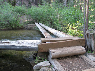
About three-and-a-half miles in, I reach a creek crossing. The forest service was nice enough to construct a sturdy bridge to cross here. However, all of the run-off from the mountains this year appears to have put the bridge to the test and it failed. The bridge appeared to have been constructed from four logs, of which only one is remaining and stable. One is completely gone. The second is laying against a fallen tree next to the shore. A third appears to have broken about six feet from this end and is now in the rushing waters. The fourth one though is still there and appears to be holding strong. The water here, while a bit calmer than downstream, is still flowing like crazy and appears to be about four feet deep. I take measure of my situation. The mud and the mosquitoes all most made me turn around earlier, but this wash-out bridge is the proverbial straw.
I decide to head back and forgo seeing the lakes. It was still a decent hike and I may try it again sometime, but later in the season when the bloodsuckers are gone. In total, I got in about 7.5 miles by the time I get back to my campsite. I'm hot, sweaty and smell of mosquito repellent and sunscreen. Conveniently, Meeks Bay Beach is just a few yards away. I put on some trunks and head over. The beach is full of people, but only a few are in the water. As soon as I walk in, I understand why. Instead of cooling off as I had hoped to do, I more 'freezing' off. Lake Tahoe sits high in the mountains and the water is always cold. It's been a while since I've taken a dip in the lake and I had forgotten just how cold. This water is freezing!!! Oh well, I dive in to rinse the cacophony of odors from me and then head back to camp and pop open a brew.
Some time ago, I read about a small peak overlooking Frenchman Lake, which is north of Reno. The peak is reportedly crowned with a solid crystal block. Several months ago, I attempted to find the jeep trail to the top, but ended up in deep in the forest with the 'road' passing between trees two narrow for my jeep to traverse. I gave up that day, but vowed to return and find the correct path.
After further research, I was convinced I had found the proper jeep trail up the mountain and decided to give it another try. As I'm not a super-experience off-roader, I wasn't sure if it would be all driving, all hiking, or some combination of the two, but I was determined to see this wonder.
After leaving Frazier Falls and heading back towards Reno, I took the turn towards Frenchman Lake and then proceeded to what I believed was the proper trail. As I started down the rough dirt road, I passed by the turn I had made last time and passed it by with a smile on my face. Continuing on, I encounter a jeep and truck coming the opposite way as they pass through some trees off the main trail. As I'm looking into a deep, muddy pool with deep, deep tire ruts coming out of the other side, the folks mention to me that it is far deeper than it looks. Taking their advice, I decide to bypass the deep pool and take the jeep through the trees.
A short distance further, I come to a fork in the middle of the forest and take a sharp left, following the sign and my directions to my destination, Crystal Peak. The trail is mostly dry as it hugs the mountain side. In the distance, I can see the lake below and wonder how far I will be able to take the jeep. So far though, the road has been pretty easy.
After about four miles, things get more challenging. I'm forced to climb the jeep up steep inclines over a number of large boulders embedded in the road. Mud puddles, boulder-crawling, sharp blind turns, and tree branches smacking the side of the jeep are the norm as I traverse the final two miles to the peak. It's rough going and pushes my 4x4 driving experience to its limits, but I have to admit that I'm really enjoying seeing just what this beautiful machine of mine is capable of.
The final push to the peak is a muddy mess of a steep uphill followed by a sharp turn, avoiding boulders and fallen trees all along the way. Finally though, I reach the top and there is no doubt that I have arrived. I park the jeep below a tall pine tree and walk to the white crystalline peak. A lone pine tree grows right out of the solid crystal slab and is home to a number of birds and insects. As I climb up the flaked crystal to the very top, I scare a number of these creatures from their home. Seeing all of the crystal here is quite amazing. While I've seen a lot of this material in the past at various sites, seeing an entire mountaintop made of it, is something else entirely.

Having accomplished my goal and taken the jeep the entire way to the top, I head back down the road. Easy as I can, I slowly crawl down the hills and over the boulders I had climbed on the way up. It was a great experience and I'm glad to have finally crossed this one off of my list. Chalk this one up to "Reason I Love my Jeep #4568".
During the winter of 2015-2016, I joined a new meetup group and on the day after New Years Day, we snowshoed to a waterfall I was unfamiliar with near Graeagle, California. It was a 10-ish mile trek to see the frozen waterfall, but it was definitely worth it. Even in winter, the waterfall was majestic.
For a while now, I have been thinking about returning to see the waterfall in spring. With this past winter having had more snowfall and precipitation than any year on record for much of the northern Sierra Nevada, I couldn't let a chance to see this waterfall flowing at maximum escape me. While my legs are tired from running the half-marathon yesterday, I knew the hike was very short and extremely easy.
Since the waterfall is only about a 75-minute drive from Reno, I didn't leave exceptionally early. I arrived at the trail head at about 11:30 and found the parking lot at the trailhead nearly full. Apparently, a number of other people had similar ideas. The trail is paved all of the way to the overlook. I didn't actually realize this since during my last trip, there was a couple of feet of snow over the trail. I pass several people along the short half-mile path to the falls overlook. Both the young and old enjoy visiting such a scenic place and they are out in force today.
As I arrive at the overlook, I see exactly what I expected. Frazier Falls is alive with activity as thousands of gallons of water flow over the rocky volcanic outcropping to fall 200-ish feet to the creek below. I speak with several nice people at the overlook, as we collectively take in the amazing view.
After a short time, I decide to head back to the jeep. The hike was only a bit over a mile, but that's probably a good thing given the fatigue I feel in my legs this morning.
Last year, I ran my first half-marathon (and this year, I ran my first full marathon). The Rock Tahoe event from Spooner Summit to South Lake Tahoe was an amazing experience. The combination of scenery, the overall electricity of the event, and the great organization made it an amazing experience. So much so that I decided to run it again this year.
Unlike last year when I had to wake super early to get to South Lake Tahoe in time for the shuttle, I decided to just spend Friday night at the Hard Rock Hotel & Casino in Stateline, NV, which hosts the event. I arrived at the hotel at just about dusk and proceeded to check in to my room, which was very comfortable. I went down to pick up my race packet and bib, and then decided to grab a beer and a quick bite at one of the casino's lounges. I got to talking with another runner, which made for an enjoyable evening. I got back to my room about 9:30 pm and decided to crash.
I awoke at 4:50 AM, shortly before my alarm was scheduled to go off. I woke myself, got a quick bite, and a shower. I then spent a fair amount of time applying a liberal amount of sunscreen. Today is supposed to be pristine weather for the run and I don't really want to get burnt. At about 6:30 AM, I head down to catch to the shuttle and ride up to the starting line at Spooner Summit. On the way, I have pleasant conversation with a fellow runner, with whom I trade war stories. This being my third half-marathon, I feel as though I have a little experience with this type of event now.
At the start, I make a couple of visits to the porta-potty, hydrate myself, stretch my legs, and meet up with several of members of my RTO team who are also running this morning. Unlike last year's event where it actually snowed on us a little bit at the start, this morning is quite warm. The pre-start activities are lively get all of the 3,000 runners pumped for the endeavor we are all about to pursue.
At the stroke of 8:00 AM, the the countdown finishes and we are off. Seeing this number of people take the short loop out of the parking lot and then trot onto highway 50 is quite a site to see. It feels good to be among people who take fitness so seriously and while I was probably in slightly better shape for last year's event, I still feel pretty good. The first three miles of the run are downhill as we leave Spooner Summit and make our way down to the gorgeous blues of Lake Tahoe. Unlike last year, the mountains that make up the Tahoe Rim are still snow-capped, thanks to one of the wettest winters on record.

The first three miles go by pretty fast and I feel pretty good at the bottom of the hill. I continue along the straightaway and take advantage of the aid stations offering various hydration and fuel options. Continuing on, push hard as we make our way up the undulating hills and dips of the highway. The views are amazing, as the scenery of Tahoe always is. It is very hot though and I'm sweating like crazy. I decided to wear a tank top today, as I expected it to be warm, but even so, I'm hot.
At approximately mile 8, I feel a arthritic-like pain in my left foot. It doesn't let up and I'm forced to walk a bit as the pain becomes pretty intense when my stride lands on it. After about a half-a-mile, I encounter one of the first-aid personnel patrolling the course on bike. I ask if he has any ibuprofen. He doesn't, but offers some acetaminophen, which may not be as good, but does help with the pain and allows me to run the next couple of miles without much pain.

Unfortunately, the pain in my foot does return and I'm forced to walk again at about mile 10. For the rest of the race, I will be alternating between running with a grimace on my face and walking at a super-fast pace. As we enter Stateline, I know the finish is near and I try to push myself towards the finish line. I make the turn into the Hard Rock Casino's parking lot and give one final push as the finish line comes into view. It hurts, but I'm determined to finish strong. I'm not sprinting, but I'm running at a pretty fast pace as I finally cross the line and allow one of the volunteers to place my finisher's medal around my neck. A few feet past the finish line, I'm offered and accept a cold Sierra Nevada Pale Ale, which makes the finish all the better. A few feet after that, I'm greeted by my RTO teammates who congratulate me.

My time this year wasn't nearly as good as last year (2:39:17 vs. 2:17:38), but last year, I wasn't in pain when I was running. It doesn't matter though, I feel pride in having completed another amazing half-marathon.
About eight years ago, I spent a couple of hours hiking out in the baking sun of the Alabama Foothills searching for a specific natural arch noted in a hiking guide I had used for a number of years, I failed to find the arch, but did find an amazing place for off-roading and hiking. Three years ago, when my friends Van and Bill, and I made our first attempt at Mt. Whitney, we explored this location a bit, but still didn't find the arch. With no set plans for the outdoor adventures of this weekend, Bill and I decided to head across Death Valley to Lone Pine and finally find the Mobius Arch of the Alabama Foothills. Little did I know what an adventure it would turn out to be.
Leaving Valley of Fire State Park, our drive took us through the north end of Las Vegas, but instead of returning on US95, which is the most direct route home in Reno, we needed to take a detour across into California and return on US395. Instead of taking the normal route through Death Valley, I decided to take Bill through the jeep-friendly Titus Canyon, which I described to him in the past. The trip through the slot canyon would add some time to the trip, but it's an amazing ride in a jeep and seeing the slot canyons reaching hundreds of feet on either side of the narrow path is something that can only be experienced, not described.
Finally, we popped out into Death Valley to find winds so strong they would almost knock a standing adult over. While problematic in most places, winds like this pose an additional danger in Death Valley - sand storms and this one was raging!!! If you've ever seen the 1999 movie, The Mummy, you might have some idea of what we were dealing with. Luckily, the storm through the Valley of Death was blowing parallel to the road and so didn't pose much danger. However, once we turned toward Stovepipe Wells on CA190, we new our luck was about to change.
Huge volumes of sand were being lifted from the valley floor and flung by 70-80 mph winds across the landscape rising a miles into the sky and covering the length of the giant valley. When we reached the worst of it, we made the choice to enter the natural danger. We knew it would be additionally problematic since the top was down on the jeep and the strong winds precluded the possibility of putting the top up. We rolled up our windows, for what little good that would do (the entire back and top were exposed) and entered the heart of darkness. Sand slapped my face and got into my eyes and nose. Visibility was five feet or less at most moments. The cars in front of me would creeped at a pace of no more than 3 or 4 mph as we braved the storm. The 15 minutes or so it took to traverse the worst part of the sand storm was one of the most frightening driving experiences of my life, but coming out the other side, I knew we had a story to tell. The jeep, our gear, and even our selves were covered with fine sand grains. It was in our eyes, in our mouths, and in our noes. It was everywhere. So much so, that once I finishing typing this blog the next item on my agenda is to go vacuum out the jeep. However, we made it through without incident!

Arriving at Lone Pine, we turned up Whitney Portal Road and the right onto Movie (or Movie Flat) Road, we began taking the jeep on the confusing network of jeep trails looking for the arch. I thought I had good directions, but I had apparently failed to copy the entire document and only had part of what I needed to find the arch. After a short time exploring, we decided to take a break and grab some dinner. While we ate at a nearby burger joint, I searched for the missing directions.
Now armed with detailed directions and a full belly, we headed back into the hills and quickly found the obvious trailhead, as marked by the Heart-shaped Arch described in my earlier directions. As sunset is quickly approach and my resolve to find the arch burning inside me, I tell Bill that I'm likely going to run to the arch. He understands and decides to remain with the jeep.
At first, the trail is well-marked, but soon splits without clear signage of how to reach my desired destination. I end up trail-running at least half-a-mile in the wrong direction. I run back and finally see some photographers in the distance. I walk through the open-desert to reach them and ask for better directions. A kind gentlemen points to a stand of rocks just ahead of me and tells me that it is right around that corner.
With very little daylight remaining, I make a last push for the finish line. As I turn the corner, see the amazing Mobius Arch, named for the geometric mobius band, which is a conceptual construct where a strip of paper is connected end to end, but only after introducing a half-twist into the shape. The result is that one could take a pencil and draw a continuous line around every surface of the band. The arch is shaped very much like this and thus was named as it was.
I take a some shots (including one that frames Mt. Whitney within the arch), trying to get all angles, before heading back to the jeep. I didn't measure my hiked distance, but Captain Ahab finally got his white whale!
P.S. The drive home (with the jeep top still down) saw us through a Blizzard, sub-freezing temperatures, and a light rain storm once we reached lower ground.
Rising to a breezy warm morning after having camped in a remote canyon inside Lake Mead National Recreation Area, my buddy Bill and I begin breaking down our tents and packing our gear. The drive to the site was interesting as it was through what was probably a one-time tributary of the Colorado River, but has in recent decades dried to become a narrow slot canyon. It provided a great place to camp though and it happens to be very nearby our first planned stop of the day, the remains of St. Thomas.
The town of St. Thomas, NV was founded in 1865 by Mormon settlers, who abandoned the site after only a few years. Other settlers reclaimed the town and it seems to have thrived until the plan to create Lake Mead through the flooding of the plane where St. Thomas sat forced evacuation in the 1930's. Later in the 2000's when the water level of Lake Mead dropped, the town once again saw direct sunlight.
I remember a friend telling me of St. Thomas a couple of years ago, but I hadn't though about it again until a ranger at one of my other hikes during this long weekend had mentioned it. The location seemed like an incredibly interesting place to visit.
A gravel road leads a few miles out onto what would have been a peninsula until the last few years when Lake Mead has receded and a fertile plane. The trail leads down through a vast sea of foliage. Presumable, the waters have left an amazing amount of nutrients in the soil and left this area rich with life. Also interesting, are the millions of broken sea-shells that are buried in the sandy soil along the cut trail.
As we make our way down the obvious trail, we begin to see foundations and concrete slabs on the ground, along what were probably the streets and avenues of St. Thomas. Some of the buildings were obviously made by skilled craftsmen. We are both impressed by the number and more importantly the perseverance of the structures. Obviously the wood has long rotted away, but the foundations have withstood submersion in the flooded waters of the Colorado River for over 60-years.
Nearby, the block from a small V8 engine is laying on the ground. Whether it was from the town or used as a boat anchor, we can't be sure, but it is an interesting find nonetheless. It is one of many rusted steel and iron artifacts that litter the ground. Some previous visitors have laid many of their finds out on the exposed foundations.
We continue to walk the 'streets' of this ghost town, appreciating the size and breadth of the town. A notable structure is the abandoned school house, which from the size and durability of the structure, was likely a centerpiece of the community, and rightly so. The curved steps seem surprisingly modern, though they were from a completely different era.
Returning to the jeep, we take measure of how these people must have felt when they were forced to abandon their homes, which they scratched from the dirt. Were they compensated well? Were they simply 'show the door'? Hopefully, the evacuation was a good thing for them and they were able to find full productive lives elsewhere. The hike was only about 2.4 miles, but it was well worth it. Of note, the app I use to capture topography of my hikes posts to Facebook and while the final map correctly shows dry land, the preview map suggests as I was walking on water.
The next stop of the day turned out to be extremely difficult to find due to very recent and ongoing housing community construction. The Sloan Canyon Conservation Area was probably at one time far from the streets of Henderson, Nevada, but as the population of Southern Nevada continues to explode, new development pushes closer and closer to the federal border of the conservation area. Streets in the area are, in my opinion, very poorly designed as one way streets circle community areas, but make it difficult for out-of-towners to navigate.
Eventually, Bill and I reach the visitors center, which is nothing more than a trailer dragged to a parking lot high above the subdivisions below. As I mention the difficulty in find the site, the ranger comments that he hears that often and has left maps with many guard offices of the local communities in an effort to assist the lost and searching culture enthusiasts. He provides a map of our intended hike, Petroglyph Canyon, and offers some directional guidance before seeing us off.
The trail is well marked as it leaves the parking lot and enters a dry wash. Here, the trail is pretty unremarkable, but is representative of this hot dry environment. Soon, we reach a fork, described by the ranger, and head up the path to the right, knowing that the trail will loop around and we will return to this point on the left path. The trail has a slight grade to it, but the hike remains fairly uneventful at this point.
Finally, we turn back into the wash and just as I mention a distinct lack of petroglyphs on desert-varnish surfaces where I would most likely expect to find rock art, I turn to find our first example. Just above the trail, two medium-sized rocks have glyphs carved into all visible surfaces.
From here, we begin finding numerous petroglyphs on both sides of the shallow canyon. Some are lone on laying rocks, while others are part of large panels covering entire hillsides. The patterns here are mostly familiar, but a number of them appear to almost be character-like. These specific glyphs are in some cases are almost like letters or super-hero logos from an unknown cultural language. I comment to my friend, Bill, how much I think I would enjoy working as an anthropologist trying to decipher the meaning of these ancient marks.
As we continue around the loop, we reach a series of dry waterfalls that we must climb and jump down from. Each is from 6-12 feet high and the series of four or so falls are separated by 10-20 yards. It provides some excitement to an otherwise uneventful exit from the canyon.
Arriving back at the jeep, we begin to talk about camp locations for the evening. The hike was about 4.3 miles, but now it's time to think about relaxing. We have some time left and decide to head up through Valley of Fire State Park and either camp there or in the adjacent northern end of the Lake Mead Recreational Area.
After a relaxing evening of camping and beer drinking in a secluded canyon far off the highway on BLM land, Bill and I break camp and head for our second destination of this weekend car camping trip. This stop will take us far south of Las Vegas to the lower end of the Lake Mead National Recreation Area. I had read of a secluded canyon here that was home to a number of ancient Native American petroglyphs, as well as some other interesting features.
The trailhead is well-marked easy to find off of Christmas Tree Pass Road. As we are in the open desert, we ensure we pack ample water and then head up the obvious destination. Just as we start down the trail, we are greeted by two park rangers, who were apparently checking the site. We have a friendly chat with the ladies about the features of the canyon and other nearby destinations. The rangers ask if we would be willing to complete a short survey, which we are both happy to do, but unfortunately, we are unable to answer many of the questions about the facilities and services, as we have been inside the park for only a few minutes at this point. They understand and wish us well.

Almost immediately upon entering the canyon, we notice a number of detailed petroglpyh panels. The panels cover most of the rocks all the way up the cliffs on either side of the canyon's mouth. While many of the glyphs are familiar (big horn, wavy lines, etc.), there are also a number of unique patterns that I have never seen before and I have visited forty or more petroglyph sites all over the west in the last few years.
Some of the glyphs are almost like modern logos with multiple outlines around them. They are really interesting and as always, I have to wonder what ideas they were intended to represent by the artists that created them in the distant past. As always, Bill and I are careful to only take pictures of the rock art and not touch or interfere with them in any way. I want this symbols to remain and be appreciated by future generations for as long as nature will allow.
As we continue up the trail, which weaves between both sides of the canyon, we often see small white desert lizards, who at every pause, raise their tails high in the area before skittering off under rocks or foliage to hide from the invaders.
Interestingly, the rock here, at least at the base of the canyon, appears to be granite as opposed to the sandstone that forms the walls. A biologically-rich yellow water flows through the center of the canyon and cuts small falls into the granite.
A short distance up the canyon the petroglyphs become much more sparse, but we encounter the reason for the canyons name. Growing out of the small trickle of water, are an insane amount of wild grape vines. They create a dense forest here in the middle of the desert. How these grapevines arrived at this place may never be known. Perhaps some settler tossed some grape-seeds after a nice snack and now, decades later, a lush jungle has been the result. However they arrived, they offer a unique feature to this amazing place.

Eventually, we reach a point that to travel through would likely damage the foliage and decide to turn back. As we make our way back towards the trailhead, we careful watch for areas where rattlesnakes might be hiding from the direct sunlight. As we both know, snakes are not able to regulate their body temperature like mammals and will often sun themselves to maintain body heat in the morning or evening, while crawling under rocks or shrubs in the heat of the day to cool in the shade. Just as Bill mentions something about watching for rattlesnakes, I point to one in a nearby rock crevasse and ask "like that one?". The little guy coils up and raises himself in preparation to strike. We don't want to stress him or end up with a nasty bite and so, we give him space and put some distance between us.

Further down the trail, I notice a boulder with a line of big horn sheep petroglyphs on it. I somehow missed this earlier, but it's a fantastic piece and I have to get another picture. I carefully make my way up the canyon wall to get close enough to for a shot.
Finally, we arrive back at the trailhead. What an amazingly rich place. Between the glyphs, the rock formations, the foliage, and the fauna, this has been an outstanding destination and even though our hike was only a bit over a mile, it was well worth the visit.
Between changes to permit systems and ever-changing weather, my plans for this weekend have been all over the place. From backpacking the Lost Coast of California to car-camping in and around Cape Perpetua, Oregon, my buddy, Bill, and I ended up heading to Southern Nevada with a few ideas of hikes and camping areas.
Our first stop was a place I had visited last fall. Ash Meadows National Wildlife Refuge is a detached unit of Death Valley National Park and was established in 1984 to protect an ancient desert oasis that is home to a myriad of wildlife, including several endangered species. The Amargosa Valley where the refuge is located is a dry and dusty desert skillet, and so to find a lush oasis in such an inhospitable climate is quite surprising. It is no wonder that so many species call this area home.
We first drive out to the Crystal Spring Reservoir, which is a fresh water ocean in this stark yellow wasteland. The shallow lake shimmers in the hot desert sun with amazing shades of blue and gray. Ducks swimming in the rippling waves covering the two to three acre surface. Along the edge, tall grasses grow in the shallow water and in the distance small ash trees line the far side of the lake. It is a truly gorgeous site.
Next we drive out to Point of Rocks, which offers a short boardwalk hike in and around a spring-fed creek. The water here is crystal clear and offers views of the tiny pupfish that call this area home. Over the eons, different pools of the small creatures have been separated and allowed them to evolve into different species, including the famous Devil's Hole pupfish, which is critically endangered.
After our short walk, I show Bill the way up to Devil's Hole, which was the primary reason for my last visit, before we head further down the road and find a place to camp for the evening. If you are ever in the area and in need of a little revitalizing distraction, I would strongly recommend paying this magical place a visit.
The first weekend in June means one thing to 250 teams in the Greater Reno-Tahoe area - The Odyssey. The Reno-Tahoe Odyssey is 178-mile relay race that starts in Reno, runs through Truckee, down the western shores of Lake Tahoe, up into the mountains above South Lake Tahoe, through Washoe Valley, into Carson City, up into the silver-rich hills of Virginia City, and finally through pretty much all of Reno Proper to end, near where we started along the Truckee River flowing through Idlewild Park in Downtown Reno. This is the 13th anniversary of annual event and it has become quite a big deal in the area for around 3000 runners and another 1500-2000 volunteers and supporters of the event.
Generally, each team is comprised of 12-runners who each run three legs over the course of 20-30 hours. There are some exceptionally hard-core teams who try to run the distance with less than the recommended twelve members, but those people tend to be a little crazy, lol.
Last year, I was luck enough to join the most amazing group of people in the world to tackle this monumental event. Nice Asphalt is actually two teams, meaning we have 24-runners, we don't shorten the distance, we simply run in pairs. So our team actually runs two Odyssey's simultaneously, making it all the more fun since each runner nearly always has company along the hard road miles.
Each year, the members of the team change a little bit as life can get in the way and alter each individual's availability, but the team core remains strong. Tragically, we lost one of team captains, Suzanne, to a traffic accident shortly after last year's event. She was the heart and soul of the team, and her loss has been felt by each and every one of us. Instead of being the end of the team though, her absence seems to have strengthened our bonds of friendship, which is a great tribute to the kind of person she was and the impact she had on the world. I truly believe that her spirit was running with each and every one of us along the race this year.
Preparation for the event begins many months in advance, as we figure who can participate in the coming year, begin to organize, and start putting in those hard miles to train. The night before the event, we met to prepare the two 15-passenger vans that would care us and our supplies to each leg of the event, as well as support the runner currently pounding the asphalt.
Finally, the morning of the event arrived and the entire team met at Wingfield Park in Downtown Reno to cheer our first runners on. As each runner progresses along the course, one or both vans provide invaluable support in the form of water, super-soakers to keep the runner's cool, and perhaps most importantly, moral support. Nice Asphalt is without a doubt the absolute greatest team with regards to van support.
This year, my legs to run were 7, 19, and 31. The combination of these three is the most difficult set, according to Race178 who organizes the event. As I have not been training nearly has hard as I should have after my marathon in March, I was a little concerned. Mostly, my worry was because the last two legs, while short, are up some of the steepest inclines along the course. Nevertheless, I was going to give it my all. If I had to walk some of the steepest sections.


After the runners in van 1 finished the first six legs of the course, they handed off the 'baton' and went off to rest for a few short hours while my running partner, Mike, and I kicked-off the first set of van 2 legs. Leg 7 is 7.4 miles long and is considered 'more challenging' for a number of reasons. The majority of the trail runs along dirt roads instead of pavement and cannot be supported by the van due to the remoteness. There is a lot of uphill, but nothing terribly steep. However, the dirt roads lead to a great amount of dust, making it challenging to breath at times as dirt bikes and OHVs drive by. Making it worse, my digestion system decided to get a bit angry towards the end of the leg and I had to take it easy to avoid having a 'messy accident'. When we finally reached the exchange point, I headed for the provide porta-potty and took care of that problem. We didn't make great time, but we had a great run as we passed through some beautiful wide-opened meadows and even saw a deer along the way.
While the other runners in my van ran their legs, I did my best to provide support. Every quarter-mile to mile, depending on where suitable pull-offs where available, I and others hop out of the van and offer water, take unwanted layers, and provide a water soak for our the current runner. After we finished our legs and van 1 took back over, we headed to South Lake Tahoe, grabbed some food at the local grocery store, and then parked at the next van exchange near Heavenly Ski Resort to catch some much needed sleep.
I was able to get maybe an hour and half of sleep in my sleeping bag on the hard asphalt of the Raley's parking lot. It wasn't good sleep, but it was better than nothing. Waking at about 12:30 AM, I threw on some cold-running gear, as my next leg, 19, would climb the steep incline of Kingsbury Grade as it rises out of the Tahoe Basin. It's already cold, but at the top, it is sure to be much colder on this dark night. As our leg 18 runners approach the exchange point, Mike and I take off down the sidewalk. The first mile or so is relatively flat as we pass by through the shops of Heavenly Village and then cross back into Nevada and run by the late night party crowd leaving the local casinos. Some are well on their way to drunkenness, but others know what is going on and cheer us on.
Finally, we hit the stop light and the uphill begins. It's cold, it's dark, and it's steep. Leg 19 is considered one of the 'most difficult' as it rises over 1000 feet vertically over the last 3 or so miles. The run organizers require all runners to wear reflective vests, flashing lights, and head lamps through the evening, late night, and morning hours to help keep us safe from traffic. Additionally, local and state law enforcement in both Nevada and California are out in force to help keep motorists honest to the speed limits and raise awareness of the runners along the roadways. As I pass through the dark twists and turns of the course, I can hear and occasionally see a creek flowing below and beside the road. I keep an eye out for black bears, who are extremely prevalent in this area, but I never see one. I'm not very good at running up such steep grades and a few competing teams pass me, but I persevere and finally reach the exchange point at the top and hand off to our next runners.


This time I leave van support to my fellow runners and attempt to get a little more sleep while curled up in the passenger seat of the van. It's cold and uncomfortable, but get a few more minutes of rest over the next couple of hours. As the sun starts to rise, I begin to stir and start providing more support to my teammates. Finally, we arrive at the next van exchange and head to some hotels rooms in Carson City we reserved for a bit more sleep and much needed showers. By this point in the night, the aroma in the van is a little funky, lol.
The twelve of us quickly shuffle into our three rooms and figure out furniture to sleep on. The rest is short-lived though and as the 10 am hours approaches, we reload and head to our next van exchange in front of the Bucket of Blood Saloon along historic C-Street in Virginia City, Nevada.
Mike and I launch and start leg 31, which is also rated as 'most difficult' as it rises out of the Virginia Range north of Virginia City and climbs into the silver-rich mountains. Luckily, this is a short leg at 3.2 miles. The sun beats down on us, but perhaps fatefully, there is a fair amount of cloud cover today. It's still warm, but it could be much, much worse. The nature of the curvy road doesn't offer a lot of pull-outs and so van support is somewhat limited, but my team does everything they can to cheer me on as Mike and I climb the steep hills. My ankle starts to hurt quite a lot and I'm forced to walk some of the leg, but I eventually reach the hand-off and pass the torch to others. Finally, my running legs are done. Now it's time for the remaining runners in van 2 to bring us home.


As the day progresses, the heat intensifies and we do our very best to keep our runners hydrated and cool. Around leg 34, van 1 catches up and we start offering double support to our current runner during the hottest part of the day. Now the course passes through the residential and commercial areas of Reno. As one of our runners begins to succumb to the heat, others jump out to run portions of her leg and allow her to cool down. That's what is so amazing about these people and about this event. It's not about running the fastest time. It's about seeing every one on the team cross that finish line - healthy and happy.
Finally, the last leg is upon us and as Raj and Jen enter the Idlewild Park, our entire team joins in dressed in our team shirts to cross the finish line together. And there you have it, Nice Asphalt has put another RTO on the books. Now it's time for food, beer, and relaxation. There is no substitute for the feeling of accomplishment and team spirit that each of us has for this great event and for our brothers and sisters who pounded that asphalt all along the way as we ran 178 miles through some of the most beautiful country on earth. I can't wait for next year!!!