Saturday, April 30, 2022

Founders Grove (Humboldt County, California)

The next stop for Miranda and I on our way to the half-marathon takes us through the Founder's Grove of coastal redwoods. I was lucking enough to discover this short trail last fall when I was backpacking near here. I thought it might give her a great chance to walk among the giants. After parking the jeep, we headed into the forest and were immediately greeted by the patriarch of the grove, the Founder's Tree. Rising some 346 feet into the gray skies, this giant redwood has a trunk diameter of 12.7 feet and a circumference of 40 feet at the base. You would have to climb 190 feet to just reach the lowest limb on this magnificent specimen. 

After regaining our senses, we head deeper into the lush green forest to see other giants. Some of them have been partially hallowed out by fire. I explain that the trees have some resistance to fire and that's what allows them to survive these infernos. In addition to the standing trees, there are a number of trees that have fallen at various points in time. The most interesting is perhaps a series of three giant redwoods that fell on top of other and splintered their trunks into gigantic toothpick like structures. It's hard to imagine the crashing sound and rumbling earth that anyone nearby must have felt with these giants met their end. 

The whole trail is only about a mile, but provides a great taste of what this area is all about with regard to the coastal redwoods. I think Miranda was thoroughly impressed with the mighty trees of this grove. Once we returned on the designated loop, we headed to the jeep and departed for some dinner.

Childrens Forest Trail (Humboldt County, California)


While my road trip with my friend, Nick, was now over, my vacation was not and after spending a couple of days visiting with other friends in Reno, my friend, Miranda, and I headed to Redwood Country. There is a half-marathon that we are both interested in tomorrow and since she has never had the chance to spend much time with the redwoods, it seemed a good time to get in a few hikes among the giants. 

I did some research and picked out a couple of short trails that were along our route. The first was the Children's Forest Trail, which from the pictures available on alltrails.com seemed like an excellent choice. We parked her jeep and headed down the trail, which had us arriving at the Eel River just few moments later. The trail has us following the river bank for perhaps a quarter of a mile and then crossing the river over a bridge and exploring the giant redwoods on the other side. One major problem though . . . no bridge. I'm not sure if it was washed out or what happened to it, but it left us no way to safely cross the rapidly moving river and not wanting either of us to be swept away, we decided to abandon the hike. It's disappointing, but hopefully, the next one I chose will be a better.

Wednesday, April 27, 2022

Fossil Butte (Lincoln County, Wyoming)


 Our final stop for this long road trip sees us visiting Fossil Butte National Monument in southwestern Wyoming. We arrived early with very little in the way of expectations. Nick has checklist addiction and this was one of the few National Monuments he has not visited, which is what prompted us to drive all this way. I share this addiction, but not to the extent he suffers from it. Either way, from the quick reading I had done prior to the trip, it seemed like an interesting place to visit. 

We arrived just as the visitor's center was opening for the day and took our time wandering around looking at several of the fossil specimen that have been recovered over the decades from the rich layers of the butte just a mile or two from here. We also took time to watch the educational video the park service provides to familiarize visitors with the location. It's interesting. We had originally planned to do a hike through the quarry, but with the rangers mentioning that the real treasures are here in the visitor's center and with Nick's knee hurting him a bit from the hiking we've already done on this trip, we decided to forgo the hike. After a final walk through the museum area, we head back to the car, point the car towards Reno, and begin our long drive.

Tuesday, April 26, 2022

Red Canyon Overlook - Flaming Gorge (Daggard County, Utah)


After departing the amazing rock at McConkie Ranch, Nick and I headed north towards the Wyoming border. Flaming Gorge was directly in our path to our final destination on this road trip and since he had never been to it, it only made sense to stop. We arrived in the later afternoon with a deep hunger for some good food. Before we filled our bellies though, we decided to fill our vision with the magnificent views from the Red Canyon Overlook.

As we pulled into the parking area, a small heard of five or so big horn sheep were grazing on the soft grasses nearby. Apparently, these animals were reintroduced a few years ago and have thrived ever sense. Leaving the car and heading out the paved walkway to the overlook, we were greeted with a stunning view of the Green River far below us, with steep red and white cliffs and dark green foliage scattered about rising up to the elevation we were viewing from. I've been to this place before, a few years ago, but it still impressive. With a few pictures, we were on our way to our accommodations for the night and then onto Wyoming.

McConkie Ranch Petroglyphs (Uintah County, Utah)

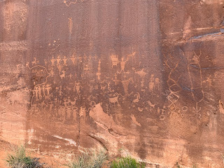
. . . And we're off to see more petroglyphs. After having visited Nine Mile Canyon yesterday, I wasn't sure that anything could top it in the way of rock art, but this next stop certainly gives it a run for it's money. Nick had visited McConkie Ranch previously and suggested that we stop so that I could see the amazing works here. I'm so very glad that he did.

This place is in the "middle of nowhere", Utah and requires a detour of a few miles. Once we arrive, there is a grassy parking area with a map to the rock art areas. Interestingly, there are homes built at the base of the cliff where the rock art was scratched and painted. Apparently, the residents have gotten tired of people plodding through their yards and have set up a designated trail that takes people away from their homes, but still allows access to the treasures above. Thank you residents of McConkie Ranch for this wonderful compromise.

The trail first takes us across a grassy cow pasture and then up a step incline with several switchbacks before reaching the first panel. It's a challenging hike, but once I catch my first glimpse of the panel, I know immediately that it was worth the energy to get up here. 


These petroglyphs are unlike any I have ever scene. The human figures are decorated with fancy clothing, head dresses and jewelry. Some of the petroglyphs have dye inside parts of them, leading me to believe the images were once painted in addition to being etched into the hillside. There are so many and they are all so elaborate. I'm just going to post several pictures here to give my readers a taste.

One section has a sign pointing up the cliff and after hopping on a large boulder and looking up, I can see the Great Bear that was carved into the sandstone. This image seems familiar to me and I believe I have seen it somewhere before, but I can't quite place it. Perhaps, it was simply when I was reading about this place and it's artwork.

After exploring the path high above the road and all of the works up here, Nick suggests that I continue down the other trail to see the Three Kings Panel. He's going wait in the car. I expect it's just a short distance and so, I agree. Little did I know that it was more like a mile and a half away, through cow pasture, alongside a murky pond and finally, through the rattlesnake heaven of open desert. The sign told me to follow the orange flags, but they disappeared quite a while back and I'm just guessing my way to the panel. Finally, I get there and see a sign pointing upwards to the tall cliff a distance away. There, some eighty feet or so, above the desert floor, the decorative images of three or more humanoids watch over this valley. These must be the three kings. It's a great panel, but I'm not entirely sure it was worth the walk out here given the richness of the other portion of the site. Either way though, I'm glad I made the journey. Overall, this is one of the most amazing rock art sites I've ever visited. Truly astonishing petroglyphs and pictographs.

Green River Trail - Dinosaur National Monument (Uintah County, Utah)


Another day, another adventure in the wilds of Utah with my friend, Nick. Today, we start our journey by exploring Dinosaur National Monument, which we have each been to before. We spend a little time in the Quarry Exhibit Hall, which I detailed in a write-up of my last trip. For Nick though, this building was being constructed when he last visited and so, he's fascinated by the actual fossils protruding out of the giant quarry wall. Rightfully so, it's an awe-inspiring visual.

After we get done with the fossils, I suggest we get a few hiking miles in to stretch our legs. We head further into the park and stop at the Green River Campground. There is a trail that runs alongside and above the river here and leads to another campground, Split Mountain, a little ways to the north. It seems like a good place to stretch our legs. As we get going, Nick becomes a little disillusioned with trail as there is nothing more to enjoy than some gorgeous scenery. He decides to turn back, but tells me to go ahead. All good - I can move quite a bit faster by myself and really get the blood pumping a bit. 

The views overlooking the river are quite beautiful and I have to stop a couple of times just to breathe in the vistas. After a short time, I make it to the other campground and turn back the way I came. I make really good time and get back to the car just a moment or two after Nick had gotten there. I was moving pretty fast. It was only a 2.5 mile hike, but it was worth it to get some more fresh air and see this gorgeous valley.

Monday, April 25, 2022

Nine Mile Canyon (Carbon County, Utah)


For many years, nearly as long as I've been interested in Native American rock art, I've been hearing about a place in Utah called Nine Mile Canyon, which is supposedly a treasure trove of petroglyphs, pictographs and even some long-abandoned structures, all created by the ancient Fremont People who lived in the area some thousand to two-thousand years ago. While my friend, Nick, and I have been exploring a number of sites along the way, the primary focus of this vacation and road trip through Utah has always been a drive through Nine Mile Canyon. 

The name of the canyon is a misnomer though, as the canyon is roughly forty-five miles long. Why it the canyon and the creek that cut it are known as Nine Mile Canyon is lost to history. Poorly named or not, the canyon is renowned as the longest art gallery in the world. As both Nick and I have a keen interest in rock art, this should be an amazing day.

After departing Moab this morning and exploring the dinosaur tracks at Copper Ridge, we headed north towards Wellington and the entrance to the canyon. Apparently, much of the road has been improved in the years since many of the write-ups I've read in preparation were written and now it is almost entirely paved. That's probably a good thing as our rental car has already suffered some thorough abuse traversing across gravel, sand and dirt roads as we've made our way here.

Initially no different than other canyons of the region, this one has rugged hillsides with the occasional hoodoo rock formation carved by wind and water. It's width varies from section to section, but never really exceeds more than a quarter of a mile or so. After driving several miles along Soldier Creek road and enjoying the vistas, but not seeing much in the way of rock art, we finally come upon a sign indicating the start of the outdoor museum known as Nine Mile Canyon. 


Almost immediately, we begin seeing petroglyphs carved in the red sandstone to our west. We hop out to examine several locations. At one point, I hop out of the car to snap some pictures of a panel, while Nick waits. After reaching the panel though, I motion for him to kill the engine and join me. Below the petroglyph panel and protected by an overhang several red humanoid figures have been painted on the smooth surface. We found our first pictographs in the canyon!

For the next few miles, we encounter panel after panel along the canyon wall and stop to take pictures of most of them. May are fantastic, but most are very similar in style. As we approach Harmon Canyon following a blog we've been attempting to use as a guide, we get out of the car and begin walking up a long, wide wash looking for petroglyphs on both sides of the side canyon as described in the blog. After splitting up to cover more ground and making our way up approximately a mile, we've only found a single petroglyph, which is a magnificent stylized horse. This is nothing like what the blog described. We've seen lots of cow bones in and among the sagebrush, but only that single petroglyph. Returning to the car, we question where we had gone astray only to find a second sign for Harmon Canyon, with a cliff wall loaded with rock art. The author didn't mention two signs. Oh well, it was nice to stretch my legs for a bit.


Once gain returning to the car, we push on and begin looking for some structures described in the blog, including a watchtower jutting finger of the far side of the canyon and a small granary tucked away precariously under an overhang. How in the world did they get up there to store and later collect their grain? It seems impossible and if not impossible, far to challenging a climb just to make some form of flat bread. Wow!


Pushing on, we encounter petroglyph panel after petroglyph panel. It's a veritable amusement park of pre-historic rock art. The reputation of this place is well worth it. One panel, which is punctuated by a large snake petroglyph, requires us to climb up a rocky hillside to the cliff wall for a closer examination. It's a little challenging and I think Nick kind of regretted it if his heavy breathing was any indicator. The panel was nice though and it felt good to get my heart pumping a bit. We leave in disgust.


Another very interesting panel is the Owl Panel, which requires a short walk up a side canyon. This panel has a number of images on it, but the most obvious is that of a great horned owl flapping it's wings. There are more panels around this one, but the owl is the highlight. We decide to move on.


I'm truly in awe of this place. So many ancient artists must have spent their time in this canyon carving their masterpieces for all time. So one would hope. Our next stop takes us to to Rassmussuen's Cave, which is nothing more than a wide overhang. Underneath the natural shelter though a number of pictographs have been painted in red to decorate the area. Truly amazing images of buffalo, deer and other creatures. And then, a terrible stain on our modern world. Someone, presumably a local land owner, has painted in bold black letters "This is Private Property. No Trespassing" directly over the image of the most amazing deer, spoiling this masterpiece for all time. How hateful and ignorant can people be! 


Further down the canyon, we come to the Big Buffalo Panel, which as you might have guessed includes the image of a large buffalo low on the cliff wall and just a foot or so above the sandy floor of the canyon. Other images surround the buffalo and the cover the nearby smooth surfaces. Investigating a little ways down this wall, we come across the Pregnant Buffalo Panel, which is similar, but has distinct line indicating her condition. 


Finally, we reach what many consider the masterpiece of this grand gallery of rock art, the Great Hunt Panel. This panel has it's own parking lot and is often considered the highlight of the trip and the calling card for this place. The panel is a few feet up the smooth cliff side and contains five or six hunters with bow and arrow within a herd of rams. It's stunning and I must believe that it relates the story of a bountiful hunt centuries ago. I hope families of those great hunters enjoyed their meal as much as I'm enjoying a look at the story of how it was obtained. Truly magnificent!

Now at the far end of the canyon, we turn back. There are a couple of gravel roads leading to other panels, but having already done some damage to the rental, we decide to avoid these and be content with all of the great rock art we've already been able to see. It's going to be difficult to top this place!

Copper Ridge Dinosaur Trackways (Grand County, Utah)

 
A new day dawns on southeastern Utah and on my adventure with my friend, Nick, exploring some interesting sites in the area. After a hearty breakfast at a cafe in Moab, we head out for our first stop, which will takes us to some Jurassic Period dinosaur tracks. Copper Ridge is a few miles north of Moab and on our way to our next stop. 

Some rough gravel roads, complete with significant wash-boarding, lead us a few miles off the highway and to the site. From the parking area, we follow a gravel trail up the ridge about a quarter of a mile before arriving at the first set of tracks, which belonged to a large sauropod. These tracks are unique for two reasons, they were the first sauropod tracks discovered in Utah. This is also the only example ever discovered of one of the large plant-eaters making an abrupt turn in their path. The tracks themselves appear as generally circular depressions in the stone. Very interesting.

Further up the hillside, we encounter the next set of tracks. This track way was created by a large theropods, probably an allosaurus walking through what was at the time simply mud. The information sign indicates that the placement of the foot prints show that the animal was probably injured and walking with a limp, but still managing to move at an impressive 4.5 mph. It's interesting to consider that this arid environment was wet enough to have a muddy path here millions of years ago. In fact, this area was quite different in eons past and was probably covered with early forests. As for Nick and I, we're off to our next stop and what I expect will be one of the highlights of the whole trip. 

Sunday, April 24, 2022

Moon Flower Petroglyph Panel (Grand County, Utah)

 On our way back to town, Nick and I stumble across yet another bonus petroglyph panel. This one is referred to as the Moon Flower Panel, named for the side canyon at who's mouth it sets. We pull the car over for a quick examination. This is an interesting panel, but unfortunately, it has been vandalized extensively. I suspect this is at least partially due to it's proximity to the road and easy access. I wish people would take better care of these works of art. The panel itselv contains several images of rams and sheep, parallel undulating lines (which may represent water), and a strange image that I'm unable to identify. It may be a flower or some other natural item. Either way, this is a pretty interesting panel. It's time to call it a night though as darkness is beginning to settle on the desert.

Birthing Scene Petroglyph Panel (Grand County, Utah)


Our next stop sees us driving down the road along the opposite side of the Colorado River and then a few miles into the desert along well-graded gravel roads. Our destination is the famous Birthing Panel. The site is well marked and a wooden fence around the boulder on which the panel is carved makes some attempt to protect this treasure.

Nick and I leave the car and walk out a few yards to examine the rock art etched into this large house-sized boulder. It's quite unique in my experience. I've visited a lot of rock art sites all over the western states and I can't recall seeing an image of a woman giving birth, complete with the umbilical cord connecting mother to infant. Perhaps this image represents the birth of a chieftain or other important figure to the artist. Regardless, it demonstrates the great similarities that bind all humans in birth, life, and death. 

There are other images here as well including centipedes, bear tracks and sheep. As we make our way back towards the car, I hear a man's voice yell in pain along the distant side of the canyon we are in. As my eyes scan for the source of the vocalization, I see a pair of mountain bike riders on a trail on that side. Apparently, he had fallen off his bike, but after a moment or two, he's back on it and riding again. I guess it wasn't anything serious. For now, we're going to head back towards Moab and settle for the night.

Highway 279 Rock Art Site (Grand County, Utah)


On our way to our next planned site, we begin noticing a number of petroglyphs along the walls of this canyon cut by the Colorado and soon find a marker calling this the Highway 279 Rock Art Site. So, this is a bonus site! There are numerous panels etched into the walls above the highway and we stop for several of the more interesting ones as we drive back towards Moab.

Most of these are similar to the site we just left at Poison Spider area, but the desert pantina is darker here providing a rich contrast between the images carved by those long-ago artists and the stone surface surrounding them. All in all, there several hundred images stretching along this cliff over the course of a mile or so. Some of them are up pretty high and must have required patience and agility to create. I would love to stop for each and every one, but we don't have time for it and are forced to continue on toward our next planned site.

Poison Spider Dinosaur Tracks and Rock Art (Grand County, Utah)


After finding a gentlemen in Moab with the right facilities to repair our rental car and giving him time to finish his work, Nick and I decided to spend the afternoon hitting a few of the local petroglyph sites. Our first takes us just a few miles southwest of town along the Colorado River. This particular site also has the added bonus of some theropod tracks fossilized in the local sandstone.

Our exploration begins by climbing up a short gravel road leading uphill to a medium sized parking area, which is full of the rock-crawling rigs that Moab is famous for. From the parking lot, we take a short trail, which requires a moderate amount of rock scrambling up the cliff side to a large refrigerator sized sandstone slab that presumable fell from the cliff above at some point in the past. Embedded within the flat surface are two three-toed footprints - unmistakable dinosaur tracks. 

Continuing around up and around the cliff on what appears to be a trail of sorts, we find our way to a couple of really nice petroglyph panels. By the style and content, these are thought to be from the ancient Fremont Culture that thrived in this area as long as two millennia ago. The images are mostly a combination of stylized anthropomorphs of humanoids and ungalates. There are a few spirals and other glyphs as well, but overall, it's a very rich site.

We make our way down the return trail and head for the car. I'm still not sure why this is called the Poison Spider site, but that mystery will have to go unsolved for now. There are couple of other sites we are going to attempt to hit tonight before darkness settles in on the red canyons of southeastern Utah. 

Cassidy Arch (Capital Reef National Park, Utah)


The next leg of our trip takes Nick and I into Capital Reef National Park. During our exploration of the Pahvant Valley yesterday, the skid plate on our rental car was damaged and we haven't yet been able to get it repaired. We're reluctant to take the car on too many gravel roads with this piece loose and so, we will have to cut our visit here shorter than planned. We will manage to get in one hike though.

Cassidy Arch sits atop a red sandstone cliff overlooking the main north-south road within the park. The hike to it requires us to hiked a ways down the grand wash and then take a side trail, which leads slowly up the cliff. We're here early and so parking wasn't really an issue. After grabbing some water, we head out on our short trek.


The trail is well marked and maintained, but Nick struggles a bit with the uphills. As for me, I'm feeling good and could probably run most of this trail. The views are fantastic and as we make our way around the ins and outs of the cliff, we're exposed to majestic scenes of the desert southwest with all of it's red and orange palates. 

As we make the largest turn, the arch comes into view in the distance on the opposing side of this giant wash. It's been carved by wind and perhaps water into the solid sandstone and now greets the rising sun each morning. Our path to the top of the arch requires a little bit of scrambling, but it's a pretty fun path and we encounter a few others on their way to the arch.

Once we reach the area overlooking the top of the arch, we take a few minutes to breathe in the scenery. A group of twenty-somethings are here as well and from their conversation appear to be planning to do some climbing in and around the arch tomorrow. This is just a scouting trip for them. They wander out on top of the Arch, while Nick and I stay on the main rock face behind it. After a while and exhausting my patience, I ask the youngsters to move so that I can get a shot of the arch without them in it. I'm sure it must have sounded like a "get off my lawn" request, but they apologize and get out of my frame nonetheless.

We leave our young friends to their planning and begin to head back to the car. It's great being out here again. This is Utah and really miss being able to visit this place again. The lands of the desert southwest have always spoken to me and places like this in particular. The beauty and majesty is undeniable. I can only hope the rest of our trip is as magnificent.

The trail carried us about 3.4 miles, which is a pretty good way to start the day. From here, we'll head towards Moab and hopefully, find someone to fix the car. If I had a way to get it off the ground, I could likely fix it myself, but I'm unwilling to risk getting my head crushed should the questionable jack that comes with the car give out while I'm under it. Moab is a booming city and I'm sure we'll be able to get things squared away. For now, we'll say good bye to Capital Reef.

Saturday, April 23, 2022

Devils Kitchen Petroglyphs (Millard County, Utah)

 Our final stop along the Pahvant Valley Heritage Trail takes us to another petroglyph site. There are a couple of other points of interest along the trail, but our plastic skid plate protecting the underside of the rental car has been damaged by these rough roads and we'll be forced to cut a few stops while we make our way to civilization and get this repaired, but back to the rock art.


Devils Kitchen is nothing more than a pile of volcanic boulders with a healthy coating of desert pantina. On scattered rocks in no particular order, the ancient peoples that dwelled in this area scratched symbols and shapes. As with any rock art, we can't be sure of their meaning, but there are some interesting images here. Perhaps the artist was trying to communicate water sources or good hunting grounds, or perhaps, it's nothing more than ancient graffiti. We may never know for certain.

My friend, Nick, and I do some light rock scrambling to explore the various panels. Both of us having a huge respect for these ancient treasures, we are extremely careful to not to touch or damage any of the glyphs. After we explore a bit and believe we have discovered most if not all of the images here, we head back to the car for our next adventure. This is a pretty nice area for petroglyphs, but if you visit, please be respectful and ensure you don't damage anything.

Lace Curtain (Millard County, Utah)


The next stop along the Pahvant Valley Heritage Trail is the Lace Curtain, which requires us to drive a few miles on a rough dirt and sand road. I'm not sure the Nissan Altima we rented is the best vehicle for this, but we'll manage. After a short distance, we arrive at a makeshift parking area just below the Lace Curtain on the north slope of Pahvant Butte.

The formation formed roughly 15,000 years ago when erosion from Lake Bonneville chewed away at the small extinct volcano and exposed cemented volcanic deposits, which look almost like a wall of melted wax. Nick and I explore the area a little bit. The formation extends up either direction for a little ways and has a somewhat otherworldly appearance. It almost looks like liquid wax is just flowing down the cliff side in places. It's quite interesting and definitely worth a visit should you ever be in the area.

Great Stone Face Petroglyph Panel (Millard County, Utah)


Our second stop along the Pahvant Valley Heritage Trail takes us to a petroglyph panel below the Great Stone Face rock formation. Supposedly, the great stone face, which is nothing more than a large hoodoo atop the overlooking ridge, resembles the facial profile of Joseph Smith Jr., the founder of Mormonism. I'm not all that familiar with the man's image and so, I can't really say.

The petroglyph panel itself, known by the name of it's nearby geologic monument, is surrounded by a fence to protect it from vandals. The markings are etched into a large boulder with an wide exposed face. The images are somewhat chaotic, but some forms can be discerned, including an atlatl and a snake. Other then the scale of the panel, there is nothing particularly unique about the rock art here, but it was only a short diversion and worth the detour.

Fort Deserta (Millard County, Utah)


 My friend, Nick, and I set off for a long road trip through central Utah and into Wyoming this morning. Driving from Reno towards Capital Reef National Park, we are planning to hit a number of sites of geologic, paleontologic, and historic interest along the way. Our first stop is little more than a place to stretch our legs, but it does have some historic interest.

Fort Deseret is the first stop along the Pahvant Valley Heritage Trail and offers us a chance to explore the ruins of old adobe wall fort built in 1865 to protect settlers of the area from the local Ute Nation during the Black Hawk War. Only a couple of walls remain of that structure and seeing them here, one wonders how much protection these dirt and grass walls really afforded those within. Apparently, it served it's purpose though and is now designated as a Utah State Park. We walk around a little as much to get the blood flowing as to explore the ruins, but after just a few minutes we head back to the car and continue on our way. It was a nice little diversion.

Tuesday, April 12, 2022

Big Creek Greenway Cycle - Union Hill to Rock Mill (Fulton County, Georgia)


With the weather starting to warm and my new Subaru Outback all set up, I'm trying to get my bike out more often. The Atlanta area has hundreds of miles of paved trails and I intend to explore many of them over the next couple of years. Today, I decided to leave work a little early and take advantage of this sunny low-80 degree day. I loaded my bike onto the rooftop rack and drove a few miles to Union Hill Park, which is one of the trailheads along the Big Creek Greenway.

Big Creek Greenway extends about 26-miles from Cumming, GA to Roswell, GA across multiple surfaces, but mostly pavement and boardwalks. I don't have the time this evening, nor the fitness yet to do the entire 26-miles right now, but perhaps in the near future, I will be able to. For today, I'm hoping to get in about 12-miles. 

The trailhead is nothing more than a parking area, which the well maintained paved trail runs through. I arrived at about 5 PM and luckily beat any crowds that may arrive as others get off of work. After parking my car, I pull out my step stool and take my bike down from the roof rack. I strap on my helmet, stuff my keys and wallet in the saddle pack, and hit the trail. From this starting point, I could go either direction for many miles, but decided to head south.


I did a lot of cycling as a teenager. In fact, I saved lawn-mower and snow-shoveling earnings for a whole year and bought a racing 12-speed bike when I was twelve years old. That Schwinn Tempo cost me about $400 back then, which was enormous amount of money for a boy of that age. I definitely got my money's worth though, as I rode the hell out of that bike over many, many years and only finally got rid of it when we moved from Reno to Atlanta, just a couple of years ago.

Unfortunately, my fitness for riding has been neglected for decades and it's going to take some work to get my legs back into any kind of shape for long distances. While I do stay very active with running and hiking, the muscles used are quite different. I'll just have to put the work in from the saddle.

The trail is wide and well paved. It's smooth surface allows me to coast the downhill sections at good speeds. A sign indicates a 15-mph speed limit, which is roughly where I'm at. There are also a number of s-curves, which require me to slow down through certain sections. The early part of this section traverses some marshy areas and the trail had been built up over this wetland, with tall rails confining travelers. There are a few people out here, but it's not terribly busy. Those that are here though seem to be enjoying the great weather just like I am, whether they are walking, running, or cycling. 

I'm trying to push myself a little, but I'm also trying to get use to the gears and shifting between them on this new bike. Today is only the second time I've been on it. I'm also still getting used to the changes in style/technology from my when I rode regularly many years ago. On my old Schwinn, the gear shifts were levers along the lower main frame bar, while this new bike has them built into the break levers and pushing left or right causes a shift. I'm also still getting used to the absence of what I know as safety lever brakes. These are secondary activators that run parallel with the middle section of the handle bar and allow the rider to be more upright instead of grabbing the "horns of the ram". I'm considering getting a set of these activators installed if I can find them, but we'll see. 

After crossing a few bridges and traversing a few more miles, I reach Rock Mill Park and decide this would be a good turning point. I decide to stop for a breather, restroom break, and answer a few chats from work. When I've rested for a few minutes and hydrated a bit, I feel like it's time to head back and remount the bike. While I pushed myself pretty hard on parts of this trail, I convince myself that it's okay to take the return trip a bit more leisurely. After all, I'm not in any big hurry.

I stop a few times to take some pictures that I had mentally marked on the initial ride through this part. It also gives me a chance to drink more water. Finally arriving back at my car, I check the GPS tracking app and find that I rode about 12.7 miles, which I'm pretty happy with. It's about a little shy of 6:30 PM and I should be home in time for dinner. My legs are definitely telling me that they aren't used to this kind of treatment, but I guarantee they are in for a lot more. As for the trail, I really enjoyed this section and I will definitely be riding other sections in the near future.