Sunday, March 21, 2021

Russell Cave (Jackson County, Alabama)

Last stop for the day is Russell Cave National Monument. This is an interesting area, in that the National Park Service does not allow much exploration of the cave these days, beyond a short boardwalk leading to the large cave entrance. Russell Cave has proven to be a treasure hoard of archaeological and anthropological artifacts over the last century. After doing some reading and chatting with the ranger, it seems this large cave system has yielded evidence of human habitation dating back over ten thousand years.

The short walk to the main entrance passes by a sinkhole, which is now filled with water and then twists around a hillside to arrive at the cave entrance. A quick-moving stream pours out of the main chamber, while to the right and slightly above the river a large overhang protects the dig-site. Apparently, this area provided shelter to indigenous peoples for thousands of years. I would love to explore the cave further, but I respect the need to preserve it and all of its history. I'll have to settle for this cursory visit.

Sewanee Natural Bridge (Franklin County, Tennessee)

After driving nearly three hours to hike to the Walls of Jericho, I figured I should also visit some other interesting stops along the way. The first of which is a moderately-sized natural bridge near Sewanee, Tennessee. There is really much of a hike necessary to get to it. It's just a few yards from the parking area, but well worth a stop. The trail leads across the ancient limestone bridge and then curls back around to allow visitors to pass under the bridge. While here, a couple of families with youngsters explore this natural wonder and are unsurprisingly in awe. Their parents do a good job of wrangling them though, as a tumble from the bridge would surely result in serious injury or worse. I'm only here for few minutes, but if you are ever in the area, it's worth a stop.

Walls of Jericho from Alabama Trailhead (Jackson County, Alabama)

For some time now, I've been trying to make it up to the Alabama-Tennessee border to explore a backcountry area known as the Walls of Jericho. Due to bad weather or just bad luck, my previous attempts have been thwarted, but my patience and persistence would prove worthwhile, as I'm finally going to get there today. There are two trailheads to choose from, one in Alabama and one in Tennessee. Today, I'll be hiking in from the Alabama side.

After a nearly three-hour drive, I arrive at the large trailhead parking lot to find a few cars, but not an excessive crowd. Good - I was hoping this place wouldn't be to terribly populated today. After tossing on my pack and getting my trekking poles, I head into the woods. The trail starts out easy enough as I wander through the spring woods and slowly descend down a large hillside. This being the first full day of spring, the trees are just starting to show the earliest signs of budding, while last years leaves still cover the ground like a layer of brown and orange carpet.

As I make my way down the hillside, I encounter a number of rock formations comprised of mostly limestone. These formations add lots of character to the area. Some surround sinkholes, while in other places springs flow from the hillside over the rock. Still others form moss-covered fortresses. All in all, it's a great experience as I cover this first and longest section of the hike. I do encounter a number of other hikers, but as usual, they are all extremely friendly and they graciously allow me to pass by them.

Nearing the bottom of the hillside, I can see the fast-moving Hurricane Creek below me. After a few long switchbacks, I reach the stream and the junction of the Alabama and Tennessee trails leading to this magical place. A large campsite at the junction is occupied, for the moment, but a group of folks who are packing up. The river itself is a murky bluish-gray color and seems to be a bit high at the moment. A well-engineered foot bridge allows passage over the swiftly-moving waters. 

Once on the other side, the trail begins a new distinct section, which is essentially the bottom of the large valley formed by the creek. This area is more temperate and has a few extremely muddy sections. The trail is easy enough to follow and eventually leads to another creek crossing, this time of Turkey Creek, which is looks to be considerably more shallow than the larger creek it flows into. The bridge here is of the same design and construction and offers a sturdy path to the far side. 

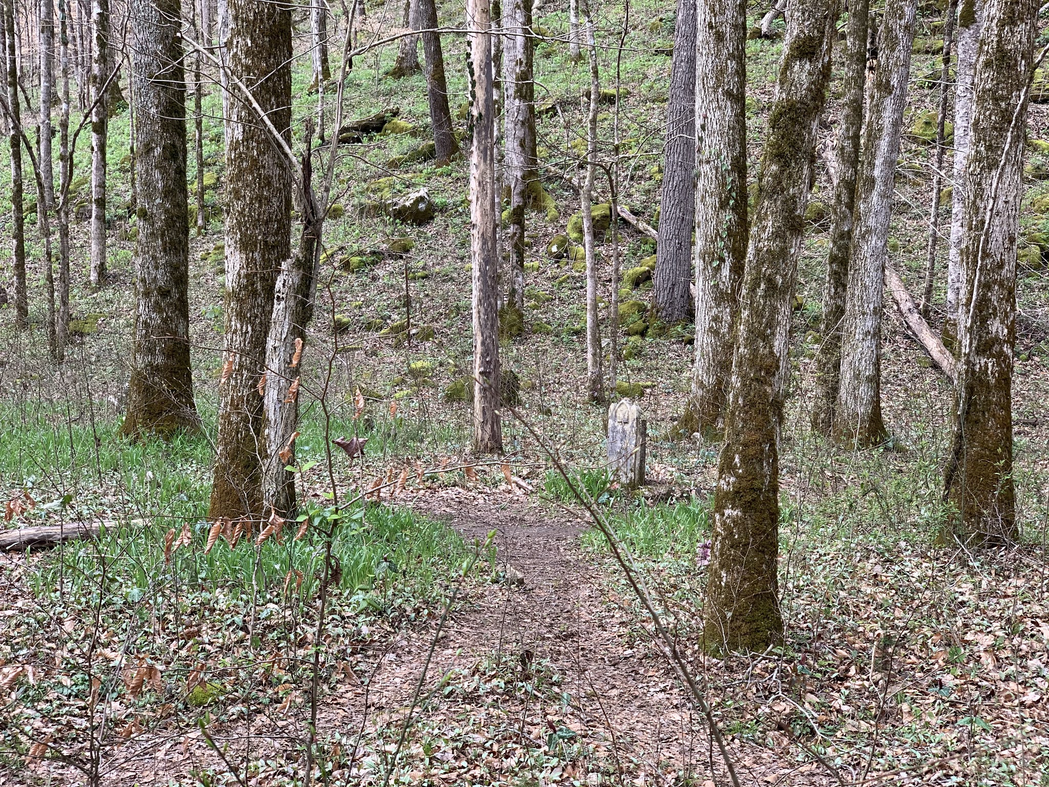
The area on the far side of the creek is a large open clearing with several obvious campsites and another steep rocky hill climbing to form the western side of the valley. As I look at these sites, I consider the idea of leading the Meetup group on an overnight trip to this area in the early fall perhaps. It's something to think about, at least. Another trail junction presents itself with a sign labeled South Rim Trail pointing up the hill, though after researching I'm unable to identify this other trail. No matter - it's not the way I'm going today.


Just past the junction, an old family cemetery is in disrepair. I don't know much about the family that rests here, but it is labeled Clark Cemetery. At the very least, they have an absolutely beautiful area to spend eternity. From here though, the trail gets more challenging as it climbs up the tall canyon formed by Turkey Creek.


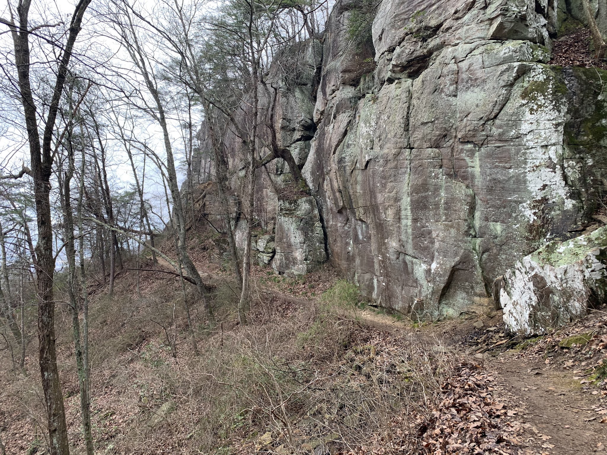
Unlike the gentle sloping hills above Hurricane Creek, this section is a deep canyon cut into tall limestone cliffs on either side. The creek passes serenely below, but the narrow trail rises and dips on it's ascent up the canyon. Several places are quite slick and a misstep would likely result in my falling a couple of dozen feet down the steep and muddy hillside to the cold waters below. I take my time and use my poles wisely to ensure I have good footing as I make my way. I'm generally not a fan of trekking poles, but there are some places where they can come in handy - this is one of them.

After about half-a-mile, I reach a series of low cascading waterfalls, where the coloration of the water and the limestone present almost like marble. It's breathtaking. And beyond, I can see the lowest of the waterfalls for which this area is so renown. To get there and beyond though, I will have to cross the creek. Planning for this eventuality, I had brought along my water shoes, which I now change into. The creek is shallow, but the waters are pretty frigid. I'm able to make my way across the first section easily and then onto the center island before crossing the next section, which is slightly deeper, but still well below my knees. From here, I have to climb up a steep embankment and then curl around the bend to reach the money shot.

Before me now lies one of the most gorgeous natural scenes I have ever seen (and I've seen a lot). A limestone basin has been carved out of the hillside by the rushing creek. A dry waterfall passes over the top, but to the left of it water rages out of a hole in the canyon wall forming the second waterfall. I spend some time exploring this area. It's absolutely stunning and great fun to walk around, though anyone visiting should be careful here. One wrong step could send you plummeting over the falls. This water is shooting out with a lot of force. As I walk across the dry falls, I consider climbing up to see what lies above, but as it is dry and I assume the water coming from the hole in the canyon is coming in from far above, I decide to avoid the slightly dangerous climb. 

I make my way back across the creek and change back into my hiking shoes before enjoying a Clif bar and some water. Time to head back. The trail seems easier and less dangerous going back down the canyon, but this is likely to my having just done it on the way up. As I cross back over Hurricane Creek, I come up on a couple that I had encountered at the waterfalls. They had decided to climb the dry one and inform me that there is a third waterfall beyond there pouring into a hole in the limestone, which is presumably the source of the second waterfall coming out of the cliff. Damn!! I should have climbed up there. That said though, it gives me one more reason to return here, though I will probably take the Tennessee trailhead next time just to see another section.

The return trip is uneventful, though a good workout as I make my way back up the long hillside. As I'm training for an upcoming backpacking trip in the Grand Canyon, I try to maintain a fairly fast pace up hill. It feels good. Finally reaching my jeep, I check in on my distance and see that I've covered about 8.3 miles and gained/lost over 2,100' of elevation. The Alltrails description is a bit off on this one, but that's okay, it was a fabulous hike and I will return to this place someday in the near future.


Sunday, March 14, 2021

Lake Lanier - Peninsula Hike (Gwinnett County, Georgia)

It's been quite a weekend already and I'm not done yet. Yesterday, I mountain-biked, hiked, and kayaked up in Chattanooga and this morning already, I ran a Pi Day 5k race (March 14th ~ 3.14). Now, it's time to get some more trail miles in with the Meetup group. Our organizer specifically planned today's hike to show me some of the great trails leading out onto the some of the peninsulas on Lake Lanier.

Our large group meets at the Bowman's Island parking lot below Buford Dam, but due to some confusion, we have to wait for others that went to the wrong parking lot to arrive. Though departing a few minutes later than planned, we hit the trail pretty quickly after our round of introductions. 

The first section takes across the dam and up the steep incline of the Laurel Ridge Trail in order to get us up to lake level, but from here the trails will be mostly flat until we descend back down this ridge at the end of the hike. There are a few people out today, but the trails are not really overcrowded, save our large group. We twist and turn with the trail as it visits a couple of the sprawling peninsulas pointed out into the large man-made lake. The trail is well maintained and the views of the lake are terrific on this sunny day.

As we note the time, we start to head back towards the parking area taking a slightly different route, which includes some road walking. We quickly arrive back a the cars and wish each other well, after having hiked an easy 8.8 miles. Many of the members are going for dinner, but as for me, I'm going to go home and relax. It's been a very active weekend and I think my body needs some time to recuperate. 

Saturday, March 13, 2021

Downtown Chattanooga Sunset Kayak Tour (Hamilton County, Tennessee)


My final stop for the day in Chattanooga takes me back out onto a Kayak to leisurely paddle down the Tennessee River at dusk. Meeting up with our REI guides, all of us choose our boats and life jackets, while they go over some basic safety information. Seeing these boats, some very similar to the one I sold before leaving Reno, just re-motivates me to purchase a new one. I honestly didn't realize that kayaking would be such a popular activity in Atlanta, but it's even more popular here than it was in Reno.

As this is intended to be a very slow paddle with the current of the river, I forgo using a spray-skirt and just jump in my boat as one of the guides gives me a push into the water. After everyone has launched, we begin our lazy trip down the wide river. We see some wildlife along the way, mostly cranes doing their best to find a meal in the shallow shoreline waters. The dam just above us was spilling a little water into this section of the river, giving us just a enough of a current to not require much paddling and still be able to maintain a nice speed. We do a little paddling though. 

It's nice and quite out here, even though we are within the city itself. The Tennessee River passes through downtown doing a couple of interesting bends as it snakes through, but we will only traverse one of these. As we continue on, I realize that I forgot to start my GPS track once again and will have to estimate the distance we travel.

As the sun sets in the west, I'm able to get some very nice views of it over downtown. There is still some cloud cover, but not enough to spoil the view. As night settles in, temperatures drop a little, but never to the point of getting cold.

Eventually, we make it back to our landing point and make our way back onto dry ground. I struggle to maneuver this 14.5 foot boat a little bit and require some help from the guides to get turned around correctly, but it's no matter and soon we say our goodbyes and head our separate ways. I estimate we paddled about 6.5 miles, but it was incredibly easy and a nice way to end the evening in a new city.

Sunset Rock via Bluff Trail (Hamilton County, Tennessee)

My next stop for my day in Chattanooga, TN takes me back up to the top of Lookout Mountain for a short hike. One of the other participants of the Mountain Bike Tour decided to join me, as we are also both doing some Kayaking with REI this evening. 

Starting at Point Park, which is appropriately named since it sets on the literal point of the mountainous finger overlooking the Chattanooga Valley, we quickly find the trail that leads to Sunset Rock along the Bluff Trail and begin our hike. Atop the mountain Civil War-era cannons remind visitors of the prominent role this mountain played in defending the south from Sherman's March.

This trail seems to be pretty popular, as there are quite a few hikers here, but I suspect the fog which sits on top of us and spoils the view has deterred some adventurers today. We push on regardless. The trail itself is pretty well maintained, though rocky in sections. Lookout Mountain, along which we are hiking the top of is really nothing more than a tall river bluff. Some sections seem great for climbers and no sooner do I think that to myself than we encounter some. They really aren't doing much more than bouldering, but they seem to be having fun.

Just as we pass the climbers, my companion gets hit by a small falling rock. We don't think it was the fault of the climbers, as it seemed to come from far above their location. That said though, it does seem to have hit between the shoulder blades and left a little "road rash", I'm sure it hurt, but she toughs it out and we continue on our hike. 

The final section to Sunset Rock itself consists of a large number of stone steps climbing back up the side of the bluff. The view from the top is well worth it though. From here, we can look out on the entire valley from far above. Luckily, the fog has clear a bit and we are able to take in the vista for a couple of minutes before heading back to the parking lot.

The return trip is uneventful, and luckily, we don't get hit by any more falling rocks. It was a nice little hike of 3.4 miles, but now it's time to head to the next adventure on the Tennessee River far below our present location.

Lookout Mountain Incline Railway Bike Tour and Micro Brews (Hamilton County, Tennessee)

Chattanooga, TN is a great little town just a couple hours away from my home near Atlanta. Since moving to this area, I've only passed through the town, but decided to spend some time here today. Luckily, REI offered a couple of interesting adventures around Chattanooga and I decided to take advantage of these opportunities and REI's gear. I'm not the biggest fan of Mountain Biking, but the chance to ride all downhill off of Lookout Mountain seemed like a fun one.

Meeting our guides a few minutes before the start time in the parking lot for the Lookout Mountain Incline Railway, we do a quick round of introductions and the guides explain our agenda. While two of them drive our bikes to the top of the mountain, the the remaining guide and the rest of us will ride the train car, which ascends the steep mountainside, to the top and then ride our mountain bikes back down. We then board the rail car, which is quite interesting. The car itself has been designed to sit at approximately 45-degrees and the floor is actually a set of steps, but sitting at the boarding platform on flat ground, it's just a little inconvenient. It seems this ride will reach a maximum incline of 72.7-degrees, making it one of the steepest passenger railways in the world. The ride to the top is smooth, but a little harrowing as we look down the mountain. On the incline itself, the interior of the car is essentially a staircase with seats on each side. It's actually a pretty cool experience, though brief, as we reach the top after only five minutes or so.

Departing the train car, we walk to a nearby grassy area, where we choose our bikes and helmets, while our guides provide a basic overview of the bike's operation and the route we will take. After some seat adjustments and other fine-tuning exercises, we take off. The first section, sees us hugging the side of the road as we share the lane with cars, but soon, we leave the paved road for a gravel and earthen mountain bike trail. As stated earlier, it's all down hill, which my legs appreciate. That said though, there are some sharp turns and lots of tree roots in places and I'm forced to take it easy. I'm not much of a mountain-biker and this fast course only furthers that point. We stop a couple of times to ensure everyone is keeping up and for a couple of nice views, but after about 45-minutes we have made our way all the way to the bottom.

As an additional part of the trip, we spend some time at The Tap House, a local craft beer establishment, and enjoy some snacks and beer on REI's tab. The ride down the hill was only about 6.9 miles, but it went really fast with all of the downhill. It was a fun event, but the day is still young and there is more adventure to be had.

Wednesday, March 10, 2021

Little Mulberry Trail (Gwinnett County, Georgia)


Forever looking for new trails to explore, I stumbled across a new park not far from house while reviewing some Google maps.Little Mulberry Park is only about a 20-minute drive from my home and has a fairly extensive trail system, though it seems much of it is paved. Still, it seems like something worth checking out on a weekday morning before starting work.

After parking my jeep, I start walking on a paved trail around the eastern end of the park. While it is very urban, it's gorgeous here. The trails are well maintained and even the grassy open areas are well trimmed. I'm surprised to see a huge number of earthworms out on the pavement writhing their way across it. This isn't an uncommon site after a rain, but it's been dry for days and there are a ton of these worms. Interesting. 

Leaving the paved area and heading off into the woods, I make my way down int a small valley, at the bottom of which is a small and tranquil waterfall. The pavement starts up again nearby and I find myself heading towards Miller Lake. The lake is actually kind of pretty, as the trees reflect off of the water's surface creating an almost mirror image. I walk around the dam a short distance before doubling back, but before I do, I come face to face with a large great blue heron, who seems blissfully unaware of me only a few yards away, as he intently watches the water below his feet for lunch.


The trail, now single track and dirt once again, heads steeply uphill and cuts through the woods. There seems to be a nice mix of paved and unpaved trails in this little regional park. After a short distance though, I'm back on pavement. As I come around to a juncture with the ravine trail, I walk down to the ravine overlook, which provides a decent view of a larger cascading waterfall, though it is only a dribble at this time. Unfortunately, several large trees obscure the view and I carefully make my way down the hill a little bit until I can get a better view.


Next stop, is the "old oak tree". This tree is thought to be more than a century old and provides evidence that this hillside, now densely forested, was a pasture sometime in the recent past. Barbed wire was found in the trunk of the tree, having been grown around. It's interesting to me that in such a heavily populated area as Atlanta, the history of such a field is lost to history. I could understand this more in my previous home of Nevada, given the vast distances between settlements, but here, we are in an very urbanized area that was seized and settled by Europeans more than three hundred and fifty years ago. 

From here, I make my way back to my jeep. I was able to hike about 4.3 miles this morning and this little nearby gem of a park and now it's time to get to work. I may have to return to the trails here though, as there are several that I don't have time to explore this morning.

Sunday, March 7, 2021

Arabia Mountain Wilderness Bushwhack (DeKalb County, Georgia)


I was kind of undecided on where I wanted to hike today. I had originally thought of driving up to northern Alabama to do some trails that have been on my checklist for a while, but after a busy day yesterday, I decided instead to join the Meetup for another hike at Arabia Mountain. The hike's organizer had discovered some trails in the woods east of the mountain itself last time he was here and wanted to explore them a bit.  I've hiked at Arabia Mountain several times since moving to Georgia, but usually around the granite monadnock. This would be an opportunity to explore the extensive wooded area around the mountain. Sounds like fun.

I got here a bit early in order to have a sandwich before hitting the trails, but soon I'm joined by other members of our group. As usual, we do a quick round of introductions before hitting the trail. Unlike most trips here, we do not walk the long boardwalk from the Heritage Center, where parked, to the southern face of the mountain, but instead almost immediately enter the woods. From here, we bushwhack a little bit until we find our way onto the northern end of the granite mountain. We spend a little time exploring around and discover a couple of interesting things, including the old armor where the quarry workers likely stored their explosive charges and the ruins of an old stone building on the edge of the woods. With its proximity to the quarried area of the mountain and the armory, it's likely that it was related to the quarry operations, but the truth is likely lost to history.

From here, we begin a long bushwhack into the woods east of the mountain. While much of the terrain is grown over, there are patches of solid granite for the extent of our journey. I knew there was a lot of it here, but I had no idea how vast of an area it actually covered. Our path forces us to do a couple of creek crossings, which provide a moderate challenge for some of the more inexperienced hikers, though we do our best to help them across the fallen logs that we use as bridges.

At one point, we stumble across a dilapidated deer stand in the woods. At the foot of the tree, in which it is built there are the remains of a large number of coyotes. Some are relatively fresh, while some are nothing more than piles of bones. I suspect the deer hunter eliminated these creatures as he encountered them. While I do understand how they can be a nuisance in urban areas, I hate seeing senseless killing of any creature.


Finally, we discover a network of wide trails. At first, I assume they were used by trucks to haul out loads of granite cut from the mountain, but there are no tracks and little sign of any usage at all, other than the fact that there is almost no dead fall along their lengths and they are well maintained. It's kind of strange and none of us can really figure out their purpose.

After exploring this area for a while, we end up road walking a short distance. While making our way around a sharp corner, we are witness to a car accident. A delivery van had signaled left turn into a drive way, while another car, traveling way too fast, attempted to cut in front of and around the van, blocking his turn. Instead, the car ended up colliding into a retaining wall and left the van wondering what had happened. Seeing the accident, I immediately burst into a sprint to see if I can help the individuals in the car. Though it is only a short distance, by the time I arrive, both driver and passenger have exited and seem to be fine. The airbags fired and likely protected them from injury. After ensuring their safety and that someone was contacting the police, we continue on our journey.

From here, we make the turn north onto Klondike Road and then enter a newly constructed sub-division before going back into the woods for more bushwhacking. The trails here definitely connect to those for Arabia Mountain; we just need to find them. Eventually we do, but by this time, many of our hikers are exhausted. We've already put in nearly 10 miles and still have some distance to go to return to our cars. That said though, there isn't really a shorter route from here. I hang towards the back and try to encourage some of the folks that are struggling. 

Eventually, we reach the parking lot and say our goodbyes. Our total distance was about 11.3 miles and speaking with some of the stragglers, it seems this was the longest hike they had ever completed. Good for them! While it was in an area that I have hiked a number of times, it was nice to find some new trails and new points of interest along the way.

Saturday, March 6, 2021

Raven Cliff Falls (White County, Georgia)


Since I've started leading hikes for the Meetup group here in Georgia, most of my the hikes that I've organized have been more challenging and definitely not for beginners, but I do recognize that some folks are just not up to doing 10+ miles on the trail. That said, I thought it would be nice to lead a less strenuous hike and encourage some of those members. Raven Cliff Falls near Helen, Georgia seemed an ideal location. This was one of the first hikes I did after moving to the Atlanta area and so, I know it's a pretty easy trail. Before the hike, I'm running a trail 5k at one of the nearby wineries, which in combination with the hike, should give me a decent workout for today.

The 5k was pretty strenuous as we run up and down the vineyard rows on the side of a steep hill, and so, I'm actually pretty glad I didn't schedule anything too crazy this afternoon. As expected the trail head parking lot is overflowing with cars, but I manage to find a spot to stash my jeep just a short distance away down a forest service road. 

As the large group begins to assemble, I initiate a round of introductions and explain a little bit about the Meetup group and today's hike. There are a lot of new faces, likely encouraged by my listing this as a "beginner's" hike. One of the other organizers has joined us and I ask if should be willing to either lead or sweep, and give her the choice. She ends up leading and I end up sweeping, which is fine by me.

The trail, as on my last visit, is well-kept and well-traveled. It follows Dodd Creek as we make our way to Raven Cliff and the waterfall that time has carved through it. Along the way, I help a few of the older hikers with some of the minor obstacles, but all in all, we make it to the base of the falls without incident.There, we take a few minutes to enjoy a snack and take in the gorgeous landscape and waterfall. 

After a short rest, I call the two minute warning and soon, we are back on the trail. Again, I sweep, while the other organizer leads us back towards the parking area. The return trip is uneventful as far as I can tell from the rear, but when we arrive back at the trailhead, I learn that our senior statesman got slapped in the forehead with a large tree limb. I ask him if I might examine him to ensure he doesn't have any sign of a concussion, which he agrees to. After talking with him a bit and doing a basic examine, it seem he is fine, but as a precaution, one of our other hikers is going to drive him home. All in all, it was a great leisurely hike of about 5.8 miles. Many of the members thank me for organizing and leading it and ask that I do more hikes of this type. I agree, but warn them that they will likely be few and far between, as I personally enjoy the more challenging stuff.