Saturday, January 30, 2021

Paces Mill to West Palisades (Cobb County, Georgia)

It's suppose to be a rain-soaked weekend and I was suppose to be hiking to and sleeping at the Len Foote Hike Inn this evening. I had hoped for a beautiful snowy setting on the way up, but with temperatures just a few degrees to warm, it's more than likely going to be a wet and muddy mess. I think I'm going to have to be content to get a few miles in this morning at another of the Chattahoochee River units. Today, I'm joining the Atlanta Outdoor Club to hike a few miles from Paces Mill.

The ten of us met at 8:00 sharp on this cool January morning. After a brief introduction, we hit the popular trail, which was being used by numerous hikers and runners. The first section is paved and quite wide, but we quickly depart the maintained pavement and enter the woods on a combination of gravel, earth, and old broken pavement. I think these were once urban roads prior to the Park Service's acquisition of the land. The trail has a number of nice hills, but I'm feeling great this morning and find myself climbing them without out breaking a sweat. As we make our way around the park and await the slower members of the group, we encounter some very brazen deer who don't seem to mind our presence much at all.

Returning to the parking lot along the river affords us the opportunity to get the best views. With the addition of a few little dead-ends, which the organizer included purposely, we are able to knock out almost exactly 6 miles. As it turns out, we followed a very similar path as a hike I did over the summer, but starting from the other end at West Palisades. Ah well, it was a nice way to spend the morning and probably the only hiking I'll be able to get in this weekend with a large storm moving in shortly.

Sunday, January 24, 2021

Cochran Mill (Fulton County, Georgia)


I had originally planned on exploring some areas in northern Alabama this morning, but I guess yesterday's kayaking took a little more out of me than I thought and I ended up sleeping in pretty late this morning; too late, in fact, to complete the trip I had originally planned. Still wanting to get some good exercise for my legs though, I decided to join one of the Meetup groups last minute to hike around Cochran Mill. This will be my second time exploring the trails of this park and in fact, this was the first Meetup hike I attended after moving to Georgia over a year ago. So, I guess you could say it's something of an anniversary.


The group assembles at the trailhead, and after a quick introduction, we hit the trail. Today's route will be the reverse direction from my previous visit and hit a section that I had not explore that day. The first point of interest includes the ruins of an old mill set atop a beautiful waterfall. We take a few minutes for pictures before moving on. 

After just another mile or so, we come to another interesting section that requires us to balance our way across a stone dam set atop a sheer sheet of granite which the waters race over creating a sheet-style waterfall. After crossing, I wait on the other side to assist those in the group dismounting the wall. Here again, there are signs of old construction. It seems this was a popular industrial area many decades ago.


From here our trail meanders back and forth through the woods and along the branches of Bear Creek. The waters of the wide-creek are mostly calm and the area is quite serene. There are a few small hills to conquer, but for the most part, this is an exceptionally easy hike.

As always, the group begins to splinter into several sub-groups as our paces work themselves out. Those of us that are faster usually wait at intersections for the slower members to ensure they end up going the correct way. We do encounter a few mountain bikes in the western section of the park, but overall, it's not nearly as busy as the parking lot would have lead me to believe. 

Regardless, it's a beautiful day to be out here enjoying the trails and good exercise for my legs. Making our way back to the parking lot, some of the Meetup members want to grab dinner at a nearby restaurant, but opt to head on home this time. I was able to get in about 10.8 miles today, which is pretty good and though it was easy hiking, it was quite enjoyable.

Saturday, January 23, 2021

Long Shoals (Pickens County, South Carolina)

Having had my legs stuffed in kayak for the last several hours, I thought it might be a good idea to stretch them a little bit before driving home. A small roadside park not too far from the lake offered just the place. Long Shoals is nothing more than a pull-off above Little Eastatoe Creek, but a trail leading down to the waterway gives me a chance to explore a long granite flume carved by the creek.

There isn't much to this place, but it is beautiful in its own right. The waters of the small creek flow over thick granite as they cascade down one section to the next and the next until finally reaching a calm clear section below. A young family is here as well and the children seem to be enjoying themselves under the watchful eyes of their parents. It's probably a good thing, as the waters here are flowing pretty fast in sections and could easily sweep one of the toddlers away.

I explore a few hundred feet of the mostly exposed shoal before heading back to my jeep. It was nice to get out and stretch a bit, but there really isn't much more to this place. It has served its purpose though and I'm ready for the drive home.

Waterfalls of Lake Jocassee Kayak Tour (Oconee County, South Carolina)

While living near Lake Tahoe, I bought a kayak and used in many times there and on other nearby lakes. However, I didn't think that kayaking destinations would be as readily available once I moved to Georgia and ended up selling my boat to a friend. As it turns out, kayaking is an even more popular sport here than in my former home. The many rivers and man-made lakes of the area offer a plethora of interesting waterways to explore. 

Since I'm considering getting back into the sport and purchasing another boat, I decided the prudent move would be to get a little exposure before spending all of that money, just to be sure I really wanted to involve myself in it again. To that end, I have signed up for a few excursions with REI over the next couple of months. Today, I'll be paddling on Lake Jocassee in the northwestern corner of South Carolina to explore some of the lake's waterfalls.

After getting checked with the rangers at Devils Fork State Park, I quickly locate my group and begin prepping my gear. Once the other participants arrive, our guides cover several discussion points including safety protocols for the pandemic, boat adjustments, and the day's agenda. It takes about an hour to get through all of the material and get ourselves and our boats ready to hit the water. Entering my borrowed boat, I opt for a method demonstrated by one of the guides that allows me to insert myself in the kayak from a landing without getting myself too wet. It takes a minute to get my stability, but the method worked pretty well. It takes a few minutes for all of us to get situated and on the water, but soon we're paddling our way around the shoreline of the lake.

I had forgotten just how fast these slim boats can be on flat water. Though, we go at a pretty leisurely pace most of the time, I'm able to get short bursts of speed as the eight members of our tour group sort of leap frog back and then ahead of each other as we work our way from one point to the next. For the most part, we stay within 100 or so yards of shore. The occasional waves add a little bit of excitement as there is always the possibility of tipping the boat and going for a swim in these cold waters. Luckily, the weather is cooperating nicely and though it isn't exactly warm, the combination of cool air and near constant activity, keeps us all pretty toasty.

*Photo courtesy of one of the other participants

Continuing around the lake, we reach an "island" that will probably not exist too much longer. This lake, like so many in the area, is the result of damming a confluence of four rivers back in the 1970's. Much of the topology of the area was drastically impacted by the rising waters. As I understand it from our guides, this island is often a peninsula, depending on water levels, but was obviously once just a high point of land above the river. Today, it offers and interesting place to take a short break. The waters around the earthen island or very clear and it's easy to estimate the depth. A few lonely trees remain on the island, but I suspect that once these trees see their final days and their root systems begin to decay, the island will crumble into the surrounding waters. 


Time to move. We begin our push towards the first of the waterfalls that we plan to visit. Our guides have led this trip many times and have a pretty good idea of what we can accomplish during our set duration based upon when we reach certain points along the trek. Unfortunately, we are moving pretty slow. One of the members, who had never been in a kayak before, is struggling a bit and slowing us down. That's fine though, this adventure is planned with beginners in mind. Given our time, we set a bearing for Bad Creek Falls and reach it a short time later. 

Being in a human-propelled craft like a kayak allows us to paddle right up to the tall waterfall. It's a pretty cool experience. It's set back in a little cove with bushes and trees covering the shoreline on either side. As we take turns paddling up to the spot the falling water hits the lake, the rest of us just pause in and around the little cove. Without doing any paddling though, the currents push us back into the bushes and I find myself having to occasionally maneuver may way out. Totally worth it though. 

After a while we had for a sister waterfall on the other side of the cove. This one is much less impressive, but still interesting. Again we take turns approaching the waterfall until everyone that wants to has had the opportunity. Shortly afterwards, we turn to head back the way we came. Somehow, I end up a little further out form the shoreline than my companions and take the opportunity to cut loose a little bit and really test the speed of this boat. It's a lot of fun.

As we pull back into the dock and de-boat ourselves, I think back on the day's adventure and I'm already pretty convinced that I want to buy another kayak and get back into the sport. While I didn't track our distance, though I meant to and simply forgot, I would estimate that we paddled approximately five miles along the shoreline of this beautiful lake. Perhaps, I'll return here again someday and find the other waterfalls our guides mentioned.

Wednesday, January 20, 2021

Cochran Shoals (Cobb County, Georgia)

Of all of the Chattahoochee River National Recreation Area's many units Cochran Shoals is said to be the most popular. It's also one of the few that I haven't visited yet since moving to Atlanta. With a couple of days of good weather and some free time before I have to start work this morning, I thought it would be nice to get out for a mid-week hike this morning. It's also the first time I've put in any real miles since running the half-marathon on Saturday. My legs have had a couple of days to recover and feel pretty good.


Arriving at the parking lot, the reputation as the busiest unit seems justified. There are already twenty or more cars here and several people are prepping for their morning runs, walks, rides on the park's many trails. As I depart the parking lot, the wide gravel and earth trail follows the river's shoreline and provides some nice views. The shallow water forms some very mellow rapids over the subsurface rocks.

There are a couple of wooden observation decks constructed to overlook the river. As I approach one, I see a large heron standing gloriously on the rail of the structure and overlooking his domain. Not wanting to disturb him, I take a couple of pictures and move on. Eventually, I take a side trail to double back the direction I came from, but on a slightly higher trail. There are a number of intersecting trails here, but as I have only a short time, I need to head back. After getting back to my jeep, I see I've hiked about 3.9 miles this morning, though with the ease of these trails, it was really more like a stroll along the river.

Sunday, January 17, 2021

Magnolia Springs (Jenkins County, Georgia)

My final stop on my way home from a weekend near Savannah, GA takes me to Magnolia Springs State Park, which is home to the largest natural spring in the state, pumping an estimated seven million gallons of crystal clear water each day. The park and springs are home to a variety of wildlife.

As I pull into the park in my jeep, I drive around to quickly get a lay of the land. I note a large man-made lake at the northern end of the park, but otherwise I am initially disappointed with what I'm seeing. Since I've diverted an hour or so out of my way to stop by the park, I want to ensure I give it a full measure of exploration and so, I park near a picnic area and start to walk around by the waters of the Spring Mill Branch of Buckhead Creek. This would turn out to be a wise decision.

Approaching the edge of the waters, I realize that this is the actual spring for which the park is named. The clear blue waters flow from a tunnel in the center of the creek and feed the flowing branch of the creek. A variety of creatures live here. From big mouth bass to soft shell turtles both swimming and sunning themselves on downed tree limbs, the pool around the spring is teeming with life.

I decide to walk along the creek for a ways and see if I can spot any alligators. Eventually, I find two four to five foot specimen both on the opposite shore sunning themselves and taking little note of me on this breeze winter day. The creek itself is quite beautiful with a palate of differentiating colors throughout. I'm extremely glad that I decided to explore a little bit instead of just driving off in disappointment. It turns out the park is well worth a visit. I will try to return in warmer temperatures to see the critters more active.

Wormsloe (Chatham County, Georgia)

My next stop on my way home from the Daufuskie Island Half-Marathon sees visiting Wormsloe. Many times, I've seen images of a long straight road lined on either side by hundreds of large evenly spaced live oaks with old man's beard dangling from the limbs. This image is the entrance to Wormsloe. The trees were planted around the turn of the 20th century and remain a popular subject of photographers to this day.


Back in the late 1730's and English colonist built the first structure on this site, a large, fortified dwelling made from tabby (a form of concrete using oyster shells) and was meant as a defensive position should the Spanish attack the area. After a short hike down the Avenue of Oaks, I head through the woods to the structure. Though only a few sections of wall remain, it's a remarkable site to see this kind of construction. Frank Lloyd Wright would be proud of the use of indigenous materials to create such a place.


From here, I head further into the property, which is somewhat confusingly referred to as a plantation. After a little research, it seems the estate did once serve as a small plantation, but the structures associated with that time are still inhabited by descendants of the original owners and not open to the public. Just beyond the ruins of the tabby house, a wooden observation deck has been constructed to allow visitors to look out on the seemingly endless salt-water marshes that constitute the southern border of the property. I would imagine this marsh is full of amphibious life such as turtles and alligators, but it's probably a little to cold for them to be active today. Regardless, I'm not going for a swim here anytime soon. Just a short distance beyond the deck, a small colonial-style dwelling has been reconstructed, complete with an outdoor bread oven and blacksmith's forge. Apparently, re-enactments of colonial life are sometimes performed here, but I would imagine those performances have been temporarily cancelled in lieu of the pandemic.

From here, I take a parallel trail back to the parking area, having walked approximately a mile-and-a-half. It's a very interesting site with a rich history. If you're ever in the area, it's worth a peek.

Fort Pulaski (Chatham County, Georgia)

Savannah, Georgia is a city rich in history. Founded in 1733 as a British capital of the province of Georgia, the city has seen tumultuous times during both the Revolutionary War and American Civil War. Perhaps none so interesting as the battle that saw the fall of Fort Pulaski to Union forces in April of 1862. After giving my legs time to recover from the half-marathon yesterday morning, I decided to do a little exploration of this historical place.

The fort is now a national monument and has been partially restored after a long abandonment. As I walk around the front of the fort, I'm taken by how sound it appears to be defensively. Surrounded by marshes on all sides and protected by a wide moat with only a single entry point, the fort looks impregnable. Cannon batteries line the interior walls and the ramparts above cover attacks from any direction. 


As I enter the facility across the draw bridge, I see a small city inside, complete with an open plaza where garrisoned soldiers once played baseball during their downtime before the war. As I explore, I encounter a park ranger who describes the battle in detail to me and suggests that I should also walk around the exterior of the fort and see the damage for myself.

After completing the inner loop, I follow his advice and take a stroll along the grassy hills outside the moat. While there is a little damage here and there to the eleven-foot thick brick external wall of the fort, I see nothing substantial . . . until I reach the southeastern wall, that is. Here, numerous shells have bombarded the brick wall and destroyed chunks of it. As I understand it, the fort fell to new technology. No large artillery was thought to be able to be placed within in range of the fort due to the marsh, but the designers didn't count on the rifled barrels of the Union's newest cannons. This rifling adds spin to the projectile as it leaves the cannon in and explosion of gunpowder and the spin adds accuracy and substantial distance to the cannon's range. In fact these shots were fired from between one and two miles away from artillery on the distant Tybee island. Some of the shells remain buried in the wall.

As I understand it, the distant battering of this wall lasted thirty hours with over five thousand shells fire until this wall, later repaired by the occupying Union troops, fell and exposed the fort's ammunition stores to further impacts. The commanding officer fearing the explosions that would end his troops, surrendered to enemy forces by raising a white flag, thus proving the impressive fort pregnable. It's a good reminder to not be too sure of yourself, human ingenuity can go along way to making the impossible possible.

Saturday, January 16, 2021

Daufuskie Island Half-Marathon (Beaufort County, South Carolina

Between moving my family from Reno to Atlanta and the COVID-19 pandemic, it has been nearly seventeen months since I last ran a foot race. I had been getting out for morning or lunch runs along my neighborhood streets occasionally, but then I fell and broke my finger on one of those runs back in mid-October and hadn't run since. All of that gave me a lot of trepidation about accepting a last minute spot in the Daufuskie Island Half-Marathon. I had signed up for the race over the summer and had full intention of running, but it, but the available spots were very limited due to the ongoing pandemic and I was forced to join the wait list. I had essentially forgotten about it when the email came offering me a spot. I debated forgetting about it, but as my finger is now fully healed and I need something in front of me to get me motivated to run again, I decided to go ahead with it even though I knew my time would be far off of my PR set over a year ago. 

Daufuskie Island is the southernmost barrier island of South Carolina. The private island is just a few miles north of Savannah, Georgia and can only be reached by ferry. No bridges exist. Having never been there or to Savannah before, I thought it would make a nice weekend get-away. I left work a bit early on Friday evening and drove down to Hilton Head Island, immediately north of Duafuskie and the site of the ferry departure. As it was late, I checked into my very nice accommodations and quickly fell asleep, knowing I had to rise early in the morning to catch the ferry.

Though, I got up a and ready to race early, some confusion on my part regarding the ferry departure location had me arriving at the check-in with only a couple of minutes to spare before the last boat departed. I had considered wearing just running shorts this morning, but thought better of it and I'm glad I did. The cold winds blowing off of the Atlantic Ocean make it feel around twenty degrees this morning, though the mercury shows ten or so degrees warmer. On the open waters between islands, there is nothing to stop the wind and I do my best to stay warm. The event organizers and ferry operators have put strict guidelines in place for wearing masks and social distancing, which I'm very glad to see. I'm also ecstatic that all of the participants seem to be following the guidelines.

Arriving at the island, I pick up my bib and find the line for the port-o-potties before heading over to the start. Unlike many races that have a strict start time, the organizers have a start window to help with social distancing. We are allowed to start any time between 9:30 and 9:45. As we are all chipped and timing is automatically collected as we pass over the electronic detection devices, it has no impact on a runner's overall time. It seems to work pretty well and all of the runners, including myself, are able to spread themselves out pretty evenly to avoid close contact.

I feel pretty strong the first mile as we run through some of the colonial inspired neighborhoods on the northern end of the island. I've made a personal commitment to run at least the first five miles, after which my body will dictate if I'm able to run further or walk. The scenery here is gorgeous and it seems that all of the inhabitants of the island get around via golf-cart and down even own normal cars here on the island. Okay, that's proven incorrect a short time later as I encounter real cars, but only a very few. I do see dozens and dozens of golf-carts though. Some people even have cart-sized garages built into their homes. The giant live oaks dot the grounds of these mansions and old man's beard drape from almost every limb.

The race route follows mostly paved roads, but here are a few sections that are hard-packed ocean sand. I've run on beaches before and found it very difficult, but this is packed densely enough to feel much more like dirt and doesn't really offer any difficulties. Our path follows several interconnected loops in and around the island, exploring much of it. As we move further south, we enter a much less expensive area of run-down homes and trailers. Presumably, these are the descendants of much earlier inhabitants. As I pass the five mile marker, I'm still feeling pretty good and decide to push myself further. I pass the six-mile marker and continue on towards the seven. Shortly before the seven, I'm forced to reduce my pace and even walk a little bit. I'm feeling pretty taxed and my knees are complaining a bit. The pressure supports I'm wearing around my knees seem to help as the pain is not a searing pain as I have experienced before, but it still aches and will force me to slow down the remainder of the race.

As I approach the eastern shore of the island, the paved trail follows a long section of shoreline, complete with millions of oyster and other shellfish remains littering the narrow beach. In the distance, the sun rises high over the eastern horizon. It's quite beautiful and really makes a race like this worth it.


With only a couple more miles to go, I try to run a few sections off and on, but my knees are really sore now and as I approach the finish line, I decide to ignore them and finish strong. I run under the finishing arch with a time of 2:48:31, which is much slower than my PR of 1:58:55, but I promised myself I would be happy with anything under three hours and so, I am content. As one of the volunteers hands me completion medal and motions for me to head over to the lunch spot, I'm both disappointed and proud at the same time. I won't beat myself up too much though. Running a half is always tough, regardless of ones age and after so long on the bench, I'm just happy to have been able to participate and finish.

I grab a complimentary beer and lunch packet before finding a table. Setting across from a very nice older woman, we share our aches and pains, but congratulate each other on our accomplishment. She seems extremely nice. As I enjoy my sandwich, several friends congratulate me on social media and express their jealousy of my being able to run a non-virtual race. I hope I followed safety protocols closely enough and didn't endanger myself or anyone else, but it is really, really nice to be able to race again.

Saturday, January 9, 2021

Black Rock Mountain - James Edmond, Ada-Hi Falls, and Tennessee Rock Trails (Rabun County, Georgia)


I'm leading another Meetup group today. This time we'll hike the trails of Black Rock Mountain State Park near the Georgia-North Carolina border and Georgia's highest-altitude state park. I always like to arrive early when I'm leading and as I drive up the mountain, I'm a bit surprised to see snow and ice along the roadside. We've had a lot of rain in Atlanta over the last few days, but I wasn't expecting this. It may add some challenges to our outing.

As we approach the 10:00 AM start time I designated, several hikers begin to arrive. As we congregate in a picnic area at the confluence of the three trails we'll be hiking today, we all comment on the cold temperatures. The Georgia humidity and cold winds make it feel 10-15 degrees colder than the mercury reading, which currently shows 30°. We do a quick round of introductions, as usual, and then the nine of us are off.

This is my first visit to this park and I listed it as an exploratory hike, meaning there may be some level of route-finding as we make our way. That said though, I did review the trails pretty thoroughly before organizing the event. My plan is to link together two loop trails and one short out and back into a solid day of hiking. All three trails depart from this trailhead thus allowing people to skip one or both of the later hikes if they so choose. First we'll do the 7.5ish mile James Edmonds Trail, followed by a short out-and-back to Ada-Hi Falls, and then finally, we'll hike up to the crown of the park and summit of Black Rock Mountain along the Tennessee Rock Trail.

We almost immediately start hitting some snow covered sections on the trail and while it's not deep (only an inch or so at most) the melting and refreezing combined with the compression of the the footsteps of previous hikers has turned it into a slalom in places. I had hoped and even advised the group of keeping a 2.5 mph pace, but I don't want anyone getting hurt, which forces us to go a bit slower in places. It's the right decision though.

While many sections are covered with ice and snow, those areas in direct sunlight are something of a muddy, slippery mess and I am actually the first to go down. Though I land softly without any injury, other than my pride, it's a good warning to the whole group of the need to take our time on these slippery sections.

The trail itself is relatively easy to follow and the orange blazes on trees make navigation pretty simple. The trail splits and rejoins a couple of times, but we eventually reach the eastern most section and Lookout Mountain, which offers some outstanding views of the valleys to the northwest. We pause for a couple of minutes to take pictures before proceeding on.


As we drop down to the parking lot area for Black Rock Lake, I suggest it is a good place for a short snack break. The parking lot is surrounded by a set of low wooden barriers, which provide an ideal place to sit while we consume a few calories. From here, we take a short detour around the lake itself. This section is nearly flat, but some of the muddiest parts of the trail we've seen to this point. 


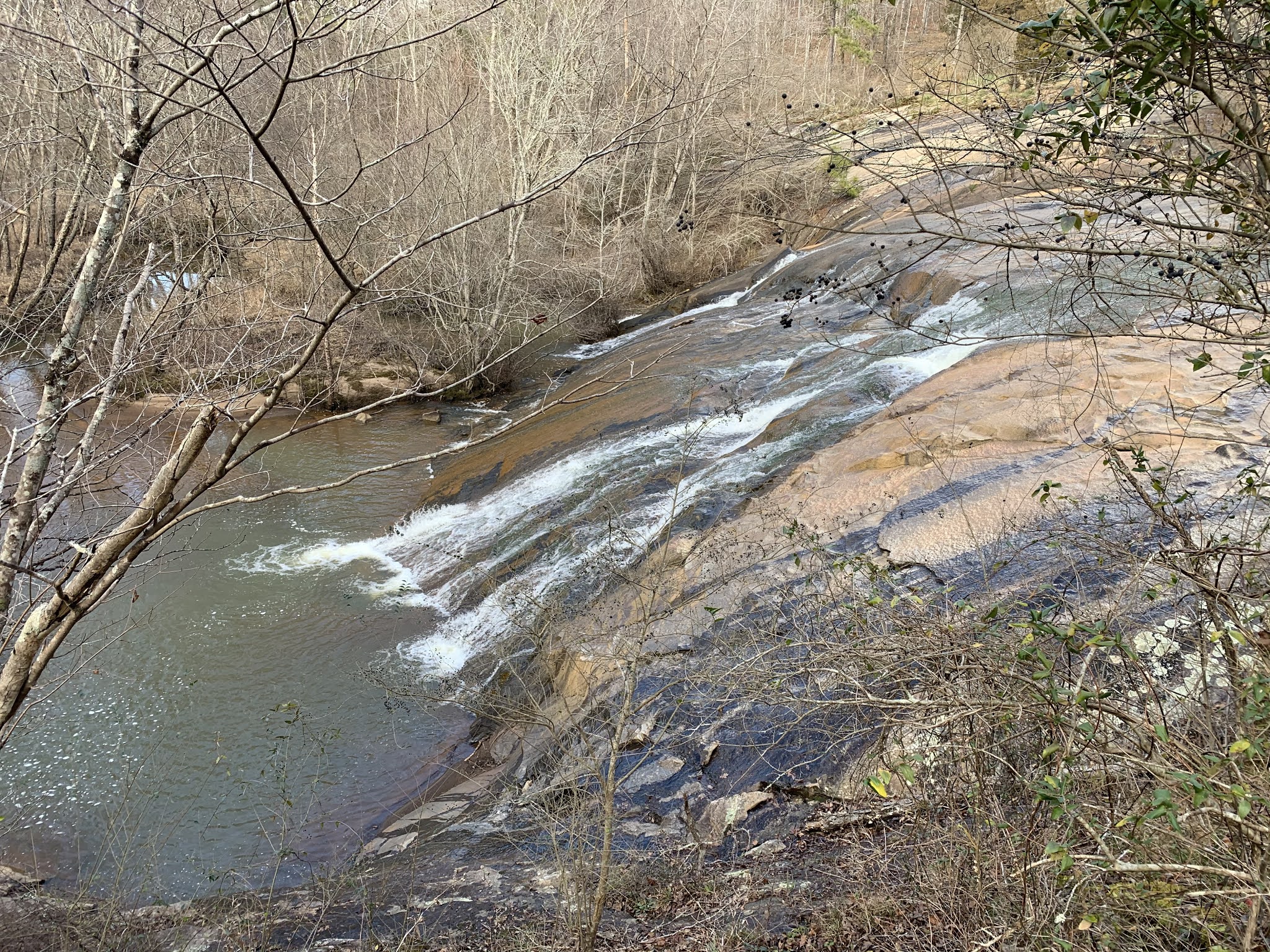
Returning to the Edmonds Trail, we begin the slow climb back up to the parking lot, passing a couple of nice waterfalls along the way. One of the hikers begins falling a bit behind and another, whom I have hiked with several times and I know to be very capable, offers to hang back with him. I truly appreciate her offer and those of us in the front continue on back to the parking lot. Once there we stop for a few minutes waiting for the others to join us, but we get a text message telling us to go onto the waterfall without them, as they are quite a ways behind. 

Six of the original nine walk along the Springhouse trail towards Ada-Hi Falls. This trail is similarly covered with snow and ice and one particular section with a large downed tree forces us to use our Ninja-warrior skills, but we make it past without injury. Dropping down to the park campground, we then reach several sets of wooden stairs descending down to the waterfall. They are ice-covered and I warn the group to take it very slow. It takes us a while, but everyone makes it to the observation deck without anyone falling.


Ada-Hi Falls itself is less impressive than I had hoped. It's a small stream fanning out over a large cliff. A few small icicles have formed, but being near the top of the the mountain, I assume there isn't a great deal of water available to flow over the cliff and so, it appears somewhat anti-climactic. It was still nice to see though. We take a few pictures and then head back the way we can, again being extra cautious on the icy staircases.

Once we reach the parking lot again, four more hikers decide to call it a day, leaving just myself and one other to complete the final trail, Tennessee Rock Trail. This is the highest trail of the three, but only about 2.2 miles. Still, the mud and ice are at their worst here and we are forced to take it even slower in places. Reaching the Tennessee Rock Overlook, we take a break to get some pictures. On a clear day, like today, it is said one can see into Tennessee, North and South Carolina from this viewpoint and I believe it. The green-ish brown rolling hills and mountains continue on as far as the eye can see in all directions before us.


Eventually, we reach the summit of Black Rock Mountain. At 3,640', it is the highest point in the park. As we take in our accomplishment, two F18-Hornets buzz by overhead. The sound of the jet engines is nearly deafening even at this range. We continue along the loop dropping down a couple of hundred feet to the return trail. This part of the trail is on the north side of the mountain and gets far less sunlight during the day. It is by far, the iciest and slickest section we have hiked all day. I slip several times, but never completely loose my footing. We are forced to move at a snail's pace though over several sections.

Finally make it back to the parking lot, I thank the last hiker for joining me on this adventure and head to my jeep to put on some fresh cloths, as the ones I have on are a sweaty, muddy mess and I have a ninety minute drive before I get home. My GPS app shows that we've hiked 12.2 miles with right around 2,750 of elevation gain and loss. That's a pretty good day in my mind.

Sunday, January 3, 2021

Gahuti Trail in Winter (Murray County, Georgia)

Not living in the desert or mountains any longer has slightly changed my perspective on repeating hikes. Generally speaking, I don't like to do a hike once I've already completed it. There are far too many other trails out there that I want to explore to see repeats. That said though, living where deciduous trees are dominant, the trails can take on a drastically different character between the seasons. For my first hike of the new year, I decided to join one of the Meetup groups I hike with often to explore the Gahuti Trail at Fort Mountain State Park in northern Georgia.

I had originally planned to do a couple of shorter hikes up this way prior to joining the group, but some overzealous hunters and my desire to not be mistaken for a deer and shot, forced me to abandon that plan and get to the trailhead extremely early. I took a nap in my jeep on this cold morning, while waiting for the others to arrive. While I was waiting, the owner of the group and organizer of today's hike called and asked if I would mind leading the group today in his absence. He hurt his back and wasn't excited about hike 8-10 miles on a somewhat challenging trail if he didn't have to. As I've lead a couple of recent hikes for the group, I was happy to fill in.

As the noon start time approached, I left the warmth of my jeep and headed to the meeting spot. It's much colder than I expected this morning - hovering around the freezing mark. After a few minutes, the others begin to arrive. By start time, there are seven of us ready to go. Since I have the luxury of data service here, I check for any last minute messages and note that one participant had posted that she was running 30 minutes late, but asked us not to wait on her. I appreciate that.

After a round of our customary introductions and a brief overview of the park and trail we are going to do, we get to the business at hand. The benefit of starting near the highest point of the trail is that it's all downhill for a while. Of course, we will have to get that elevation back on the return.

I decided to do this trail counterclockwise today as opposed to the clockwise route we took when I hiked here over the summer. Between the direction switch and the trees having shed their leaves, it looks like a completely different trail. We had some heavy rains just a couple of days ago and the small creeks are flowing like crazy. The trail is also somewhat muddy in areas, but nothing to terrible and it doesn't really pose any issues except on the steep downhills and uphills.

As begin pushing a pretty good pace, a couple of the hikers start falling behind a bit. We wait for them to catch up and when they do, they indicate that we should not wait on them and that they are fine on their own if we get too far ahead. I've hiked with one of them before and I know she's fairly capable and so after confirming, the group essentially breaks in two - a faster group and a slower group.

Making our way around the mountainsides that constitute the park, we cross over a couple of great waterfalls that I really have no memory of seeing before, but as I have hiked this trail in the past, I must have. I assume the water just wasn't flowing enough last time to make them memorable. We take a couple of minutes to take some nice pictures, but of course, every few steps we find a better angle and the whole affair turns into a five-minute ordeal - totally my fault.


The trails are littered with a number of downed trees - not just a couple, but dozens. It does make for some interesting Ninja Warrior-type moves occasionally, but definitely makes the trail more interesting. As we begin the ascent back up the the trailhead, I admit that my legs are starting to complain, but I did hike over 17 miles two days ago and then run 5 miles yesterday. I suppose they have a right to complain.

Finally, we reach the Cool Springs Overlook near the trailhead. We take a couple of minutes to absorb the great view from this point and then walk the remainder of our mileage on the park road back to our cars - just fifty yards or so. I wish the group well and thank them for coming out. A couple of us take a trip up the steps to the actual namesake of the park, the Native American Fort Wall that was built centuries ago. It's a quick diversion and I'm back at my jeep in no time with a total of 8.9 miles hiked.