Saturday, July 29, 2017

Lyell Canyon (Yosemite National Park, California)


Generally speaking my backpacking trips have not gone to plan this year. Be it weather, regulation, or just unforeseen timing issues, I have not been able to complete any of the six or so trips I had planned for this year as I had planned them. And while I have been able to do a great many hikes and see some beautiful country, it would be nice to have something work out as it was planned.

I have explored quite a lot of Yosemite National Park in the many years I have lived in Reno, but one area I had not visited was Lyell Canyon. Originally, my buddy bill was going to join me for this quick overnight trip, but he was forced to work and when I offered up the vacated backcountry permit, another friend, Nick E. quick spoke up and asked to join me. I was actually not aware that Nick enjoyed backpacking and as it turns out, he really hasn't had much experience doing it, though he has camped a hiked a lot.

In order to claim the reservation I had made some months ago we needed to arrive at the backcountry office prior to 10 AM and so we left Reno about 6 AM, with the intention of making a traditional stop for breakfast at the Whoa Nelli Deli, the best gas station food on the planet. We entered the park, grabbed our permits, and were on the trail by 10 AM. I couldn't help but laugh as fellow hikers/backpackers looked at Nick's rig in amazement. He had a nice pack, but attached to the back of it, his sleep bag was at least as large as the rest of his pack, making for a protrusion approximately 3 feet out from his back. It was quite amusing.


The trail is really well maintained and as we passed over some of the bridges near the trail head, I was thankful that the reports I had read were outdated. I had imagined and prepared for several creek crossings at this early part of the hike. The appearance of the bridges over Lyell Creek were a pleasant surprise in a year that saw record precipitation in the Sierra Nevadas.


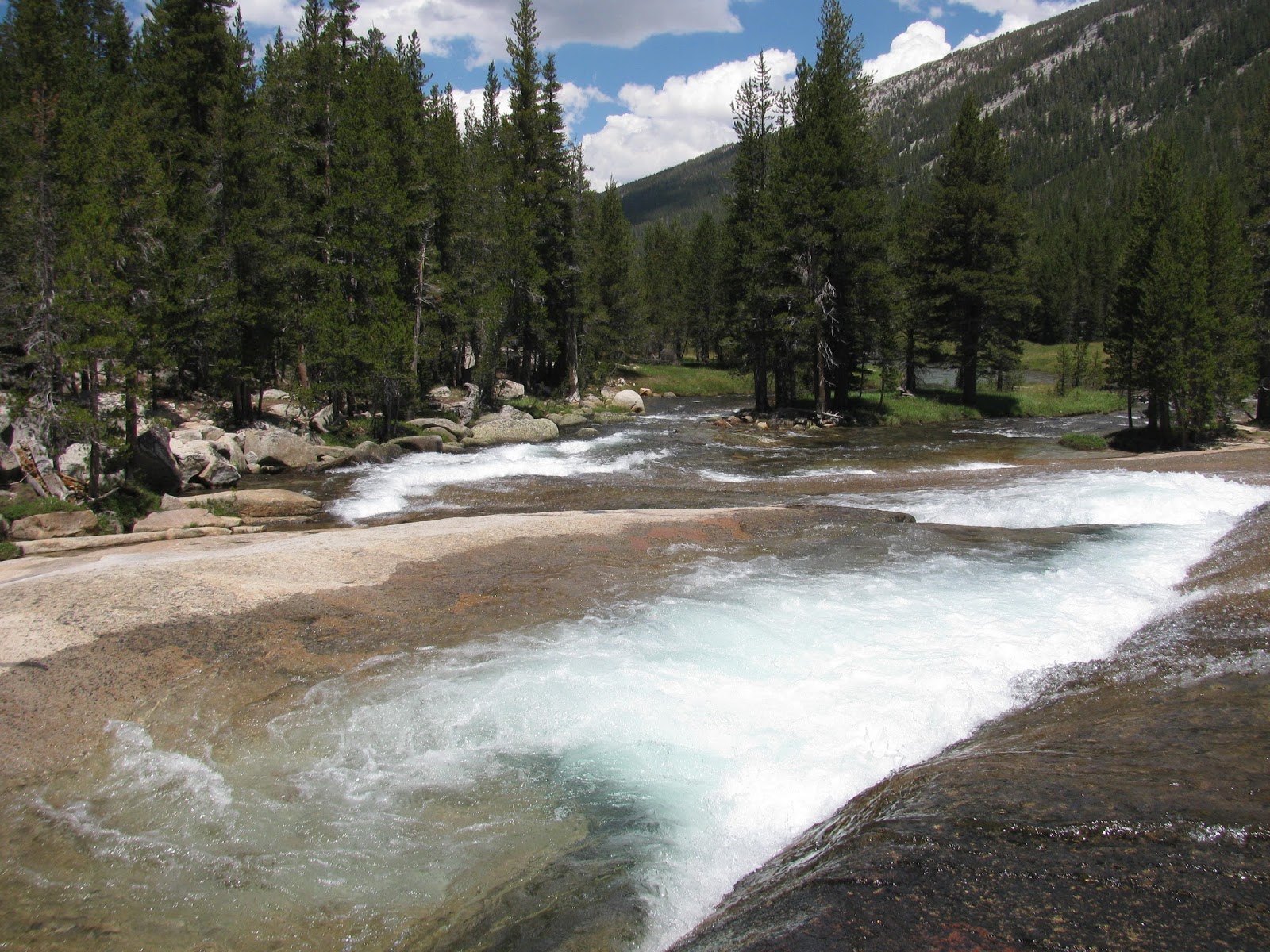
As far as hikes go, this was a relatively easy one with little elevation change as we follow the wide canyon cut by Lyell Creek several miles towards Donahue Pass. The creek flows as sheets of water of numerous granite slabs and outcroppings. Nick and I take some time to explore a bit as we follow the blue waters of the wide creek. I'm not actually sure where the Lyell Creek becomes the Tuolumne River, but to the casual observer, they would appear to be one in the same, both on the map and in person.


Looking far down the valley, we can see the only glaciers remaining in Yosemite National Park at the edge of Donahue Pass. We toy with the idea of hiking that far, but I'm really looking forward to a relaxing weekend and so we, stop well short of the switchbacks leading up and over the pass on the John Muir Trail. I really want to through hike that trail someday, but not today.

Finding a nice clearing, we begin to set up camp. Previous inhabitants have nicely arranged a fire pit and cleared out some areas for tents, which Nick and I take full advantage of. Truly, this is an amazing campsite. We are sheltered from the wind by the small trees. No 'widow-makers' loom overhead to fall on us as we sleep. The creek is only 100 or so yards away and provides not only a terrific water source, but a small nearby waterfall provides wonderful backcountry background noise. There's plenty of fallen/decaying logs to fuel our campfire. It's pretty much perfect.


As I scout the area, I discover the nearly-clean remains of a small dear only 20 or so yards from our tents. It's a dark reminder of the wild country that we are in. Nick and I pass the evening hours discussing life, the universe, and everything as we slowly feed our campfire and look forward to a restful nights sleep under the stars. 


When we wake, it's cold - probably around 45 degrees. We make some breakfast and begin to breakdown camp before heading out. The trip back is as peaceful as the trip in with only a few muddy sections and one or two water crossings to distract from the incredibly relaxing experience. I ask Nick how he liked back packing and he comments on what an amazing weekend it has been. 

Returning to the jeep, we use some wet-wipes to clean the sweat from ourselves before putting on fresh clothes and heading for home. In all, we traveled about 16.2 miles. For anyone looking for a great 'beginners' backpacking trip, I would highly recommend this one.

Sunday, July 23, 2017

Lands End (San Francisco County, California)


Never one to know when to quit, I decided to check out another trail after the half-marathon this morning. Lands End is the rockiest and most treacherous section of coast along the San Francisco Peninsula. Stories tell of numerous sunken ships in the waters of this area.

Finding a parking spot in the popular area, I decide to put on a light jacket as the cold fog is still present and each wave of the ocean brings with it more cold air. The trail forms a loop around the park, but as I want to get home at a reasonable time, I elect to only do a small portion of the trail and then hike back out. 


From the way they appear to be battered, I'd wager the trees in this area have seen some terrible storms coming in from the broad ocean before us. The trail is dirt, but well maintained and leads down steeply to a small overlook with an accessible beach below. In the angry ocean before us, great pillars of rock rise from and are eternally battered by the waves. 

As I reach the top of the overlook, I find something of interest that I had read about. On a large flat area of the natural overlook, someone has formed a circular labyrinth from local stones. A number of visitors attempt to find their way out of the feature. It's actually a pretty cool idea and while I don't actually enter it, I do enjoy watching others get lost in the maze.


After a few minutes, I decide to head back to the jeep. I still have a long drive ahead of me to get home to Reno and besides, I think my legs have had enough exercise this day. The short trail was only about 1.3 miles with the path I chose. It seems I'm getting in a habit of short hikes after long runs.

San Francisco Marathon - 1st Half (San Francisco County, California)


Since Iv'e gotten into running over the last few years, I've tried to make it a point to only do big runs when they are in a scenic area (Tahoe, Death Valley, Napa, etc.) and when I learned of the San Francisco Marathon, I couldn't resist the chance to run across the Golden Gate Bridge as part of the first half.

As the 5:30 start time approached, nearly 27,000 runners (combined marathoners and half-marathoners) began to line up along the Embarcadero. I've never seen so many runners in one place at one time. It's like a sea of runners here. So much so, that they start us out in pre-assigned waves spread 5-10 minutes apart. The organization of the race seems pretty good, but dealing with so many people has to be a logistical nightmare. 


As my wave's start time arrives, we run through the inflated arch and begin the long 13.1 mile trek to the finish line. Runners of all paces are in the group and push themselves forward as we make our way pass the piers of the bay.

As we arrive at the bridge, the fog is so think it's occasionally condensing into a rain drop and battering us on our sweaty heads. Running across the bridge, which has been limited to one way traffic (southbound) to accommodate the race, the tall red towers of the iconic bridge can only be seen when we are nearly right at them. As we arrive at the other side, I take advantage of the restrooms and hydration stations. With so many runners, the lines for the restrooms are very long and add significant minutes (15-ish) to my final time. No sooner do my feet start moving again then are we headed the opposite direction across the bridge. Apparently, this is a highlight and popular attraction of the race.

Finally, arriving at the finish line I'm greeted with a mylar blanket, a bottle of water, a banana, and my finisher's medal. This is my fourth half-marathon and I think the distance suits me. While I didn't set any records with my time, I enjoyed myself and will likely run this one again.

Saturday, July 22, 2017

Dipsea Trail (Marin County, California)


A weekend in San Francisco is always a treat and while I don't think I would ever want to live in such a densely populated area, I certainly do enjoy a visit occasionally. The food, the culture, the ambiance all make it a great experience. My primary purpose for this trip was to run the first half of the San Francisco Marathon, but while here I had to get in a little hiking as well. First trail to conquer? The famous Dipsea Trail that starts in Mill Valley (though, I'm starting it in Muir Woods) and travels all the way to the Pacific Ocean at Stinson Beach. The trail is famous for the Dipsea Race, which started in 1905 and is widely recognized as the oldest trail run in the country. 

I decided drive from Reno to San Francisco the night before, which allowed me to arrive at the park before the gates opened at 8 AM. After a short wait, I entered the parking area and found a spot near the trail head. After crossing a shallow creek, the trail quickly turns uphill. The trail is well maintained, which must pose quite a challenge through such a lush and green forest. The park service does an excellent job though. 


After the steep climb, the trail opens up to a sea of golden grass covering the hillsides overlooking the Pacific Ocean. The ocean, though, is currently obscured by a thick bank of fog stetching as far as the eye can see - a common occurence here in the bay area. Along the hillside, I note a curious tree that has grown through and split a granite boulder. I can't help but think of an old meme once saw with the caption "this is how paper beats rock".


Further down the trail, I begin to encounter a number of runners with numbered bibs on and when I later pass their add station, I inquire about the race underway. It is apparently a local organization's 30k trail run. Perhaps, this is a warm-up for the Dipsea Race. I do my best to give the runners the trail when they approach.


After rounding a couple of the golden hillsides, the trail re-enters the woods, but this section is less lush with young redwoods acting as pillars growing out of the earth. As more runners pass, the green returns and the trail crosses a narrow bridge over a shallow creek. Ferns and moss grow everywhere in this section.


A short distance beyond, the trail begins the famous steps that is known for. While I didn't count them, there are probably no fewer than 500 divided into multiple sections and carved into the dirt trail and blocked off with lumber. They twist and turn around the hillsides, trees, and boulders. While I generally hate steps on a trail, many of these are necessary as the trail would be almost too steep to hike without them. My knees might disagree by the time I get back to the jeep. 

Finally, arriving at the bottom of the wooded area, I cross a road and then walk into the park at Stinson Beach, which appears to also be the finish line for the trail race underway. I take a few minutes to walk out to the beach and while this is not my first time seeing the Pacific, this time feels a bit more earned. Seagulls rush in as the surf receeds to dig for any critters depositied in the sand and then rush back out as the next wave comes in. Hundreds of people are enjoying a the cool sea breeze and the sand from their lawn chairs and blankets. 


After a few minutes, I turn to head back. I decide to try to catch an Uber back to the park as I don't really want to force my knees to go back up those steps since I'm running my own race tomorrow. Unfortunately, I don't get any responses and start back up the trail. It takes a while, but I still feel pretty strong and arrive back at the trail head after only a couple of hours. My total distance was just over 10.6 miles. I may regret the doing this long of a hike tomorrow when I'm running, but for now, I will just enjoy the fact that I've done it.

Saturday, July 15, 2017

Sonora-Mono Wagon Trail (Tuolumne County, California)


My next destination was a lot different than what I had expected. The website I had found some of today's trails on listed this as the Trail of the Ancient Dwarfs (apparently, "Dwarves" is a Tolkien-invented pluralization of the word). From the description, I was expecting to visit a grove of diminutive ancient pines. While I would never exactly find what I was looking for, I did find an interesting hike along a short distance of an abandoned but historic roadway.

The road leading to the trailhead ends at a barricade blocking off a bridge over Niagara Creek. I park the jeep in a nearby clearing and make my way past the barricade and across the bridge. The route is a paved road, but it is in a state of disrepair. The short write-up that I had read about the trail mentions that it follows a portion of the "Historic Sonora-Mono Wagon Trail". I guess this is it.


The heavy snows this winter (and possibly many winters before) have forced several of the trees to bow under the weight. Some of them now form arches over the abandoned road. The pavement is cracked and broken in m any places and the forest is encroaching on both sides. 

I follow the road around a sharp steep curve and arrive at what was once a trail register box on a pole. The guide mentions this, but it has been beaten and bent into something almost recognizable. The road follows along some granite outcroppings as it passes above the current highway 108. This must have been a pretty hard climb for horses pulling wagons in decades past or even early automobiles.


Continuing on, I pass a number of boulders that have tumbled down the hillside and onto the road as well as long fallen trees, whose trunks are disintegrating with time. It's always interesting to me to visit places like this. It reminds me of hikes long ago with my dad down the partially flooded roads in and around what is now Barkley Lake in Kentucky.


Reaching an area of the road that has likely washed away, I enter a make-shift shooting gallery. Campers/gun-enthusiasts have placed bulls eyes on a dirt hillside and presumably empty their magazines from across the clearing. I explore the area a find a number of stone fire rings and dirt tracks, but eventually decide to head back the way I came.

All along the way, I searched the hillsides for anything that might be thought of as an ancient dwarf, but few trees meet that description. While I find that a bit disappointing, it was still an interesting hike of about 2.5 miles. As I made my way back, I looked carefully for any alternative trails that might lead to the described grove, but I find nothing. I'm not sure if I missed the trail or if the description and name of the trail are just misleading. 


Trail of the Gargoyles (Tuolumne County, California)


My next stop on my exploration of some Sonora Pass sites is a hike along the Trail of the Gargoyles in Stanislaus National Forest. The route to the trailhead was easy to find. Following Herring Creek Road for nearly six miles, I encountered a locked service gate prior to where I had intended to park the jeep. Looking at the map, the trailhead is approximately 3/4 of a mile further up the closed road and so, I decide to simply hoof it.

Just beyond the gate though, I see a trail leading off to the left and knowing that the my intended trail follows the ridge of the canyon below, I wonder if this is the southern terminus of the trail. I decide to risk it and leave the road for this trail. It leads up a shallow grade to the crumbly cliff which I'm looking for. After a few yards along the ridge, I'm pretty much convinced that this is my trail. Although, the bowl canyon below me is not exactly what I was expecting, as the geology is not as interesting as what I had read about.

The trail diverges from the ridge slightly and as I am hiking in the middle of a hot summer day, I begin to take careful not of the area under nearby rocks and logs in the hope of spotting any rattlesnakes before they spot me. Luckily, I never see any on this trip.


As I continue up the trail, it begins to head back up to the ridge, but to a second bowl canyon. This one is much more of what I expected. Volcanic remnants and erosion has formed some strange rock formations. To the south, the upper canyon wall looks almost like a full bookshelf, with erosion carving the area between the books and the layers of geology forming the shelf.


Directly in front of me, a tall pillar of volcanic basalt has formed something that very much resembles a gargoyle. He sits in vigilant watch over the canyon below for all eternity, or at least until natural processes finally end his tour of duty. 

To north, the canyon wall is a mix of lush green grasses and trees with a few more "gargoyles" placed strategically to protect the lands below. The whole area is very scenic and definitely worth of a visit. 

Finally reaching the trail head that I was denied by the gate, I begin the trek back to the jeep. I decide to take the dirt road instead of returning the way I came. In total, I covered about 2.8 miles of easy trail/road and in the end, the closed gate didn't really have any impact as I would have had to loop back anyway.

Shadow of the Miwok (Tuolumne County, California)


For a few weeks, I've wanted to take a day to explore Sonora Pass. I expected the record snow falls this past winter would make for a beautiful drive through the high mountain pass. Prior to leaving, I had researched a few hikes I wanted to check out along the way on or near highway 108. The first on my list was just beyond the town of Strawberry, California. The Forest Service has recreated a Miwok Village just across the highway from Summit Ranger Station.

Much of Northern California was once inhabited by a group or related Native American tribes who called themselves the Miwok, which means "the people" in their native language. I've seen a few examples of their villages over the years in various parts of the Sierra Nevada. The ranger station example includes a short trail through the forest that passes in and around three traditional dwellings. The Miwok homes, which were traditionally made by leaning several long strips of tree bark upon each other in a pyramidal formation, leaving a small opening for entry. 

I take a few minutes to walk around the village before heading to my second destination, which is only a short distance away. It's good to know that we make efforts to preserve this history and I'm glad to have had the opportunity to have visited it.

Sunday, July 2, 2017

Devils Honeycomb (Washington County, Missouri)


My second stop on this road trip between Nashville and St. Louis took me to a columnar basalt formation in eastern Missouri. The route took me a bit out of the way, but a long drive can be incredibly boring without some diversions. Having visited many of these types of formations in the western states, I couldn't resist an opportunity to see an example in the mid-west.

Unlike my earlier stop at Garden of the Gods, this trail head was nearly deserted. Two other cars were parked, but no one was in site when I pulled in. I once again put a bottle of water in my pocket knowing the trail was mostly uphill and often exposed in this heat and humidity. It would be a warm hike.

The trail begins through a lush green wood, much like the green woods I remember from my youth. The woods is a symphony of birds and insects, all singing in praise of the bounty they have available to them. So unlike the deserts that I now call my home, this place is rich with life. The trail continues uphill, but at this low elevation, it is not difficult. Hiking and running in the Sierra Nevada Foothills for years has expanded my lungs quite nicely.


As I break through a stand of trees, I see the first hint of the columnar basalt. Shades of red and gray are joined by the pale green of lichens covering and dissolving the ancient rock formations. Unlike the previous examples I have seen, these are often more rectangular than hexagonal. In addition, I would guess they are considerably older than the examples in Yellowstone and near Yosemite. 


Walking around the top of Hughes Mountain, I'm amazed at the amount of ground covered by these geologic wonders. They rise from the ground in patches for as far as the eye can see through the wooded mountain top. 

I encounter some other adventurers and we discuss the geology briefly, before I turn back for the car. The hike out and back was only about 1.7 miles total, but with the heat and grade, it was still something of a workout.


Garden of the Gods (Pope County, Illinois)


On a multi-leg trip from, I had planned a drive from Nashville to St. Louis. In addition to visiting some family in Kentucky, I thought I would get in a couple of hikes that were only slightly out of the way. The first was a place I had read about a while back called the Garden of the Gods in southeastern Illinois. The drive there was uneventful and took me on some unfamiliar country roads in my home state. 

When I finally arrived, I was surprised to see how popular the spot is. The parking lot was lined with cars on both sides and a number of fellow hikers were preparing to enter into the wooded area. I parked my rental car and headed up to the trail head. As summer in this part of the country can be extremely brutal due to the heat and humidity, as I well know from growing up only a couple of hours to the west, I was sure to bring water with me.


Arriving at the trail head, I started the short hike along the Observation Trail. As I entered the woods along the well maintained trail, I was quickly greeted by some of the ancient sandstone formations for which the site has its notoriety. Resembling giant mushrooms, the rock towers are the remnants of an ancient inland sea that long ago covered this part of the country. All that remains now are these interesting reminders of that lost eon.


Continuing around the bend, I arrive at the main feature or 'garden'. Here dozens of these mushrooms rise up from the valley floor to form islands above the lush green canopy. A number of hikers are climbing about on the towers. A 100-ish foot drop awaits those that are not sure footed, but of course, I have to bounce around on the formations myself, regardless of the danger. Extremely interesting patterns decorate the surface of many of the rocks. Presumably from erosion, but unlike any pattern I've seen.

After a short exploration of the area and a hike (more like a stroll) of just over half-a-mile, I decide to head back to the car and hit the road for my next stop.