Wednesday, July 2, 2025

Apostle Islands Kayak Camping (Ashland and Bayfield Counties, Wisconsin)

 A year or more ago, I read an article about the Apostle Islands on Lake Superior, which have been designated a National Lakeshore by the National Park Service. After seeing some pictures of the region, I knew I had to visit and see these sites for myself. Not wanting to transport my Kayak all the way from Georgia to Wisconsin, I found Wilderness Inquiry, which is a local outfitter than leads guided kayak-camping trips through the islands. This seemed like the perfect for me and so, I made my arrangements to do one of their trips on the Fourth of July holiday week. 

Flying into Duluth, MN last night, the company provided a shuttle from my hotel to their base camp near Sand Bay, which is where the trip would end on Sunday afternoon. The drive took a couple of hours, which gave me a chance to get to know one of my guides as well as the other participants, two of whom were legally blind. As I would come to understand, Wilderness Inquiry focuses on making outdoor adventures accessible to anyone, including those with disabilities. Everyone seemed great and it felt like this would be a great trip. 

After arriving at base camp, we were shown to the large tents that would serve as our lodging for the evening. Our guides, prepared a late lunch and then helped us find the right fit for our wet suites and gave us time to settle. After a bit, we were ferried to nearby Sand Harbor for some roll practice to ensure everyone knew how to release their spray skirt in the event of a capsize. As I have done this many times, I chose not to get into the cold water this evening, but the guides were okay with this after discussing my overall kayaking experience.

Returning to base camp, we were treated to burgers and brats for dinner and then took a short hike through the woods back over to Sand Harbor to watch the sunset. While the others hung out around the campfire, I was exhausted and decided to just call it a night. 

Day 1

Waking fairly early, I crawled out of my tent to find the guides preparing breakfast burritos for our crew. It was pretty tasty, but didn't last long. Soon, we were packed and headed to Bayfield, which is an hour-and-a-half or so from base camp. This is where our journey would begin. We put our boats in the water and prepared to paddle to Oak Island. Our caravan would consist of three large tandem kayaks and one solo kayak. Each of the two blind participants were paired with a volunteer, one of the guides with me, and the second guide in the solo boat.

I was kind of questioning the need for wetsuits, but after feeling the cold water of Lake Superior, I understand why we use them. The water here is probably in the high 40° range, which is enough to induce hypothermia if exposure lasts long enough. Soon, we're making our way towards the first of our islands stops. 

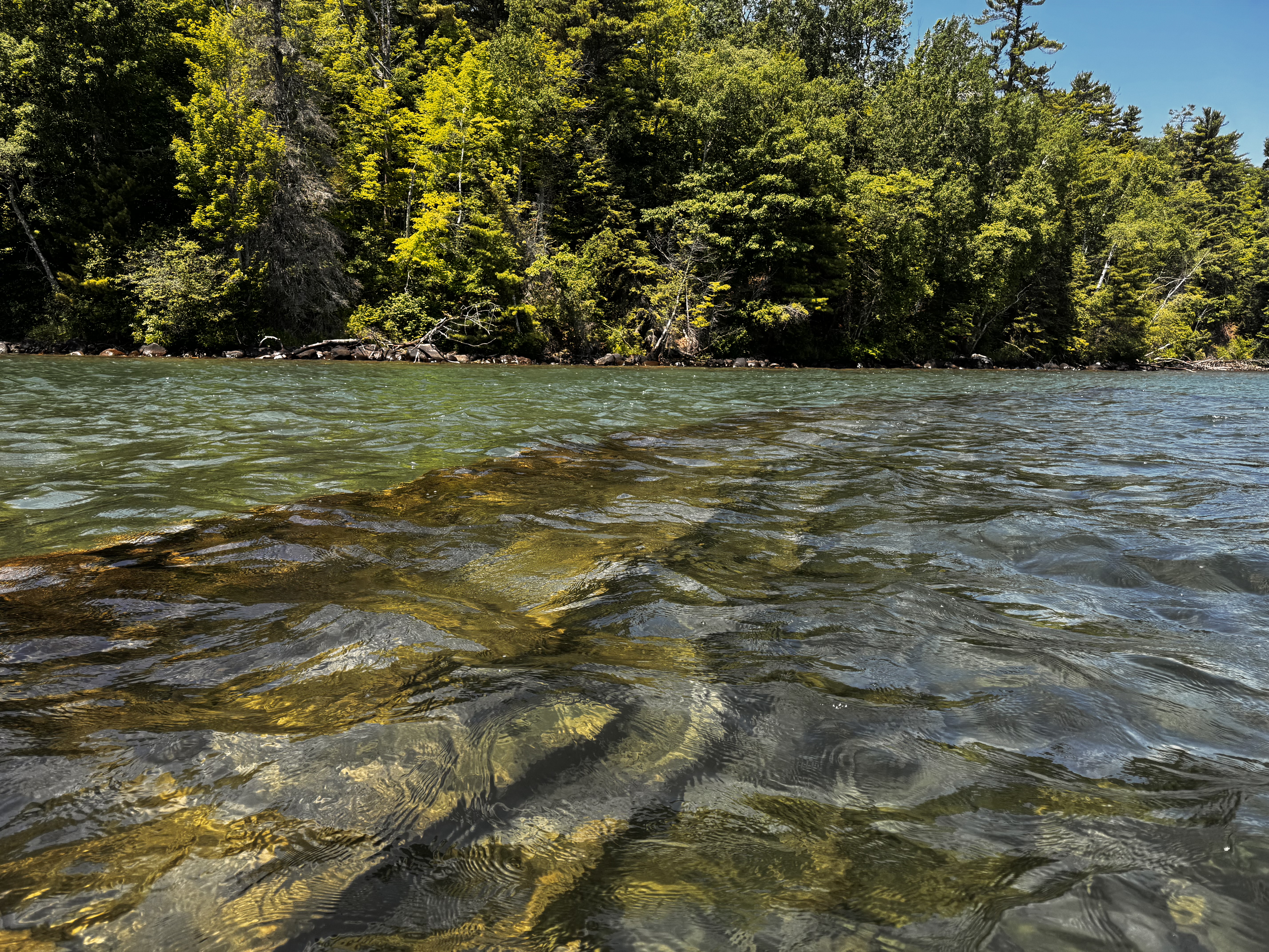
Along the way, we paddle over the mostly sunken remains of the Fedora. This 282' wood hull freighter sunk in shallow water in 1901 due to a fire. The wooden hull and iron ribs are obvious in the clear waters of the lake. Some remnant of one part of the ship rises slightly above the water, while the majority of the length remains safely under a few feet of water. As long as one is careful of the exposed portion, it is safe to paddle over the remains. I have to say that this is one of the more interesting things I've ever seen. I've seen shipwrecks before, but not on this scale. This boat is massive and clearly visible. 


Continuing towards Oak Island, the paddling is tough, but mostly uneventful. A lot of motorized craft and sailboats are on the water on this beautiful day. To get to the island, we have to cross a two-ish mile section of open water and stay pretty tightly grouped for this, but other than that there are no real challenges. 


We pull the boats ashore on Oak Island near our campsite in the early afternoon. Our guides quickly put together a selection of salami, cheeses, olives, and rehydrated hummus to give us some energy before we begin setting our tents up. The food hits the spot, as does getting out of the wet and smelly wet suit. We individually put our tents up and then I mention to one of the guides that I might explore one of the trails leading from camp. He asks how long I will be gone and I suggest less than an hour.

The trail I end up taking is the Sandpit Trail and I follow it for about a mile into the woods. I expected to eventually come across the islands lone dock, but after 20+ minutes of hiking, I decided to turn around. While I didn't see the dock, I did find lots of blowdowns, a rabbit, and tick crawling on my pants leg. Apparently, ticks are a real problem on the islands. Additionally, there are lots of mosquitos, biting black flies, and the most dense population of black bears in the US. At least we're in good company.


Getting back to camp, we enjoy a nice dinner around the campfire before calling it a night. We paddled 8.9 miles today. It's a good start to the trip.

Day 2

Bagel with cream cheese and fresh fruit are on the menu for breakfast this morning. I was up earlier than everyone, but the others rose pretty soon afterwards and we enjoyed a nice breakfast. I actually ate my in my tent as we had a light rain shower come through before we broke camp. It didn't amount to much, but did make packing a bit more of a pain. The mosquito bites on my legs didn't help much either.

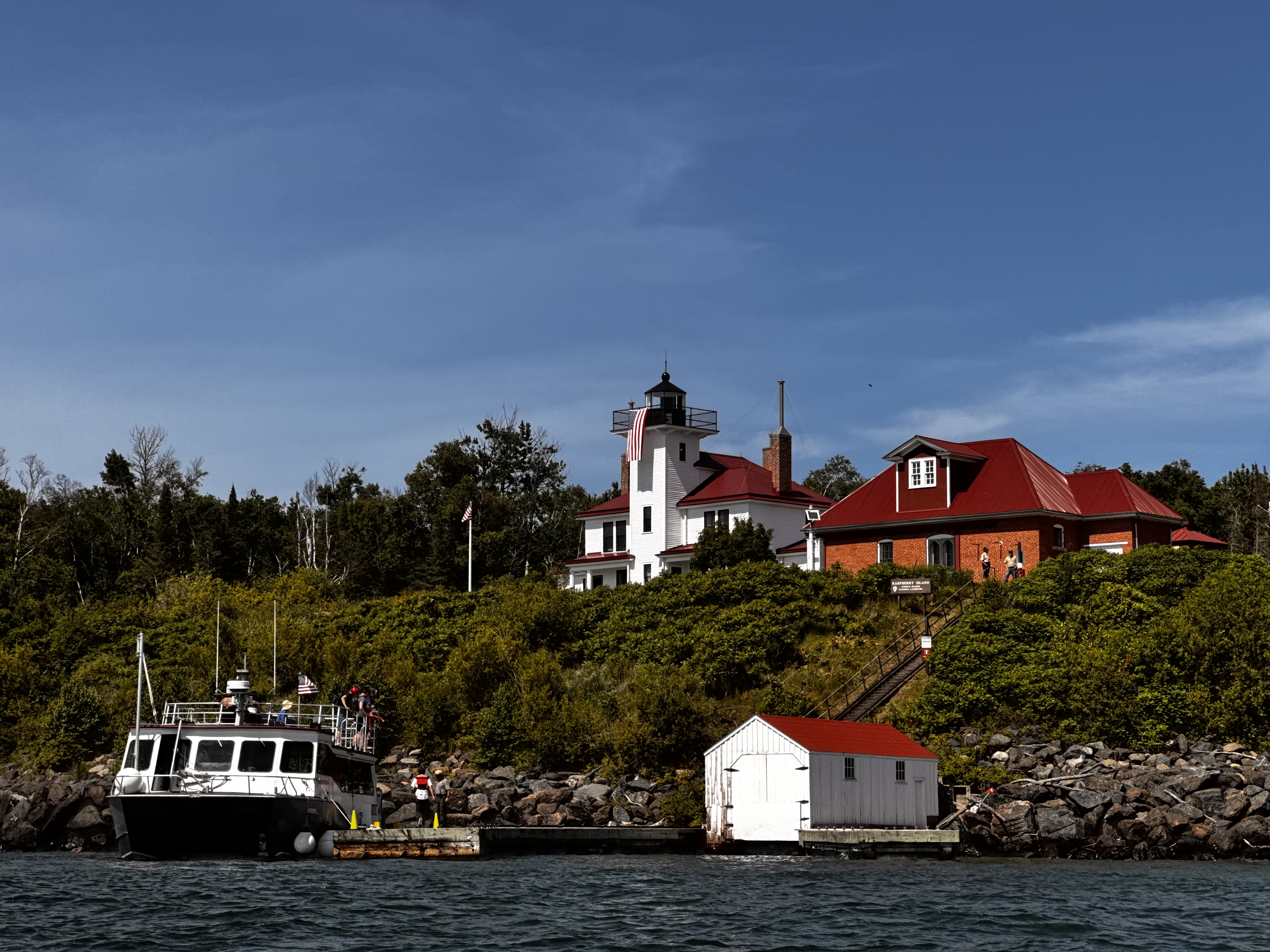
We hit the water around 10:00 am and paddled though choppy water and lots of rolling waves until we reached the southeastern corner of Raspberry Island. Here, we stopped for lunch with much of the same faire as yesterday. It was still a welcomed break though from the hard paddling. After lunch some of us hiked through the woods to the Raspberry Lighthouse, which is maintained by the Park Service. We were offered a tour of the facility, which we took and enjoyed. 


This lighthouse was built in 1862 to ward freighters off the rocky coast of the small Raspberry Island. Apparently, these areas were busy shipping lanes in decades past. Many of the islands in the archipelago have been fitted with lighthouses. It was interesting to learn about the facility and the families that lived here from the rangers. After our tour, we headed back to our boats, having hiked a total of 1.5 miles.

With that complete, we repacked our boats and got back on the water headed for York Island, which would be our home for the next two nights. Again, the paddle between the islands was pretty challenging with rolling waves reaching 8-10 feet tall and toss the boats all around.


Arriving on the backside of York Island, the waves were truly pounding the shore and the boat I was in nearly rolled as it got turned sideways along the shoreline and wave after wave pounded against its side. We eventually got everyone on land though without any injuries. 

Our campsite here is a bit more primitive and is nestled along the long narrow neck of the island. While there were a few spots at the edge of the woods to erect tents, I chose to put mine on the beach thinking the wind might keep the mosquitos under control a bit more. I'm not sure that worked, but it was worth a try.


As we got our campsite set up and dinner preparation was made, a large freighter could be seen in the distance. It's easy to forget, while on any of the islands, just how large Lake Superior truly is. It's really more of an inland sea, with the largest surface area of any fresh water lake in the world (and the third largest by volume). In fact, this lake contains approximately 10% of the worlds entire supply of fresh water. For all of its great size though, I've been sort of amazed at how little life there appears to be in it. There is little to no plant life to be seen below the surface and while I know there are fish in the lake, even as clear as the water is here, I never saw a single one. I think a big part of that is the northern latitude of the lake and related cold weather, which is dominate for more than half of the year.


For dinner, we enjoyed some chicken burrito bowls and then smores by the campfire. We paddled 9.2 miles through rough seas today and everyone is pretty tired. I think we were all in our tents by 10:00 pm or so. It's also worth noting that there is only about six hours of darkness here this time of year, so close to the summer solstice. It doesn't get truly dark until after 10:00 pm and the light returns shortly around 4:30 am.

Day 3

Around 7:30 am, a rainstorm rolled in. This one was more severe than the one yesterday morning and we experienced heavy rain for a couple of hours. Luckily, we weren't planning to paddle today and everyone congregated under a hung tarp while our guides prepared some loaded hash browns for breakfast - pretty tasty.

After getting my fill, I returned to my tent and listened to an audio book to wait out the rain. In the distance, we could hear fog horns notifying ships of each other's presence on the water. My roomy tent was comfortable enough and I shifted between laying on my sleeping pad and sitting in my camp chair (which I'm very glad to have brought with me). 


At about 12:30 pm, I crawled out of the tent and headed over to the camp kitchen to enjoy some spicy couscous and check in with my fellow adventurers. Everyone seemed to be doing well, but due to the high chance for further storms, our guides made the call to not get on the water today and suggested checking out the island on foot. As I was standing there enjoying my lunch, the damnable black flies continually bit my legs, which was actually pretty painful. After I finished eating, I chose to return to tent.

While the tent became like a sauna after the sun was directly overhead, it was a trade off between being hot in tent or being fly and mosquito food outside the tent. While most of my companions chose to walk the beach, I decided to remain in the tent and continue my book. It wasn't an ideal way to spend the day, but given the weather, danger of being on the water in a thunderstorm, and predatory insects, I think I made the right decision for me. 

I crawled back out of the tent for dinner, which consisted of a pesto-orzo pasta and a strawberry rice pudding for desert. I sat at the campfire for a little bit, but knowing that our plan was to get up early in order to a slight detour and visit some sea caves along Sand Island, I wanted to get to sleep at a reasonable hour. I was asleep before the sun was fully down.

Day 4

I awoke about 4:30 am to the sound of large waves crashing into the shore. My tent was only about fifty feet from the shoreline and they seemed massive. While not leaving my tent, I began getting dressed and packing for today's adventure. Once I crawled out, I saw that the waves were a bit more manageable than their soundtrack would lead one to believe. I managed to capture the spectacular sunrise, which always brings a since of hope and renewal for a great day to come.


We had a quick breakfast of oatmeal and then quickly broke down our campsite and loaded the boats. Everyone had planned the night before, which made getting ready and on the water much more efficient today. We were on the water by 7:00 am. Getting into my boat was pretty tough though with the waves crash against me. We all made it though.


York Island itself is one of the smaller islands, but paddling around the western end provided some nice views of the rocky sandstone shore with the waves crashing up against it. From here, we paddled almost due west across open water towards Sand Island. This is really what I came to see. The eastern shore of Sand Island is dotted with sea caves that have been carved out of the sandstone by eons of choppy waters and terrible storms. We first paddled alongside the caves of Justice Harbor. 

As we approached, the loud boom of the water hitting the back of the shallow caves could be heard for some distance. The water is far from calm today and the rolling waves make it somewhat difficult to get pictures, but I managed to get a few. This is the highlight of the trip for me. In calmer waters, it would be possible to paddle into the caves, but given that we are paddling over 8-10 foot waves, I suspect the fiberglass shells of our kayaks would be shattered against the rocks of the shoreline if we were to try to get any closer. 

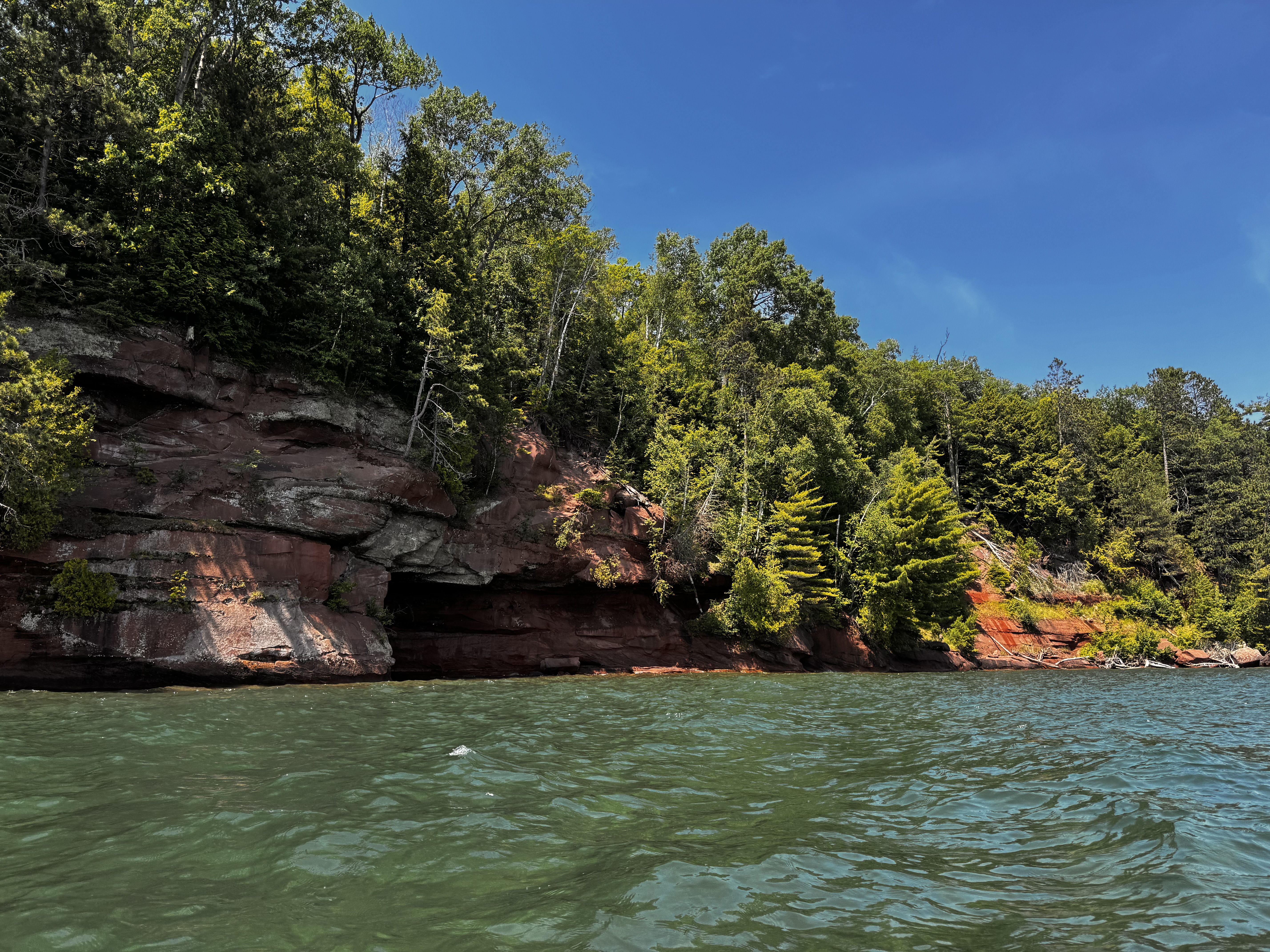
Heading south, we find more sea caves along the shoreline of East Bay. These are not quite a expansive as the ones to the north, but still very impressive. It's also interesting to see the trees clinging to the tops of the cliffs for dear life. Some surviving, while others fall into the lake to their eventual death - almost as if they are walking the plank.

The sea caves really were extraordinary and kind of made the whole trip worthwhile, but now it's time to return to the mainland and real life once again. Though with the winds picking up that may be easier said than done. 

As we turn our vessels southeast towards Sand Bay, the true adventure begins. We are now paddling into a 10-15 mph headwind, which doesn't seem like much and wouldn't be for a motorized boat, but when your only power source is the strength in your arms, that might as well be a hurricane. Huge waves (some 15 feet tall) crash against our small fleet of boats as we fight our way to our take out.

It feels like 95% of our effort is keeping us in place and only the remaining 5% is adding to our forward progress. If at any point, the nose of the boat gets unaligned with the headwind, we are quickly turned almost sideways and pushed backwards. My partner and I are paddling for all we are worth and still barely making any gains. The other boats, including our guides aren't managing much better. 

This final stretch of about 3.5 miles takes us nearly three hours to paddle. Eventually, we get into a position out of main headwind and that allows us to finish out the trip in a much easier fashion. That section though was without a doubt the most challenging paddling I have ever done. Wow - I'm exhausted.

Once we're finally on land, we take a minute to rest. I can barely stand. My legs and arms are numb from the incredible workout I've just undergone trying to return to the mainland. After I get some feeling back, I help the others and our base camp crew unload the gear and load the boats onto the trailer. Someone mentions that the Coast Guard had just issued a small craft advisory due to the winds and choppy water. Good timing, lol. This last leg of the journey was about 7.6 miles, but the most difficult without question. 

Back at base camp, we strip out of our wet suits and I take advantage the camp's hot showers to get some of the funk off of me. I'm sure my companions will appreciate that once we're stuck in the van for the ride back to Duluth. After lunch, we hop in the van and head back to our starting points. For me, that's the hotel in Duluth. Our total paddle trip was about 25.7 miles of rolling waves and challenging winds on this mighty lake, but it was well worth it. 

Sunday, June 29, 2025

Wilderness Camp (Bartow County, Georgia)

 Not content with only five miles for the day, I joined my normal Meetup group for another hike on the other side of the metro area around noon. The tangible humidity from this morning's sunrise hike left me a sweaty, stinky mess and so, I returned home to shower and take care of some chores before hitting the trails again. When I did finally start the drive, I encountered no less than three delays due to traffic accidents - a common occurrence and source of constant frustration in Atlanta. I called the organizer and told him I would be late and would just catch up on the trail.

When I arrived, the group was just passing back by the parking area and so it worked out well. I quickly joined in and we began making our way through the woods on this very new trail system called Wilderness Camp. It was opened earlier this year and was primarily designed for mountain bikers, but hiking is allowed. The trails wind around a wooded area just north of Lake Allatoona. In addition to getting in more mileage, I wanted to hike here since it was new. The trails seem very well maintained, being newly cut. That said though, this is another of those trail systems that just seems to wind back and forth on itself with no destination - a trail cut for the sake of having a trail. These are not my favorite, but it was still nice to get in some more trail miles and visit with friends while we made our way.

The humidity was as oppressive as a third-world dictator and towards the end, I felt some symptoms of mild heat exhaustion coming on. It's probably good that we finished when we did. The group got in a half-mile more than me due to my late arrival, but I still managed to add another 6.2 miles to my total for the day. Now to head home and relax . . . and get another much-needed shower.

Indian Seats Sunrise (Forsyth County, Georgia)


I decided to rise super early this morning to join the Atlanta Outdoor Club for a hike to see the sunrise from Indians Seats on Sawnee Mountain. The trailhead is only about fifteen miles from my house and so it seemed pretty doable. I got up about 4:30 am and after getting ready, drove to the trailhead. I arrived to meet the other hikers in the dark around 5:45. After a very quick round of introductions, we hit the trail in the increasing ambient light. 

The organizer was keeping a strong pace of nearly 3 mph, which was outstanding. There is a bit of uphill, but nothing crazy and it was light enough that I didn't need my headlamp, even though I had it with me. After just a few minutes at this pace, we reached the Indian Seats rock outcropping and observation deck atop the northern peak of Sawnee Mountain. The face of the mountain was not ideal for catching the rising sun in the east, but we could still get a glimpse around the trees. I always find it refreshing to see the sun rise and even though, the humidity is already thick this morning, the early call time and short hike were definitely worth it.

After climbing around on the rocks a bit and getting our last pictures of nearby star, we headed south to complete another loop around the southern peak just to get a few more miles in. We maintained the strong pace and when finally arriving back at the parking lot had completed about 5.4 miles. And it's only about 8:15 - glorious way to start the day.

Saturday, June 21, 2025

Sweetwater Creek Evening Hike (Douglas County, Georgia)


It's been a busy day. Having run a 5k this morning and then attending a beer festival in the afternoon, I could easily just relax this evening, but instead I had made plans to join the Atlanta Outdoor Club for an evening hike through one of my favorite Georgia State Parks, Sweetwater Creek. The club organized this with the park service and we will be lead on the trails by one of the park's long-time rangers.

We met near the visitors center and were asked to move our cars to the staff parking lot, as the park closes to visitors at dusk and we've been allowed to stay a bit later than that as a part of this organized hike. We started the hike by heading towards the ruins of the New Manchester Mill, which sit along the rapids of the large creek. The mill was torched by Union Troops only a few years after it's construction, as Sherman marched towards Atlanta. It was a massive factory though as can be seen by what remains. We were also allowed a rare treat, which is to go beyond the locked fences into the remains of the structure itself.

After leaving the ruins, we headed north along the creek, while our ranger guide stopped occasionally to share information about various things of interest like plants or historical notes. Soon, we reached the sturdy bridge and crossed over the wide creek. This new bridge was only completed a couple of years ago and in the creek below, the ranger pointed out the remains of an older bridge, which was actually a portable army bridge that was brought here for use after the Vietnam War. That one was wiped out in the flood of 2009.

Now on the eastern side of the creek, we make a long path south over hills and into hollows. As evening creeps in, we see several creatures of the forest, including a few deer, a box tortoise, and a couple of toads. It's always great to see the life that resides here in the woods. 

With darkness approaching, we start to head back towards the visitors center. All along the way, we enjoy some nice conversation. We arrive back at our cars long after the sun has set. It's nearly 10:00 pm, but it was well worth the effort. The only downside was the thick humidity. We're all drenched, but that's life in Atlanta. In total, we hiked about 6.4 miles of the park's terrific trail system. It was a fun experience and I thank the club and the ranger for allowing us this experience.

Wednesday, June 11, 2025

Fort Yargo - Dusk Hike (Barrow County, Georgia)

In an attempt to get a few more miles in this week, I signed up for a ranger-led "full moon night hike" at the nearby Fort Yargo State Park. The hike was scheduled to start at 8:00 pm, but before leaving my house, I checked and noticed that moon rise wasn't going to be until 9:39 pm, meaning we wouldn't really get to see much of the moon. To further complicate things, spotted rain showers powered down on me the entire drive to the park. 

When I arrived, I found a couple of ranges and a couple of other participants standing around the visitors center and taking shelter from the rain, which had been reduced to a very light sprinkle by now. After chatting a few minutes, the ranger made the decision to cancel the hike due to muddy conditions on the trails. I wish he would have said something sooner, but he did say that the park and trails were open until 10:00 pm if we wanted to explore on our own. I came to get miles in and that's exactly what I intend to do.

Leaving the visitors center, I headed south over the long bridge/boardwalk to the other side of the lake. There was still plenty of light at this point, but I had my headlamp ready to go just in case. I was keeping a pretty good pace, but he humidity after the rain was brutal. Following the trail system, I arrived at the newly opened beach area and decided to turn back. Lightning bugs were beginning to come out, which made for a magical return trip. 

Nearing the long bridge again, I spotted a large heron standing on the shoreline of the lake. I gently moved to get a picture and was able to capture his silhouette with the lake in the background. I thought it was a nice picture. With darkness setting in, I decided to call it a night and finished the hike back at my car with about 2.4 miles completed. Not much, but better than nothing. 

Sunday, June 8, 2025

CRNRA Bowmans Island (Forsyth County, Georgia)

 Once again, the area I live is dodging storms, but it seems they are moving south of me today. I'll take advantage and get some trail miles with the Meetup Group. After arriving at the Bowmans Island parking area, I was greeted by several friends before we did our customary round of introductions and hit the trail. Our plan was to hike across the dam, up the stairs and explore several of the peninsulas jutting out into Lake Lanier, but for whatever reason, the park service has the gate to cross over the dam closed and locked. 

We quickly shifted our plans and began heading south into the Bowmans Island Unit of the CRNRA (Chattahoochee River National Recreation Area). I've hiked all of this before and for my purposes today, one trail is as good as the other. The trail follows the river for a bit before ducking inland just a bit and then returning to the river and continuing south. Eventually, we reached the Buford Trout Hatchery. This facility is open to the public, but since my last visit they have constructed roofs over the hatchery tanks and applied a chicken-wire fence around them. It still allows folks to see the trout of various ages swimming in the tanks, but presumably protects them from predators (and perhaps degenerate visitors). 

Returning to the trail, we began making our way back towards the calls. As always, we enjoyed some great conversations along the way. It was a great way to distract from the overbearing humidity. It's hot today and I'm sweating like a pig. Getting back to the parking area, I see we got in about 7.1 miles. It was great to see friends, but now I need to get my stinky, sweaty butt to my shower.

Saturday, June 7, 2025

Roswell Riverwalk (Fulton County, Georgia)

With more storms coming in this afternoon, I didn't want to venture too far from home, but I still wanted to get some exercise and trail miles in today. I decided to re-visit the Roswell Riverwalk, which is only about a thirty minute drive from my house. It's going to be a hot day, but this paved trail along the Chattahoochee River will offer some shade and it will give me a chance to continue listening to an audio book series I've been on. I wouldn't normally hike with headphones, but this is a paved urban trail with a few sections of boardwalk. So, I'm not really concerned with wildlife elements.

Parking my car at Don White Memorial Park, I used the nearby restroom, started my audio book, and headed west along the paved trail. I guess a lot of other people had similar ideas today as the parking lots are filling up and many walkers, runners, and bikers are using these urban trails today. It's still early and I turned my ball cap around to allow the bill to protect the back of my neck a bit as I start my walk. 

Reaching Riverside Park just a half-mile or so down the path, I stop to read a number of placards describing some of the atrocities visited upon the Cherokee when they were forcibly removed from their land and sent along the Trail of Tears to the Oklahoma territory. Further, I read another sign that describes the lynching of a black man in the 1930's for the offense of kissing a white woman's hand. Sadly, no one was ever charged with his murder. I know I'm not responsible for the acts of my ancestors and I can only try to ensure that I spread a different message of hope and equality. I try my best.

The trail continues onto a couple of sections of boardwalk through some swampy areas and I take some time to admire some wildlife, including a banded water snake swimming along at the Confluence of Vickery Creek and the river. Further along, I also see what I believe are catfish flopping about in the shallow muddy waters. It's great to see these creatures.

Finally reaching the very long boardwalk section that ends at Willeo Park, I turn around and head back. As I pass back through the muddy backwaters area where I had seen the catfish before, I spot a snapping turtle about he size of a hubcap raise his head from the mud for a breath of air before returning to his camouflaged resting place. 

The final couple of miles on the way back to the car were uneventful, but as the clouds start rolling in, I realize that it is time to head for home. When I finally get back to my car, I notice that my GPS tracker was showing over 9.5 miles on this trek, which I know is off. When I review the path, it seems something weird happened around mile 6 on my way back and it had me bouncing all over the place. I know from past experience that his walkway is about 7.6 miles and so, I'm going with that and using a track from a previous visit. While there is nothing special about this little riverwalk, it is a pleasant way to get some fresh air and exercise. I'm glad I was able to enjoy it today before the coming rains.