Another quick hike recommended to me by Emily, my tour guide for Fern Cave, was Hidden Valley, which just happens to be directly across the gravel road from Big Nasty Trail, and as such, I felt obligated to check it out. Even though, I was already hot and sweaty from the hot sun and exposure of the previous trail, this one seemed to have a lot of shade.
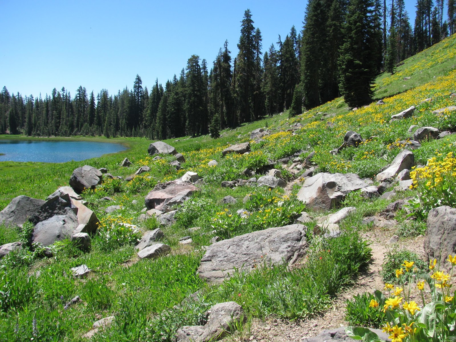
The trail starts ominously as it leads back into the trees, but quickly reveals the subject of the name. A large depression, perhaps a large collapsed lava tube, opens up and reveals an elongated valley, densely populated with pine and other greenery. While there probably are ways to climb down into the valley, I don't look too terribly hard and simply follow the prescribed trail alongside the small valley.
It only leads about a quarter of a mile before sputtering out among the forest and lava remnants, but offers some very nice views of the little valley below. With that though, I must be on my way, the sun is beginning to set in the west and I have miles to go before I rest.
With several hours of daylight remaining after my tour of Fern Cave, I wanted to knock out a few miles and enjoy some more of the park, before returning home. I had asked Emily, our tour guide for the cave, about reasonable hiking options given the time of day and heat. She suggested a couple, including Big Nasty Trail. How could I not check that one out?
The trail head is diagonally across the park from Fern Cave, but not difficult to find. It starts at the top of Mammoth Crater, a medium-sized volcanic crater in the extreme southern end of the park. After leaving the make-shift parking lot, I make my way up a very short hill to the edge of the crater and then proceed down a paved walkway to an observation deck just below. The view from here is quite impressive, but not unlike other volcanic craters I have visited in the past.

Making my back up to the edge, I find the sign for the 'Big Nasty Trail', which I will discover is not really 'big', nor really 'nasty'. The first part of the trail follows the southern rim of the crater with views of many of the nearby cinder cone volcanoes and assorted lava fields surrounding the entire area. Eventually, the trail forks and begins the loop, which I had seen on the map. Not knowing if one direction was better than the other, I take the left fork and make my way out into the lava crusted desert. It's hot. It's very hot, but I have water (though, it hasn't been cold in a long while).

The trail twists and turns as it climbs over volcanic glass streams that presumably poured out of the crater long ago and dried in their current resting places. It is pretty desolate out here, but the occasional tree offers some shade. As I push on, I wonder if there is actually a destination for this trail. In fact, there isn't. The trail simply meanders out into the desert and then loops back to the fork I mentioned earlier.
While there is certainly a lot of beauty to behold along this trail and the views of the crater or very nice, the lack of a destination and the extreme hit combined with the exposure, prevent me from thinking overly wonderful thoughts of this trail. Still, it was an overall pleasant walk of about 2.5 miles, but now I need some shade.
***PLEASE NOTE: All photos of Fern Cave displayed here are borrowed from Google Images and were not taken by me, as photos are no longer allowed inside the cave at the request of the Modoc People
Looking at my calendar a few weeks ago, I realized that I had a free weekend at the end of July and began brainstorming for some day trips. I had been to Lava Beds National Monument a couple of years ago, but it was really more of a pass through than a real exploration of the park. Looking at the NPS site, I saw there were a couple of caves (lava tubes) that could only be accessed via ranger-guided tours, and from the schedule, it looked as though these tours were challenging to reserve, but as luck would have it, there was a single spot available for the day I had in mind. So, I booked it.
The drive from Reno to Lava Beds is about four hours long and traverses a combination of high desert and sub-alpine forest, along with the obvious volcanic activity in the area. As my tour wasn't until 2 PM, I didn't get a super early start, but I did arrive in plenty of time to get checked in, go through the mandatory white-nosed bat syndrome screening, and make it back to the meeting area at Hospital Rock with time to spare.
Emily, our ranger guide, arrived just a couple of minutes after I did and we began talking about the tour and the park in general. The other participants all arrived shortly thereafter and we loaded into the Park Service's mini-van to escape the high-90 degree temperatures and to be shuttled to the entrance to the cave, which is a short distance down a gated and locked gravel road just off of the main road and west of Hospital Rock. After exiting the van and hiking a tenth of a mile or so through the open desert and lava fields, we arrived at the 'sky light' to the cave, which is essentially a section of the lava tube's ceiling that had collapsed in the distant past, revealing the cave below.
As this cave is sacred to the Modoc people, it has a locked grate completely covering the skylight and preventing any trespassers from entering. The Park Service has special, all-be-it limited permission to enter the cave with visitors, while tribal members have full access at any time. Emily performs a short ritual of burning sage to honor the Modoc tradition and tells us a bit about the known history of the cave. Even from up here and before the grate has been opened, it's obvious there is something special about the cave, as a collage of lush green ferns reaches for the sun from the cave floor below, thus giving the cave its name. The ferns are a stark contrast to the vegetation on the surface, which is covered with the dull green and brown sea of sage brush and other desert flora. Its no wonder the ancient Modoc saw this place as an oasis.
Unlocking and opening the grate, I help Emily lower the ladder down into the cave through a mechanism designed into the grate, presumably to keep the ladder secure. She goes down first, I follow, and then the remaining members of our tour make their way down into the cool dampness of this holy place. Emily marks the boundaries of where we are allowed to explore with her flashlight and we make away around the cave.
Just below the skylight, a green tower of ferns rises, presumably on top of the rubble that collapsed from above long ago. The more central to the sunlight peaking through, the larger the ferns grow. From leaves more than a foot long at the center to the tiniest fern leaves you can imagine, easily mistaken for a blade of grass, carpeting the area around the center in a micro-green field - truly magnificent to behold.
Searching the walls of the cave, I'm amazed by the number and density of the pictographs here in shades of black and white and everything in between. Figures possibly representing families, maps, spirals, and all sorts of other designs. Presumably, the Modoc visited this cave as part of a spiritual journey and perhaps preserved their visions on the walls for future generations to see. I very much would have liked to record some of these images with my camera, but I respect the Modoc's wishes and save them only to my memory.

We spend 30ish minutes exploring the cave, as Emily explains that the Modoc may actually go further back into the cool lava tube than we are allowed to, but that their heritage and their right as the ancient owners and discoverers of this wondrous place. After exploring a bit and pondering on the spirituality of this ancient and holy place, we make our way back up the ladder, re-secure the grate, and drive back to Hospital Rock. Emily had warned us that visiting Fern Cave could be a religious experience and she wasn't far off. It is truly an amazing place and I would highly recommend visiting it given the opportunity.
I have never really down much hiking in the Olympic (Squaw) Valley area, but when a posting came up for one in that area on one of the local meetup groups I subscribe to, I had to jump on it. Meeting up with the large group just outside of Reno, we caravaned to the trail head at the popular Squaw Valley Ski Resort. The trail started with with fairly rugged creek crossing, but quickly leveled out to a slow incline as we followed Squaw Creek up Shirley Canyon. Along the way, we passed a couple of small, but pretty waterfalls.

Soon after passing the waterfalls, the trail began to cross some large, steep granite inclines. The path was pretty well marked with blue arrows having been spray-painted on the stone, but it did nothing to make it less steep. It was a pretty enjoyable workout. After the lead group reached the top, we were greeted by Shirley Lake. As the remaining members of our large group caught up, we found suitable spots to rest in and amongst the granite boulders to have a quick lunch before moving on. A couple of our gang even took a quick dip in the calm waters of the lake.


The climb out of this area was a bit steep, but not as much so as the climb to it. Reaching the top, we followed some service roads to a monument built to honor the Emigrant Pass, which was built here in the mid-1800's. After collecting all of our members once again, I and a couple other of the more adventurous hikers decided to scout out a way around a fairly rugged notch of the ridge, but eventually find a way down. The rest of the group follows along and we begin to make our way up to Squaw Peak. Again, I and a few others chose to take a path that was slightly steeper, but much shorter, to get to the top. The views from the top are incredible, with Lake Tahoe in the distance, as well as a myriad of peaks well known to our group of hikers.

After making our way down the mountain, we hiked around the valley to the bar and pool area, which was home to a large number of people enjoying a leisurely day. Having to wait a short time while the restaurant staff prepared a table for a party of twenty, we sat on the deck and had a few beers. We were quickly seated and placed our orders, all the while enjoying good company and good conversation. The food and beer were terrific and we lounged for a bit, before taking the tram down the mountain back to the parking lot. The tram itself is actually pretty cool, as it is the only funitel style transport in the US, but even more so because of the steep grade traverses as it carry more than 70 people down a set of steel cables to the parking lot below.
We said our goodbyes and headed back to Reno after another great trip with Deanna, the organizer. In total, we hiked about 8.4 miles, but unfortunately, I had reset my GPS tracker early in the trip and so can't create the topographical map I generally post. A great way to spend a Sunday afternoon.
For the final hike of my weekend camping trip to Lassen, I wanted to check out two sites - Cold Boiling Lake and Mill Creek Falls, both of which are along the same trail. Arriving at the Kings Creek Picnic Area, we decide to take an early lunch break before hitting the trail. Knowing that we will be putting in 6+ miles, it seemed like a good plan. As luck would have it, I had one beer left from last night and it went down very smoothly.
Shortly after finishing a quick lunch, we hit the trail, which rises pretty sharply out of the parking lot. Only about a half of a mile in, we take a quick turn to Cold Boiling Lake, which is just off of the main trail. Not knowing exactly what to expect, I find a sign on the shoreline explains that the bubbles in rising from the lake waters come from cold gas rising from under the surface. It's not dangerous as many of the other geothermal areas tend to be, but it's also a bit of a let down. I was honestly expecting a something a bit more exciting, but that's okay, we still have another stop on this trail.

Pushing further on, we encounter a number of snow piles in the forest, protected from the sun's rays by the shadow of the tall pines all around us. It's mostly melted though and poses no real obstruction to the trail. As the trail opens up into a large meadow, my friend Bill and I are in awe of a terrific scene. Crumbaugh Lake to our left, and a wild-flower carpeted, steep hillside to our right. It's a really pretty picture, but it's not our destination and so, we move on.
The trail is well cut, but the melting snow makes for a few muddy patches here and there - nothing substantial though. After passing through more forest and past another wide meadow, we begin our descent into the canyon that ends at the confluence of Bumpass Creek and Mills Creek. The trail is very steep and while it is well maintained, we both still slip a couple of times. We both comment on how much 'fun' the climb out of this canyon is going to be on the way back.
Encountering a young couple resting on the side of the trail, I ask how much further to the falls. The respond by telling us it is just ahead. And after a few more switchback, they are proven correct. A couple of sturdy wooden bridges offer safe passage over the meeting creeks, and a few steps climbing down the rocks on the far side of the bridge leads to a spot directly across from the falls.
While I can't get an great angle to see the entire falls, the fast-flowing water plunges over a worn rock into the valley far below, which opens up into a great view of the park. We take a 5-minute break to get some water and a snack, before heading back the way we came.
The climb out proves to be as challenging as we thought it would be and wanting to get a good workout today, I actually run up a short distance of the hike. We eventually ascend to the top and make our way back to the trail head. While Cold Boiling Lake was a bit disappointing, the waterfall proved to be well worth the trip. Total distance was just at 6.5 miles round trip. I fire up the jeep, start a shuffle of a heavy metal play list, and we are Reno-bound.
After good night's sleep in the cool alpine air of 7500' feet, Bill and I broke down our tents and started packing the jeep. As this was intended to be a relaxing weekend, we weren't in any big rush, but eventually headed out for our first trail of the day - King's Creek Falls. It's just a short drive from the campsite, but once we reach the trail head, I park the jeep in the pull-off and we make our way down a set of stone steps to the start of the trail.
Intending to do a full 5-ish mile loop, we pushed our pace pretty hard as the trail moves along and above a small stream. That stream would become the source of the falls, but before we learn that, we have to deal with some trail closures/detours. Apparently, the hiking conditions are dangerous on the trail to the falls due to snow and loose rocks. The Park Service has closed it temporarily and suggested an alternative that takes us to an overlook, high above the cascading falls.
Once we arrive at the end of the detour, we are greeted with a nice view of King Creek flowing through a stone canyon and cascading over a several small falls. Other hikers have found perches on the various rocks and are taking in some of nature's beauty. We spend a few minutes more, before heading back to the jeep.
With the detour and closure, this was just short hike of 1.5 miles or so, but it was a good way to start the morning. On to the next one!
A weekend camping trip to Lassen with a few day hikes, good campfire-cooked food, and cold craft beer - what's not to like? After picking up my buddy, Bill, at about 10 AM on Saturday morning, we headed up towards Susanville. For a while now, I've been wanting to try some of Lassen Ale Works concoctions and so, we stopped in for lunch and a flight of their finest. The beers were pretty good, but only the Volcanic Double IPA really stood out as exceptional. We arrived at the park by about 1:30 and headed for our campsite at Summit Lake South. After putting up our tents and putting our food into the bear locker, we headed out for the first hike of the weekend.

I've been to Lassen several times over the years, but I wanted to hit some of the less popular trails on this trip and as it was Bills' first trip to the park, he was open to anything. For the first trail, we decided to head to Cliff Lake. The trail head is actually on the side of the road a bit north of our campground, but wanting to get a few extra miles in, we simply hiked around Summit Lake from our campsite to get there.
The trail was pretty mild, with only a slight incline. It runs alongside a small stream carving its way through the forest. As we follow the flow upstream, the forest opens up into lush green meadow, with the stream cutting through the center of it and with a snow-covered peak as a back drop. It's a post-card!
A bit further on, we hit a fork in the road and follow the trail to Cliff Lake, which is just a short distance off of the main trail. Arriving at the lake, we are presented with a pristine alpine lake - crystal clear water, surrounded by pine trees, and with a snow-covered rocky cliff in the back drop. Obviously, the granite cliff overlooking the small lake is the source of the name.
We hike around the shoreline a ways to find a stream at the base of the cliff feeding the calm waters of this beauty. Afterwards, we turn back and head for camp. We hiked just short of seven miles round trip, including the trip around Summit Lake. We arrived back at camp at the perfect time. Fire going, food cooking, beer pouring - ah, a great evening!
A trip with Deanna's Advanced Hiking Meetup group is always a great time and today was no exception. I had signed up for the trip a few weeks back, but after rolling my ankle pretty badly a few days ago, I was a bit reluctant. I ran on it a couple of miles yesterday and it seemed to do okay, and so, I decided to go ahead with the hike. Meeting the large group at the Red Rock exit a few miles north of Reno, we caravan-ed up to Graeagle. With the top down on my jeep, it was a bit cool, but manageable.
We arrived at the Jamison Mine Trailhead at about 9:30 am, and the group, now twenty strong, headed out for a day of hiking in the Lakes Basin area. I have hiked in the general area before and heard about the large number of beautiful alpine lakes in the area, but this was my first experience with the immediate area.
The trail climbs steadily out of the gravel parking lot and heads into the heavily wooded forest. Everyone in this group always keeps a good pace, which I appreciate. After about a mile, we stop to see a small waterfall just off of the trail. Though it is July, the water was still flowing pretty ferociously over this fall. We quickly hit the trail again and continue the gradual incline, finally arriving at the first of our many lakes to visit, Grass Lake. This one is fairly large, but a bit mossy. The dogs that are with us don't seem to mind though as they dive in for a swim.

Moving on pretty quickly, we head on towards the next lake, Wades Lake, which sits in a small granite bowl. As we approach the water, we encounter a couple of campers. We ask about their stay and they tell us they have been here three days. I can certainly see why. The lake is amazingly beautiful and the campsites available on this, the north side, of the lake are outstanding. I might have to return here someday and take advantage of it myself. We pause for a few minutes to wait for the entire group to catch up and have a snack, while we wait.

Soon enough though, we're back on the trail and making our to the third lake, Jamison Lake. Deanna had mentioned that she was planning on the group stopping at this one for lunch and to swim if anyone was so inclined. The lunch was a good idea as we all lounged on a large rock outcropping, but the cold breeze flowing over this lake discouraged most from jumping. Not everyone though, one brave soul from our group braved the cold water and frigid air. He said it wasn't too bad, but failed to convince anyone else to join him.

After a short respite, we were once again on the move. So far, my ankle seems to be doing pretty well. It's still a bit sore, but I feel like I need to start putting pressure on it again. We descend into the bowl of our last lake, Rock Lake. This one also has a few campers enjoying the shoreline. We play around on some of the large rock outcroppings and skip a few rocks off of the clear blue water. I suddenly need to find a tree to water and make my way around to the other side of the lake, only to stumble on another small lake just behind. This one is really picturesque in that it has a large granite boulder rising from the center and grasses growing out of the water in a serene crescent shape around the rock - really cool.

Finally, we regroup and start to make our way back to the parking lot. Though everyone here is a pretty strong hiker, we end up splintering into smaller groups, of which I'm in the front one. I end up finding a wonderful loose rock and feel a nasty twinge when I put weight on my sore ankle on top of the rock, but it is short lived. Arriving back at the parking lot, I check my GPS app and find that we've covered just over 8 miles. It was a good recovery hike for my ankle.
As with most hikes with this group though, arriving back at the trail head is not the end of the day. We stop for a few beers at the Brewing Lair in Blairsdon, which is on our way back to Reno. A total surprise to me though, folks have prepared a rather well-stocked picnic for us to enjoy out on the decks of the brewery. Good food, good games, good beer, and good people - it always makes for a fantastic day.