Friday, October 30, 2020

A Vampires Tale - Full Moon Night Backpacking on the AT Woody Gap to Blood Mountain (Union County, Georgia)

I've had a number of backpacking trips cancelled this year due to the ongoing COVID-19 pandemic. Additionally, I tripped, fell, and broke one of my fingers while on my morning run a few days ago. So, when one of the local groups I've been hiking with posted a moonlight overnight trip to Blood Mountain on Halloween Eve, I couldn't help myself from signing up. This particular group tries to strictly define and record their members past experience, which I can completely understand. It gives trip leaders some basis to determine who is capable of the tougher outings, of which this is one. Since I have only a few outings with the club, the trip leader contacted me in advance to ensure I knew what I was getting myself into. I explained that I was a recent transplant to the area and listed off some of my experience out west, which put his mind at ease.

We met, all eight of us, at the Woody Gap Trailhead, which is on the Appalachian Trail (AT) around 8:45 PM. At elevation and with a brisk wind blowing in, it was pretty cold up there, but the brilliant full moon above our heads inspired us and our thirst for adventure kept us warm while we assembled our gear. After a quick round of introductions, we hit the trail promptly at 9:00 PM as scheduled. It seems many of these folks have been on trips together in the past, but they welcomed me with open arms.

The first mile and a half or so up to Preachers Rock is somewhat steep, but bathed in full moonlight the trail was easy to follow. As we got to moving at a pretty good pace, our bodies heated up quickly and it was soon time to strip off some layers. Along the way, a couple of my fellow hikers inquired about the splint on my left hand protecting my broken finger. I think they thought I was a little crazy for doing such a crazy backpacking trip in such a condition, but they kept their thoughts to themselves. In truth, the splint only proved to be a minor inconvenience during the trip. I think the worst part was not be able to put a glove over that hand when we stopped for longer breaks such as to take in the view from Preachers Rock. The cold air had a numbing affect.

The next several miles undulated as we followed this section of the AT over some smaller mountains on our approach to Blood Mountain, which is the highest point along the Georgia section of the long trail. We did see a few tents along the way, but no other hikers. Only crazy people would be out hiking during the midnight hour of a full moon on Halloween . . . or vampires . . . 

Arriving at the Blood Mountain Shelter, we removed our packs put on additional layers and sat or layed out on the bare granite to take in the cloudless night sky, of which the full moon was the centerpiece. After laying on the cold stone for a couple of minutes, I decided to pull out my foam sleeping pad, which was easily accessible from my pack and lay on that instead - good call. The combination of comfort, cool air, and the fact that I had now been awake for nearly 24-hours straight began to weigh on me and I could feel myself starting to slip into slumber. Luckily, we didn't stay long and soon headed back down the mountain to our planned campsite, the Woods Hole Shelter.

Now feeling much like a zombie as the clock nears the 3:00 AM hour, we trudge a half-mile off trail only to find the shelter full of other campers. After a quick discussion, we make the group decision to return to the fork in the trail and camp there at a decent spot we saw earlier. The only real concern is food storage in this bear-populous area. I packed my bear can and so, I felt okay about. After we got our tents set up, I offered up the additional space in my can for others to use, which they thank me for and took advantage of. For just an overnight trip, I didn't pack a lot of food and was happy to share the ample storage remaining in my bear can.

While I told everyone good night and quickly traveled off to dreamland, some of my fellow hikers decided to get a fire going and have a few beers, which they had packed with them. I would have loved to joined them, but now after 4:00 AM, but body was having none of it. I crawled into my sleeping bag and was out like a light.


I was the first one out of my tent at about 9:00 AM, but others rose shortly afterwards. Apparently some of them were up until nearly 7:00 AM. Even so, they were quick to rise and get some breakfast going around the campfire. The sun is shining brightly this clear Saturday morning, and while there is a chill on the air, it's manageable. Some hot tea and a warm breakfast certainly help. As we finish our breakfast and chatter around the fire, some of the hikers that had stayed at the shelter drop off some snickers bars for us on their way out. It's a nice breakfast desert.

Soon afterwards, we break down our tents, load our packs, and start the trek back to our cars at Woody Gap. I don't remember this being quite so steep last night, but with the dark and my groggy state, maybe I just didn't notice. The group spreads out over a pretty good distance, but our group leaders are good about waiting for everyone to occasionally catch up. 

Finally arriving back at the trailhead, I thank my fellow adventurers for an excellent time. We hiked 11.3 miles last night and another 7.5 this morning, for an 18.8 mile total trip distance. They all wish me well and we look forward to meeting again on the next trek. As for me, I've got an hour-an-a-half drive between me, my shower and my bed.

Wednesday, October 7, 2020

Great Serpent Mound (Adams County, Ohio)

 
*Photo courtesy of Google

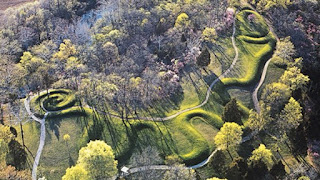
Roughly one hundred miles southwest of my last stop at the Alligator Effigy Mound rests my last stop on this vacation road trip. Here, the second and more notable effigy mound rises from the earth. The Great Serpent Mound is certainly much larger and discernible. Recognized as a National Historic Landmark, a modest park has been built around the Native American construct to protect it and make it more easily accessible to visitors.

After paying the parking fee, I immediately begin walking the short paved trail that encircles the undulating coils of the serpent-like effigy. A somewhat rickety observation tower has been constructed to provide a birds eye view of the mound. I carefully make my way up. The view from here, approximately sixty feet above the ground is outstanding. From up here, one can see the seven coils of the snake spreading out over several hundred feet and rising three or feet above the surrounding ground in most places. Unlike the Alligator Effigy Mound to the northeast, there is no doubt what I'm looking at here.


Debates about the builders of the mound are ongoing, but the two leading theories attribute it to either the Adena Culture or the Fort Ancient Culture, having been built around either 320 B.C.E. or 1070 C.E. respectively. Whomever built it obviously had a grand scheme in mind, as the detail and massive nature of the venture leaves no doubt of the craftsmanship. But why did they build it? Many questions linger about such ancient endeavors, and will likely never be answered. For now, we'll just have to appreciate the amazing legacy these ancient peoples left us.

Alligator Effigy Mound (Licking County, Ohio)

 
*Photo courtesy of Google

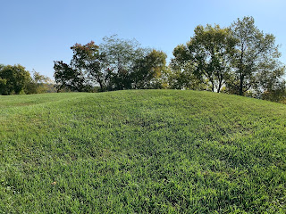
My next stop along this road trip takes me to the first of two Native American effigy mounds in Ohio. The Alligator Effigy Mound resides in a residential area. Atop a grassy hill surrounded by homes, the shape of a four-legged creature with a long tail can just barely be discerned. It was likely meant to represent something other than an alligator, but for whatever reason that is the name it has taken on. I walk around the effigy a bit and I'm not convinced I would even know it was here were I not looking for it. It is believed to be the work of the Hopewell People sometime between 100 and 400 C.E., but Archaeologists are not entirely sure of it's origins.

Tuesday, October 6, 2020

Rock House (Hocking County, Ohio)

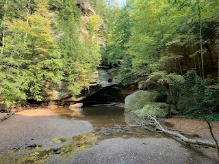
Rock House is the final place I plan to visit during my trip through the Hocking Hills of central Ohio. Unlike some of the other "caves" in the area, such as Ash Cave, this one is a true cave in the fullest sense, though it is shaped unlike any cave I have ever visited. 

From the second of two parking lots, I follow the trail through a thickly wooded area as it descends gentle down the side of the black hand sandstone cliff that contains the Rock House. I'm able to enter the cave through only a couple of the seven windows that being dim light into the large cave room, which is approximately 200' long by 30' wide by 20' tall. Much like the other areas of Hocking Hills, this one is very popular and several other visitors explore the cave's room while I'm trying to take some decent pictures. I manage to get a few.

Leaving the cave on the posted one-way trail, I first descend a steep staircase to a creek bed below the cliff before heading back up an even steeper trail that returns me to the first parking lot and then the second, where I left the jeep. The hike here was probably only about a mile, but I didn't bother to track it as I knew it was short. It was an enjoyable visit.

Old Man's Cave (Hocking County, Ohio)

My next stop in Ohio's Hocking Hills is the Old Man's Cave, which is perhaps the most popular spot in an already visited state park. Parking the jeep in the massive parking lot, I first get my bearings. While there are numerous interconnected trails here, my somewhat tight schedule prevents me from visiting all of them. Once I find the trail to the Cave, I join the tourists making their way into the large gorge formed from black hand sandstone.

The area is amazing geologically with cliffs, pools, and waterfalls around every turn. It is a bit touristy for my taste though. Several staircases and stone bridges have been constructed to make the trek easier for visitors. It seems the park has made efforts, via natural materials, to blend these "improvements" into their natural surroundings, I would still much rather see this place in its pristine natural state.

As I reach the area of the cave, I notice a large line of people waiting to enter and decide to skip the cave itself in lieu of exploring the gorge further. However, my forward progression is blocked by a medical situation just ahead of me on the trail. While I don't know the full details of the situation, it involves two patients, both of whom are being evacuated on one-wheel gurneys by an army of EMT's and firefighters. With my training, I would pitch in and help, but there are at least 20 people involved in the rescue and they seem to have it well in hand. While they bring one of the gurneys across a small bridge, I can see the woman involved moving and speaking. Perhaps it was just a fall. Meanwhile, I third gentleman tells one of the EMT's hr is feeling very short of breath and needs assistance. Two or three team-member immediately begin to examine and assist him. I'm unsure of the final outcome, but hopefully all three patients will be fine.

Once the path is cleared, I make may to the next trail junction, before turning back and heading for the exit. I would like to explore more, but time isn't on my side and the rescue delayed me nearly thirty minutes. That's not a complaint. I'm happy to wait while the injured visitors were evacuated, but it does force me to adjust my plans a bit. Returning to the jeep, I see I hiked about 2.1 miles, but I'm not sure how accurate that is given the intermittent signal in a gorge like this. If I'm ever in this area again, I may return and more fully explore this place.


Ash Cave (Hocking County, Ohio)


The next leg of my trip brings me into the Hocking Hills area of central Ohio. Geologically and topologically interesting, this are includes several caves, gorges, and waterfalls. My first stop is to visit Ash Cave, which requires just a short hike through the woods to reach this popular natural attraction.

The 'cave' is more of huge overhang with a currently dry waterfall likely flow over the high edge. Were it not for all of the foliage and the lack of the cliff dwellings, this reminds me of the famous Cliff Palace in Mesa Verde in both shape and size. I follow the trail as it winds around the arc of the overhang. The scale of this place is amazing. From where I'm standing to the edge of the overhang is probably 80 feet and the arc formed by the 'cave' spans roughly a tenth of a mile. It seems somewhat out of place in central Ohio, but it's a spectacular site nonetheless.

Monday, October 5, 2020

Gettysburg (Adams County, Pennsylvania)


A couple hours east of my last stop brings me to the site of the bloodiest battle of the American Civil War. Between July 1st and July 3rd, 1863, the Union and Confederate forces, lead by Major General George G. Meade and General Robert E. Lee respectively, suffered a combined 50,000 casualties. Some months later, President Lincoln delivered his 271 word address, considered one of the greatest of all time, at this site as it was dedicated to the fallen. I've always wanted to visit this solemn place.

My intention is to hike around the perimeter of the battlefield, but as it is late in the day already, we'll have to see how it goes. Departing the visitor's center parking lot on foot, this section of paved trail first takes me to the Soldier's National Cemetery, where Lincoln spoke some 157 years ago. Like most other Americans, His thoughtfully 'smithed' words have always resonated with me. 

The trail then crosses highway 134 and wanders through General Meade's headquarters. The buildings here have been restored and it has the look and feel of the era. A statue dedicated to the last surviving participant of the war is dedicated here. From this vantage point, one can survey most of the once farmland and later battlefield laid out before us. It's a vast plan and must have looked quite differently with two opposing armies, nearly 100,000 strong each, flirting with and later deeply engaged in a battle of idealisms.

From here the path follows a road, passing by numerous monuments, including a tall statue of General Meade atop his mount facing west, and period-accurate cannons. It all brings an air of reflection to my thoughts. From here, the path leaves the road and crosses the grassy field that was likely the middle-ground between artillery barrages from the opposing sides. How many men must have lost their lives on this plane. May nature never completely cleanse the blood and courage once spilled there, lest we forget.

Reaching the Virginia Memorial, crowned with a mounted likeness of General Lee, I can't help but note the statues of the tow opposing commanders are facing each other from a distance of approximately a mile. Was this purposeful? They were built and dedicated some twelve years apart, but I can't help but think the placement was deliberate and it gives this entire field the look of a massive chessboard. I don't mean to reduce the soldiers to pawns, but the strategies here lend even further to the idea.


As I wander on, the trail once again follows the road for a distance. More and more bronze and stone memorials line the stretch, dedicated to various regiments, brigades, and commanding officers. Some include colorful stories of the bravery and hardships suffered. In all, there must be well over five hundred memorials such as this scattered around the park. In addition, more cannons are often placed near the memorials. I would estimate there are probably one hundred and fifty of them here.

I diverge off of the road and walk past the restored Rose Farm that sits in the middle of the battlefield. This takes me through an area of tall grasses and woods before popping out near Big Round Top, a small hill just outside the perimeter of the battlefield. A short distance further brings me to Little Round Top, which was a very strategic stronghold, held by the Union Soldiers. From Little Round top, the bloody Devils Den can be seen a short distance to the west. From my reading, I've learned that this boulder-strewn area saw some of the harshest fighting and most casualties of the war. Later, I will drive closer to the Den and see for myself.


Gigantic boulders line the crag known as Devil's Den and must have made for battle resembling a modern day paintball game, but with far more dire stakes. I can't imagine the terror of maneuvering and hiding through this boulder field with my enemy doing the same, both of us locked in a "kill or be killed" mentality. It must have been horrific.

After leaving Little Round Top, I make my way back to the road and pass another set of memorials, including the gigantic Pennsylvania Monument, before returning to my jeep. It's starting to get dark and I'm in need of sustenance. This has truly been an enlightening hike though. I put in about 7.9 miles as I made my way around this bloody battlefield and I feel honored to have freely walked among the spirits of these brave men. I will never forget.

Fallingwater (Fayette County, Pennsylvania)


I've always been a great admirer of Frank Lloyd Wright's revolutionary architectural works. I'v visited some of the homes and structures he designed in Oak Park, near Chicago and even his school/home near Phoenix, Taliesin West. Knowing that I was going to be in southwestern Pennsylvania on this road trip, a visit to his most famous work, Fallingwater, was a bucket-list item I absolutely had to check off.

I had purchased a tour ticket a couple of months back, but due to the COVID-19 pandemic, all interior tours had to be cancelled and my ticket would now only allow me to tour the outside of the picturesque home and it's surrounding grounds. Disappointing, but completely understandable. 

As I pulled into the security checkpoint and provided my name, I was directed to the nearby parking lot and from there walked to the visitor's center, which in true Frank Lloyd Wright style, blends into the natural environment. It is essentially a number of well-constructed interconnected wooden cabanas, with paved paths leading off in different directions into the woods.


I first head towards the spot where numerous iconic photos of the house have been taken. From this vantage point, I can get what is probably the best view of Fallingwater and the falling water around which the house was designed and constructed. From across the small creek, I can see all three levels of the masterpiece, it's terraces, and the waterfall on Bear Run. To be completely honest, the view is breathtaking. It's hard to conceive of a residence so at-home with it's natural surroundings, but here it is just a few meters from me on the opposite side of the creek.

Returning to the other trails, I wander over to the structure and take note of it's Jetsons-like design - so futuristic looking. Even now more than eighty years after it was built, I'm not sure we've quite caught up. Wright was a luminary force in the field of architecture and I'm so happy to have been able to wander around his greatest creation.

Ferncliff Peninsula and Ohiopyle Falls (Fayette County, Pennsylvania)


Waking up here in western Pennsylvania, it somehow just feels like fall. I'm starting my day with a hike around Ferncliff Peninsula and then exploring the connected Ohiopyle Falls Park. Arriving at the parking lot early, there are a few cars, but no people here. These are probably trail runners out for some miles on this brisk morning. 

The trail enters the woods nearby and I soon make my way to a footbridge high above the Youghiogheny River. Below, I see a several sections of fairly tame rapids and the valley cut by the river has some great autumn colors. In the distance, I can hear a train whistle. It certainly has the feel of the northeast here. 


Making my way back from the bridge, I'm forced to carefully lower myself down a muddy, slippery hill to continue the trail around the peninsula. I'm thinking this is a bad idea as this is really steep and I could easily fall, but with the help of my trekking poles, I successfully make it down. The trail heads west towards the river and I end up scrambling out onto some rocks to see the same area I saw from the bridge, but from the ground now. It's a very pretty area.

As I make my way down this muddy but well worn trail, I take note of the tree leaves turning multiple shades of yellow and orange. It takes my mind to Robert Frost's famous words about two diverging paths. I've always been drawn to that poem and the truth about life and our choices throughout that it reveals. I'm happy I've made the choices I have and I'm glad to be where I am.


Making the turn around the southern end of the trail, I'm forced to divert to a return trail further away from the river, as it seems there has been some slide damage. While I'm not able to get a good view of the falls from here, I decide to drive over to the park's observation deck once I return to my jeep.

Parking, I quickly walk the pavement to a wooden observation deck overlooking the river and the beautiful waterfall. The power of this river as it funnels through the channel is quite stunning. After a few minutes admiring the scene, it's time to head onto my next adventure for the day. Mileage for this trail was about 2.3 miles, plus the short walk on the pavement. Definitely, a stop worth making. 

Sunday, October 4, 2020

Compton Peak - East and West (Shenandoah National Park, Virginia)


Having read about many of the hikes available along the Skyline Drive, tried to focus on doing the ones that were the most interesting and fit within my timeline for this trip. One such hike is the to the eastern and western summits of Compton Peak. Most notably the eastern summit has is said to have an example of columnar jointing, like examples I have seen out west.

The trail starts easy enough and is well worn. There is a slight uphill climb, but nothing drastic and it doesn't seem to deter the visitors to much, most of whom are wearing masks. In fact, this is the most compliant group I have seen on this entire trip. Yay Virginia!

As I near the top, a sign points to the summit (which I know to be the western summit), but I decide to explore the eastern side first and therefore turn left at this junction. The trail from here is pretty steep and requires some amount of scrambling. There is also some lingering rain water, making this part of the trail slightly treacherous, but I take my time and make my way down to the base of the columnar jointing formation.

I've visited several of the geologic wonders all over the country, including Devil's Postpile, Columns of the Giants, Sheepeater Cliff, and even a few other less well-known examples. I have to say that this is one of the most spectacular I've seen. Visitors are able to walk right under the broken columns, which form what is essentially a building sized boulder made up of the individual columns. The joining is clear and distinct and there really is no mistaking what happened here geologically. These features are caused by fast-cooling lava flows rich in magnesium and iron. The oddity about this site is it's age. This area has not been volcanically active in many millions of years and yet these columns are incredibly well preserved. 

Returning to the fork in the trail, I had up to the taller western summit. It's actually pretty anticlimactic after where I've just been. A pile of rocks notes the actual summit, but trees in all directions make any views pretty much impossible. Ah well, the geology was well worth the hike. I make way back down the mountain and return to the jeep. Time to find some shelter for the night. My adventure continues tomorrow in western Pennsylvania.

Bearfence Mountain (Shenandoah National Park, Virginia)

While driving along the Shenandoah Skyline Drive, I noted a few short hikes that I wanted to get done. The first one was to a small summit called Bearfence Mountain. Strange Name??? Much like most of the hikes I've done along my way, this parking lot is also pretty busy, but I'm able to find a spot and hit the trail pretty quickly. 

The trail offers two options. The first is a short sort of rocky section of the AT, while the other requires some rock scrambling according to the description. As I'm on a fairly tight schedule, I decide to take the AT path, but along the way take advantage of a cross-trail and finally get some minor scrambling in. The Peak itself is not really all that amazing. The views are nice, but somewhat obstructed. I think the trail must be so popular just because it does share path with the AT. In fact (and I only learned this today) the AT or Appalachian trail follows the Blue Ridge Parkway and Shenandoah Skyline Drive very closely for almost their entire 600 mile combined distance.

Anyway, after hitting the summit and returning the way I came, I head back to the jeep to continue on to my next stop. Distance for this short hike was maybe a mile and a half; not much to speak of.

Shenandoah Skyline Drive (Shenandoah National Park, Virginia)


The next piece of drive takes the 105 miles of the Shenandoah Skyline, which is a direct continuation of the Blue Ridge Parkway and similar in many ways. As I understand it, this high elevation roadway was built as the jewel of Shenandoah National Park and intended to give visitors a birds-eye view of the valley's to the west, many decades prior to air travel becoming commonplace. Again my travels along this roadway will include stops at various trailheads and overlooks, but I will try to keep this post restricted to the drive and views itself.

Making my way north, I take time to pull over a few times and take in the view from the overlooks. It really is stunning and unlike further south, most of this country has farms dotted in and among the lush deciduous forests. It's also worth noting that the further north I travel, the more the trees are progressing towards their fall colors.

Having flown around the nation quite a lot over the years, seeing the miles laid out before me like this is not a totally new experience (though it is still a memorable one), but I can only imagine what these views must have been like for those driving this road a century or so ago, when it likely would have been the highest elevation they had ever been to.


Near the northern terminus, I pull over at a particularly scenic overlook as the sign starts its descent toward the western horizon. A bus filled with young ladies dressed in Amish-looking attire also stops here and they walk over to the stone retaining wall to take in the view. I can overhear them and they are not speaking English. I'm not exactly sure what I'm witnessing here, but judging from their excitement, they are really enjoying their trip and the views. Good for them.

Finally reaching the end of the Skyline Drive, I head off to my next adventure, but that will have to wait until tomorrow. For now, I'm going to find a hotel and get some sleep. The drive was really a great experience, but I will note that it seems a bit busier than the Blue Ridge Parkway. Perhaps that is a function of the time of day or the day of the week. I'm not sure.

Wigwam Falls (Rockbridge County, Virginia)


My next and final stop along the Blue Ridge Parkway is a small waterfall just above the road called Wigwam Falls. It's not really a hike as it's less than 200 yards from the pavement, but it's still an interesting stop. The path first passes over a small railroad bridge. A sign describes an logging railroad that once existed here and ran some fifty miles delivering timber to the sawmills. This section has been reconstructed and certainly adds some character to the stop.

Above the railroad, the waterfall cascades over moss-covered boulders embedded deeply in the earth. Its not a massive waterfall, but the setting makes it quite appealing to the eye. While there isn't a lot of flow today, I imagine this would be even more stunning during or just after a heavy rain. I perch myself on top of a rock in the stream below the falls for a couple of shots before heading back to my jeep to continue my vacation.

Harkening Hill and Johnson Farm (Bedford County, Virginia)


Getting an early start on this, my second day, exploring the Blue Ridge Parkway and some of the hikes and interesting sites along it's length, I'm on the road at daybreak. Originally, I had planned to hike to Apple Orchard Falls this morning as my first hike, but after reviewing the trail, I was concerned it may take more time than I had allotted and so, I began looking for alternatives. The trail I chose is a loop hike to the summit of one of the three Peaks of Otter, Harkening Hill.


It's still very early when I reach the trailhead parking lot, which doubles as a visitor center for the Parkway. The only other car here at this early hour belongs to an NPS employee who is busy servicing the restrooms. The trail departs directly behind the facility and after a couple of short switchbacks, makes its way up the very steep southern face of of the small mountain. The dew has settled and the morning chill is just starting to lift, making this a terrific morning hike. Further, I have the trail entirely to myself. There isn't another soul in sight.

I admit to getting a little winded as I work my way around a ridge and then double-back towards the summit. There are some really steep sections here, though the trail is well worn and easy to follow. As I pass numerous natural stone fortresses, I feel ancient eyes following my every step. This forest is old and its spirits speak to me. I somehow feel very much at peace here. Having done some of my own genealogy research, I know that some of my ancestors lived not far from this place. Perhaps it is their watchful eyes upon me now. It's comforting.


Reaching the summit of Harkening Hill, I note the sign listing the elevation as 3,300' or so. Unfortunately, the last couple of digits are worn off and difficult to read. I take a couple of minutes here on top to catch my breath and absorb the view from atop the boulders resting here. I can see many miles of undulating hills to the north and northeast.


A short distance from the summit, a side trail leads to Balanced Rock, or so the sign tells me. I decided to investigate. It's a steep descent, but when I arrive at the wonder just a couple of hundred yards from the main trial, I find it lives up to it's name. Here a large, car sized boulder, rests stably on a much smaller pedestal - perfectly balanced.


Heading back down the backside of the mountain on my way to the Johnson Farm, my attention is grabbed by a large number of ravens squawking loudly above me. Not just a couple of them. I can here at least a dozen voices above and they are very upset about something. Perhaps, this is why a group of their kind is referred to as a 'murder'. I continue on, but I will remain on alert in case their calls were a warning of some danger ahead.

After a mile or so, I reach the fork and take the left trail to the Johnson Farm, which I know nothing about, but when I arrive, I learn the farm was first established as part of a small community on this mountain back in 1766. Signs provided information and a couple of friendly park service volunteers are busy with their daily chores, preserving the farm. Apparently, there were several more structures at one time, but now only a few remain, including the main farmhouse and a couple of barns.


Completing the Loop and returning to the parking lot, I've hiked 4.1 miles on this little early morning hike and while a hill and a pioneer farmhouse may not sound all that interesting, I have to say that this really was an outstanding hike for me. I can't really explain why beyond what I've stated here already, but there was just something familiar and comfortable about this trail.