Sunday, July 28, 2019

Mount Rose Summit from Galena Park (Washoe County, Nevada)


Mount Rose is the jewel of the Reno horizon and the third tallest peak in the Lake Tahoe Basin, rising to 10,785 ft. I've hiked to the top of this mountain many times over the years via the standard trail approaching from the southwest. With that said, I've known another route was possible ascending the northwestern side of the mountain from Galena Park. I've always wanted to hike this route, but for reasons passing, I've never gotten around to it.

When the meetup group I often hike with posted a hike following this route, I jumped on the opportunity. I was excited in the days leading up to the planned out. Until the day before, that is. On Saturday, I received a call from life-long friend. He explained that another member of our brotherhood had passed from this life earlier that day. The news hit me like a ton of bricks. I was not prepared for such news and it weighed on me well into the next days. When Sunday morning rolled around and time to go for this hike, my wife suggested it might be good for me to get out and clear my head. 

I met up with the small group of hikers, many of whom I have hiked with before, at the Galena Park Visitor's Center and we quickly started making our way up to Church's Pond. I've also done this hike a few times before and remember it being a pretty steep and challenging uphill, but I'm feeling strong this morning and have very little difficulty with the uphill. 

Reaching the turn-off to the pond, we depart the main trail and begin bushwhacking in search of a route up to the northwestern ridge of Chocolate Mountain. It takes a couple of attempts fighting our way through the thick growth, but we eventually carve out a path through the brush and after a short distance pop out on the other side where we find a feint use trail. It seems we're on the right track.


All throughout the day though, my thoughts drift away from the trail in front of me and to distant years and events with my fallen friend. This will not be an easy loss to get over and it will not happen soon. I don't really know what to feel at this point. I'm sad and I'm angry and . . . . I suppose it doesn't matter and maybe my wife was right in sending me out here today. I need to focus on the task at hand.

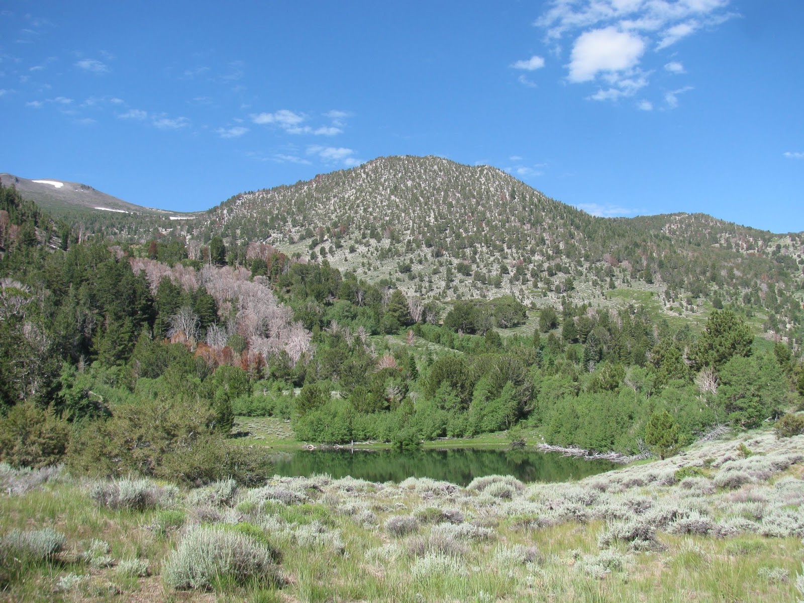
As we push, we gain some elevation above the pond and are treated to a wonderful view of the small water hole from above. The trail meanders through a large scree field before hitting a higher treeline, where large patches of snow remain from the long winter. Even now, in late July, the white carpet covers sections of the this northerly-facing hillside. We make our way through the mess until we reach the steepest part of the route, which has us climbing about 400 feet of scree at a 35-40 degree incline. While challenging, this class 2 terrain is much easier than the class 3 I did last weekend.


Reaching the final ridge-line, the summit of Mount Rose comes into site. A number of other hikers sit and admire the view. I noticed them wondering where we had come from as we approached them from the completely opposite direction they must have taken to reach this high Sierra peak. No matter, we relax at the summit and enjoy some lunch before planning our return. One of party had left a car at the standard trailhead and as I have someplace to be in a couple of hours I ask if he would mind my coming down the standard trail to his car and then catching a ride back to my jeep at the park. He graciously agrees.

We bid the other members of our party, who intend on returning the way we came, goodbye and being making our way down the mountain. This route is about a mile-and-a-half shorter  and only looses about 2,500' of elevation as opposed to the 4'600 we gained coming up the way we did.


As this is by far the more popular route to the summit (and back), we encounter a number of friendly hikers on our way down. Reaching the Galena Creek Waterfall, which flowing nicely, we realize we only have a little over two more miles to go before reaching the parking lot. All of us ready to get back, we hasten our pace and reach the car a short time after passing the falls.

I check my tracker and see that this mixed route carried us about 11.5 miles total (6.5 from the park to the summit and another 5 from the summit to the trail head). We pack ourselves into the car and head back down the mountain. It was a nice hike and I'm glad to be able to check that route off of my to-do list, but it doesn't ease my soul any and the pain of loss continues to well up inside me.

Saturday, July 20, 2019

Picayune Valley (Placer County, California)


I've hiked so much of the area around Lake Tahoe over the years, but I've never really explored the Granite Chief Wilderness on the northwestern. When I saw a hike listed on one the meetup groups I belong to pioneer a route through the Picayune Valley, I thought it would be a great chance to see this remote area.

Meeting the group on the west side of Reno, seven of us headed to the Squaw Ski Resort in Olympic Valley in four vehicles. We dropped two off and then traveled a few miles down the road to Alpine Meadows, where we met  up with two more hikers at the Five Lakes Trailhead. From here, we headed up the mountain and along Five Lakes Creek. The organizers had mentioned a report they had found last night that describes a river crossing further along part of the trail that may prove problematic. Luckily, I brought my water shoes, but some members of the group were a bit concerned with this development.

As we joined the Pacific Crest Trail for a short distance, the three hikers concerned with the river crossing decided to depart our group and make for a different destination with a little less adventure. We wish them well and continue on to our fateful exploration of this seldom visited valley. 


When we ascend the ridge, we note the hillsides covered with milkweed and mule ear, which are blooming into a marvelous yellow field. To the south, the valley carved out by Whiskey Creek opens up with gorgeous views of the Sierras. Off the north side of the ridge, the valley we intend to explore lays broad and potent. The Picayune Valley runs a few miles south to north until it abruptly ends at the Middle Fork of the American River and a steep cliff-side below Granite Chief.

While we carefully watch the track of our descent into the valley, Paul, who planned the route, remarks about their being many more fallen trees when he hiked this area last summer. Apparently, some individuals generous with their time and labor have visited since then and cross-cut many of the fallen trees to make a clean passage down the hillside and through most of the valley. In the valley itself, we pause to examine some long-abandoned pioneer cabins left to the ravages of time (though they seem to be holding up pretty well).


As we reach the area below a rock formation, the organizers refer to as the Cathedral, we pause for a short time for some pictures. I note the large quartz veins in the rocks beneath my feet. Looking up at the Cathedral above, an awesome piece of granite explodes out of the green hillside. Having vacationed in New Orleans just a couple of months ago, I'm reminded of the famous St. Louis Cathedral and the resemblance to it.


Just a short distance further down the trail, where the creek cuts carves a channel out from the stone valley floor, we decide to break for lunch. I enjoy a protein shake and some Nature's Bakery fig bars, while chatting with some of my hiking companions, John, Rob, Terry, Jim, and Paul. We rest for the better part of an hour and I explore the area just below us and the waterfall that delivers the water to it. It's a one beautiful little site in this broader expanse of beauty. 

We finish our lunch and push on until we reach the northern end of the valley and the Middle Fork of the American River. Contrary to the reports we had, the river crossing is not as terrible as we had been lead to believe. I swap over to my water shoes and with the aid of one of Paul's hiking poles, I maneuver past the large boulders and through the frigid and fast moving water to safely reach the other side. 


From there, the trail disappears and we follow the approximate track that Paul took up this hillside last summer. It's quite challenging for most of us. There is no trail and we are forced to find our way through dense bushes (mostly small manzanita), patches of pulverized granite sand, and the occasional boulder to take a hand hold on. This is certainly class 3 terrain as we are forced to use our hands for the majority of the ascent. With the sun exposure, I begin to feel light-headed and show symptoms of light heat exhaustion. I'm forced to break often as we climb. 


It's taxing and truly kicks my butt, but I finally reach the top. I tell group that I need a few minutes to recover before moving on. I take the time to hydrate myself and relax. After ten of fifteen minutes, I feel well enough to continue, but I know that I've lost the bulk of my energy on this ascent. I warn my companions that I may be slow as we continue on.

From there, the trail is relatively easy as it undulates along the ridge top making our way toward the backside of the Squaw Valley Ski Resort. I am disappointed though, when at every turn, the trail continues gently upward instead of downward, which would be much more to my liking.


Finally, we reach the resort and make our way to the gondola that will carry us down to the bottom of Olympic Valley. It's been one hell of a hike, likely the most difficult I've done this season, but I'm glad to have explored this area. We hiked 17.3 miles with a total elevation gain of around 4,500' of elevation gain, a thousand feet or so of which was the ascent of that steep wall. Paul suggests grabbing some dinner before we part ways, and my stomach being open to a meal, I and two others take him up on the idea. 

Saturday, July 13, 2019

Davis Moonlight Half-Marathon (Yolo County, California)


I've been on a streak with half-marathons this year, having run at least one each month this year. Wanting to keep it going, I searched for a nearby run to participate in during the month of July. The Davis Moonlight Half-Marathon seemed as though it would fit the bill. After leaving a wine tasting with some friends in Reno, I headed over the pass towards Davis and arrived around 6:00 PM. With the race scheduled to start at 7:30 PM, I should have plenty of time, but my concern is much more focused on the heat. As I drove through Sacramento, the thermostat was registering 104 degrees . . . ugh.

As race time approached, I checked again and it was still hovering around 90, but I was set on giving it my best go. To be honest, I haven't been running much in the past couple of weeks just because of life being pretty busy, but I'm here now. With the countdown from 10, the half-marathoners were off. There appeared to be about 300 hundred of us doing this distance, which is a pretty small group for an event, but it should be fun nonetheless.


Making our way through the city trails of Davis in this heat, I quickly recognize that I shouldn't have come out of the gate at my normal half-marathon pace. I'm quickly warming up and I'm forced to walk and cool down after just a couple of miles. Reaching the first aid station, I soak my bandanna in ice cold water and put it back on my head. This helps a great deal and I'm able to get back to pace for another couple of miles.

As the sun begins to drop below the horizon, the temperatures begin to cool off to the mid-80's, which is still much hotter than what I normally run in. However, I'm more focused on another problem. I wore my sunglasses for the run, thinking between the moonlight and my headlamp, I would be able to see okay once it started getting dark. The alternative was to wear my normal glass and be blinded by the sun during the first hour and a half or so, and deal with them shaking on my face the entire race. I chose the sunglasses thinking it was the better option, but I didn't consider that much of the course is under the shade of trees, which block out the moonlight. I can choose to run with my sunglasses on and my distance vision in tact, or to remove them and be able to see the world, but in blurriness. I opt for the later. I'm forced to walk a great deal of the course to prevent my self from tripping. 

While it does circle back on itself a number of times, the course is actually pretty nice and is highlighted by running across a bicycle bridge over interstate 80 to park on the southern side of the highway. We run a couple of miles in the park and then return across the bridge to the finish line. I'm extremely disappointed in my performance, running a 2:47:50, but I didn't die of heat stroke and so there's that.

In Search of the Mountain of Hieroglyphics (Lyon County, Nevada)


About a year ago, I learned of another ancient Native American petroglyph site in northern Nevada called the Mountain of Hieroglyphics. I've spoken with a number of people about it and done a fair amount of research. From everything I've found in my research, the site is on a hill on the western side of Lahontan Reservoir directly across from Fisherman's Point. During the winter months, I did a little exploring in the Jeep trying to find some back roads leading to this remote area, but end up just running into dead end after "No Trespassing" sign after dead end. I thought I would wait for the summer months when the reservoir's water might be warmer and shallower and then float across. However with the record snow falls this past winter, the lake level is higher than ever and it would be quite a trip for a poor swimmer to get across. 

This morning, I decided to take another crack at locating the site in the jeep. Similar to last time, I ended up falling short a number of times on a several different jeep trails, but eventually, I found the right path, though a large sand bar on the route made me decide to leave the jeep behind and to continue on foot. 

I followed what I would loosely call a road for a short distance before heading uphill towards a number of large boulders that might be home to rock art. It's a hot day and I'm concerned about rattlesnakes shading under the bushes and rocks of this hillside, but luckily I don't encounter any. I continue on around along a long steep ridge, but never see any rock art. Unfortunately, I'm on a schedule today and have an event to get to and I so, I'm forced to cut my search short and I'm not able to explore the most likely area for the rock art panels.


As I start heading down the hillside, I notice an obviously man-made wall overlooking a wash below. This was likely a hunter's blind, but I don't have the expertise to be able to even take a guess at the age of this. Regardless of whether it is modern or more ancient, I can imagine hunters hiding behind this wall and laying wait for antelope or deer to pass by below in the wash. After this find, I even more encouraged that there may be more history to be found here, but it will have to wait for another day, as the 1.8 miles I've hiked will have to be my limit today.

Sunday, July 7, 2019

Pluto's Cave (Siskiyou County, California)


Staying in the general vicinity of Mount Shasta, my other destination for today's little adventure is a lava tube known as Pluto's Cave. The drive is another hour around the mighty mountain to the northwest side, which is reminiscent of Nevada due to the rain shadow cast by the prominent 14'k behemoth. There is still tons of snow on the mountain and it makes for some majestic scenery. 

After driving a short distance down a sandy road, I arrive at the trail head. According to the map provided, the entrance into the cave is only about a third of a mile beyond. Unfortunately, a maze of trails has been cut through this desert environment and I find myself off the main trail before long. Luckily, it seems they all go to the same place. I am very watchful for rattlesnakes though. It's a warm day and there are a great many rocks and bushes along the way that would make perfect shading spots for these vipers.


Finally arriving at a collapsed section of the lava tube that allows entry, I scramble my way down the volcanic rock and size up the situation. To my left, a very large chamber that appears to be a party spot for locals, as there is some graffiti on the sides of the cave and a fire ring below. To my right, a small section of the tube's roof now forms a natural bridge about forty feet wide, but I can't see from here what lay beyond. I opt to to left first.


This section of the cave is pretty massive, with the ceiling approximately eighty feet above me. After just a few steps, I can see another collapse on the far side of this giant room. It doesn't appear to be navigable in that direction. The foul smell of bat guano permeates through this chamber and I opt not to stay long, though the room is magnificent.

Heading back the other direction and under the bridge, I encounter a mother with her two teenage daughters. They inform me that just beyond the bridge I will find a much deeper section of the lava tube and ask if I brought a light. In fact, I brought three plus my smart phone. I make my way that direction and after climbing over and through a number of dusty rocks, end up at the mouth of the final section of the lava tube. I can tell because the air coming out of there has a chill on it, much colder than the air temperature outside. Making my way in I find more graffiti and lots of dust. The cave floor and the rocks that it's comprised over covered with a thick layer of very fine volcanic dust. As I step, it stirs into the air and chokes me a little bit. I turn my lights on and carefully make my way into to bowels of Hades, all the while expecting to see Persephone and her lord husband bursting out of the darkness. 


As I'm alone and this is a pretty remote area, I decide not to venture to deeply into the cave before turning back. Perhaps I will return another time with friends and explore further into this natural wonder. As there is no GPS coverage inside the caves, it's difficult to know how fare I hiked, but I suspect it was about 1.6 miles in total. Very short, but very cool.

McCloud Waterfall Trail (Siskiyou County, California)


With all of the snow this winter, it's not surprising that many of the waterfalls in California are still flowing strong. One such waterfall, which I've head of, but yet to visit, is McCloud Falls. In fact, McCloud consists of three waterfalls, a lower, a middle, and an upper. Since I have the day off, I decided to make the drive up to the Mount Shasta area and explore this area.

It's a 3+ hour drive to the trail head and since I wanted to get at least one other stop in today, I got an early start, leaving my place just before 6:00 AM. The drive up US-395 through Susanville and then over CA-44 past Lassen Volcanic National Park was uneventful, but provided some beautiful landscapes. There is still a great deal of snow on Lassen Peak and Mount Shasta, as well.


I arrived at the trail head for the Lower Falls about 9:30 and after getting my bearings, started down the well maintained trail, which follows the McCloud River. After descending a set of steps, the lower falls is just below the parking lot. I'm here pretty early, but a few people fishing beat me to it. The lower waterfall has carved a channel in a short cliff and drops about twenty-five feet into a large, broad blue pool. I hear from some locals that the fishing here is outstanding with trout being the dominate inhabitant. I snap a few shots and then move on down the trail.


From the lower falls, the trail first follows a paved path as it wanders through a campground, but soon the pavement turns to dirt and as the trail continues along the river forming a wide upside down letter W. In all cases the trail is very well maintained and easy to navigate. The distance between the lower and middle falls is nearly a mile, but as I approach, it is obvious that this middle waterfall is far more spectacular than the lower one. A sheet of flowing water plunges fifty feet or more into a large pool and spans the widget of the river, perhaps a couple of hundred feet. To the right of the main waterfall, another flow cascades down a set of rocks. I decide to climb our a little ways over some fallen trees and rocky hillside to get a better shot. This truly is a magnificent waterfall, rivaling Burney Falls to the south. As I prepare to move on, a young family asks if I will take a picture of them with the waterfall in the background, which I'm happy to do.

The trail between the middle and upper falls is shorter than the previous section, but gains quite a bit of elevation as it has to climb the height of the middle falls and then some. Wisely, the trail builders put in a set of long switchbacks to help make this popular trail less daunting. After making my way up to the top, the trail follows along a stone cliff-side before finally opening up at the upper falls viewing area. A number of other hikers/site-seers are already taking in the beautiful waterfall. This one is similar to the lower falls, but set at an angle, which makes getting great pictures a bit challenging. I do the best I can though. This waterfall bursts out of the cliff with explosive force and drops twenty-five or so feet into another large pool, before heading down river to the next section of this gorgeous little river landscape.


I take a few minutes to bask in the sun and the glorious landscape around me before returning the way I came along the trail. The return is easy, as it is all down hill, and I'm reminded that I made the right choice to get here early, as the trail is starting to get pretty busy. When I finally reach the jeep, I see I've covered about 4.6 miles on this little waterfall journey. It was well worth it, but now I'm off to my next adventure.

Thursday, July 4, 2019

4th of July Fireworks from Jessie's Peak and Chickadee Ridge (Washoe County, Nevada)

 
 *Photo courtesy of Google Images

Last year, I spent Independence Day on top of Incline Peak overlooking Lake Tahoe with one of the Meetup groups I often hike with. It was an amazing experience and seeing five fireworks shows simultaneously at different villages around the lake was unique in my 4th of July history. When the group scheduled a similar event this year, I jumped on the chance to go again. Unlike last year though, this year the plan was to hike up to Jesse's Peak, the highest point on Chickadee Ridge. This peak is a couple of miles east of and a couple of hundred feet lower than Incline Peak, but should offer very similar views if the Lake Tahoe holiday festivities.

Meeting at the Sierra Summit Park and Ride around 6:45 PM, the 26 of us carpooled up Mt. Rose highway to the Incline Lake Parking area. Knowing it would get much colder at 9,200' after the sun goes down, everyone packed a few layers. In addition, the group always packs a nice spread of snacks and adult beverages. I ended up bringing two bottles of wine, some hummus and pretzels and some Jarlsberg cheese, which ended up making for a very heavy little pack when added to my standard day-hiking gear.

Surprisingly, there is still a fair amount of snow in the forest up here. Though the ridge we travel on is slightly south-facing, it is pretty heavily forested, meaning lots of shade to help save the snow. It's also worth noting the Forest Service's efforts to eliminate the small underbrush in this area that can be dangerous in terms of wildfire fuel during the summer. The really have done a nice job of cleaning most of it out this year. Through this section, we don't really have a trail, but it's really difficult to get lost in this area and many of us have a lot of experience hiking, snowshoeing, and skiing this ridge. Eventually, we meet up with the Tahoe Rim Trail for a bit and follow it to the base of the very steep northwestern side of Jesse's Peak. From this point, we scramble over and through more snow banks and many large granite boulders before reaching a large clearing on the top.


From here, we find a big flat granite slab that will serve as our table for the evening. Everyone huddles around it and starts unpacking food. I open a bottle of wine to share and start taking some great shots of the sunset over Mt. Rose and Relay Peak to the west. I'm always amazed at friendly this group of people are. While there are a lot of newcomers this trip, I think we make them feel incredibly welcome, as we all fill our bellies with the feast we brought up the mountain. I comment that people really need to eat and drink everything because I don't want to carry it back down. Others nod in agreement. 

As the hour gets later and night sky above Lake Tahoe darkens to reveal a beautiful starscape, we begin to see fireworks in the distance. First around Tahoe City, then at Glenbrook. Next Carson City to the east and Reno to the northeast. We are couple of thousand feet above the shows and in some cases twenty or thirty miles away, but it doesn't diminish the spectacle at all. In fact, seeing so many fireworks on the shores of the amazing Lake Tahoe simultaneously, enhances the evening beyond words. While there is plenty of friendly chatter, there are also moments of silence as we all watch with wonder at the celebration of the birth of our Nation, some 243 years ago. 

Finally, the firework finales cease and the group begins to pack up our waste and gear in preparation for a trip back down the mountain. It was still quite light when we arrived, but now we will be traversing this rugged landscape in the dark. Luckily, we all brought headlamps and other light sources. It requires a bit of route-finding, scrambling, and even some glissading down the snowbanks, but we arrive back at the cars safe and sound after the 4.3 mile round trip. It's a bit after 11 PM and having to work tomorrow morning, I need to get myself home and into bed. That said, I wouldn't have missed this wonderful tradition with such great people.