Sunday, September 26, 2004

Half Dome (Yosemite National Park, California)

In coming to Yosemite this weekend, our number one target was the mighty Half Dome. To accomplish our objective, we rise at 4:30AM and begin to break camp. Amazing how cold it is this time of morning when you crawl out of the sleeping bag. We pack up, grab a bite, and begin the thirty minute drive to the Yosemite Valley.

By 7:00AM, we are underway on what would become one of the most challenging things I had ever done. We use some stones to make our way across a small stream and to the main trail. With water and rations packed, we begin the long trail which circles around and then ascends the back side of Half Dome.

After a couple of miles of relatively easy hiking, we reach Vernal Falls, which comes jutting out of a sheer cliff like a spear from the hand of the mighty Achilles. At this point the torture begins. A set of steps, hundreds and hundreds of them, have been carved into the adjacent granite face. And so, we begin to climb. My left knee has been weak since a high school soccer injury, and these steps put it to the test.

Finally, we reach an area where the trail seems to level out again, but the damage is done. My knee is already starting to ache and with only four miles traversed. I convince myself to ignore it. A short time later we reach the Nevada Fall, similar in appearance to Vernal, but no less spectacular. We stop to take a short break.

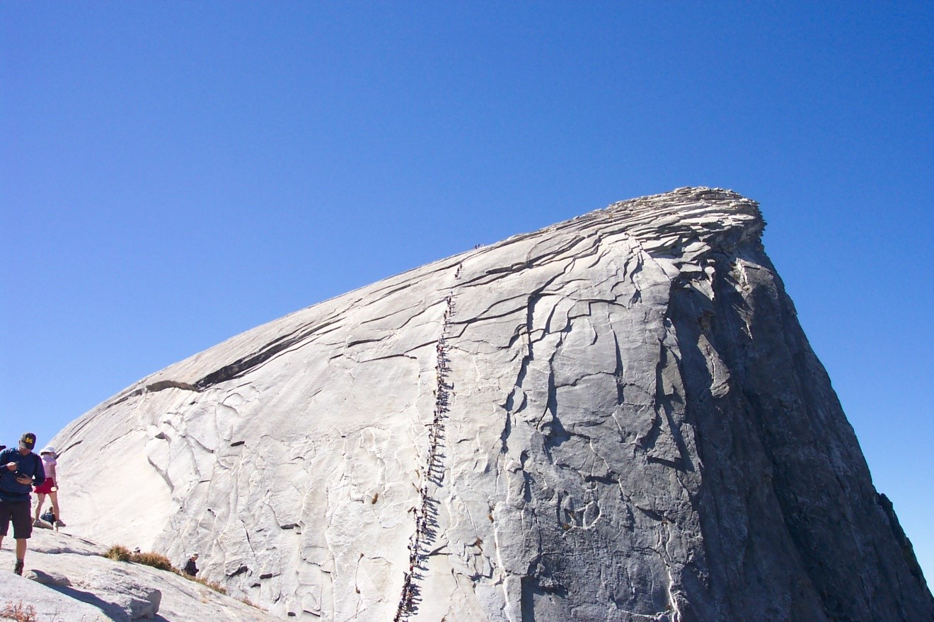
At about seven miles in, we begin to gain elevation at an exhausting rate. My view of the Eastern shoulder of Half Dome is somewhat worrisome, because I can see many more stone steps. I fortify my resolve and push onward, telling myself that I will reach the top at all costs.

My knee continues to be a source of great pain as we reach the cables. At about 55 degrees, the ascent up the side of Half Dome would be impossible without the 800 or so foot span of steel cables to sue as hand grips. A pile of gloves reminds Jason and me to pull ours out of our packs. I believe that each one of the hundred or so people climbing the cables realizes that one false move would surely lead to their death, as the drop-off on either side would prove fatal.


After about 45 minutes of cable-climbing, we reach the top. I head for the edge where I can look down 4,000 feet, nearly a mile, to Yosemite Valley and our starting point. I truly feel as though I have accomplished something by climbing this peak, named for its geometric shape. From the highest point, I look over the edge of a sheer cliff into the valley, a mile below. Even after skydiving, this sends shivers down my spine.


We spend an hour or so at the top, reveling in our accomplishment and then begin the trip back. Coming down the cables is far more frightening than going up them, but we eventually make it. My need progressively gets worse until I decide to tie a ripped t-shirt around it. Jason fashions a walking stick for me along the way, but by the time we reach my truck, I can barely move my leg. I look back up and have no doubt that the pain only makes the experience mean that much more. In total, we hiked 18 miles with an elevation gain of 4,800 feet. This hike is not for the faint of heart, but has reminded me that willpower can overcome any obstacle.

Friday, September 24, 2004

Camping at Yosemite (Yosemite National Park, California)

My friend and fellow adventurer, Jason and I set our sights on Yosemite. We had both visited the National Park before, but were determined to conquer it on this campaign.

Before setting up our camp, we took a short hike through the Mariposa Grove of Giant Sequoias. Although I have seen the behemoths before in the Calveras Grove, they never seem to disappoint. The magnitude of these specimens is comparable, but the grove has a unique feel to it.


Many trees catch our attention such as the Fallen Monarch, the Bachelor and Three Graces, which posses the placement of a certain famous painting based upon mythology of the Trojan War, and the California Tunnel Tree, which has been cut in such a way as to allow the trail to pass through its trunk. The patriarch of this grove, however, is the Grizzly Giant. Like something from Tolkien’s mythical Lothlorien, this tree rises from a semi-charred area to cast its giant shadow on the ground below. At a height of about 80 feet up, a large branch splits off from the trunk. This branch, however, has a diameter of nearly seven feet; larger than many giant redwoods . . . surreal!

After our short hike, we return to the Wawona Campsite to set up the tent and prepare dinner. While Jason collects some firewood, I prepare some skewers for our bratwurst. A good campfire is one of those precious memories that we cherish for a lifetime, and this is one of those. The crackling embers, the smoky taste to our meal, the incredibly warmth emanating from the flame all add to the experience.

Later that night, I venture out of the tent into a nearby clearing. A glance skyward reveals a majestic view of the stars, unparalleled in my travels. Their number appears to be endless, as if infinity has been demonstrated. After gazing for a short while longer, I return to the tent and enjoy a peaceful rest.

Friday, September 10, 2004

The Beach at Gulf Shores (Baldwin County, Alabama)

My friends Matt and Rachel have been trying for years to get me down to Rachel’s family’s beach house. And this year, all of the pieces seemed to fall into place. I decided to take some vacation time and join them there over Labor Day week.

Once I arrived, I could not have been more sorry for not visiting this place sooner. Gulf Shores is a tropical paradise. The house, which I stayed at, ahs an unobstructed view of the white, sandy beach, which it sits no more than a hundred yards away from. The bluish-green waves roll in carrying a warm breeze from the Gulf of Mexico.

Lounging here on the beach is one of the most relaxing experiences of my life. I feel at peace here as I pick up a handful of the plentiful sand and watch as it slowly slips through my fingers. Unlike my experiences in Houston, where the water was brown and murky, the ocean here is very clear and amazingly warm. The gentle sound of the waves crashing into the shore only adds to the serenity I feel in this place.


Saturday, September 4, 2004

Bourbon Street (Orleans Parish, Louisiana)

I’ve always thought of the Las Vegas strip as the locale of the greatest Saturday night public parties. That is until I stepped foot on Bourbon Street for the first time. The only relevant analogy I can think of would be that of a parade of army ants marching to restock the nest’s cupboards. However, the human traffic on this small street in the French Quarter of New Orleans is not marching towards food, but marching to the next place that catches their attention with the promise of a good time.

The street itself is no more than a two-lane street with relatively wide sidewalks. The main area of the constant festival of Bourbon Street is concentrated in one area approximately 8 blocks long, but tends to spill out over onto the cross streets and even the streets running parallel to Bourbon, within the Quarter. This entire area, meaning practically every street, is like something frozen in time. Many buildings are two or three hundred years old and remain original in their outward appearance by city ordinance. Unlike the majority of the shop’s original businesses, nearly all have been converted into eateries, taverns, novelty shops, or clubs.


The French Quarter beats to the rhythm of its own distinct drum. The mix of cultures here is quite startling. From the Voodoo culture of Haiti and Jamaica to remnants of culture from the French courts in Paris, this place is alive.

Food, like every other aspect of this combined culture has elements of each parent culture, but has over time, developed into the harmony of Cajun and Creole cuisines. I have tried dishes like fried alligator, steamed crab claws, beef brisket, Jamaican jerk chicken, Cajun seafood gumbo to name a few. All have a distinctive flavoring and are infused with part of the love that people have for food.

As I have read a number of Ann Rice’s Vampire Chronicles over the years, I was a bit excited to have the opportunity to participate in a “vampire tour” through the French Quarter. Much of her interest and inspiration for her books came from local legends, which are told by the very knowledgeable tour guides as the group looks on at the houses where some of these strange, unexplained murders took place. While the guides do not try to sway your belief in vampires one way or the other, they simply end the tour by telling of how their own beliefs have become a little more open-minded since researching the rich and speculatively-supernatural history of this great city.

Sunday, August 29, 2004

Lover's Leap (El Dorado, California)

As I write these words, I am sitting on the summit of a shear granite face, known as Lover’s Leap; quite an obvious name for a point such as this. Leaning over the rock I’m sitting on, the objects in the valley below, some 700 ft down appear as ants on the pavement. This area provides breathtaking views of the American River Valley and a bird’s eye view of the charming little hamlet of Strawberry.

I can certainly see why the local signs speak of a rock climber’s paradise. While I took a relatively easy trail to get here, I felt a bit squeamish as I ventured along the crumbling granite overhangs. The steepness of these faces would be enough to induce a heart attack in those so prone. Add to that, the sudden gusts of wind, which suddenly seem to be at home up here and I too feel the need to constantly double-check my footing.


One can’t help but feel a bit divine up here. Looking down on the lowlands, must be something like looking down from Heaven.

Thursday, August 19, 2004

Lagomarsno Canyon Petroglyphs (Storey County, Nevada)

When I first heard of the existence of prehistoric rock art so close to my home, I instantly wanted to visit and see this small window into the past. Lagomarsino Canyon is about thirty miles East of Reno and about twelve miles North-East of Virginia City, but that is not to say it is easy to get to. Some of the roughest roads I have ever encountered must be traversed to reach this canyon. Only through my friend Jason’s skilled driving and his fiancĂ©e’s 4X4 were we able to reach this location.

While there are a number of stone walls scattered along the hills here, the petroglyphs themselves are scratched into the large basalt boulders of a cliff on the North side of the canyon. From what I am told this short, but jagged cliff was used by Native Americans to run game to their deaths. It seems perfect for that purpose.


According to a sign at the base of the cliff, many of the primitive motifs appear to be 4,000-5,000 years old, but some may be as old as 10,000 years. There are many recurring themes: wavy lines, geometric patterns, and wild life. By doing some very basic rock climbing, we are able to see nearly one hundred images.

As with anything of this nature, the explorer cannot help but ask some basic questions: Why were these drawn? By who? And what were the artists like? Perhaps, they were drawn by mere children, trying to express themselves or perhaps, by a group of men who had not yet found their place in the world and were simply trying to tell future generations that they had existed. We may never know for sure, but I suspect their purpose for creating such marks in time may not be much different than our own.

Saturday, June 19, 2004

Black Rock Desert (Washoe County, Nevada)

This trip had nothing to do with hiking and everything to do with an exercise in freedom. The Black Rock Desert is a strip of completely flat, completely lifeless land North of Gerlach, NV. It is approximately 120 miles long running north to south and 15 miles wide. This area is the site of the pagan summer festival known as “Burning Man” and was the location of the most recent land speed record run.

I find a launch point and drive out onto the white, sandy playa. I’ve been told that driving on the surface when it is wet is a sure way to be the talk of the office after having your truck airlifted out of the muck. Understandably, I proceed with caution. I’m amazed at how comfortable my truck seems on this terrain. I accelerate to 40; to 50. I accelerate still more to 60; now more . . . 70 . . . 80! Eighty miles an hour with no road in site and no rhyme or reason to the path I’m driving. I veer, I swerve, no need to worry about obstacles here. This must be what space is like.


To continue that analogy, I notice that there is absolutely no echo when I speak, after stopping to take a few photos. I pack the camera, and proceed to start looking for a way back onto the road. This is only the first stop of a long weekend.

Wednesday, June 16, 2004

Kayaking from Sand Harbor (Washoe County, Nevada)

Sand Harbor, on the Northwest Shore of Lake Tahoe is an idealistic destination for a novice kayaker, such as myself. The Sandy beach, which acts as a terrific launch point is covered by white granite grains, a bit larger than white sea sand, but with a comfortable texture to walk on nonetheless. So alien does this white beach appear in this alpine setting with snow-capped mountains in the distance, that I had to ask my companions, Jason and Craig, if it had been man made or if it was natural. Natural they both replied with a proud smile.

The famed water of the Caribbean cannot possibly be any bluer or any more clear than the cold waters of Lake Tahoe. After launching, but still within the boulder-filled harbor, I am amazed to be able to see the lake bottom at a depth of fifty to seventy-five feet. If not for the frigidness of the water, I would be tempted to dive in and practice my non-existent scuba skills.

Pathways through the large granite boulders provide an amateur obstacle course for practicing my maneuvering techniques. I manage my way through with few collisions and we continue down the shoreline.


At about half-a-mile, we encounter the antiquated Thunderbird Lodge, a holdover from days past and a popular site of local weddings. The grounds are practically littered with small boathouses and servant’s quarters, all surrounding the main stone structure. When this served as a private residence many years ago, how lucky the inhabitants must have been to awaken to this view of the lake.

We continue on darting away from and toward the shoreline in alternating coves for some more obstacle course practice. I stop to take a couple of shots with my trusty camera, after fiddling with my spray skirt and the waterproof box that contains my valuables.

Around the next point, we reach Chimney Beach, so names for the lone remnant of the former structure placed on this sandy shore and boxed in by vehicle-sized pieces of granite. The local wildlife and remaining tenants of this home-that-was, a group of six or seven chipmunk-lie creatures, come out to beg for some of our nutritious snacks. As I comment about the tameness of these chipmunks, which are now within inches of us, I am corrected and informed that the little miscreants are actually a small shore-tailed form of squirrel. We clean up our trash and that of some former visitors and begin to make the long trek back to our launch point.

The waves here are not only as blue as the sky, but seem to contain no smaller ripples within, as jiggling gelatin in a desert dish.

In total, we paddled approximately three miles and my arms are somewhat sore, but what a marvelous day. This must be the most beautiful lake on the face of the Earth.

Sunday, May 16, 2004

Loch Leven Lakes (Placer County, California)


To get to this trail head  I had to drive down a road, which runs alongside the south fork of the Yuba River. There are houses built all along the granite slabs, which provide the terrain for a series of amazing waterfalls and rapids.

Once parked, I made my way up a trail cutting through the granite. It was very open here, with visual expanses carrying for miles into the mountains. The hike had been challenging so far because of the elevation gained, but not too bad. The trail is a bit difficult to discern, as there were large gravel areas that can be easily mistaken for the trail. Some helpful adventurers help me find the current path, as we pass each other.

In the distance, I begin to see a clearing. This clearing is, in fact, a small, solitary pond. The shore alongside the pond would make an ideal place for a summer picnic. The air begins to smell of pine; a fresh scent, which is fairly unfamiliar to urbanites.

As I make my way around the peaceful drop of water, the sound of nearby waterfalls approach the limits of my earshot. The anxiety of seeing the falls up close fills me. At this time of year, the snowcap of the mountain above is making steady progress towards melting away, which means the mountain streams and rivers are at full force.

The trail leads through a small grove of pine trees using cut timbers to line both sides of the trail and then just ahead a granite cliff slowly takes form. From the cliff top, I am looking down over an absolutely incredible set of falls. One after the next, they exit the fast moving river water as it is joined by countless small and medium trickle-down streams. I explore the cliff side and find an area close enough to catch some water. A handful of this crystal clear and near-freezing water and I am suddenly refreshed. Nonetheless, I decide to stop for a snack. This is a marvelous view; simply majestic is pureness and freedom of the river.

Time to continue on. I suddenly find myself on a snow-covered clearing, after crossing a small wooden bridge. Once again, the trail is difficult to find, but eventually shows itself. Ducking under and climbing over fallen pines, I make my way to the dual set of railroad tracks. As I understand it, these very tracks were part of the first trans-continental railroad. This is a rustic look into the history of this harsh land.

The path continues on the other side of the track and the air becomes noticeably chillier. What during the late summer months is probably a well-worn trail is actually a small creek at this time of year. For the melting snow it provides the path of least resistance. Negotiating this creek is very challenging as many areas are still covered by several feet of snow. On more than once instance my step causes the snow below to give way, resulting in my plunging waist-deep into the doomed snow. As this becomes more common, as the grade sharpens, and as my body begins to fatigue, I have thoughts of turning back. No! I will continue and see the alpine lake ahead!

It seems as though, I may never make it to the lake as I travel up switchback after switchback. Looking back at where, I started, I see, that for all essential purposes, climbed a mountain.

Must push on! The lake can’t be much farther now. Just about the time that thought enters my mind, the trail begins to steeply descend. Perhaps, I am almost here. I take a detour to a small hilltop and from there look out over Lower Loch Leven Lake, a truly amazing site. No visible piece of shore is cleared. One trees huddle around the football field-sized lake as if protecting it from all transgressors. Set here in the snow, as it is, I cannot help but think of the solitude and of the peace of mind that can come from occasionally solitude.

As I look to the sky, the late afternoon sun indicates that it is time to return to the trailhead. In total the trail was 5.1 miles long, but the exhaustion that overwhelms me, makes me think it may have been farther. This trail is probably much less challengin

Saturday, April 3, 2004

Cool to the American River Loop (El Dorado County, California)

At the beginning of the hike with my friend Jason (not Texas Jason), we were both a bit surprised at the number of horses on the trail. The trail itself starts out as a well-traveled dirt road along a lush, open field. To be honest we were both a bit concerned with the tameness of this trail at the onset.

A few hundred yards further and after a bend in the road, we encountered the first of the “tombstone rocks”. Like the memorials in an old west cemetery, they rose from the ground, but much more ancient in appearance. They are actually remnants of an ancient sea bed turned up during the upheaval at the formation of the Sierra Nevadas. They are dark gray in color, covered in moss, and many are shaped very similar to tombstones. It is obvious why they people of the gold rush era gave them this nickname.


A bit further on, we decided to be a bit adventurous and take one of the many smaller trails branching off from the main trail. Little did we know that we would not be alone. As we proceeded further on, we heard what sounded like the rustling of grass blades but turned out to be a rattlesnake warning us. We had passed no more than eight inches from him, but his color blended in well with the grass. When we realized his presence, we were understandably a little shaken, but I could not resist snapping a couple of pictures from just beyond striking distance. We continued on and left him in peace.

As we proceeded, we encountered many more cross-trails and small trickles of water from the snow melting. Finally, the energetic American River came into sight. We made our way down to the shore and climbed over some rocks until we met with an area suitable for a short rest.

The power of this river was truly amazing. I couldn’t help but venture out, wading into it. I cannot recall feeling water as cold as this in my entire life. It must have been only fractions of a degree above freezing. After only a minute or two of maneuvering over the sharp rocks with my bare feet, I was forced to head back to the shore. It felt as though a thousand tiny needles were being pushed into my feet. Burrrr!!


Once I had regained my balance on the warm shore stones, I had a sense of relief, but only briefly. I made the mistake of trying to take a step backwards. Little did I know that a thorn bush was directly behind me. As one of the sharp thorns poked me in the foot and I reacted to move away from it, my footing on the uneven stones gave way and I found myself sitting on my rear, with my hand snagged by several branches of the same thorn bush. I carefully got myself untangled with only a few scrapes and splinters to show for it and decided it was time to return.

We made our way back up the trail, but were unsure of the correct path back and so decided to follow the paved road back to Jason’s truck in the town of Cool.

On the way back we made one more attempt to return by way of the trail. We followed an unfamiliar trail back into the woods, only to find a ruined settlement beside a small cave. Being adventurous, as we both are, we could not resist the man-sized portal into the mountain. Luckily, he had a small keychain light to aid us as we walked into the darkness. As we went further in, the cave began to resemble more of a mineshaft. About a hundred feet in, the lone tunnel became a “T” intersection. Unfortunately, both ends of the “T” soon met with a dead end. The appearance of candles and beer bottles was a sure sign that this was a favorite hangout of the local teens. We headed back for the entrance, wondering what events had taken place in this small secluded pocket of the Earth.

We continued on, climbing up the stones of a steep mountain stream until we saw no hope of regaining the trail. We returned to the road and finally reached the familiar parking lot. This had turned out to be a strenuous hike with lots of adventure.

Sunday, March 28, 2004

Swimming at Surfside (Brazoria County, Texas)

I spent this weekend visiting my other friend Jason in Houston, Texas. One of the many items on my to-do list while in the area was to see the Gulf of Mexico. The drive to Surfside Beach takes about two hours from Houston, but is well worth the investment.

After paying the parking fee, we drove out onto the white, sandy, seaweed-covered beach to find a decent parking spot. I say that seaweed covered, but in truth there was only a rim of seaweed on the shore.
My first look at the waters of the Gulf was a little surprising. The water was a sandy color, as opposed to the tropical blue, which I had envisioned. The waves seemed to continually crest and roll into the shore. The sea is untiring.


I couldn't resist the chance to ride these small white caps. They were small, but a few of them swelled past five feet tall. I ventured out into the salty abyss, wandering about a hundred feed from the shoreline. There is an amazing difference in the water level between two waves, when the water level is near my knees contrasted to the wave itself when, I am lifted several feet off of the bottom.

The waves did not seem to diminish in either frequency or strength during the two or so hours that we spend there. However, there is something to be said for letting the ocean have its way with you. The sense of something greater than yourself is ever-present. As I allowed the waves to carry me, several of them struck me with such force as to allow the undercurrent to pull me under. One particularly strong wave had me doing flips under the water. The experience is exhausting.

I made my way to the shore in order to dry off and soak up some rays. I was surprised to see tiny clams digging back down into the sand after each wave uprooted them from their homes. Life is everywhere here.

After drying off it was time to head back to Jason’s house. Alas, my wave-riding adventures had come to an end.

Saturday, March 13, 2004

Kayaking at Pyramid Lake (Washoe County, Nevada)

As this was my first time in a kayak, I was understandably timid. My friend Jason who was accompanying me on this little expedition had taken his boat out onto the waters of the Sparks Marina the week before. He informed me of how unstable the long, narrow craft seemed at first. After a pleasant and uneventful drive to the lake, which is about 35 miles North of Reno, we arrived at the tribal police station and each purchased a recreational pass for the day

We first put in at a nice, calm beach that I had discovered the year before. I put my life jacket on, put the paddle together, and proceeded to carry the forty pound boat out to the chillingly cold water. While the air temperature on this beautiful, sunny day was in the low seventies, the water had barely risen above the memory of its long winter freeze.

As I committed my body weight to my sleek, red kayak, I found that Jason was indeed correct about the stability. The slightest lean could have catastrophic effects. I thought about how unpleasurable falling into that frigid water would be and assured myself that it would not happen.

Maneuvering a kayak is quite challenging at first. . It almost seems that the paddle is more of a hindrance than a help, but after a short time one begins to realize that the boat, the paddle and the paddler must become a unified being, if control and stability are to be established. That is not to say that I have achieved this level, only that I realize that I will need to.

We paddled around this area on the Southwest corner of the lake for an hour or so, never going more than a quarter of a mile or so from shore. As I was beginning to feel a bit more confident in my ability to keep from capsizing, I suggested that we reload the boats onto the rack I had fashioned in the bed of my truck and drive around to the other side of the lake. There we could paddle out to Anaho Island and the actual pyramid for which the lake had been named.

The acceleration of these man-powered boats is amazing. In no time we were back on the shore, loaded up, and on the sandy dirt road leading down to the Eastern shore. The road was challenging for my two-wheel drive and seemed to be about ten miles long. This area around the Eastern shore is true desert with practically zero vegetation. Finally, we traversed a rocky section of the road, moving as slowly and carefully as my truck would go, which seemed to herald the last hurdle before reaching the shoreline.

This side of the lake is muddier and more a home for algae than the other side. After doing my best to walk on the steep roads and slimy shoreline, we got the boats in the water and we were off.

On the calm waters of Pyramid Lake, distance is somewhat deceiving. We paddled at least a half-mile out to the stone pyramid. As we discovered, the stone pyramid is not stone at all, but instead a five-story tall mineral deposit. It smells of sulfur and feels like salt on a margarita glass to the touch. A fellow kayaker, who was trying his luck with a fishing pole, informed us of a water-level hot-spring on the far side of the feature.

Upon his recommendation, we traveled around to see the wonder. In comparison to the massive pyramid, the small human-arm sized outreach was barely noticeable. It appeared as white outcropping just an inch or so above the surface of the lake water. We took care approaching it. I first ran my hand under the surface of the lake directly under the hot water spout. The surrounding water had been significantly warmed by the spring. I was almost afraid of actually touching the spring water itself, but couldn’t resist. Ouch! That water had to be near boiling. What an amazing thing this is.

We made our way completely around the pyramid and then decided to make the now apparent, long trek to Anaho Island. It seemed like the thought, “we’re almost there” crept into my mind countless times before reaching the island’s ancient shore. In truth, it was about two miles from the pyramid and about a mile and a half from where we had left my truck, which now appeared only as a spec.

The shore of the large island was littered with tiny creatures’ shells, broken avian bones, and a hodge-podge of mineral-encased, fossilized rocks. I thought to myself, “when was the last time someone had stood upon this shore? Who were they? And, did they have the same wonder for the majesty surrounding them?” In the distance, I could hear seagulls sound the approach of dusk. It was time to paddle back and return home. As I loaded the boats back onto my truck and drove away, I thought and whispered to myself about returning.