Wednesday, May 26, 2021

Ash Springs Rock Art (Lincoln County, Nevada)

Continuing on our trip home from the Grand Canyon, my friend Gen mentioned another rock art site along our route that Nick, Chris, and I were unaware of. Ash Springs sits just about midway between Alamo and Crystal Springs along US-93 in southeastern Nevada. As we approach the area, we begin looking for a pull off, which we quickly find and though it is a sandy unpaved road and we are in a small two-wheel drive truck, we don't have any trouble following it up the small hill to a spot where we can park and then explore by foot. 

The site has a sign-in box that contains some information brochures. The map inside the brochure indicates numbered markers, which we quickly locate in and around the rocks here in the sagebrush-strewn desert. There are numerous panels on several boulders here. Most seem to be depictions of big horn sheep and antelope, but one in particular draws my attention. It is the image of a humanoid figure, but with hands above the head and fingers extending many times the relative length they should be and pointing to the heavens. Similarly, the toes are not proportional. This gives the image an otherworldly aura. It's quite stunning.

We spend twenty or thirty minutes walking through the sage brush and examining most of the panels. It's good once again to stretch our legs, but after a short time, we head back to the truck and continue on our way back to Reno. It was an excellent site and I'm very glad to have visited it.

Bloomington Petroglyphs (Washington County, Utah)


On our way back from our Grand Canyon adventure, I talked my friends into a making a couple of stops along the way. If nothing else, it's good for us all to stretch our legs. The first stop is a rather strange site. In a subdivision on the edge of St. George, UT, two giant boulders carved with ancient indigenous petroglyphs has had the tenth of an acre or so around it designated as Bloomington Petroglyph Park. It seems strange to see very nice residential housing surrounding the rock art, but as long as it is protected, I have no specific complaints about this arrangement. 

The boulder itself is covered with recti-linear and anthropomorphic designs, including one of the most perfect spirals I've seen in all of my rock art hunting. The flat vertical face of the larger boulder is home to the highest concentration of figures, but the petroglyphs are pretty much on all exposed sides of the boulders. We take a few minutes to examine them, before heading off towards Reno. It was a nice stop and great to stretch our legs while seeing this ancient art work.

Sunday, May 23, 2021

Grand Canyon Rim-to-Rim (Grand Canyon National Park, Arizona)

A couple of years ago, my friend Nick suggested that we should do a Grand Canyon trip to celebrate the 10th anniversary of our trek along the New Hance Trail. All of the original group were excited to complete this new trip, but after some discussion, we decided to make it a rim-to-rim-to-rim instead of retracing the original route. We each entered the lottery and were able to get our permit for the third week of May 2020. In March, a couple of months before the trip, the world began shutting down as the COVID-19 pandemic cast a dark shadow on humanity and travel was brought to a near halt. Our permit was cancelled by the National Park Service and our trip had to be postponed.


Luckily, we were given an advantage in the 2021 lottery drawing and were able to secure a similar permit for May 2021. However, two of the original members of our group decided they were not physically up to the challenge this time around and had to be replaced. Nick's brother Chris and my friend Gen happily agreed to join our little adventure. As the date or our departure approached, we finalized all of our plans and packed our gear in preparation. We had all been training pretty hard for the hike, knowing full well what we were getting ourselves into. I had decided to fly into Reno late Friday night and then drive down to the park with the rest of the crew. Gen picked me up at my hotel bright and early and we met up with Nick and Chris a short time later. After stuff all of our gear into Nick's truck, we hit the road - Grand Canyon or bust!

It's a long 11 or so hour drive from Reno to the North Rim and we passed the time by catching up with each other and discussing the adventure to come. When we finally reached our accommodations for the evening, we were all road-weary and ready for a good night's sleep. Unfortunately, that good night's sleep would be at a Demotte Campground just a few miles from our trailhead and the temperatures were expected to drop into the mid-20's overnight. While this was a chilling prospect, we had prepared for it and after changing into my Under Armour Cold Gear and slipping between my sleeping pad and backpacking quilt, I felt pretty warm. Nick had brought along some additional blankets for all of us to use tonight and I took advantage. That said though, it didn't seem to get all that cold overnight or perhaps, I was just well geared for it.

Day 1: North Kaibab Trail

We awoke, made breakfast, broke camp, and drove the ten or so miles to the North Kaibab Trailhead. The parking lot was full and we were forced to park on the side of the road. We arrived quite early (7:15 if I recall correctly), but with lots of over-nighters in canyon, it's really not all that surprising that available parking was limited.

After some final prep and gear checks, we hit the trail. This route would take us from the North Rim of the Grand Canyon, through the side canyon cut by Bright Angel Creek, and eventually to Phantom Ranch and tonight's planned lodging at Bright Angel Campground. The temperature is great for hiking this morning, sitting around sixty degrees. However, as soon as we hit the open sun, it begins to get hot. I picked up a veiled ball cap to help prevent getting sunburn on my neck and ears and while it serves that purpose well, it does cause some odd hearing issues as the sound waves bounce in unexpected directions off of the veil before entering my ear.


The Trail here is steep - very steep - as we descend into the grandest canyon in all the world. The surface is a combination of red sand packed to varying degrees with the occasional baseball or football sized rock buried for variety. I do note that my toes are hitting the inside of my hiking shoe and becoming pretty sensitive already. I had expected this, but was hoping it wouldn't begin so early. As a precaution, I put some tape on my right big toe, which seems to help a little bit.

As we make our way down the gigantic cliff wall, we encounter a few unexpected sites, including a waterfall pouring from a hole in the adjacent cliff side. I knew there were some water sources in the canyon, but this is unexpected. The powerful stream simply comes out of a hole in the canyon wall and proceeds to tumble down the multi-colored layers of the cliff before forming a creek towards the bottom.

After about six miles of this grueling downhill, we arrive at the Manzanita Creek Water Hole and Rest Stop. Here, we decide to take a short break for lunch, restrooms, and water refills. It's nice getting the pack off of my shoulders for a bit. I packed a bit heavy for this trip and brought a couple of luxury items, including a second sleeping pad and camp chair. While not completely necessary, they do make camping a bit more comfortable. With three liters of water and six days of food, I weighed in at around 41 pounds. Again, a little heavy, but not atrocious. Still, my body appreciated loosing that added weight if only for the few minutes we rest here. Once everyone has finished their snack and refreshed themselves, we continue on towards Cottonwood Campground.

Along the way, we cross a small suspension bridge that spans this side canyon. It's pretty cool to see this kind of thing here, as some of this would be impassable without some minor help from the civil engineers. I know I usually complain about "improvements" like this, but sometimes they are necessary. After just another mile-and-a-half or so, we reach Cottonwood Campground, which is our planned lodging for night four of this trip. The idea is that we'll do the entire North Kaibab Trail going down today, but on the back up, break it into a two day affair. As we pass through the campground, we note how small the designated campsites are. There is some concern that we wouldn't be able to fit all four tents in one campsite, but after looking them over, I assure the group that we can fit. Anyway, that's a problem for a different day. For now, we still have many miles to go before we bed down for the night.

From here, the trail flattens out for the most part. We are still descending towards the Colorado River, but at a much more shallow slope than before. Which means my toes get a chance to rest . . . just as I think that I end up accidentally kicking one of the large rocks in the trail . . . OUCH!!

Though flat and easy hike for these next eight or so miles, they never seem to end. The trail runs beside the creek as it snakes through and around this winding canyon. I suspect that my GPS reading is also getting thrown off a bit by the narrow walls of this canyon. That said, I can't fully trust my distances from this point. One bend after another has us thinking that Phantom Ranch will be right there. And time after time, we are disappointed to only find the next bend. 

Finally, we see the sign indicating that Phantom Ranch, which includes our campground, is only half-a-mile further. With all of us exhausted from many miles of steep downhill followed by many more miles under the baking sun, our pace quickens a bit and we begin to look for signage indicating where exactly our campground is within Phantom Ranch. The signs are not all that helpful and we are forced to guess at a couple of junctions. Fortunately, we guess well and soon find Bright Angel Campground. After looking at a couple of different options, we choose our campsite from the many unoccupied ones. The choice was based as much on how tired we were and our desire to not walk much further as much as the actual site itself. Still, it will serve our purposes.

We spend the next hour or so erecting our tents and preparing some dinner - vegetarian pad thai for me. . . yummy. After dinner and as the sun sinks behind the canyon wall, we admire the small bats swarming overhead. We watch as the jerk to and fro in mid-air as they gobble up any would be pests that might have designs on feasting on our blood tonight. The bats are a welcomed site. Temperatures are looking to be in the mid-to-high fifties overnight . . . great sleeping weather. While I decide to leave my rain fly off and admire the view, my comrades put theirs on to afford themselves a little privacy. By 8:30 or so, we have all turned in for the night and while I do rise once to use the bathroom and a couple of other times to turn over, admiring the stars above me while doing so, I get a pretty good night's sleep.

Day 2: Bright Angel Trail

I rise a bit before the sun and I think I'm the first to wake. I meander down to the bathroom to deal with morning business and when I return, Nick has begun stirring in his tent. As we know it's going to be exceedingly hot today, I really want to get an early start and begin taking down my tent while my breakfast cooks. The others begin to stir and soon, we are all packed, fed, and ready to hit the trail for our second day.


Today's route will take us across the Colorado River and up the Bright Angel Trail to the top of the South Rim. The crossing of the Colorado is the first thing of note this morning as our hike begins. At the bottom of the Grand Canyon, two long suspension bridges span the great river - the Silver Bridge and the Kaibab Suspension Bridge. We'll be crossing the Silver this morning and the Kaibab tomorrow on our way back across the canyon. The fast-flowing water of the river is unexpectedly blue today. The last time I was here, the waters were as red as the sandstone forming the canyon which they carved. They were also full of sediment, so much sediment that we jammed a water filter after only three or four pumps. While I wasn't planning on making that mistake this time, the river looks beautifully clear today. Perhaps a storm has recently come through last time I was here. 

As we approach the bridge, I'm in awe of the engineering here. This bridge spans approximately 450 feet across the Colorado River and connects the Bright Angel and North Kaibab Trails to complete a full corridor across the Grand Canyon. The bridge is designed to support hikers, as well as mule trains. Seeing it over the blue waters of the river with the rising sun as a backdrop is mesmerizing. I cross holding my hiking poles up so as not to snag the tips on the pathway. The bridge is very secure, but that doesn't mean I don't feel a little tinge of anxiousness as I make my way across.

Finally, reaching the other side, I look back and admire the ingenuity one last time. From there, the trail follows along the river for a little over a mile before turning south and heading up the next side canyon along the Bright Angel Trail. Far below us, we can see some rafters taking a rest along the river banks at one of the sandy sections. I'd kind of like to do that adventure someday, but not today, though I bet the cold water would feel very nice.


As we begin the brutal climb up the canyon wall, the sun rises overhead and begins to beat down on us without remorse. Switchback after switchback sees us rising further and further up the canyon wall. On the approach to Indian Garden, we pass above and by a small double waterfall in a tiny canyon below us. It seems out of place in this desert environment, but something has to water the sagebrush and yucca plants. It does provide some cooling effect and it's very welcomed.

About five miles from the bridge, we come to Indian Gardens. This area serves as a rest stop for both humans mules alike. There are restrooms, benches, water fountains, and much needed shade. As we pause for ten or so minutes, we admire the mule train that has also decided to rest here. There are approximately a dozen people in the train and as they relax in the shade, their mounts enjoy some nice cool water. It's a short stop for us though and after we refill our water, we're back at it and once again climbing the steep cliff side.

I lived in Reno, NV at about 4,200' for almost 17 years before moving to the Atlanta, GA area at 1,100' about a year and a half ago. When I lived in Reno, hiking here in the Grand Canyon wouldn't have phased me, but now, as we make our way up towards the 7,000' foot south rim, I can feel the early effects of acute mountain sickness or altitude sickness. Even sitting at rest for a couple of minutes, I have a difficult time catching my breath. It's worsened by the exertion of climbing this steep trail with forty or so pounds on my back. Meanwhile, Nick is beginning to get overheated. We encourage him to rest in the shade and drink plenty of water, but it doesn't seem to be enough. 

We stop several times on the last three miles of the climb, and for extended stops at both the 3 Mile and 1.5 Mile Resthouses. This last section is brutal for anyone, not just those experiencing heat exhaustion or altitude sickness. Endless switchbacks twist and turn as the trail makes it's way up the vertical wall of the South Rim. It reminds me of that scene in Return of the King, when Elrond is making his way to Theodan's camp to speak with Aragorn, though the trail here has many more switchbacks and is in shades of yellow and red, instead of the lush green hillsides in the film.

Finally, we reach the top.and rejoice. After resting for a bit, we start trying to figure out if a shuttle is available to get to our campground for the night, some two miles distant. When we approach the shuttle stop, we notice a sign indicating that the blue shuttle (the one that we would need to take) is not operating due to the pandemic. It looks like we have further to walk. Luckily, this is easy walking on nearly flat, paved bike trails. 


Before finding our campsite, we take a detour through the village market and pick up a few items for dinner, including some beer. It's not supposed to be nearly as cold here as it was on the North Rim two nights ago and a cold beer certainly sounds good after the physically exhausting day that we've just had. With our packs load back on our backs, we walk back to our campsite and begin to relax a bit before setting up our tents. As we prepare some dinner and chat, it becomes clear that Nick isn't sure if he can complete the trip. Temperatures at Phantom Ranch, which will pass through again tomorrow, are expected to be in the triple digits the next two days. While the elevation is still a minor concern for me, the longer I'm here, the more acclimated I get and even if I weren't acclimated, the symptoms were not severe enough to prevent me from making the return trip to the North Rim. I remind Nick that he has two young children and a wife at home to think about and to sleep on it. We can decide in the morning.

We pitch our tents and turn in around 9:00 PM. I sleep really well and only awaken once about 2:30 AM to walk to over to the nearby campground restroom. It's a little cold out, but very manageable. After returning to my tent, I quickly fall back to sleep and only awaken to the chirping of birds at sunrise. It was a pretty good night.

As we prepare some breakfast, Nick announces that he's going to see about getting a shuttle to take him or us back to the Truck on the North Rim. There are no bridges across this section of the Grand Canyon (thankfully) and the shuttle trip to drive around will take 4-5 hours. He explains that he would be happy to stay in the area of the North Rim and pick anyone up that wants to complete the rim-to-rim-to-rim on the scheduled day of our return. I'm not going to put that on him and while it's disappointing to all of us, we agree to take the shuttle. Nick offers to pay for the shuttle for everyone, which is very generous.

While this is not the end we were hoping and planning for, we still had a great adventure and completed a Grand Canyon Rim-to-Rim, totaling somewhere around 29.5 miles (including the walk to the campground). We descended a total of 8,200' and ascended approximately 7,100'. The difference is due to the North Rim being about a thousand feet higher than the South Rim. All in all, it was quite an accomplishment and while I share the group's disappointment, I believe we made the correct decision. With those 100+ degree temperatures, we likely would have all experienced some form of heat exhaustion or even a heat stroke crossing back over.

Sunday, May 16, 2021

Babel Tower Trail - Linville Gorge (Burke County, North Carolina)


For my next hike while visiting the Asheville, NC area, I'm hitting the Babel Tower Trail, which partially descends into and overlooks Linville Gorge. The road to the trailhead is quite bumpy and washed out in many sections, making me glad I drove my jeep, which munches through terrain like this for breakfast. After driving about three miles on this forest service road, I arrive at the well-marked trailhead. Given the the ruggedness of the road to get here, I'm not surprised to see only one other vehicle in the small parking lot. 

After getting out, grabbing my day pack and making other preparations, I quickly hit the trail, which immediately begins descending into the deep river-cut gorge. The trail is incredibly rock and though not as treacherous, reminds me of the Fiery Gizzard, which I over-nighted last weekend. Other than being straight down and rocky, the trail is pretty unremarkable, though there are a couple of fallen trees to get around, which make it a bit more interesting. 

Finally, reaching what appears to be a saddle in the rock outcropping, I do a small bit of scrambling only to find a tent erected on a large flat boulder. I really want to get a picture of the gorge below and announce my presence so that I don't startle anyone, but with no response, I have to assume the camper is off adventuring somewhere else nearby. I take my pictures and move out further onto the outcropping. Before me now, rises the Babel Tower. It's nothing more than a giant pile of eroded boulders rising high (a few hundred feet, it appears) above the gorge and river below. I know the outcropping extends out a bit further, but as I'm not anxious to fall into this deep canyon and with the scrambling appear to be extremely treacherous, I decide to settle for the shots I can get here before heading back up the side of the gorge.

It's a steep climb back out and I find myself sweating profusely in this incredibly humid environment, but I eventually make it back to my jeep. I've only hiked 2.4 miles along this trail, but the unrelenting uphill of the return made it feel like much more. With storm clouds now circling above my head, I'm may have to call it for the day and start the long drive home, but we'll see.

Catawba Falls (McDowell County, North Carolina)


With the hacker-caused and panic-exacerbated gas shortage over the last few days being felt in Asheville, NC even more than most places in the southeast, I spent yesterday taking it easy in and around downtown on foot. Not to mention, my hangover from Friday night's festivities didn't have me all that excited about hiking yesterday. That said though, today is a new day and assuming I can find gas, I'm going to hit a couple of trails before heading home. First on my list is Catawba Falls, a few miles east of Asheville and a famous attraction for more than a century. After find a filling station that actually had some product, I make the drive out to the trailhead. Hopefully, the shortage will keep folks from traveling and I'll have the popular waterfall to myself of only be forced to share it with a few hikers. 

When I arrive, I find a dozen or so cars in the large parking lot - not bad. I quickly make my way up the well-traveled trail towards the waterfall. The trail has a very soft incline to it as it follows the tiny Catawba River up into the mountains. Along the way, I pass by the remains of a few old structures, including the ruins of an old damn and power house that once supplied electricity to the nearby town of Old Fort. It's been abandoned for over seventy years according to the informational sign.


Before long, I reach the main waterfall, which is a towering cascade of smaller plunges. I maneuver myself out onto some rocks to get a better shot. The water is not deep at all here, but with other hiking to do today, I'd prefer not to get my shoes soaking wet. As I make my way out, a middle-aged couple follow in my footsteps and then plop themselves down on a jammed log to relax. I'm not sure what they were thinking as they have effectively trapped me here. I would have preferred they waited the three minutes I needed to get my pictures and return to the river bank, and then come out to the log. As it is, we are forced to play twister on the river stones to pass each other and get me back to the river bank. Thankfully, it works out and no one takes a dip.

The return trip is uneventful and I get back to the parking lot having tracked about 2.5 miles along this short hike. It's very humid here, but that's North Carolina for you. It's a great waterfall and I would recommend the easy hike to anyone that's ever in the general area. 

Friday, May 14, 2021

Asheville Urban Kayak Tour on the French Broad - Bent Creek to River Arts District (Buncombe County, North Carolina)


I'm in Asheville, NC for the weekend. The home of world-class craft beer, terrific hiking along the Blue Ridge, and outstanding kayaking on the French Broad River. I intend to take advantage of all three during this short visit. To start, I'll be joining REI for a paddle through downtown Asheville along a tamer section of the French Broad. 

I get an early start and drive the three or so hours the morning of the event. Meeting up with our guides a few minutes before the start, we go through some introductions and basic gear review, and then we hop in a van to shuttle a few miles up river to our launch point. There will be seven of us, plus two guides on this little trip. After the standard safety briefing and gear outfitting, we hop in our boats and launch into the river at the confluence with Bent Creek. 


We almost immediately hit a section of some very mild rapids, but since most of my recent paddling has been on lakes, it's a fun change. I make it through the section without any problems and we continue down river, with the guides pointing a few landmarks along the way. We go under a couple of bridges and through another couple of mildly rough sections before passing along property owned by the Biltmore Estate. In the distance and on the hillside above us, we can just catch a glimpse of the Biltmore House itself, the largest privately owned house in the United States. Cass and I, along with her brothers and their wives, visited at Christmas time a few years ago. It's a grand site and very interesting to see from this vantage point.

Continuing on down the river, we reach our take out point near Craven Street and the northern end of the River Arts District, which we have been paddling alongside for a while. Checking my GPS track, it looks like we've traveled a distance of about 10.3 miles through the heart of downtown Asheville. It was a nice smooth ride the whole way and our guides were outstanding as always. Now, I'm going to head across the street and enjoy a nice cold craft beer at New Belgium Brewery before continuing on to further adventures in the Brewery District of downtown.

Saturday, May 8, 2021

Fiery Gizzard (Marion and Grundy Counties, Tennessee)


Since living in Georgia, I've chatted with numerous hikers and backpackers trying to learn more about the local trails. One that was mentioned several times was the Fiery Gizzard, just northwest of Chattanooga, TN. As the Meetup group that I lead hikes for rarely, if ever, plans backpacking trips, I thought I would offer this up as an option for the members. Originally planned for late February, I rescheduled this overnight backpacking trip due to extreme winter weather advisories. In preparation for the trip, I made some camping reservations for two sites at the northern end of the trail at Grundy Forest's Hemlock Grove Campground. This did mean though that I would have to limit the number of spots available to eight (four per campsite). While a number of people signed up and later dropped off due to various reasons, there were seven spots filled the morning of the planned hike, which is a pretty good number in my opinion.

The drive to the southern end of our trail takes about two and a half hours, and as I pull into the parking area at Foster Falls, see several people prepping their gear to do some climbing on the cliff walls below us, but no other backpackers. I always try to arrive early for events I'm leading and I assumed I had just beaten everyone else here. Sure enough, the others start to arrive in the minutes leading up to our scheduled departure time of 10:00 AM EDT, though we're actually in the Central Time Zone at this point. Those that show up all know each other and so introductions are not necessary. I hand out copies of my camping reservation for the others to place in the dash of their cars as a permit for overnight parking. When the start time arrives, we are still missing three people that have signed, none of which are known to any of us. I had made it clear in the description and in later comments that we would be leaving on time and so, we do our last minute gear checks and then the four of us hit the trail.

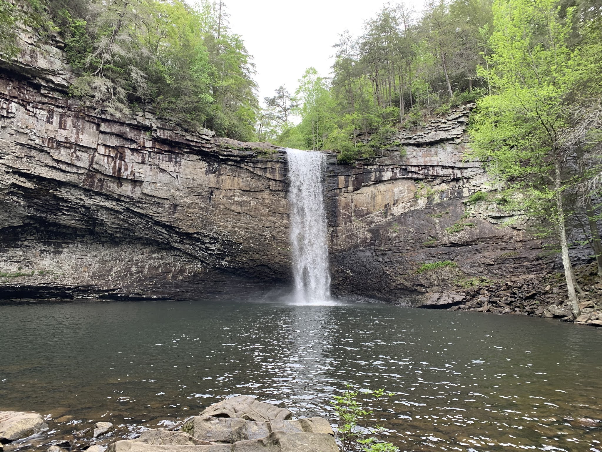
While not technically part of our planned trail, I offer the option for us to hike down to Foster Falls just below us, which is a spectacular waterfall and in my opinion, well worth the trip down. Everyone enthusiastically agrees. With our full packs on our back, we make our way down the rock hillside and across the wooden suspension bridge to the bottom of the waterfall, which drops some sixty feet over the side of a cliff into a large pool. I've visited before, but the others are in awe, as their first time seeing this masterpiece of nature. It certainly is a great way to start the trip and only added a mile or so to our our overall hike.


Heading back up the steps and rocky hillside, we begin the actual Fiery Gizzard trail, which starts out relatively tame as it meanders through the springtime wood and follows closely the cliff side, where climbers are doing their thing below us. There are a few spots one can stick their head out through the trees and take in the vista of the great green canyon below us. It spans many miles.

Before too long, we reach the first and worst of our dips into the canyon as we cross the Laurel Branch of Big Fiery Gizzard Creek. This section forces us to descend a very steep downhill across a boulder field strewn with loose soil. The proposition of this is made many times more challenging by the fact that our packs move our center of gravity slightly behind where we are used to having it. The four of us very carefully and slowly make our way over the rocks and down the hillside to the creek crossing. Here at the small wooden bridge, we encounter a young woman crossing the bridge in the opposite direction, carrying what appears to be a backpack and front pack which combined, probably outweigh her. At the bottom of her backpack, a large (probably four-person) tent hangs. As we warn her of the difficult climb she has ahead of her on this side of the creek, she sighs in exhaustion. She's obviously very fatigued from climbing down the far side and we encourage her to take a break before starting up what we have just come down. She sits on a rock and rests for a bit, while we cross the bridge and begin the ascent up the opposite side. 


This side seems to be even more treacherous as the hillside is nothing more than the fallen and crumbled rocks of the cliff above us. Every rock I step on seems to be unstable and with a fair distance between us and the creek below, I'm weary of someone falling and injuring themselves. Though very challenging, the trail is well marked here as just about every tree along our path has a white blaze attached to it and little doubt is left for the route we need to take. As we take a switchback around a large boulder, the next obstacle on this becomes clear. The trail curls around the hillside and up a step set of roots. A climbers rope has been tied along some trees hanging off of the cliff to provide a hand hold, and with a potential fall of more than fifty feet here to the rocks below, it's probably a good thing. Now reach up to grab the rope is a completely different problem and I'm forced to stretch and somewhat trust these roots to hold me as I reach for the rope. It's slack, but seems well tied and I give it a little bit of my weight as I maneuver myself and my pack around this trapeze-type obstacle course. Reaching the top, I quickly sigh in relief and they assist the others with their final steps. Everyone makes it safely, but this truly was a treacherous section.

Now on top of the plateau, we have easy trails for the next couple of miles as we cross over to the cliffs above Big Fiery Gizzard Creek. A number of small feeder creeks cut through the area, but in most cases, small wooden bridges allow us to pass over them unmolested. When we reach the McAlloyd Branch, I note a dotted line representing our trail that appears to cut around the top of that small canyon and avoid the steep descent and ascent. I suggest this route to the others and we agree to try it, heavily prompted by the danger of our last drip into one of these side canyons. 

Unfortunately, the trail represented by the dotted line either no longer exists or never did. Either way, we are left doing a little bushwhacking through the woods and later through a thorny meadow. I warn the group to be watch for for snakes as we pass near a small pond and later suggest that we do a tick check of each other to ensure none of the little bastards got onto us from the tall grasses. It takes a bit, but after crossing a boulder field covered in poison ivy, we rejoin the trail. We were confident in where we were and where we needed to go and so, we were never lost, but it just took us a while to find the trail again. 

Just a bit further and we reach the junction with the Ravens Point spur, which we've planned to take our lunch at. Due to the very rocky terrain and our caution traversing it, we are a bit behind scheduled, but I think we could all benefit from a short break to refuel. Not to mention, the view from Ravens Point is suppose to be one of the best along the route.

It's about a half-mile detour each way, but a short while after the fork, we step out onto a nearly bare rocky overlook. The green canyon that is the Fiery Gizzard flows out in front of us as far as the eye can see. It's absolutely stunning and a great place to get some lunch and just reflect on how amazing it is to be out here. After about 20 minutes and taking advantage of the facili-trees, we head back to the main trail. 

At this point, we have another couple of small creek crossings each punctuated by a beautiful waterfall. The first of which is steep embankment with a secondary cascade dropping fifty or more feet below us after sliding off of a slimy outcrop of rock. To get around this, the trail has been routed at the very top of the canyon and passes behind and under the waterfall. A sturdy chain has been been attached to the rocky face and provides a hand hold as each of makes our way under the cold flowing water in turn. While a few drops might have hit us, we remain mostly dry as the water descends a couple of feet further out than where the trail passes. It's actually a really, really cool part of this trip and a highlight for all of us.


The next small waterfall drops about fifteen feet over a small cliff and has carved out a rather substantial cave behind it. This one however has fairly shallow exit for the water exiting the large pool below the waterfall and we are able to easily rock hop across it to the other side. Just before arriving at this waterfall I had remembered and mentioned to the others to be on the lookout for abandoned moonshine stills, which I had read about when preparing for the trip. Not twenty yards from the waterfall, we find just that. I expected to find them near water, but I wasn't sure it was this particular creek and waterfall that was formerly home to bootleggers. Two large boiling pots (or possibly the two halves of a single pot) sit just off the trail rusting into oblivion. I'm sure they made many batches of moonshine in the days past, but now they just provide a reminder of the history of this region.

A little further on and we being our final descent into the main canyon. This one is again pretty steep, but not nearly as treacherous as our earlier one at the Laurel Branch. Amazing rock formations jut up from the ground, or more accurately, remain after the ground has been carved away from them by eons of erosion. We note again that the time is slipping away from us due to the very rugged nature of the terrain and how slow we are forced to travel across it. I had anticipated this hike taking about six hours, but it's looking more like either or nine a this point. All of us are very fit hikers and capable of maintaining three to four miles per hour on good trails, but the nature of this surface, the repeated dips and rises, the instability of the rocks and soil beneath our feet all force us to a snails crawl over some sections.

After reaching the bottom of the canyon, we will follow Big Fiery Gizzard Creek for the next three or so miles, again having to drop down and climb back up short little pieces where the banks have washed out. It's truly beautiful country, some of the most breathtaking I've ever seen anywhere, but it's a hard hike.

Eventually reaching the bridge that we knew has been washed out last year, we begin combing the bank of the creek looking for the best place to cross. As we search for our best option, we find the pylons of an earlier bridge, which has also been destroyed. Just before leaving my house, I had reviewed another video of some hikers on this trip only a month ago and they found a sturdy log to cross on. That too has been washed away by the spring rains. The water is not deep, but the rocks in the creek bed are slimy and dangerous to cross on. Finally, I pick a spot begin rock hopping across, relying heavily on my trekking poles to take my weight as I'm much more confident in their ability to not slip on these rocks. I manage to get across with only partially submerging my right foot. The others follow roughly in my footsteps, but as the final two seem to be having major difficulties, I recommend just going all in. Much better to have wet feet and shoes than a busted cranium. I can just imagine one of them slipping on a moss-covered submerged rock and falling headfirst into one of these stones. They take my advice and soon we are all on the other side.

Deep in this canyon, the sun is starting to near the horizon and we know we need to make this final ascent in a timely manner, else we will be setting up our tents in the dark. The trail curls around and for the most part, gently climbs this last cliff side before reaching the top and civilization. A large parking area, complete with restrooms lay before us and we take advantage of it to rinse ourselves off. The humidity in the canyon was dreadful and any chance to clean up a bit was welcome. That said, the mosquitoes take note of a slightly cleaner me just as I walk out and immediately begin feasting on me. I brush them off and quickly spray myself down with a healthy dose of repellent.

Now the task is to find the campground. Luckily a sign directs in the correct direction. It's getting dark and our pace shows some urgency, but the mile markers seem to be off a bit and what is listed as 0.6 miles feels mile like 1.6 miles. Finally, we reach our campsites and quickly set up our tents. Mine goes up very quickly and I'm the first to begin fixing dinner. We had discussed getting a campfire going, but at this late hour and with everyone completely exhausted, we decide against it. Everyone in turn finalizes their sleeping arrangements and joins me around the fire-less fire pit as we each cook our respective meals. For me, it's pad thai, which I had forgotten included a number of additional add ins within the the pouch. Most dehydrated backpacker meals simply require one to add boiling water and wait a few minutes. This particular recipe also requires me to add peanut butter, chopped peanuts, lime zest powder, and cayenne pepper at various points along the waiting process. It pays off though and is quite delicious.


Before too long, we're all ready to crawl into our tents and get a good night's sleep. While the trail was listed as 12.5 miles each way, the addition of Foster Falls, Ravens Point, our campground, and our detour around that one canyon bring my total to 19 miles for the day. I also think the trail listing was a bit off, as everyone else's GPS tracks also show significantly more distance. All good though, we're here now and almost as soon as I crawl under my quilt, I drift off to neverland. 

I only wake a couple of times through the night. The temperature was perfect for camping, only dropping into the mid-fifties overnight. At some point shortly before sunrise, I hear a rooster announcing the incoming new day, but I roll over and fall back asleep. Finally waking up around 6:15 AM, I check the weather report. I know there is a storm coming, but I was hopeful we could beat it out. That said, I'm very reluctant to do some of those rocky and treacherous climbs in the rain or shortly after a rain. The slickness of the wet rocks would make the trip exponentially more dangerous.


I crawl out of my tent and begin fixing my favorite backcountry breakfast, granola with milk and blueberries along with a cup of hot lady grey tea. As the others emerge, I explain the situation with the storm and propose that we attempt to find a ride back to our cars. Everyone wholeheartedly agrees. As we have a few hours before the storm arrives, we take our time breaking down our camp, but once we have done so, we hike back out to the parking lot and begin looking at our options. Uber is a possibility, but it takes a bit for us to find a driver. Eventually, we find a note on the back of the informational board that advertises a shuttle service. This would be ideal as we could load ourselves and our packs into the shuttle instead of having to send one person back for a car and then that person coming back to pick up the rest of us and our gear. We make the call and a few minutes later our friendly shuttle driver arrives. I hate that we won't get to hike back today. It would have been an outstanding return trip, but I just feel that it would be too dangerous with the incoming weather. We made the right decision.

Returning to our cars, we agree to stop in Chattanooga for a beer and some lunch. Meeting at Chattanooga Brewery, we enjoy the last hour of each other's company over some tasty beverages and some outstanding brunch selections. Everyone agrees that this was one of their all time favorite hikes and laments how difficult it truly was. We further agree that while it would have been nice to do the return trip today, using the shuttle service to avoid the storm made good sense and we were glad we made that decision. As for me, I'm heading home now. While I don't know that I will ever do this trip again, as there are so many other trails I want to hike, I would highly recommend this one to anyone, but be warned, it is challenging!

Sunday, May 2, 2021

Georgia Renaissance Festival (Fulton County, Georgia)


As vaccinations to COVID-19 are becoming more and more available, the world is beginning to reopen. I haven't been to a Ren Faire in a couple of years. In fact, I don't think any have been held since the pandemic began over a year ago. That said though, the Georgia Renaissance Festival, just southwest of the city, is opening this weekend and I thought it might be a good opportunity to spend some time with my mother and expose her to something new.

I really had no idea of the scale of this particular Ren Faire, but judging by the large grassy parking area and the number of cars already there when we arrive, I expect it is going to be fairly substantial. As we enter, I can see that I was correct. The structures appear to be permanent, meaning that they are not taken down each season after the end of the faire, but remain for reuse year after year.

We first make our way over to the raptor demonstration, as a master falconer, demonstrates the hunting techniques of his trade. Following that, we walk around a bit more while Mom enjoys the shops and wares of the visiting merchants. We arrive at the jousting arena just at the end of the performance, but while I wander off to hit the ATM, Mom gets to see the final couple of pairings. After that we grab some lunch and walk around a bit more. I think she is taken with the costumes and general culture. While our stay is relatively short, as she's already had quite a busy day, I think she really enjoyed seeing something new and more than anything, just being out among people again.

Rottenwood Creek (Fulton County, Georgia)


When time allows, I try to take my elderly mother out for some exercise on the trails. One that has been catching my interest for the past few weeks is the Rottenwood Trail, which starts at the West Palisades parking area and after following the Chattahoochee River for a short distance, takes a left and continues up a paved trail alongside Rottenwood Creek. It seemed a great place to take her and since I will be out of town next weekend, I thought I would let today serve as something of a Mother's Day present. After getting in some big miles yesterday, I'm content with hiking at a much slower pace and along some paved trails today.

The weather is absolutely perfect and though it sprinkled on us a little bit on the drive to the trailhead, we encounter no further rain once we leave the jeep. The trail is popular and we pass many other hikers and bikers out for their daily walk or ride. Mom comments on how pretty the river is as she notes some Canadian geese out flapping in the shallow waters. Our route is nearly flat and with the pavement, she has very little difficulty. Once we make the turn to head up the creek, she seems to enjoy the views of the small stream. It is actually quite pretty. After a little over a mile, we decide to turn back, but that still ends up giving us about 2.3 miles, which is a really good distance for her.

Saturday, May 1, 2021

Wagon Train Trail to Brasstown Bald (Towns County, Georgia)


Continuing my preparation for an upcoming Grand Canyon backpacking trip, I decided to post an event to hike up the Wagon Train Trail to Brasstown Bald on the Meetup site. This road and/or trail was built in the 1950's by convict labor and used by locals to travel the seven or so miles from the community of Young Harris to the summit of Brasstown Bald, the tallest peak in the state of Georgia. At the summit, these families would camp and socialize while taking in the magnificent views.

When I arrived at the trailhead, there were already five of the hikers that had signed up there and ready to go. I always try to be early for events that I'm leading and these folks decided to arrive even earlier. I do appreciate their punctuality though. At 10:00 AM, the listed start time, we do a quick round of introductions and I provide an overview of what the group will be in for today. One of the hikers has hiked this trail twice previously, which is twice more than I have, though I have researched it in preparation for today's trip. Still, it's always nice to have someone along that knows the trail when I don't. And with that out of the way, the six of us immediately start our hike.

Leaving the parking lot of Sharp Memorial Church, we walk a short way up the road and then climb a number of steps to a parking lot owned by Young Harris College. At the far side, we can see the red gate, which marks the beginning of the trail. The first couple of miles are double-track and likely where the name comes from, but before too long, the trail becomes single track as it gradually climbs the side of the ridge. 


The views are somewhat obscured here by the spring foliage, but a couple of clearings offer up some outstanding vistas, including one that allows us to see Wolfpen Ridge, which we are currently climbing toward, as it curls around to the summit of Brasstown Bald and the observation tower on top of it. It's an extraordinary view.

The entire way, I've been pushing the pace pretty hard. I had listed this as a 2.5 mph hike and reminded everyone with me that we would be trying to maintain that pace throughout. The entire group seems to be doing pretty well and no one falls significantly behind. It is an arduous climb though and doesn't seem to relent much at all. 


Finally reaching the intersection with the paved summit trail, we begin the steep and popular part of the trail, which will take us to the observation deck. My past two visits to Brasstown Bald have been overcast and the views were hidden by cloud, but today, the skies are clear and the sun is beaming golden rays down on top of us. It should be terrific. Now, we just have to climb to the top up this extremely steep walkway that extends about a half-a-mile from the parking lot to the summit. Luckily, our trail intersects part way up and we have a slightly shorter distance to climb, though we had to hike seven miles to get to that point.

Once we reach the top, I tell the group to take a few minutes to enjoy the view and get a snack. I suggest that we'll reconvene in a grass area that I point to at about 1:15, before heading back to our starting point. Everyone agrees and disperses to do their own thing. There are a lot of other visitors here at the observation tower (of course, the vast majority simply walked the half-a-mile from the parking lot), but not nearly as many as I was expecting on such a gorgeous day. I take a few minutes to walk around the tower ring and get some pictures. The views are as breathtaking as I had hoped they would be. In all directions the green canopy of southern Appalachia spreads out before me. As we are still in spring, some of the trees toward the tops of the nearby peaks have yet to gain their full green foliage and remain in various shades of beige and brown. This gives the landscape a sort of rainbow appearance as the bright greens of the lower elevations around us transition to the darker and browner summits. It's truly spectacular.


At the appointed time, we gather back up and having consumed a few calories in the form of bars or fruit, we all feel ready for the long descent. The return trip will be slightly quicker as downhill always is. As we make our way back to the trailhead, we chat about various topics and simply enjoy each others company and our accomplishment.

After a total of 15.1 miles and approximately, 3,000 feet of elevation gain and loss, we finally return to our cars. The group thanks me for organizing and leading and I thank them for joining me. I was really impressed with this group in that they were all able to keep up the listed pace and we finished the hike just a few minutes before the planned 4:00 PM end time. I believe everyone enjoyed the hike and I hope to seem them again on future trails.