Sunday, May 29, 2016

Broken Arch (Arches National Park, Utah)


After taking a couple of hours rest during the hottest part of the day, I decided to do another hike in Arches National Park. Directly across from my campsite, was a trail head listed as Broken Arch and offering distances to three other arches on interconnected trails. I've already logged over thirteen miles for the day, but . . . why not?


The trail to the first of the arches, Tapestry Arch, requires a fair amount of rock climbing, but is completely worth it. Even beyond the arch itself, I find a way to delicately reach the top of the Mesa. And who would have thought, but out here in the middle of the desert, I get a strong cell phone signal, unlike just about everywhere else in the park. I take a few minutes to catch up on texts and emails, before ascending to the top for one of the most spectacular views I have seen. I can see for miles in all directions. And everywhere I look, I see arches and sandstone pillars. Truly amazing.


Heading for the next Arch, I stop to take a few shots of a gigantic column just out here on its own in the desert. The majesty of this place is a tangible thing.


The remaining two arches on the hike, the namesake Broken Arch and Sand Dune arch are not nearly impressive as what has come before. I'm not even sure about their names, but the landscape itself is fantastic.


After departing Sand Dune arch, I decide to head back to camp, but noticing that I have over 40k steps for the day on my Fit Bit app, I decide to take a nice stroll back to the Devil's Garden trail head to knock out the 50k badge. While this final hike for the day was only about 2.5 miles, I walked and hiked a total of nearly 22 miles today. Not bad at all.


Devil's Garden (Arches National Park, Utah)


One hike down and a couple of more to go before I call it a day. After heading back to camp and enjoying a light breakfast, I head for my second hike of the day, Devil's Garden, which is at the extreme northern end of Arches National Park. Luckily, my campsite is only about three-quarters of a mile from the trail head and I decide to simply walk the distance.

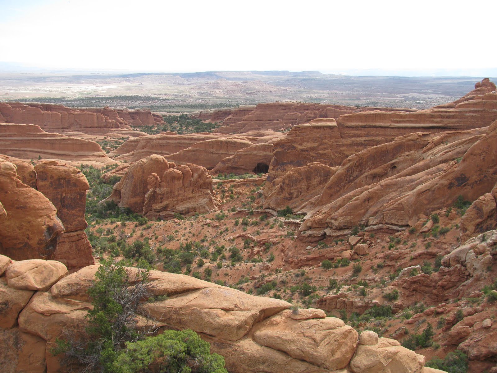
The Devils' Garden is very appropriately named. The blazing sun will bring temperatures in this area into the low 90's, and along with the reddish-orange color of the sand, stone and general landscape, one is reminded of hell. That said, it is truly one of the most beautiful places I have ever seen, filled with amazing sandstone arches, pillars, cliffs, crevasses, etc. As I peer into the initial canyon at the start of the trail, I'm excited to see what all this hike will have to offer. 


The trail itself is generally a loop, but has a large number of connected side-trails, each leading to a specific arch or other feature. This must be one of the most dense samples of sandstone arches in the world, probably why the park is named as such. The first arch I visit is Tunnel Arch, looming large over the small valley it sits in.


Next on the list and just a short distance away is Pine Arch, which unlike its neighbor, sits at ground level and allows visitors to walk underneath on a floor of red sand. Many admirers take time to snap a few shots of their friends and loved ones under the arch, but are courteous enough to not linger more than a few moments to allow everyone to get a turn.

Continuing a bit further and to the end of the maintained trail, I arrive at the area below Landscape Arch, which boasts the longest span of any of the multitudes of arches in the park. It is quite breathtaking, but the trail only gives a view from a distance, which is probably a good thing. I can imagine the masses trying to climb on the thin arch and destroying its magnificence for all time.

From there, the trail is listed as 'primitive', meaning there will be lots of sand to a walk and a large amount of rock scrambling. While I dislike hiking on sand, I do love rock climbing. The first test comes up almost immediately as I must scramble 150 yards or so up a sandstone sheet sitting at an approximate 40 degree incline. I pass a couple of other hikers as they stop to catch their breath, and while the scramble is a little challenging, I feel like I'm in very good shape at the moment, especially as I reach the top without stopping and only breathing slightly harder than normal.


I next visit Navajo Arch and Partition Arch, both of which offer their own unique example of what sandstone arches can be, and of course offering and even requiring some climbing opportunities along the way. I do love climbing around desert landscape, though I'm very careful to only climb over durable surfaces and certainly not on top of or even near any of the iconic arches along the trail.


After another mile or so, I arrive in a shallow little valley looking up into the Double O arches. The smaller one must be passed through to get to the other side and to see the larger of the two above. This area offers one of the best opportunities to climb and explore so far, as the cliff is steep by passable and allows access to the large red ridge leading out and acting as the cap to the larger of the Double O arches. I make my way up, but conscientiously avoid getting close to the arch itself. The views from up here are truly awesome - and I use that word for its true definition, not the modern over use.


One final stop before heading back to camp, the Dark Angel. I had read about and seen pictures of this feature in the past, but being only a half mile or so from it, I couldn't resist. The trail leads down from the Double O arches and further out into the extreme north-western part of the park. Even from this distance, the pillar of darkened sandstone known as Dark Angel is visible, standing off on its own away from other cliffs. The trail to get to the feature is unremarkable, except for the views, which I've already commented on. Arriving at the base of the pillar, I am surprised to see rock-climbers three-quarters of the way up the back side of the column. I'm pretty sure they are not suppose to be climbing here.


With most of the noteworthy features explored, I turn to head back down the backside of the primitive trail loop, but before I get to far, I remember another arch, Private Arch, which is on this backside. Of course, I have to visit that one as well. From that point on though, the trail gets a bit more dangerous and requires careful maneuvering over slick sandstone cliffs and along narrow passage ways. I help a few other hikers ascend and descend over some of the ridges, but its getting very, very hot and its time for me to head back. 

Including my distance to and from my campsite, this trail clocks in at just over 10 miles. Not a bad start to the day and definitely a trail worth visiting for the site-seeing. 

Delicate Arch (Arches National Park, Utah)


I arrived at Arches National Park, my primary destination for Memorial Day weekend, late yesterday afternoon, but there was a long line to get into the park. Instead of waiting in line, I decided to head into the nearby town of Moab, UT and check out the local brewpub. The beer was cold and they had a couple of brews that weren't bad, but more importantly it delayed me enough to get back to the park just as the lines were dying out. I set up camp and crashed for the evening after a long drive.

Awaking early as I normally do when tent camping or backpacking, I decided to head up to the iconic Delicate Arch to see the sunrise. This most famous of arches is the symbol of Arches National Park and of the state of Utah itself, even appear on the state's license plates.

As I arrived at the trail head parking lot, I was glad to see that only a couple of other cars were there. I headed out in the pre-dawn light thinking that I wouldn't need to compete with the crowds so badly this early. My hunch turned out to be correct. The trail winds around a preserved cabin and corral from one of the early settlers of the area, before heading into the sandstone desert. Twisting and turning through the rolling desert hills, I finally reach a mountainous sloped piece of red sandstone. Specifically placed cairns indicate the trail leads up this slope and beyond. The uphill is a little rough, but I wanted to get some good exercise today anyway.


Continuing to struggle slightly to stay on the trail, as it is easy to loose in this landscape, I eventually reach a sign indicating the proper direction to the base of the arch. The trail now skirts alongside red cliffs, as the sun begins to come up over the horizon. Then finally, I see it - the might Delicate Arch. The feature stands about 70-feet tall and has the general shape of a the lower half a ancient samurai in the hanmi stance, ready to strike.

There are few others here relaxing on the curved sandstone cliff just above and behind the arch. Everyone is admiring the first rays of the morning sun as they bring Delicate Arch to its full color potential. The reds and oranges are amazing.


After a short time taking in all this spectacle, I decide to head back for the trail head, but not before taking a very short side trail to see a petroglyph panel created by the Ute Nation somewhere between 350 and 150 years ago. Luckily, the panel has been well preserved and the carelessness of the modern hasn't made left any marks on the preserved artwork. In total, the hike was only about 3.2 miles, but it was the first of several I would do today.


Saturday, May 28, 2016

Goblin Valley (Emery County, Utah)


Southern Utah is without a doubt one of the most spectacular geological regions on the face of the planet. With numerous national and state parks, one could spend decades exploring and still not see it all. I had gotten camping reservations several months ago for this, the Memorial Day weekend, in Arches National Park and Friday afternoon, set out on my long drive from Reno. Though, I'm rarely one to stick with a single destination when there are so many options. A couple of years ago, I read a story of a couple of 'outdoor enthusiasts' maliciously destroying some of the incredibly geology at Goblin Valley State Park (I hope they were heavily fined AND incarcerated, if not just simply beaten), which until that point I had never heard of, but the story put the park on my radar. As it turns out, the park is only about an hours drive from Arches and I decided to take advantage of the proximity to visit the site.

The drive to the park follows some paved roads through the Utah desert south of I-70, but covers some truly beautiful expanses of land. Arriving at the park entrance, I noted the large number of RV's and tents that had set up camp outside of, but around the park. I suppose its hard to get reservations and the land here is not fertile enough to do much else with it. I can see why people would go this route. Entering the park, I get a map from the ranger and make way to the primary crowd draw.


Parking spots at the trail head is abundant, but on this holiday weekend, empty ones were few and far between. A ranger directing traffic suggested my pulling the jeep just off of the side of the road on the hill approaching the parking lot and then walk up to the trail head. I followed his advice, which offered a great opportunity to snap some pictures of the 'Three Sisters' formation, which is separated from the rest of the land features by a couple of hundred yards, but is one of the more iconic images from the park.

Arriving at the trail head, I'm somewhat in awe of all of the people. A covered picnic table area is packed elbow to elbow with families. No thank you - I'm here to enjoy the outdoors and so, I begin descending down into the valley itself to see the mushroom-shaped rock pinnacles known as hoodoos, or more commonly in this park, as 'goblins'. Thousands of these slightly larger than human-sized structures carpet the ground and come in a variety of shapes, most vaguely resembling mushrooms. The dried mud and sandstone has been carved away by erosion to leave these incredibly interesting features.


In addition to being in awe of the landscape before me, I also find myself getting irritated by the carelessness with which many of the visitors climb on and around the delicate structures. I truly wish people would consider how their actions may affect the world around them.

I continue exploring a bit, but there really isn't much of a trail to be found, just pathways between the dense hoodoos. After walking around for a short time, I decide to call it quits and head back to the jeep. I still have to get to Arches, check in and get my camp set up before sundown. I hope Goblin Valley is around long enough for you to visit it, but with the lack of concern people show for the interesting landscape, I'm not sure it will be.


Sunday, May 22, 2016

PlanetWalk at the Robert Ferguson Observatory (Sonoma and Napa Counties, California)


Can one walk to Pluto? Today, I'm going to try. Last month, I was able to take part in a magnificent class on the geology and terroir of the Oakville AVA in Napa Valley. I had fully intended to do this hike at the finish of the class, but timing and weather were not with me that day and so, I had to skip it. However, since I was in the general area and ahead of schedule today, I figured I would knock it off of my backlog. Driving up from Mt. Diablo State Park where I had camped the night previously, I made it to Sugarloaf Ridge State Park, which houses both the Robert Ferguson Observatory and the PlanetWalk by 11 am. I took a few minutes at one of the nearby picnic tables to eat the light lunch I had packed before hitting the trail.

The trail starts near the observatory with a sign symbolizing the sun. One of the interesting things about this hike, is that the planet placards are spaced at distances relative to each other and on a scale that both makes for a good hike and allows the smallest of our solar system's planets to be at a visible scale (1:2.36 Billion), though Mercury and Pluto are not much more grains of sand. 


As you might imagine with any grade school level of astronomical distances, Mercury, Venus, and Earth are all very near the observatory. In fact, the placard for Earth is affixed to the building. To get to Mars requires just a few steps down the nearby Meadow Trail. 

Leaving the inner solar system and heading towards the gas giants OR on this scale, opening up into a grassy meadow with some beautiful mountainous hills above, Jupiter is quickly encountered a bit further down the trail. Further still is Saturn, laying in the tree-covered canopy of a creek bed. The walk is pleasant and cool, with the calming sound of the water flowing over the small rocks and falls of the creek bed. Crossing a sturdy wooden bridge and turning onto the Brushy Peak Trail, as directed by the sign, I soon encounter Uranus.


The sign warns that Neptune and Pluto beyond are much further down the trail and that it will start climbing steeply. I came for a workout though and walk the distance between the Sun and Pluto seems like a good way to make my steps for the day (or the steps for the entire human race). They were quite serious about the uphill, as a number of switchbacks take me deeper into the woods and towards the summit of Brushy Peak. I push my pace as I want the exercise value of this hike. Finally, reaching the sign for Neptune, I observe the weather and note a possible storm cloud rolling in. Another near mile to Pluto, but I don't know when I will be back over this way again and I do have a poncho with me. I push on towards the Kuiper Belt and the demoted planet at the edge of our solar system. The climb is extremely steep in places, but I eventually reach my destination. I note that at this scale, Pluto would be about the size of a grain of sand.


Seeing the planets and the distance between them at this scale is really eye-opening. My round-trip distance was almost exactly 5-miles and afforded me a pretty good workout (especially, since this was my second hike of the day). It's great to see educators and scientists building/designing things like the PlanetWalk, especially for the younger audience. I applaud their efforts.

Mount Diablo Summit (Contra Costa County, California)


For a while and in addition to the backpacking trips on my calendar, I have been putting together several 'car camping' trips for this year and a trip to Mount Diablo State Park near San Francisco Bay was the first to come up on the calendar. The drive over on Saturday afternoon was uneventful, though it was a bit gloomy and with fresh snow over Donner Pass, I was a little concerned at how dry the trip would be. It turned out okay though and I arrived at the park by about 4 pm. The signage entering the park is a bit confusing. My site reservation simply listed the site name as "JU Standard Site". The first campground I past was called Junction Campground. The campsites here were completely vacant, but served my purposes and so I picked one and started setting up camp. A short time later a ranger came by and corrected me. My reservation was actually for Juniper Campsite . . . both start with JU . . . how could I know, lol. Anyway, he was fine with my staying here and so I continued with my campsite preparations. 

The evening got a little chilly, but after a quick dinner hoping into my warm sleeping bag quickly fixed that issue. The night was quiet (with no one else nearby) and I slept pretty well, though I woke bright and early at about 4:30 am. I crawled out of my bag and put on some fresh clothes. Surprisingly, my tent held the warmth pretty well and it wasn't all that cold until I zipped open the rain cover. Almost immediately as I started preparing some breakfast, I heard some rustling in the nearby bushes. I went over to investigate and met a curious (and probably hungry) raccoon. He seemed very calm around me, indicating that he was a regular visitor to the campsite. I gave him a little gesture and yell, and he was off back into the woods, allowing me to continue making breakfast and breaking camp.


I was on the trail by 6:30 am, but the fog was so dense, I could barely see. It made for a pretty cool hike. I did have a few rain drops fall on me, but my recent visit to Tennessee, numbed me to that little concern. It never amounted to any significant rain. The trail itself twists and turns through the yellowish-gold hillsides spotted with the occasional green island fashioned from small trees above the grasses. 


The area of these hillsides was obviously burned recently, as there were charred reminders of that everywhere, but the vegetation is coming back strong. The trail heads pretty relentless uphill towards an unseen mountain top, thanks to the dense fog. Finally, though I reach the parking lot at the top of the mountain and see the beautiful antique stone building housing a large spotlight. Reading a bronze panel, I see that he 'light house' was used to ward plans away from the mountain prior to WWII, but was discontinued at that time so as not to direct the Japanese to the mainland. Exploring the attached observation deck, I'm thrilled with the view. The clouds and fog are below the summit, which makes for some breathtaking scenery at this time of morning. Though, I cannot see as far as others have reported due to the cover layer, the angelic nature of cloud-covered landscape more than makes up for it.


Turning to head back down the mountain, I encounter a few more hikers making their way to the top. Shortly thereafter, I reach the jeep and head for my next destination. All in all, the hike was only about 4.6 miles, but the scenery was outstanding.

Thursday, May 12, 2016

Bassi Falls (El Dorado County, California)


I had intended to do this short hike a about a month ago while in El Dorado County for the annual Passport Wine Event, but the weather was not cooperative. However, I had read that the falls are spectacular in late April and Early May, while dwindling down to nearly nothing by the end of spring. I wanted to see the falls at its full glory and so, I arranged my work week in such a way to allow me to scoot out of the office a little early today. It's about a 2.5 hour drive from Reno and so, I needed all the time I could get.

Driving through South Lake Tahoe, I could clearly see there was still quite a bit of snow at the higher elevations, which of course made for some spectacular sheets of water rolling off the road-side granite, but also gave me a bit of concern about how accessible Bassi Falls would be. I wasn't deterred though and hit junction of Highway 50 and Ice House Road at about 4:30pm. The drive into the forest on this road is about 15 miles, with winding curves and spectacular views galore. Finally, crossing Big Silver Creek, I took a quick right onto Forest Service road 12N32A. After just a couple of hundred yards, I was happy to see the gate had been unlocked. When I attempted this hike a month ago, the road was closed. I had contacted the Forest Service and they confirmed that it would be opened when conditions allowed passage, but couldn't give me a date at that time. Having the rough dirt road accessible trimmed about 3 miles off of the total hike distance, which normally wouldn't be anything to be excited about, but with darkness just a couple of hours away and a 2+ hour drive back to Reno, the quicker I can get in and out, the better.


Arriving at the Tower Rocks Trailhead, I park the jeep and head out on foot. Only one other vehicle is parked here, which gets me excited about the prospect of having the falls nearly to myself. As I get just a few yards down the trail, I encounter two friendly women, who confirm that no one else is at the falls and that the vehicle is theirs. Woot! The trail to the falls is an old jeep road through a lush forested area, with lots of twists and turns, but the occasional tree marker and cairn make navigation fairly easy. I can hear Bassi Creek in the distance and take a couple of opportunities to get some shots of the rapids and smaller falls. 


Encountering a pretty impressive 25ft fall, I wonder if this is Bassi, but surely not. While powerful, I can't imagine this small, broad falls as a hiking destination (at least in this part of the world). I continue on and eventually encounter a knoll of slick granite with water scouring over it in nearly all paths. There are few dry sections, which I use to make my way further up and then I see it. One would have thought to hear the 109 foot Bassi Falls before seeing it, but with the smaller falls and healthy rapids flowing so near, it all becomes a symphony of granite and snow run-off. Looking up and ahead, the falls towers over me and I must climb further up this granite hillside to reach the base.

The falls is truly impressive. The power and flow of the water coming over this drop-off is truly amazing. I've seen many waterfalls in the past few years (many taller, many broader), but this is certainly one to remember. I maneuver as best I can in and around the water-sheet covered granite to get some good shots of the mighty waterfall. Luckily, I'm here completely by myself and there is no one to get into my pictures. As I get closer, the roar of the falls starts to become a distinct voice among mother nature's orchestra. 


After spending a few minutes absorbing my surroundings, I start to head back out the way I came in. While trip was little rushed and required a fair amount of driving, I feel as though it was worth it. The hike itself was just over 3 miles, but the impressive views made it a great hike.