I moved to Reno, NV in December '02. I was drawn by the beauty of the desert mountains, the quick access to Lake Tahoe, and the ease of leaving the urban-life behind anytime I wanted in exchange for the breadth of solitude available in this barren part of the world. When spring came the next year, I spent most weekends driving off in a random cardinal direction looking for new things I've never even imagined before. On one of those early weekends, I headed up through the Black Rock Desert and eventually ended up at Crater Lake in Central Oregon. On that trip, I passed a sign for the Lund Petrified Forest and while I slowed down slightly, I didn't take time to really explore. I've always regretted that decision and decided to do something about that regret today.
After returning to the highway from my off-road adventures at Pig Rock, I drove around Pyramid Lake and north up NV 447 all the way to Gerlach. From there the path, takes me along NV 34 along the western side of the Black Rock Desert, past the Fly Geyser, and then into the gravel roads of the High Rock Conservation Area.

Beyond the completely barren playa of the Black Rock, the landscape is very Nevada-esque in both the vegetation and topography. Rolling desert hills covered with sage brush are my only companions for many miles as I drive towards the Idaho Border far to the north. Along the way, I encounter a number of wild mustangs. Not surprising, as this state is home to the largest population of those living symbols of the old west. Majestic is the word that comes to mind as I stop in the middle of nowhere to say hello to some of my four-legged statesmen, but I can't help but think of how hard these gorgeous creatures must live. Consuming what little nutritious vegetation that can find in this harsh landscape. The herd I've encountered looks healthy though and I wish them well as I continue on my journey.
A few miles further, and I arrive at the sign I first saw nearly fifteen years ago. A wide spot in the road and a bronze plaque affixed to a concrete marker indicate that I have arrived at my destination. The plaque tells of George W. Lund's untiring efforts to preserve the trees of this petrified forest.
I spend a bit of time exploring the jeep, including some further off-roading up an steep hill, before deciding to park and explore further on foot. There are two basic parking areas just off the gravel highway that have enclosed amazing examples of petrified stumps within a fence barrier. However, by research indicated that a number of other specimens can be found in the hills just beyond the highway.
Hiking a short distance, I stumble across a number of them. The remains of each tree has a unique character. Many are nothing more than tree stumps, but the wicked eons have converted all of the biological material from wood to stone. The visible tree rings leave no doubt that these stones are more than just mere rocks. I can't help but wonder what this area looked like the million+ years ago when these rocks stood as living trees shading the landscape around us. What wonders this area must have held back then and oh, I what I would give to be able to visit that time.
I continue walking among the remains of the ancient forest and find a number of additional petrified specimen. Finally, I decided that it is time to head back to civilization. It is the Eve of a New Year after all, and while this ancient forest takes little notice, as it one among millions, for me, it is one among tens and I know where I want to spend it.
I'm always looking for new and interesting places to hike, explore or go wheeling (4x4 off-roading). Some time back, I read about a rock formation near Pyramid Lake that is very popular among the climber community called Pig Rock. As I had New Years Eve morning free, I thought I would take the jeep out exploring and try to find it. Watching for a notable butte about four miles from the lake and on the western side of NV 447, I find my dirt road turn-off. At first, the road is very navigable, but the spring melt has cut some deep washes into what was probably an easily navigable road last year. My big rubicon makes short work of those washes though. After about two miles and a bit of minor rock climbing over some small boulders, find myself climbing through the final deep wash before arriving at a rock formation that leaves no need for imagination. Pig Rock rises from the sagebrush as a 25-foot tall sandstone monolith. The eye, the ear, the mouth are only plainly obvious. Just beyond the pig, a sheer sandstone cliff rises 40-feet out of the desert. This is obviously the climbing destination. It was a fun drive and I'd love to do a bit of hiking in the hills surrounding me, but I have more miles to put in before the day ends.
A couple of years ago, I read of a natural arch near the top of Hinkey Summit, north of Winnemucca. For some time, I've been wanting to get up that way to check it out, but it seems every weekend during the summer and fall was pretty much packed with activity and I wasn't able to find the time. So, I decided to get up this morning and make the drive.
Heading north on US 95 out of Winnemucca, I took the right turn on to NV 290 also known as Hinkey Summit Road. The route took me through the wide upon paradise valley and the namesake town in the center of it. A few miles north of town, the pavement ended and the gravel road continued into Santa Rosa Mountains.
Using Google Earth, I thought I had located the rock face containing the arch, but as the road twisted and turned on its way to the summit, I searched every rock face in sight and couldn't see it. Finally, when I reached the top of Hinkey Summit, I spotted it. The pass is only about 7,900', but in mid-December, the weather was blizzard like, but luckily with only a couple of inches of snow on the ground.
As I found a place to park the jeep and get out, the strong winter winds sent chills through me and in just the time it took to walk the short distance to the base of the arch, it felt like me fingers and ears were going to freeze off. I had wanted to hike up around to the top of the arch, but with the freezing temperatures and more snow on the hillside, I decided I'd rather be warm in the jeep. At least I found the natural wonder.
Having spent all of last weekend traveling, I wanted to stay closer to home this weekend, but I also wanted to get some trail miles in. To be able to do both, I decided to knock Prison Hill off of my checklist. Prison Hill overlooks Carson City to the west and the Carson River Valley to the east and south. It was so named because stone was quarried from one of its outcroppings to build the state prison just below the hill. The trail I'm planning to hike today is called Escape from Prison Hill.
Arriving at Carson River Park just after 9:00 AM, I use the map I saved to my phone to try and get my bearings, but the trails scarce resemble the map. Intertwined with the foot trails along the river, some cattle trails from the nearby Silver State Ranch cover the landscape. It's difficult to know which is which, but I start following the trail closest to the river looking for the Old Mexican Dam shown on the map. In the 1860's, a ditch was cut to divert water from the river for irrigation.
After a little over a mile, I come across a dilapidated wooden gate in the water-filled ditch with a retractable floodgate. I question whether or not this is the "dam", but the distance seems off from the map and so I decide to continue a bit further. After another mile, I come to what I was looking for - a large spillway that spans the width of the small Carson River and a grated bridge over the water diverted into the ditch. I continue around the large pool collected behind the spillway and eventually reach the turn in the trail I was looking for.

The trail diverts from the river and begins a steep climb up the southern face of Prison Hill. It's double-track here, but lacks any switchbacks. A number of dirt bike trails have been cut into the desert landscape, making navigation somewhat confusing. In addition, the the lack of switchbacks up this steep incline makes for slow going. In fact, I would venture to say this is one of the steepest hills I have climbed on foot (and with all of my adventures, that is saying something).
As I reach a large junction, I try to determine the correct path, but there is no signage and again the map is of limited use. As I later discover, I should have gone the opposite way in order to get the full mileage of intended trail. Regardless, I eventually find a connector trail that returns me to the main trail, but it saved me three or so miles, which was not my intention. Given the workout I got from climbing up here, I'm not entirely disappointed.
Reaching the highest point on the trail, I can see Carson City below me and in the distance I hear the "choo-choo" sound of the Carson-Virginia City Rail, apparently giving one of its frequent nostalgic tours.
From here, I continue a bit further and then decide to drop back down into the canyon known as Dead Truck Canyon. The trail is pretty well maintained and as I reach the approximate midpoint, I discover how the canyon was named. An old truck is half buried in the wash of the canyon. It appears to have been for fifty years or more and the rains have washed soil, boulders, and brush over the bed and partially into the cab of the truck. Getting such a vehicle up here is must have been quite a feet, as the canyon and all the hillsides leading to it are very steep. I suspect my jeep could have made it, but not easily. This truck was far from an off road vehicle in it's heyday. Regardless, it apparently died here and thus gave the canyon its name.
As I move further down the canyon on my way back towards the park where I left my jeep, the trail diverts to the sough from the wash, and later I see why. The wash gets much, much steeper. The truck wouldn't have had a prayer of making out this way.
Eventually, I reach the ranch and cross an actively grazed field. The cows on either side of the trail glance at me curiously, but are content to relax in the warm December sun. Arriving back at the jeep, I check my distance. I only covered about 6.8 miles, which is far short of the 12.7, I had intended to cover. Nonetheless, the steep hills made for a great workout.
For many years, I have had a great interest in the indigenous rock art of the Americas. Perhaps, it comes from growing up in and around the legend of the Piasa Bird, or maybe it's just the parallels I see between the artists wanting to leave a mark on the centuries and my own desire to leave a legacy. Whatever the genesis might be, I recently learned of a Rock Art 101 class being taught by a number of anthropologists from the California Rock Art Foundation. The syllabus included a number of lectures on Saturday followed on Sunday by a rare tour of some of the most dense and artistic rock art of the Coso Range, which is mostly contained within the boundaries of China Lake Naval Air Weapons Station. Of course, I had to jump on this amazing opportunity.
Leaving work on Friday afternoon, I made the six-hour drive to Ridgecrest, CA and got checked into my hotel. The next morning, I awoke early and drove the short distance to the Best Western where the lectures were to be held. During the course of the day, we learned about a number of rock art-related topics, including methods for dating, stylistic differences, the history of the peoples of the Coso Range, determining gender of rock art figures, and finally, an overview of the rock art of the La Rumorosa. The speakers were amazing as they share years of research and their collective insight into the topics covered.
On Sunday, we met near the base before going through a vehicle inspection by the military police (we had previously provided information to facilitate formal background checks) and some rules for our tour, before caravaning the 40-ish miles out into the desert of the dry lake bed of China Lake to Renegade Canyon, also known as Little Petroglyph Canyon.
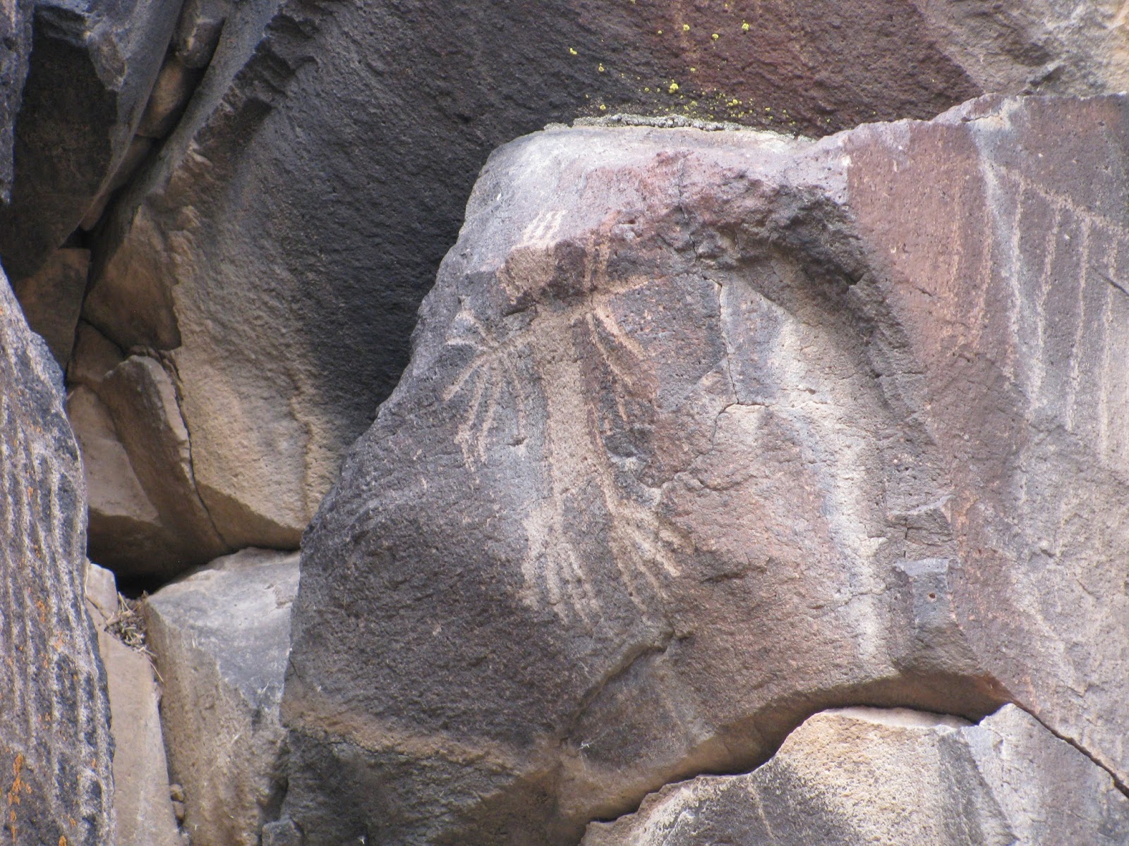
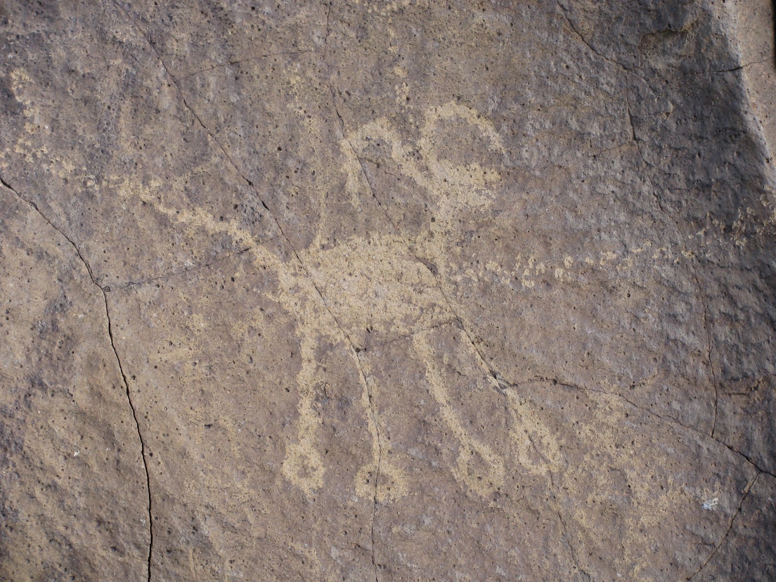
As our group of about twelve rock art enthusiasts and amateur and professional anthropologists followed our Navy-cleared guides, we were amazed at what were seeing. The canyon itself is only sinks a few feet below the desert floor and winds a length of perhaps three or so miles, but the density of rock art (mostly petroglyphs) is unbelievable. It was difficult to find a surface that had not been turned into an ancient art piece.
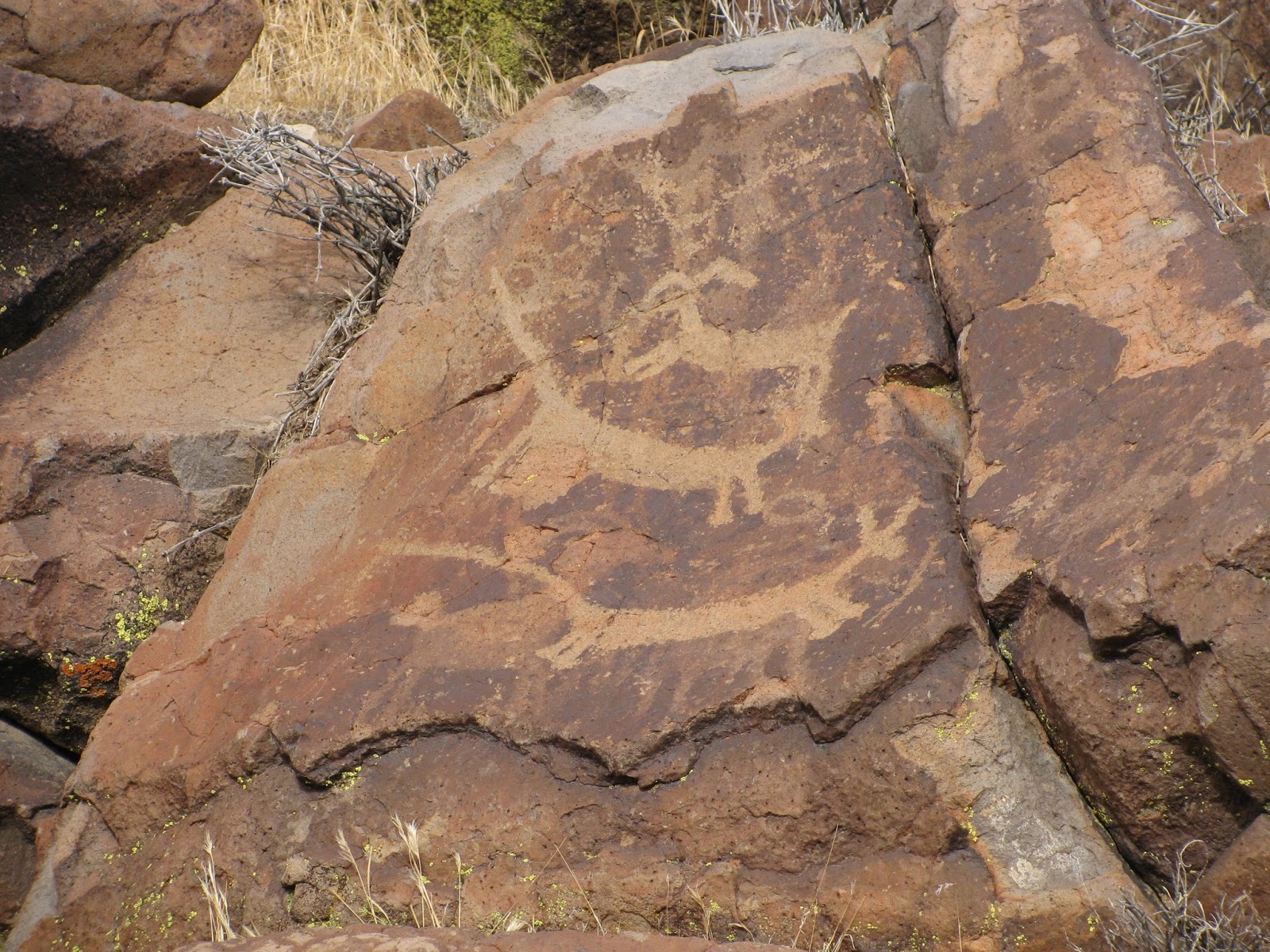
Representations of big horn sheep, which are thought to have been a staple of the ancient people's diet are found everywhere in many different styles. Joining the sheep are humanoid figures, medicine bags, deer, dogs, geometric patterns and any number of other elements.
As we make our way down the canyon, the density of the petroglyphs doesn't seem to let up. In places, the canyon walls climb a bit taller and eventually, we are forced to climb down a dry basalt waterfall. It makes for a bit of a challenge for some of my companions, but it's not all that difficult to traverse.
Finally, with the sun starting to grow low in the sky, we decide to turn back. Our guide mentions that while the rock art continues on a bit further down the canyon, we have seen most of it. I would estimate we have encountered 15-20 thousand glyphs to this point - WOW!
Turning back, we climb back up the waterfall and find a wild burrow digging in the dry creek bed for some sign of moisture. He quickly makes his way out of the canyon and then watches us from above as we make our way back to the cars. What an amazing trip.
The hike wasn't even two miles out-and-back, but the richness of the rock art is beyond belief. Unlike most of my posts, I'm going to post a large number of pictures with this blog, as it's all about the rock art.
The meetup group scheduled another hike into the Lakes Basin area near Graeagle, CA for today. This trip was to visit a few of the regions many lakes, specifically Round Lake, Big Bear Lake, Little Bear Lake and Cub Lake. Everyone was pretty sure there would be little to no snow on the trail and so most of us left our gaiters and snowshoes behind for the hike.
As normal we met at one of our normal spots and carpooled the hour or so up to the trail head. Sixteen of us in all, spread into five cars made the trip. When we arrived at the trailhead, we were greeted with a few inches of slushy snow in the parking lot - not a good sign. We quickly organize and get moving.
As we enter the forest, we find a fair amount of snow on the trail. The air temperature is fairly mild and makes the snow pretty slushy in most places, though it has some crunch to it in the shade. Still it's not very deep during this first part of the trail.
Soon, we pass the first of many frozen ponds as we begin the ascent up to Round Lake. Here the snow begins to get deeper, approaching depths of two to three feet in sections. For the next couple of miles, I should probably change the name of the hike to "Adventures in Post-holing", as one step after the next sees myself and many others sinking deep into the snow. It makes the going incredibly slow and laborious, but we persevere.
Arriving at Round Lake, the bowl surrounding the lake is covered with more snow, but the contrast of the clear bluish-green water against the white backdrop makes for a beautiful view. As we make our way around the nearside of the lake, I'm wishing I had a pair of hiking poles to use, as the snowbank is slick and the slightest slip of the foot would see one of us sliding twenty feet down into the icy lake waters. Luckily, we traverse the distance without anyone taking a dip.
The going doesn't get much better as we continue around to Silver Lake. Post-holing continues to be the theme of the adventure. We're all enjoying ourselves just hanging out in our beloved outdoors, but the constant sinking into the snow is somewhat frustrating for everyone.
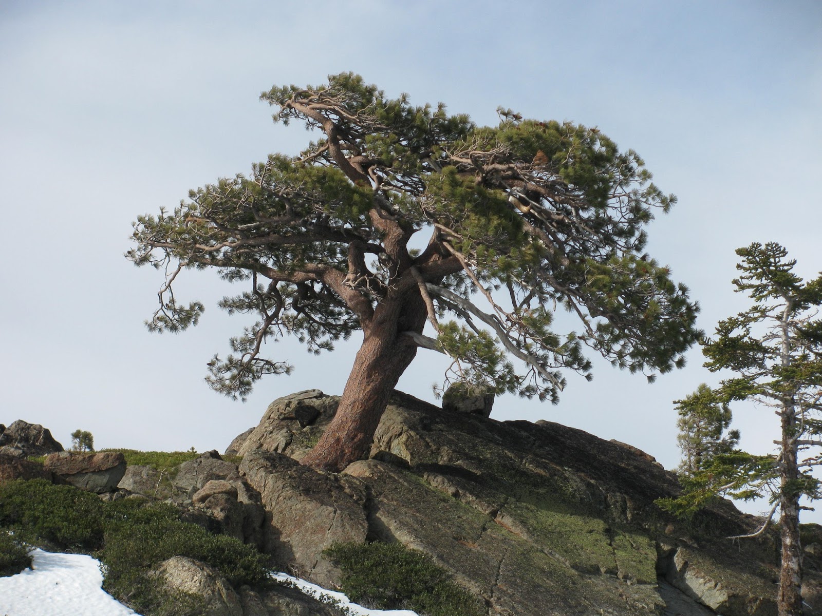
As we make the turn back around to drop down to the Bear Lakes, we note a lone tree on the ridge line. It's growing out of the granite and an angle and we all agree what a great picture it would make.
Arriving at Big Bear Lake, we don't find much relief in the post-holing. Like the other alpine lakes in this area that we have visited, the snow makes for a pristine view. We pass the other two smaller lakes and eventually arrive back a the fork that leads us back to the trail head. This last section is mostly snow-free and it provides some much appreciated relief from the earlier part of the trail.
In total, we only put in about 4.3 miles today, but the constant post-holing certainly made it a challenging adventure. As usual when doing hikes in this area, the group heads up the road to the Brewers Lair and pulls out a cornucopia of snack food to enjoy with each other while we dip on some good brews and cringe at a barrage of mostly cheesy jokes. I do love this group and I'm glad to be part of it.