Living in an area with so many overnight backpacking destinations nearby is truly amazing. This weekend's trip was into the Desolation Wilderness with my friend Bill. We had tried to do this trip about a month ago, but spring rains made us change our minds. This weekend though turned out to be perfect. I had acquired overnight back country permits with our itinerary starting us at the Echo Lakes, camping at Lake Aloha, and exiting at the Eagle Falls trail head.
Knowing that parking would be an issue, we met at 6:00 AM and drove our jeeps down to the Eagle Falls trail head. I dropped my jeep off and then we loaded our packs into Bill's jeep and we made our way through South Lake Tahoe and to the Echo Lakes trail head. We were on the trail by 8:30 or so, and this first day was intended to be pretty easy.
I have day hiked from Echo Lakes to Lake Aloha in the past and it is a beautiful hike. As we make our way past both Lower and Upper Echo lake, Bill comments on the beauty of the lakes. As we reach the Lake of the Woods side trail, I mention that it is actually one of the most beautiful alpine lakes I have ever seen. Knowing that our mileage for the day is going to be minimal, we decide to hike down to the hidden lake on the side trail.
As we make our way down the switchbacks, we are little surprised to see Forestry Service Rangers coming up from the lake. They are extremely friendly and ask about our plans, noticing that we have more on our backs than just an average day-hiker. I pull out our permits and they offer some friendly advice about camping spots.
A short time later, we arrive at the Lake of the Woods and Bill agrees that it is an amazing site to witness. Something about this little hidden lake just appeals to me. It's clear, blue waters, its location tucked away in a small little hidden area, and just the simple fact that it is always so peaceful down here. Great place for anyone just wanting a little peace and quiet. After a short rest, we start up the trail leading out of the depression containing this great little lake. The climb is steep, but knowing that our destination for the evening is just a short distance ahead, we make it with ease.
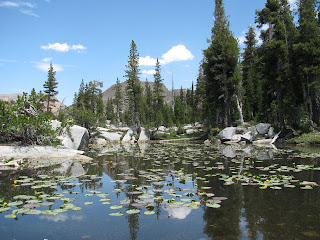
We arrive at the southern end of Lake Aloha, which has a lot more water in than it did the last time I was here. It actually looks like a lake this time, as opposed to being a collection of puddles, as it was on my last visit. This is one of the larger lakes we will visit on this trip and so we begin walking around the edge, looking for a suitable campsite. I'm a little surprised to see a small pond (which probably connects to the lake at higher water levels) with lily pads in it. Awesome!!

We decide on a campsite and begin to set up camp. It's still early in the day and as I didn't get a lot of sleep the night before, I decide to take a short nap. It's hot, but not unbearable. After about 45 minutes, I awake and decide to fix a late lunch - freeze dried three-cheese chicken pasta. It's actually pretty good. Bill and I spend the remainder of the afternoon just relaxing and taking in the sun at this cool, alpine lake. I also get quite a few shots of the lake, including a really nice one at sunset.

Early to bed and early to rise, I awake at about 5 AM. It's cool, but not cold, but go ahead and put on some fresh clothes before leaving the tent. I actually slept pretty well overall, considering it was just my sleeping pad and sleeping bag on top of a slab of granite. And then I step outside . . . to be attacked by a never-ending swarm of vicious flesh-eating mosquitoes. This will be a theme for most of the day, but where were these little bastards yesterday. We saw no sign of them. I jump back in my tent and pack as much as possible, safe from the little vampires, but eventually, I have to go back outside and pack the tent itself. The blitzkrieg is relentless and Bill and I decide to skip breakfast in an effort to flee this onslaught. He finished packing his tent slightly before I did and so we make a dash for the trail. Away from the water, it is a little better, but they are still present.
Not knowing exactly how far around the lake we had come yesterday, we make a couple of missteps in finding the correct trail, but eventually, we find the right one. Interestingly, we encounter the first of several PCT thru-hikers as we fill our water receptacles at from the lake. Hikers are almost always such great people and long-distance thru-hikers exemplify that statement. We fill our water bottles and make the turn towards Dick's Pass.
It's all uphill for here or so I thought. Dick's Pass, at 9380 ft, is the highest point on my planned trail, but before we start the climb up to the pass, we drop down a couple of hundred feet to pass by more beautiful alpine lakes . . . or mosquito breeding grounds, as is more appropriate today. The lakes are truly amazing, but the little blood-suckers attack in force once again. We pass by Heather Lake, Susie Lake, and begin making our way to Gilmore Lake.

As we start past Gilmore Lake, I am so overwhelmed by the mosquito assault, I miss a turn. I move my hand over my arm to free my skin from the attack and roll over 4-6 mosquitoes, only to use switch hands and repeat the process on my other arm. I must look quite comical as I make my way down the trail slapping and brushing the little bastards off of me. I see a nice hiker with her dog near the shore of Gilmore Lake and ask if she and her companions might have some repellent that I could use. She suggests going up the hill to their main campsite. As I start up that way, Bill calls me from the other trail, which I should have been one. I head back, but decide to cut through the woods after all to ask about the mosquito repellent. The extremely nice hikers offer up what they have, even though they have to pull it from the bottom of their pack. I bath in the stuff. It's a terribly pungent smell, but if it makes me unappetizing to these guys, then it's all worth it. I thank the group and we make our way back to the main trail. I laugh as I see the mosquitoes attempt to land on me, but notice the scent of the repellent and go on their way. . . . finally, some relief!!! Next challenge of the day: the relentless hike up to Dick's Pass.

From this point, it's straight uphill as we approach Dick's Pass. It's steep, but not terrible. I think Bill struggles with it a little bit, but slow and steady wins the race and after several switchbacks, we finally reach the top. The area around the high point of the trail is an open grassy meadow with sprawling views of the entire Desolation Wilderness Area. We take a few snapshots and start down the hill . . . and down . . . and down . . . and down some more.
We pass above and then along side Dick's Lake and the are forced to make a decision. Should we bypass the Velma lakes and take the cut-off towards Eagle Falls or not. After our battle with the mosquitoes, we agree that the sooner we get back to the jeep to clean-up the mosquito carcass shrapnel from our clothes and skin, the better. This short-cut will save us about 2 miles.
Continuing on past lake after lake, we start to see a increase in the number of hikers on the trail, mostly day-hikers coming up from the Eagle Falls trail head. We manage to stay on the proper trail with the help of our map-reading skills and a little confirmation from hikers passing us in the other direction.
Eventually, we see Eagle Lake come into view below us and I know we are almost to the jeep. My knees are getting a little sore from all of granite steps, but we double our pace in anticipation of the end of the trail. We finally reach the bridge cross over Eagle Falls and realize we literally have 5 minutes more to go.
Finally, we reach the jeep. This was a great hike with some amazing country. I served my place in the food chain by providing a buffet for swarm after swarm of mosquito. I feel as though I have done a lot. In total, we hike almost 24 miles over the two days: 8 miles day 1 and about 16 miles day 2. Not bad days, but always more difficult with a full backpack strapped to me. I hope to do this trail again someday, and possibly hit the Velma Lakes, but I will definitely bring a good supply of high-powered mosquito repellent . . . and possibly a flame-thrower!!
I've been trying to get Half Dome cable permits for the last couple of years to no avail. This year, though, I got lucky and was able to secure some. Half Dome, for those that might be unaware, is the iconic granite monolith on the south (right side as you look into the valley) side of Yosemite Valley. I hiked it about ten years ago, prior to the lottery system being implemented. The lottery system is designed to limit the number of daredevils, and therefore the danger of, climbing the steel cables which make up the climax of the hike.
I invited several of my friends to join me, but due to prior obligations or overall unpreparedness for the trek that is Half Dome, most had to decline. Two brave co-workers, Bill and Van, did take me up on it though. Van also brought along his 13 year-old son, Logan. I have hiked with both Bill and Van in the past and had no concerns with there ability to do the hike, even though it was their first time.
Knowing this would be an all day affair, we left Reno at 4:00 AM and started the four hour drive to Yosemite Valley. While the park is only about two and a half hours from Reno, getting to the valley itself is another 90 or so minutes on top of that. We arrived at Curry Village at about 8:30 AM and found parking in the very busy lot. After checking to ensure we were all geared up, we departed the lot and headed the half-mile or so towards the trail head.
The trail to the top of Half Dome is a long extension to the Mist Trail, so named because it passes by a couple of famous waterfalls that give off a cooling mist to their vicinity. The first section of the well-traveled trail is broken pavement. As we make are way up the trail, alongside the Merced River, some of our fellow adventures point out a bobcat that had hidden from the crowds behind a large granite boulder. It's always nice to see the wildlife here in the park.

Continuing on, we begin hearing the rumbling of Nevada Falls in the distance. Eventually reaching a solidly constructed bridge over the racing river, we take a few minutes to get a snack and take advantage of the cool river water. While the trail has been relatively easy so far, I know what is to come and take full advantage of this short break and calorie stock-up. A cliff bar, some jerky, and another breakfast make for a good calorie boost. My companions and I admire Half Dome in the distance and I point out the path that we will follow up the backside of the mighty monolith. Even though I have hiked the trail before, looking at it from this perspective is still somewhat daunting. We break from our makeshift lunch spot and hit the trail hard once again.

I'm feeling extremely good and I push the pace pretty hard. Bill, Van, and Logan do a great job of keeping up as we continue up the path. My last time on this trail, I suffered a pretty severe knee injury and while I finished the hike on that trip, I could barely walk for the two days afterwards. This trip, it was Van who would suffer from a similar issue. His quads started seizing up at about the half way mark and we slowed our pace a bit to give him time to recover. An electrolyte boost and he tries to give it another go, but tells me to go on without him. He will either join us on top or wait for us at the top of Nevada Falls.
With arrangements made, I start pushing the pace hard once again. As we continue on up the trail, we finally reach the turn and can see the cables ahead of us . . . calling to us. Once again, we stop for a bit before the final push up the mountain. Van and Logan rejoin us and resolve to complete the trail. Just about that time, a small rattlesnake decides to cross the trail in front of us and of course, I have to take a shot of the little guy.

The climb up Sub Dome is made up of a series of crisscrossing granite-carved steps and sheets of granite that must be navigated to reach the saddle between Sub Dome and Half Dome. These steps are a killer on the knees and a fall in any direction could easily be fatal. The danger factor is increased by the fact that people are going up and down the steps at the same time and often must figure out a way to pass by each other. The heat of the day is upon us and there is no where to go but up beyond the tree-line. I'm not sure if trees are absent because of the elevation or simply because the surface is far too steep for anything to grip on very well. Either way the sun beats down on us pretty hard as we force ourselves up the steps.

Reaching the saddle, we put on our gloves and wait our turn to start up the cables. While this is not necessarily a matter of rock-climbing, it does requite a fair amount of upper-body strength. The cables are spaced about 4 feet apart and attached to the mountainside via being threaded through the eyes of steel poles that have been drilled into the granite. The pairs of poles are spaced about 12 feet apart and in most cases have a 2 x 4 laid over and attached to the poles. These boards are the saving grace of the climb as it allows adventurers to take a portion of the weight off of their arms periodically. The climb is hard and many of the individuals on the cables, both going up and coming down, are obviously frightened. Rightfully so, a misstep could easily be deadly, but we eventually reach the summit. I wait for my companions and we all take a breather before exploring the much flatter summit.

The views from up here are truly amazing. A 360 degree view of Yosemite is the reward for our hard work. Looking over the sheer face of Half Dome, one is looking nearly a mile straight down to the valley floor. It is not for the meek or those scared of heights. The day is winding down and after about 45-minutes of relaxing and exploring, we begin to make our way down the cables. Down is easier and much more about control that exertion. The danger is also a bit greater as the granite is very slick. Descending safely is simply a matter of paying close attention to one's contact points and ensuring that one hand is move at at a time.

As we hit the bottom, we agree that we want to get back to the trail head pretty quick and so we push hard. Looking at my Walkmeter application and the ground we are covering, I think we were doing 15 minute miles for a good portion of the return trip. My water is running very low and once we reach Nevada Falls, I pull out the Life Straw that was a Christmas Present a couple of years ago and begin to take refreshment from the cool river passing by.
We decide to take a slightly different path back to the car, which will take us past Vernal Falls. While we are ware that this path is much steeper, it is also about a mile-and-a-half shorter and gives us access to some new landmarks to see. Once we reach the falls, we are rewarded by a cooling mist bouncing off of the rocks. It feels amazing for those of us that sweaty, sore, and tired from a long day's hike.
We arrive back at the car at dusk and take a few minutes to wipe the grit, dirt, and sweat off before heading to the Awanhee to grab a bite to eat. All in all, it was a 21-mile hike and is certainly, one of the most difficult I have ever done. I think everyone really enjoyed themselves though and I would highly recommend this trail to anyone that wants to challenge themselves.
With a couple of bigger hikes coming up in the near future, I've been trying to get my self in shape and what better way than to do a quick hike up to Hunter Creek Falls after work. While it's an easy trail and I've done (and even blogged) about it in the past, it's just about perfect to start and finish before it gets too dark.
Changing out of my work clothes and throwing some proper hiker-wear on, I arrived at the trail head around 5:30. The trail is well traveled, but tonight seemingly not all that popular. That said I do encounter a couple of groups making their way back to the trail head.
Below the trail, the creek tears a path through the vegetation. Obviously, the recent rain Reno has received has bolstered the local water supply. The rushing stream makes for a nice companion on the way up to the falls. The bounty of the recent rains can also be seen in the huge number and variety of wildflowers all along the trail.
Reaching the falls, I stop for a bit to grab a quick snack and relax before turning around and heading back. As dusk approaches, I reach the trail head to be greeted by a nice view of the lights of Downtown Reno. Only about 6.5 miles in total, but well worth it on a weeknight.


