Sunday, August 16, 2015

Dardanelles Half-Loop . . . and then Some (Tuolumne County, California)


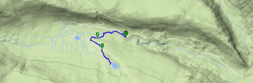
My intention was to hike to Clouds Rest in Yosemite today, but as of about eleven o'clock last night, Tioga Pass (CA 120) was closed due to an encroaching wildfire. With no easy way to get into the park, I had to change my plans. My friend Bill was along for the ride and we met about five in the morning to decide where to put some miles in. We decided on the Dardanelles Loop hike near Sonora Pass. Our intention was for a seven or so mile hike, but it turned out to be much, much more.

The Dardanelles, from my research, are the remains of an ancient volcanic rock formation, which has eroded away and left only some high buttes or mesas. From the pictures I have seen, they are striking as they tower over the surrounding landscape. It's a hike that has been on my list for a year or so. I was happy for a chance to give it a go.

Making our way up the long rough gravel forest service road, we arrive at the County Line Trail Head. As we park and begin getting our day packs set up, we are approached by a group of guys backpackers with desperate looks on their faces. They have been backpacking through the area, but now need to get water to another band of their large group that has been stranded on the other side of a river, which will require them to swim across. They politely and understanding ask for our help, which would involve driving one member around from Sonora Pass, where we currently are, to Ebbets Pass to the North. Bill and I talk it over and agree to assist, but explain that we had driven three hours to get here and want to get our hike in first. Completely sympathetic they are more than happy to let us get our seven miles in before giving them the ride they need. 

We hit the trail and are almost immediately crossing paths with several other backpackers, including several groups of young teenagers with their adult guides. I haven't checked, but I think this part of the trial may be shared with the PCT, which would explain the volume of foot traffic. 


Making our way down some dusty steps, we begin to catch our first site of the Dardenelles West towering over us. It's quite a site, but with the sun in our eyes, the pictures aren't the best. As we make our way on around the butte, we find better and better views, including some neat little grassy marshes.


By this point, I had fully expected to see our turn to cross over the saddle between the West and North Buttes, but even watching for the turn keenly doesn't supply a path. We continue on and arrive at the nearly dry Spicer Meadow Reservoir. From the looks of things, this was at one time a very large body of water, but all we see before us is a dry lake bed with a small puddle at one end. This drought has been so tough on the land.


Keeping Dardenelle West in our sites as best as we can, begin circling around Dardnelle North, which gives me some cause for concern, as I believed our trail should have taken a right turn by now. We agree to continue forward on the trail we see, in the hopes that it will circle around eventually. Crossing over a couple of small streams and a foot bridge, we eventually reach a point where we decide that we have missed the turn. We are now almost nine miles in. 


After some discussion, we agree to turn back the way we came, as we have no idea how much further this trail goes before turning back. It's beautiful country, but we have limited food and water, and our seven mile hike will now be at least seventeen miles. Bill and I are both pretty hearty hikers and so, we don't worry, but we do begin making our way back the way we came.

Pushing our pace pretty hard for the first couple of miles on the return trip, my knee begins feeling the impact of a number of granite steps along the trail. Our water supply is also beginning to run dangerously low. The last several miles of the trail are torture as my knee aches with every step and Bill and I both begin to experience dehydration in the hot August sun. A mile or so from the trail head, I get a burst of energy and start pushing my pace. I know I have extra water in the jeep and while it may be hot, its still wet. We finally arrive back at the jeep and chat with the guys we had talked to earlier.

While we had expected to be gone no more than three hours, it turned into more like eight, and in that time, the guys had found other arrangements. They were understanding of our predicament and thank us for our willingness to help them. All in all, we ended up hiking 17.7 miles along this trail. With a little post-hike research, I found that the turn we were supposed to make is unmaintained and by all reports very difficult to find. Ah well, we got our exercise for the day.


Sunday, August 2, 2015

Boiling Springs Lake (Lassen Volcanic National Park, California)


My second and final stop for the day will be Boiling Springs Lake back inside Lassen Volcanic National Park. I first heard of this lake from a documentary film about the Pacific Crest Trail. When I researched it and learned that I had hiked very near the lake a few years ago, I was disappointed that I had not visited it. Since that time, I have intended on a couple of occasions to revisit the area, but until today, had not been able to follow through with those plans. 

Arriving at the PCT trail head near the Drakesbed Ranch, I start the short mile or so trail to the lake. The trail follows the nearby Hot Springs Creek, and seems to have received some nice upgrades since my last visit to the area about five years ago. The boardwalks over the marshes have been rebuilt and a new bridge offers an easy passage over the creek to the south side. As I make my way up hill towards the lake, I'm anxious to see the deadly natural wonder. 

As I see the trees clear, I realize I have arrived. The lake itself looks like something Sauron from Tolkien lore would emerge from to spout evil upon the Earth. It's mint green waters emit a constant steam as they simmer at about 125 degrees. Ample signage warns visitors to stay on the trail and avoid getting near the water, as many people have sustained serious injuries when the brittle ground gave way beneath their feet and exposed them to the hot waters and steam vents below. The lake itself is a bit smaller than I had expected and on the far side, I can see steam vents on the shore. I spend a few minutes looking around before heading back to the parking lot and making my way home. This a very cool site, but echoing the signage, be very careful if you visit - death is only a misstep away.

Subway Cave (Shasta County, California)


After the Carson City Wine Walk on Saturday, I drove up to Lassen Volcanic National Park to camp at the Butte Lake area for the weekend, hoping to get a couple of trails in on Sunday. The camping was uneventful, except for a nice light show generously provided by an encroaching thunderstorm. I awoke early Sunday morning, broke camp and made my way toward my first stop - Subway Cave. 

While I had made a brief stop here a few years ago with my friend Nick, I didn't have the opportunity or equipment to take many pictures. I decided to fix that this time. The cave itself is technically just outside the park's borders and just a hundred or so yards east of the junction of highways 44 and 89. I parked and made my way into the blackness. The cave has always fascinated me with it's size and relatively smooth walls, but as I understand it, this is fairly typical of a lava tube cave, which this is. The darkness, however, is complete. As the entrances to the cave get lost around corners, the light fades into non-existence and the visitor is left with nothing but true blackness. Thankfully, this time I brought a head-lamp. The cave tour itself is only a few hundred yards, but towards the end, I am taken by an area of cave in, where it seems part of the ceiling collapsed into a pile of rubble on the cave floor. I snap a few shots and make my way back to the jeep.


Saturday, August 1, 2015

Bowers Mansion (Washoe County, Nevada)


To start off another busy weekend, I and some friends, while on our way to the Carson City Wine Walk, decided to stop for a quick tour of the Bower's Mansion in Washoe Valley. I've passed by the landmark many times and wondered about it's historical significance. Today, I get to learn about it. We arrive a minute or two after the scheduled tour time, but as there are no other visitors, the tour-guide is more than happy to escort our small party through the mansion.

As I understand it from the guide's description, the Bowers were Nevada's first millionaires, making a mint in the early shafts of the famous Comstock Lode. The mansion they built with their fortune was one of the first signs of the riches many others would find below the nearby communities of Virginia City and Goldfield. The original lavish decor was later stripped, when the family fell on harder times, but locals have donated many period pieces to refurnish the mansion over the decades. 

In addition to selling off much of the furnishing, the mansion was also turned into something of a resort at the turn of the previous century. It's wide open spaces and terrific views of Washoe Valley make it an ideal spot for picnics and family outings. Eventually, the mansion fell into decay, but was later purchased and refurbished, only to come to life again as a resort in the 1940's. Still later, the mansion was acquired by the county and turned into a park, memorializing the amazing riches found in the hills nearby.

As it turns out, Mr. Sandy Bowers, for whom the mansion is named was born somewhere in Madison County, Illinois before heading west in search if his fortune. The caretakers of the park have very limited information on his early history. I happen to also have been born and raised in Madison County, Illinois. As I mention this to the guide, we begin discussing possible resources she may be able to pursue more information about Mr. Bowers' early years. I suggest contacting the Hayner Library Genalogical Center and provide her some contact information. I hope this lead proves fruitful, as I would be glad to have contributed increasing the park's knowledge of their namesake.