Saturday, June 30, 2018

Sawtooth Loop Trail (Placer County, California)


Sometimes, you just want a trail to put a few miles in on. After reading about the Sawtooth Loop Trail near Truckee, CA, I thought I had found just such a trail. Leaving Reno about 8:30am and making the 40-ish mile drive across Donner Pass to Truckee, CA, I arrived at the trail head just a short time later and started the hike.

This is a popular mountain bike trail and the number of cars at the trail head with bike racks testify to that fact. That said, I get a couple of miles down the trail before encountering any of them. The trail is perhaps the most windy and twisting trail I have ever hiked and I'm forced to question why it was built this way. I would understand if the terrain or erosion control required it, but this area, while setting atop a the valley carved by the Truckee River, is on a nearly flat plateau. There is no good reason I can think of to cut the trail like this except to make it interesting for the mountain bikers. Oh well, it's easy going.


While there are a couple of spots granting a vista of the river valley below, they are few and far between. What this trail has a lot of is forest. Forest much like that which covers the Sierra Nevada is really the only environment here. Ponderosa pines, manzanita bushes, other trees and bushes I can't readily identify, and milkweed dominate the landscape. I'm especially happy to see the milkweed, as it is essentially for the survival of the monarch butterflies. I recently attended a lecture about the challenges this beautiful species faces. The more habitat we have for them, the better chance of their survival.


As make my way around the first major bend in the trail, I'm passed by a few friendly bikers. At the bend, a side trail leads to lookout, but just as much of the other trail has been, it seems to twist and weave through the level forest unnecessarily before reaching mediocre vista point over the valley.

I return to the main trail and continue around the second bend, encountering numerous other bikers along the way. All of them are friendly and greet me as they ride past. I do find it somewhat funny, that I end up catch up to some of the bikers that passed me earlier. Apparently, between their stops and my quick hiking pace, we're not that far apart.

Finally, reaching a multi-tined fork in the trial that sees the intersection of a forest road with the two forks of the trail, I get turned around slightly and walk a few yards down the wrong path before getting my bearings and returning to the proper path. From here, I'm simply retreading the first couple miles of the trail, which I hiked in on a couple of hours ago.

Finally reaching the jeep at the trail head, I note that I've covered right at 11.4 miles this morning. The trail was easy, but I must say, a little boring. There are really no overly interesting things to see along this trail. If you're simply looking for some quite time and some forest miles, this trail is probably for you, but otherwise, I would look for something a little more interesting.

Friday, June 22, 2018

Camping in the Santa Rosa Range (Humboldt County, Nevada)


For my adventure this weekend, I decided to join the meetup group I often hike with for a camping/hiking trip into the Santa Rosa Range north of Winnemucca, NV. Though most of the group drove out Thursday, I didn't want to burn any vacation days for the trip and so, I made the 3+ hour journey Friday after work. Another member of the group, Michael, asked if he could carpool out with me and I was happy to share the fuel costs and have some company for the long drive.

We drove across Hinkey Summit, which I had visited a few months back as dusk approached and finally reached the remote and somewhat hidden Lye Creek Campground just about 8:30 PM. Our friends greeted us and showed us to the sites they had saved for us. I quickly put up my tent and got my bedding ready. Michael did the same nearby and afterwards we joined the large group around the campfire they had going a few yards from where I parked.

After sharing a few beers, some snacks, and an ample amount of campfire chatter, we noticed the hour getting late and all decided to turn in for the night. As everyone departed for their nearby campsites, we agreed to meet back at the large fire ring at 8:00 am to start a day hike into the surrounding country.

While I do love the minimalist nature of backpacking, there is also something to be said for the comforts of car camping. Without the need to worry about ounces, I brought three sleeping pads and much much bulkier sleeping bag. A light cool breeze swept through my tent as I crawled into my warm bag and a moment or two later, I was out for the count.

There is something to be said about the way we awake to each day. In direct contrast to the obnoxious screaming alarm at home, I woke this morning to the sounds of a flowing creek a mere 10 yards from me and birdsong above. So serene it was, I decided to lay there for just a little bit and enjoy before getting up and fixing some breakfast.


The group had hiked up to Granite Peak, the tallest in the range, on Friday before I arrived and today, the plan was to hike the jeep trails to a short N/S ridge just northwest of our campground. True to practice, we departed at just a couple of minutes after 8:00 am. Starting out up the gradual incline of a jeep trail heading west and further into the mountains, the group of a dozen or so hikers start spreading out according to pace. When we reach a fork in the road, we wait for everyone to catch up and decide to leave the road and start up the much steeper incline towards the ridge. 


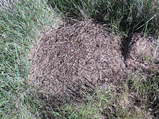
Along the way, we note a hill of harvester ants busy with activity. Hundreds of them packed into the small space, but they seem undisturbed by us. Though there is a bit of rock scrambling near the top, everyone makes it safe and without incident. From here, the views are majestic. In every direction, I can see at least fifty miles, perhaps more. We break for a quick snack while sitting on the loose talus, before starting the precarious scramble down and following the fence line until we reach another jeep trail, which we are pretty sure connects back to our original path out of the campground. Our suspicion is correct and after putting in about 5.7 miles on the trail, we find ourselves back at the campground. 


Everyone returns to their respective sites to refresh and change, before reconvening at the campfire. My friend Vijay asks if not to tired from the morning hike, would I be willing to drive the jeep up to the natural arch, which I visited last winter, and possibly climb to the peak of the mountain above, the actual Hinkey Summit. As I'm not really tired at all, I'm actually rather excited to get in some more exercise this afternoon. 


Vijay and Michael climb in the jeep and we head the mile or so up the road to the pass. As I turn to drive up the steep, rocky road that leads to the top of the Arch, Vijay is somewhat surprised, as he didn't think we could drive up this far. The road poses very little challenge to my jeep and we park near the top of the arch to admire the natural splendor. After a few minutes, we decide to hike up the road a bit further, though the jeep could have made it without an issue. 

After hitting the high ridge on the road, I step off the jeep trail and begin to bushwhack my way up the steep northern slope of Hinkey Summit. Vijay follows a short distance behind, but Michael decides to head back to the jeep. It's slow going as there is no trail, ample rocks and bushes, and a heart-pounding incline. The final 30-ish feet to the peak is extremely precarious and I must place my feet extremely carefully as the talus is very brittle and subject to breaking under stress. At the top, I find and sign a small register that someone has placed into a glass jar and stashed under a rock for safe keeping. Vijay joins me a few minutes later and we take in the view from ~8,500 ft, before carefully making our way back down the slope and to the campground.

Returning to camp, we find our comrades enjoying each others company over beer, wine and table games. We join them at the campfire and enjoy dinner together. The fire rages deep into the evening and I eventually decide to turn in for the night.

I sleep in a bit later this morning, but again wake to the sounds of the creek and birdsong. Once awake, I start breaking down my camp. I had told Michael and the rest of the group that I wanted to get an early start and get back in Reno with some daylight left. As we make our way down the mountain, we encounter a small rattlesnake on the jeep trail. He coils and prepares to strike at the jeep, but allows us to pass without incident, though his fangs might have problems with my tires and/or undercarriage.


Our last view as we make our way down Hinkey Summit Road are hillsides covered with a sea of golden wildflowers - incredibly gorgeous. It was a fantastic weekend, full of beautiful countrysides, good friends, and lots of peace.

Saturday, June 16, 2018

Rock Tahoe Half-Marathon 2018 (Douglas County, Nevada)


Another year, another Rock Tahoe Half-Marathon. This will be my third year running this half along the gorgeously scenic eastern side of Lake Tahoe. I often choose not to repeat specific half-marathons, but I've always thought of this one as the best organized of any I have run and that helps to keep bringing me back.

Like last year, I decided to stay up at the lake instead of getting up at 3:00 am to make the trip. The Hard Rock Hotel, which serves as sponsor and finish line has pretty nice rooms and since the packet pickup, shuttle to the starting line, and the after party are all here, it makes everything nice and convenient. After getting a pretty nice night of sleep in my ninth floor room overlooking the lake, I wake at 5:15 to get ready to run. After getting a few calories in me, putting some sunscreen on, getting all of my running-wear on, and grabbing a bottle of water, I head outside to the shuttle pick up.


The race provides a number of shuttles from the hotel to the starting line at Spooner Lake, some thirteen miles to the north along highway 50. Two start times are scheduled. Walkers and those that don't expect to complete the race in under 3-ish hours, get to start an hour earlier at 7:00 am, while runners start at 8:00 am. This policy is in place to ensure the first person to cross the finish line is actually the winner of the race. 

Unlike two years ago when it snowed on us a bit at the starting line, the temperature and weather are absolutely perfect. My weather app reports 49° and there isn't a cloud in the sky above us - perfect running weather! While we wait for the start of the race, I visit with some friends, both new and old. Runners are a pretty friendly crowd. As we approach the starting time, all 3,000 or so of us starting moving up towards the startling line and organizing ourselves into groups with the pacers. Though I'm nursing an ankle I rolled a week ago, I feel pretty strong this morning and put myself with the 2:15 group. 

With a quick countdown and the sound of a air horn, we're off. The start is always congested, but as we make the turn out of the parking area and onto the highway, which has the right most lane closed to cars for this event, the pack starts to open up. 

As always, the first 2-ish miles are down hill as we run down the highway from Donner Summit, loosing a few hundred feet of elevation as we go. I'm feeling really, really good along this stretch and note that I'm pushing a sub-nine minute mile pace. Finally, at about the three mile mark, the sapphire blue waters of Lake Tahoe become visible in the distance. As we continue putting miles in, the route hugs the eastern shore of the giant alpine lake. 

After eight or so miles, I'm still feeling pretty strong, though I did decide to take it easy on many of the uphills. I do however need to stop for a bio-break at one of the aid stations. There is a short line for the two porta-potties and I loose 5-ish minutes waiting, but it's better than not-going. After relieving myself, I'm back on the trail and still feeling pretty good. The temperature has risen to what feels like about 65°, which is still great for running.


As we leave the highway to finish the last couple of miles on bike trails, I start feeling the fatigue and I'm forced to walk a few sections, especially the one with the steep uphill. For the remainder of the race, I alternate between running and walking, before finally making that last turn that brings the finish line into view. At this point, a fellow runner and I nod to each other and decide to finish strong. We both burst into a near-sprint and step through the finisher's arch.


Crossing the finish line and dropping to a walk, one of the greeters places a finisher's medal around my neck and I head towards the beer tent to get a much-deserved beer from AleworkX. My official finishing time was 2:31:34, which is not best, but also not my worst. Not having much time before I'm required to check out of my room, I head up to get a quick shower and pack my bag before returning home. As always it was a great race.

Friday, June 15, 2018

Cascade Falls (Eldorado County, California)


It's been a good day, my engineering team at work took the afternoon to go see a movie and I'm spending the night at Lake Tahoe to run a half-marathon first thing in the morning. After driving up to the lake and getting checked in, it was only about 6:30pm and I decided to get a quick hike in before crashing.

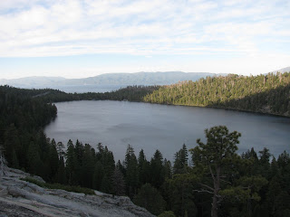
Emerald Bay is arguably the most beautiful area of Lake Tahoe. From the surrounding mountains, a number of waterfalls flow into the bay and the surrounding lakes, including Fallen Leaf Lake and Cascade Lake. One of the few waterfalls I've never visited in this area is Cascade Falls. The trail is a short one and it seems like a great choice, given the limited amount of day light I have left.

Driving the few miles from my hotel to the Bayview Campground, I park the jeep at the trail head and walk into the forest. The campground is full and there are several cars at the trail head, but a couple coming out greet me and tell me that I'll  have the falls all to myself, as there is no one else up there. 


After about a quarter-mile through the forest, the trail travels along a granite cliff that rims the southwestern side of Cascade Lake. The trail has a mile grade to it, but the more problematic part are the number of boulders strewn the length of it. It poses only a minor inconvenience though. From about a quarter of a mile away, I can hear the falls and soon it comes into view. The waterfall cascades approximately 150 feet down a forty-five degree slope before drop into the creek below, which in turn feeds the large Cascade Lake below.

After reaching the top of the falls, I begin looking around for a good place to get a shot of the entire height of Cascade Falls, but I'm not able to find any place to get a good angle. I take the best shots I can before turning and heading back to the jeep. It was only about a 1.4 mile hike, but as the dusk is now upon me, I'm content with the distance. Besides, I'm running a half-marathon in 12-ish hours.

Sunday, June 10, 2018

Patriarch Grove (Mono County, California)


The Ancient Bristlecone Pine forest high on the summits of the White Mountains that straddle the California-Nevada border are home to the oldest living trees on earth. I've visited the area a couple of times in the past, but I've never driven to the northernmost grove of the area, the Patriarch Grove. After spending the night in nearby Bishop, CA, I decided to head up into the mountains and seek out the open-air museum.

Driving past the Forest Service's visitor center, the road abruptly becomes washboard gravel jeep trail. It's not terribly rough, but it is a bit bumpy. Twelve miles beyond, I finally reach the Patriarch Grove. As I exit the jeep, I can already feel how thin the air is up here at 11,500 feet. I've suffered from altitude sickness a couple of times and it's not pleasant. While I don't feel my head becoming a hot-air balloon attached to my shoulders, I do find that I have trouble catching my breath.


As my symptoms are not that bad, I decide to explore the area as I had planned. Just beyond the parking lot, I encounter the tree for which the grove is named, the Patriarch. While not the oldest Bristlecone Pine, it is the largest one ever discovered. In comparison to other specimen I've seen, this one is absolutely massive with a segmented trunk probably 20 feet in circumference.

The entire area up here is windswept and pretty much lifeless, save these ancient sentinels. Bristlecones have adapted to thrive in the highly acidic dolomite rich soils of these mountain tops. As not much else can survive in this soil, these trees are pretty much all alone, though the twisted and gnarled trunks give testament to the struggle for survival that takes place here. Many of these trees are more than three millennia old. The oldest one ever discovered was estimated to be 4,800 years old. Let that sink in for a moment. These Trees were already well established when the the Great Pyramid was constructed on the Giza Plateau on the other side of the world.


It's like another world up here. The white dolomite soil covers the landscape, with the occasional Bristlecone poking through. To the west, the highest of the Sierra Nevadas still have a fair amount of snow on them, while to the east, the vast desert of the Great Basin opens up. Some of the trees appear mostly lifeless with several limbs appearing to have died off centuries ago, and with only the most meager signs of life poking out of other limbs. Due to the nearly sterile environment at this altitude, the trees that have finally succumb to time take hundreds of years to decay.


On the nearby hillsides, a number of dead specimen remain standing and will likely still be there for centuries to come. I'm humbled every time I visit any of these groves. All of them exist in areas that seem other-worldly. Enough though, I still have some exploration to do today. After hiking both loops through the grove, I see that I've only hiked a little over a mile, but even with the difficulty breathing at this elevation, it was totally worth the visit.

Saturday, June 9, 2018

Kyburz Flat Petroglyphs (Sierra County, California)


Last stop of the day is at the Kyburz Flat Interpretive Site, specifically to see a petroglyph panel. Again, my directions and the information panels guide me right to the site. The panel here was once a solid piece of stone, but at some point in the distant past, it split into three and collapsed. The panel itself is simply a large number cupules drilled into the stone. The purpose of cupules is debated by scholars, but I suspect there were a remnant of some daily function of the ancient peoples.

Loves Falls (Sierra County, California)


Next on the list is Loves Falls, which is only a few miles from Lakes Basin. As I arrive in the trailhead, which happens to be a road-crossing for the PCT, I encounter three thru-hikers. The nice chaps with a British accent ask if I would be willing to give them a ride into Sierra City. I tell them I was planning a short hike to the falls and that if they are still there when I return, we'll figure out a way to get them and their gear down the road to their supply.

I cross the street and follow the short trail down to the falls. This is actually the PCT that I'm hiking on and a tall foot-bridge has been constructed to allow the trail to cross the North Yuba River just above the falls. This whole area is really gorgeous. The river cuts a swath through the granite here and plows over the short falls, called Loves Falls. It's only about a ten to fifteen foot drop, but the river rages over it.


I decided to head up the trail a bit further to see if there are any better views. Across the bridge, a number of switchbacks head up the hillside, but after covering another half-mile or so beyond the falls, I've pretty much lost view of the river and decide to head back to the jeep.

Returning to the trailhead, the Brits seem to have gotten a ride as they are no-where to be found. I wish them well, but it would have been tough to fit all three plus their packs into the jeep. Checking my phone, I see I've hiked about 2.4 miles. Not much, but a good little hike to get the blood pumping.

Lakes Basin Petroglyphs (Plumas County, California)


I recently heard about a petroglyph site just south of Graeagle, in the Lakes Basin area. I've hiked this area numerous times over the years, but never knew about the site. As I had some time this morning, I decided try to find the rock art and hit a few other sites nearby.

The directions I found were on the mark, and I had no trouble at all locating the panels. Unfortunately though, the petroglyphs are fading into obscurity. The two adjacent panels face upwards and some informational panels detail the carvings, but either due to the cloudy skies above or the ravages of time, I can only locate a couple of petroglyphs on the panel. It's a little disappointing, but I'm still glad visited.

Monday, June 4, 2018

Court of Antiquity (Washoe County, Nevada)


Just east of Sparks, NV and squeezed between the Truckee River and Interstate 80, another petroglyph site has recently come to my attention. My friend, Nick, and I decided to explore the site after work this evening.

To reach the site, we literally had to pull off the side of the interstate and precariously make our way along the guard rail about 200 yards with a very steep slope and practically no catch between us and the frigid waters of the Truckee River about fifty feet below us.


Finally reaching the rhyolite terrace supposedly rich with ancient Native American, we scour the surface and quickly discover a number of petroglyphs. There are examples here similar to many other sites we have both visited in the region, including Grimes Point and Donner Summit. In all, there are approximately 20 panels scattered among the boulders and surfaces here. Most are carved into the horizontal areas, but a few have been carved into the sides of large boulders.


After spending 30 or so minutes, exploring the area, we head back to the jeep. This was definitely worth a visit, given the site's proximity to home. How had I not heard of this treasure before.

Friday, June 1, 2018

Reno-Tahoe Odyssey 2018 (Lake Tahoe, Nevada and California)


For the last fourteen years, the first Friday in June has signaled the start of the annual Reno-Tahoe Odyssey. The 178-mile relay race starting in Reno, heading west through the Sierra Nevada, into Truckee, down the western side of Lake Tahoe, around Emerald Bay, through South Lake Tahoe, down the eastern slopes of the mountains, through Carson City, into the silver-rich hills of Virginia City, and finally returning to downtown Reno has become popular event in the running community and sees a full attendance every year.

For the third year in a row, I'm running the relay with an amazing double-team called Nice Asphalt and Nice Asphalt Too. The last two years were truly amazing experiences and though we have a number of new runners this year on the team, I expect this weekend will be no different.

Planning began several months ago as our terrific captains, Jamie and Kristen began putting together the rosters, assigning legs, reserving vans, finding accommodations, and the general logistics of such an endeavor. The effort these two put into organizing this group of 24 crazy runners into a well-oil machine for the relay blows my mind every time we do it. They handle it with grace and style every year and we are all so very thankful to them for the work the do to ensure a great time is had by all.

As race-day approached, we met at Kim's, another three-time member, home to decorate and pack our two 15-passenger vans for the long journey. We comment about how new the vans smell (one of them only had 164 miles on the odometer) and how terrible they will smell in 48-hours after twelve sweaty, stinky, tired runners have lived in them for a period of between twenty and thirty hours. Unfortunately, I was only able to stay and visit with my team for a short time due to conflicting plans Thursday evening. As I will later learn, one of our other three-time runners, Raj, had a family emergency and will be unable to run, leaving us a runner down. But as always, our captains have figured out a plan to divide Raj's three legs among our remaining runners to get the miles covered.

To start the race, we arrived at Kristen's at 7:30 Friday morning to drop our cars and board our white conveyance. We drive over to the starting line at Wingfield Park. Both vans (all 23-runners) always attend the start to see our first runners kick off the event. For the first time this year, I'm one of those two first-runners, with first-timer Jasmine filling the second spot. As we stretch and attach our bibs in preparation for our quick 4.8 mile leg along the Truckee River west out of downtown Reno, our Team-members encourage us and psyche us up for the task at hand.


For our 8:45 start, we line up at the starting arch and as the countdown reaches GO, we take off out of the gate. I've unfortunately been fighting off a cold for the past few days and while I've been training pretty hard this year for this and other upcoming races, I can feel the congestion in my lungs preventing me from full lung capacity. Hopefully, it won't hinder my running too much. 


As always, it takes me a mile or so to get into my pace and breathing rhythm. As we will be running nearly fifteen miles together over the next 24-hours, Jasmine and I take this time to get to know each other a bit. Luckily, it's a nice cool morning - perfect temperatures for running. We quickly depart downtown and cross under the McCarran Loop on the western side of town, finally reaching our exchange at the far end of Mayberry Park. We slap the bracelet-batons onto our leg two Runners, Kristen and Ali, and take a couple of minutes to re-hydrate and cool down before hoping into the van and continuing on our journey. Leg 1 done!


Over the next five or so hours, we follow our active runners in the van doing our best to keep them hydrated and encouraged as they each run their first leg in turn. The country side we travel through is, as always, breathtaking. It's easy to take these mountain views for granted after having lived here for so long, but moving at a runner's pace as opposed to flashing through this area in a car, forces one to take in all of the vistas and glory of this part of the world.

Finally arriving at the first van exchange near the Boca Reservoir, we watch as our runners number 6, Kim and Amanda, reach the exchange point and hand off to runners number 7, Ryan and Chris. For a little while at least, the burden and the baton has been passed to van 2. Now we, the runners in van 1, will go to rest and re-energize. We have made arrangements to spend a few hours at a campground clubhouse a few miles from the trail. We quickly unpack some supplies and head into the picnic area to enjoy some well-earned lunch. I take advantage of the facilities shower before trying to catch a short nap on a couch. While I'm not all that tired yet, I know that I will need all the sleep I can get over the next day or so. As we get a text from van 1 that they are nearing the start of leg 11, we repack the van and head to Homewood to make our next leap frog over them.

The Homewood Mountain Resort, sitting on the western shore of Lake Tahoe, has long been the second van exchange. As Jasmine and I prepare for our next section, leg 13, we encounter numerous friends on other teams, all competing for the glory of this mighty race. This section, our most difficult, is 6.2 miles with numerous ups and downs and sections with little or now shoulder to run on. The approaching darkness also adds an additional obstacle. Wisely, the race administrators require the use of numerous lighting and reflective devices for the active runner as we travel these dangerous roads at night.


As runners 12, Tina and Kara, reach the exchange and slap the bracelet-baton's onto our wrists, Jasmine and I take off to cheers from the couple of hundred onlookers. Luckily, it's not quite dark yet and we can enjoy some of these beautiful views of the lake as we run our miles. The cool evening air makes for pleasant running. I admit that the hills on this section are really taxing my breathing and this cold affecting my lung capacity, make me struggle a fair amount. Jasmine is understanding, which I appreciate.


Darkness now fills the sky and our headlamps illuminate our way, and as we reach the exchange point, we're both pretty taxed. We hand off to our next runners and take some much needed rest. These next legs are some of the most beautiful, but unfortunately, we are only able to catch glimpses due to traveling these sections at night.

As we cycle through the van and each run our turn, we do our best to support them with layers (on or off), water, cheers of encouragement, and just ensuring they are having fun. Finally, it's time to meet up with van 2 once again, this time at the South Lake Tahoe Raley's parking lot. Though it's about 2 am, most of the stores near the Raley's (Starbucks, McDonald's, Taco Bell, etc.) remain open for business. Whether it's from a sense of profit-making or merely to support the event, the runners don't care as three thousand of us in-turn visit the establishments and take advantage of coffee, tacos, french fries - whatever keeps us going.

Now that we've again passed the burden, we had to our hotel rooms in Carson City near the next van exchange. While we won't get much sleep, even a couple of hours is much appreciated. We shuffle into a four hotel rooms and almost immediately crash on the beds, furniture, and floor. Any rest is good rest, but when the wake up calls come just before 5 am, we all reluctantly wake and get ready to go. 

We load the van and take off for the Carson City Wal-mart, the next van exchange. I'm in super light-weight day-running gear as I exit the van. Brrrrrrrrrrrrrrrr . . . . though it says the air temperature is 47 degrees, it feels much colder and I'm freezing my _____ off out here. Luckily, the leg 24 runners are quickly approaching and soon, Jasmine and I will take off on our next section. Leg 25 is an easy 3.3 miles through southern Carson City.


The hand-off made, we begin our final run of this RTO. Our route zigs and zags through neighborhoods and business areas as we begin to warm up. Very quickly, we go from freezing to burning up, as the sun rises and casts a blanket of warmth across the valley. After a mile or so, I get a major cramp in my left foot. It hurts like hell, but as this is my last leg, I refuse to let it slow me down. We continue to push and finally reach our last exchange. We hand off to Kristen and Ali before we embrace triumphantly! Our part of the the race is complete!


As our runners make their way through Carson City, out highway 50, and into the hills of Virginia City, we do our best to keep them cool and hydrated. The temperatures, while cooler than this time last year, are still a scorcher and some of these hills are massive and unrelenting. Finally, our last runners from van 1 reach the van exchange in front of the Bucket of Blood Saloon on the main drag of Virginia City. The bracelet-batons are exchanged and our runners from van 1 wander into the bar for a much-needed drink. 

Our work here essentially done, we take a few minutes to bask in the glory, before heading off to provide double van-support to the van 2 runners as they run through the hottest part of he day. We catch up with the van runners just at the end of leg 33 and from that point forward play leap frog with van 2 as we continually keep the active runners soaked from water-gun fire. It may sound like a game and while it is fun, it's much more about preventing the runners from over-heating.

As the runner's start the final part of the relay, leg 36, we head to the finish line at Idlewild Park. We quickly make our way out of the van and to the entrance of the park, where the entire team will join the active runners the last 50 or so yards to run across the finish line. As we see Tina and Kara approach, we line up and begin the jog to destiny. Cheers from the hundreds of people at the finish-line celebration ring out as all 23-of us run across the finish line. It's in the books - we've completed the 2018 Reno-Tahoe Odyssey!