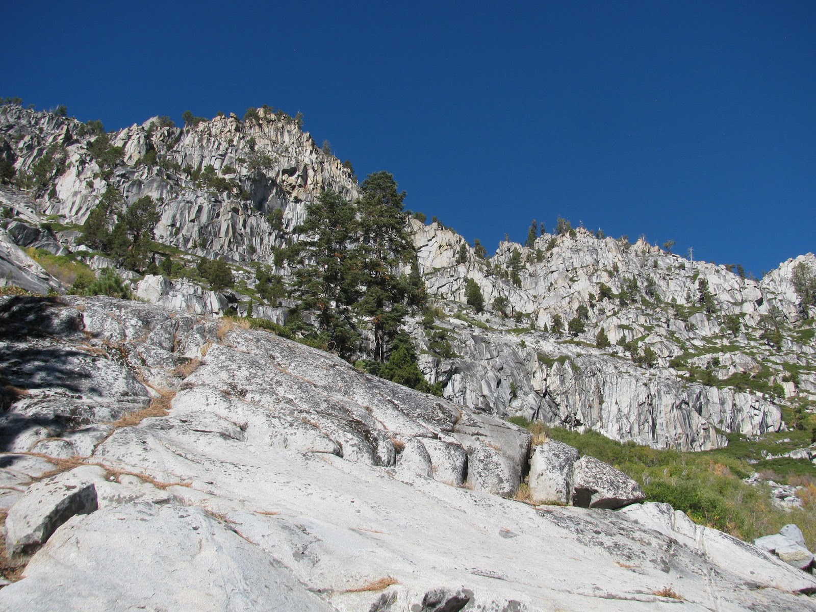
Last year about this time, I hiked to the summit of Maggie's Peak above Emerald Bay on Lake Tahoe. From the summit, I could see a beautiful lake to the south and after researching it, I found that it was named Azure lake. When I saw that one of the local meetup groups was planning a hike to it, I had to take advantage; not only because of the destination, but also because the good people that I know and have hiked with in that group. Most of us met on the west side of town and carpooled down to the Bayview Campground near South Lake Tahoe, while others just met us at the trail head.

The trail starts easy enough, but quickly devolved into a network of interconnected trails with some game trails thrown in for good measure. The sixteen of us in the group spread out to look for the continuation of the true trail and finally stumbled across it. Unfortunately, the trail was still pretty rough and had a number of fallen trees across it. We perceived and pushed on towards the lake. I always enjoy outings with this group due to the good conversations, great pace, and overall positive outlook. Most are a few years older than me, but that just adds to their charm. I hope to be as active as some of them are in a few years when I am their ages.

Finally, we reached the fork in the trail between Snow Lake and Azure Lake. Our organizer had suggested visiting the smaller and greener Snow Lake first, and so, we headed to the left. A short distance further, we reached the lake. A young couple was breaking down their camp on the granite shoreline when we arrived. It seemed like an amazing spot to pitch a tent and I may have to revisit it sometime.
We spread out on the rocks along the shoreline and started eating our packed lunches. I've recently come found and purchased small single-serve packs of herbed olives, which are great for hiking. I enjoyed a couple of packs of those, some cashews, and a Clif bar. After a short rest, we turned back the way we came, returned to the fork, and headed up towards Azure Lake.
This is where the trail, or whatever you want to call the general direction we went, got more difficult. Separating us from the lake, was a 80'ish foot tall cliff made of granite slabs and boulders. I always enjoy a little rock scrambling and this offered a great opportunity for some fun. Three of us followed this more difficult path, while the majority of the group went around to look for a more shallow ascent. It was a bit challenging, but we finally reached the top. We actually got slightly separated from the other group and after exploring the part of the lake where we popped over the ridge, we circled back around to rejoin the others, who had found a nice granite slab reaching out into the appropriately named Azure Lake. The rich blue of the waters are broken only by submerged granite reaching up from the center of the lake to form small islands. I suspect there are several more in even more dry years, but they add character to the lake.

After a short, rest we decide to head back. Once again though, we split into to different groups. The smaller group returned the way we came, but the ladies I car pooled with wanted to take a different path that was reported to be a bit easier and asked if I would join them so we could arrive at the trail head together. I generally don't like returning the same way I came in for a hike and agreed to go the 'easier' way. As it turned out, I had hiked this way back last year when I climbed Maggie's Peak, but the trail was much better maintained. We arrived back at the trail head just a few minutes after the other group enjoyed a nice cold beer. In total, my GPS tracking showed has have trekked about 7.3 miles, but some of my fellow adventurers were showing distances as great as 9+ and so, I'm unsure of the exact distance. Regardless though, it was a great hike with some great people.
From my first viewing of the movie "The Rock", which stars Nicholas Cage and Sir Sean Connery, I had always been curious about the amazing place where Connery's character is caught after a wild chase involving a Humvee and a Ferrari through the hills of San Francisco. Later today, I'm taking a professional exam at the Presidio, which just happens to be up a couple of blocks from the structure. How could I not take a walk and check it out?
Having done a little research on the building, I had learned that it was built for the 1915 Panama-Pacific Exposition as a focus for the many works of art to be presented there. It is one of the few surviving remnants of that exposition and has come to be a favorite location for weddings and other ceremonies among the city-dwellers. After getting a look at it first hand, it's not hard to imagine why.
Architecturally, the structure is in the classical European style. A garden and walkway form a wide horseshoe around one side of the artificial lagoon. At the center of the column-strewn walkway stands a large rotunda, which is beautifully ornamented with a number of murals adorning different areas. of the supporting walls and domed ceiling.
A take a few minutes to stroll around the structure admiring it and the abundance of waterfowl enjoying the lagoon before heading back to my nearby hotel room for more studying. It's just a quick diversion from the books, but one well worth it.
I had the opportunity to hike part of the Rubicon Trail, which connects Emerald Bay State Park to D.L. Bliss Start Park along the shores of Lake Tahoe, with some friends last spring, but unfortunately, we got rained out and decided to turn back. With my new interest in running, I decided to combine a revisit to that trail with a seven-ish mile trail run organized by Big Blue Adventure.
Arriving at Emerald Bay State Park on a brisk Sunday morning, I made my way to the runner sign-in station and started getting some stretches in. The field of runners was pretty big for a single-track trail run (approximately 275), but everyone was in good spirits as we awaited the start of the race, which was delayed a few minutes, as the organizers made some last minute preparations.
Shortly after 9:00 AM, all 275 of us started up the steep paved road leading out of the lowest points of the park and winding around to the top of the ridge, where we left the road and started descending down the other side of the ridge on the single-track trail. The trail is rocky and requires some hopping and dodging. With my twisted ankle earlier in the summer, I was careful not to have a repeat, but I still tried to maintain a pretty good pace. Unfortunately, the narrow trail does not no offer many spots to pass or be passed and faster and slower runners are required to coordinate the timing of these impromptu 'passing lanes'.
The trail offers some amazing views of the jewel of the Tahoe basin. Emerald Bay with it's lonely little island is one of the highlights of any visit to Lake Tahoe and this run takes right along the shorelines as we make away around Emerald Bay and then north towards D.L. Bliss State Park.
I'm not overly used to trail running, which is something of a hybrid of hiking and running. It requires more focus than running due to the category 2-3 terrain, but more endurance than hiking as you are traversing the distance at running speeds. Add to that, this course had lots of uphill and lots of carved granite steps. It certainly wasn't my proudest performance on any recent run.
I did eventually finish with a time official time 1:31:56 for the nearly 7-mile course. Again, not a great time, but I'm not very good at running uphill and the steps kill my knees. I did manage to finish 120th of 272 participants though. It was fun though and quite beautiful. That said, I had to quickly catch the shuttle back to my jeep, as the rest of my 3-day weekend will be in San Francisco.
A few months ago, I learned of an interesting man-made feature on the west side of Reno. Apparently, Hole in the Wall was drilled through the mountain to deliver water to southern Reno in the 1870's by Chinese laborers. Though I ran a 10k this morning, I really wanted to knock this hike out and see the fabled Hole in the Wall.
Heading to Mayberry Park in the late afternoon, I parked and headed across the wooden bridge, which crosses the Truckee River. This late in the summer, the river is flowing, but not nearly as swiftly as it would have been much earlier in the season.
The trail here is something of a hodge-podge, as hikers have carved out a maze of trails through the yellow grasses. Luckily, all of the trails pretty much lead to the same destination, which runs parallel to the Steamboad Ditch. The first part of the trail is a steep uphill, but i quickly levels out and makes for some easy miles.
Following the well worn trail about 2.5 miles, I finally reach the Hole in the Wall. The feature is actually much larger than I had expected. The tunnel is approximately 6 feet tall and 4 feet wide, but this late in the year is pushing very little water through it's expanse. I may have to visit at some point in the spring to get an true idea of how much water flows through this tunnel.
I head back the way I came, but luckily encounter a couple of other hikers who recommend a slightly different path, which I follow. The way back is slightly shorter and includes some very steep downhills. All in all, the trail was about 4.7 miles. Not a difficult trail, but it certainly did give my already fatigued legs a good post-workout.
Labor Day weekend traditionally marks the end of most summer activities and seemed a great choice to visit the Trinity Alps Wilderness for a few days. While I have no intention of this trek being my final hike of the year, it may very well be my last backpacking trip of the year. My friends Brent and Bill decided to accompany me and we departed Reno in two vehicles, my Jeep and Brent's car, early Friday afternoon for our adventure. As this would be a shuttle style trip, we needed two vehicles, one to be left at each end of intended trail and collected when we completed our journey.
The Trinity Alps Wilderness is a lush alpine in and around the Trinity Alps Range, which is about about an hour northwest of Redding, CA. I had read about some hiking in this area a year or so ago, and with the help of a the Falcon Guidebook for the area, planned out a three day and two night expedition covering about 29 miles and through what was billed as the most beautiful sections of the area. Arriving in the general area of the southern terminus, we found a secluded campground on Forest Service Land. As it was late Friday evening, our plan was to camp the night, head to the southern trail head first thing in the morning, leave Brent's car, drive my jeep to the northern trail head in my jeep, and start hoofing it through the backcountry. We pitched our individual tents and then cracked open some good craft beer, which I had picked up at a friend's growler fill station (SixFour Growlers in Reno) before we left town. A cold beer around a campfire with friends is a spectacular way to spend an evening.
Day 1:
We awoke early, broke camp, and headed for Stuart Fork Trailhead, which was only minutes away. After dropping the car and loading the gear into my jeep, we headed back out through a mount resort area and were stopped by some resort visitors with car problems. We gave them a jump and felt good about having done a good deed along the way. The drive from the southern trail head to the northern takes between one and two hours depending on the clearance of the vehicle you are in. Coffee Creek Road, which departs CA 3, traverses some very rough road as it snakes many miles back into the mountains. The jeep, of course, had no issue with this terrain.
Finally arriving at the drop spot for the jeep, we put on our packs, did a final check of everything and started down the trail. The trail almost immediately cross a small mountain stream before heading up a number of switchbacks leading around the shoulder of Caribou Mountain. Bill and I were enjoying ourselves with the incline, as we are both in pretty good hiking shape, but Brent was having less fun. He showed great determination though as he pushed himself up the hill. Luckily, he had done this first section of the trail a few years ago and had full knowledge of what he was getting himself into before starting, at least for this part of the trip. As we continued on, we were rewarded with magnificent views of Caribou Mountain and the wilderness as a whole. Unfortunately, there were a number of scars from recent forest fires, but as all life is cyclical, the brush sprouting from beneath the charred tree trunks was a clear sign of renewal.

The trail seemed to be a pretty popular destination, which was to be expected for a holiday weekend. We saw quite a few other groups heading up the mountain. Eventually, we reached the fork of the Old and New Caribou Lakes Trail. I had read about this. The old trail apparently climbs over the 8600' Caribou Mountain, while new trail cheats the climb by going around the side of the mountain. With each of us toting 30-35 pounds of gear on our back, the decision between the two was pretty easy, though I would like to bag the peak some day.
As we continued around the peak, we were in awe of some of the breathtaking views of the entire wilderness that lay before us. Mountain ranges like waves on the ocean undulating before us for as far as the eye could see (though that was somewhat limited by a large amount of smoke in the area thanks to some unknown wildfire).
As we began making our way around the far side of the mountain, our first view of the Caribou Lakes came into our field of vision. Snowslide Lake lay before us, with Lower Caribou Lake sightly above and behind the closer lake. A narrow isthmus would provide our walking path between the two and up to the largest of the lakes in this area, Caribou Lake, our intended campsite for the night. All the while, we were in awe of the expansive views we were able to take in here.

Above us and to our left, rises Sawtooth Ridge, a high and extremely jagged collection of granite and quartz leading from the top of Caribou Mountain on around the basin of the lakes. Tomorrow, we would have to cross over this ridge, but for now, it was time to make camp and relax. We ended up camping near a couple of very nice ladies, Dusty and Michelle (and Dusty's super friendly dog, Sam), who were on their annual 'girl's weekend'. Over the next few hours, we would share a campfire, roasted marshmallows, good stories, helpful information, and just good company with our new friends.
Having trekked nearly 10 miles, mostly uphill, to get to this amazing campsite and with an even longer day ahead of us tomorrow, we bedded down about 8 pm and prepared for a cold night at about 6800'.
Day 2:
The night was pretty cold, dipping down just below freezing, and I tossed and turned a bit as I always do when in a trip, but overall I slept pretty well. Rising just before sunrise, I bundled up and headed out of my tent to find a tree in need of refreshment. It was cold, but it was nice to be breathing in the mountain air. Not wanting to crawl back into my tent, which was covered in a thin sheet of frozen condensation, I changed clothes on the hill above our campsite. It was still mostly dark and I'm not an overly shy person anyway. Just as I pulled my shirt off, I heard Bill ask from inside his tent, how cold it was. I gave him a vivid description, given my the current state of my undergarments (or lack thereof). He laughed and I quickly put my fresh clothes on.

Preparing my morning cup of Earl Grey Tea, I took it out to the rocky shoreline of the lake (just a few yards away from my tent) and watched the rising sun cook the fog off of the mirror-like surface of the lake. I stayed out there for 15 or 20 minutes, just taking in all that this gorgeous place had to offer. It was an amazing way to spend the morning. Finally, heading back to our collective tents, I started fixing breakfast and tearing down my tent, as my comrades began to stir. Unfortunately, our departure would be a little later than we had hoped, as we had to allow some extra time for the morning sun to dry all of the condensation from our tent's rain covers. Eventually, we finished packing and started on our way. Dusty, Michelle, and Sam had left a short time before and wished us luck with today's adventure, up and over Sawtooth Ridge and down the other side along the dreaded Caribou Scramble.

The trail around the lake took us through several other camps. As we suspected, there were quite a few people camping here this weekend, including a group of about a dozen 20-something guys complete with a 5-gallon keg (ah, to be young again). We were unsure of where the trail actually started up the ridge and ended up leaving it for what looked like a reasonable climb. It was tough, but manageable. I was leading the way up the vertical cliff and scouting our next move as I went. Finding a marmot (or some kind of ground rodent) hole, my right foot shifted quickly and sent my left knee crashing into a granite boulder. It wasn't a bad injury, but with blood dripping down my leg from it, I took a few minutes to sanitize and bandage the wound. Meanwhile, Bill continued scouting a route for us.

The climb was dangerous, especially with our packs moving our centers of gravity a few inches behind where it should have been. The hand holds and foot holds were few and far between, and some of them were nothing more than a softball sized granite stone in the dirt, but finally, we reached the top of the ridge. Looking down the 700 feet we had just climbed out of the basin, we had a terrific view of Caribou Lake below us. On the other side of the ridge was an even more stunning view of the Stuart Creek Canyon, which seemed broad and endless. To our left, was our final destination somewhere in the distance. However, our next challenge lay between us and that destination - The Caribou Scramble.

The area we were standing on, being a ridge, had drop offs on both sides. We had just climbed one of them, but before us like a much taller one. With a 2300' vertical loss, no shade, loose shale, and only the barest sign of a trail, the dreaded Caribou Scramble is certainly one to remember. We head to take the first several yards on our asses as we slid down the loose gravel to finally reach the footpath. Even from that point though, the danger was still very real and we took our time, trying to be as careful as possible.
At one point, the path comes to a vista, which offered a great view of Emerald and Sapphire Lakes to our right and at the top of the canyon. These lakes are a popular destination for many hikers, but would be out of our way on this trip - next time, perhaps. More than 100 switchbacks cover a distance I would estimate at three horizontal miles as we make our way to the canyon below. It's a killer on the knees to be sure, but eventually, we made it. Arriving at the bottom, we find the sign indicating the Caribou Scramble, which had just descended and are met by some hikers on their way to the Emerald Lake, who proclaim us 'brave souls' for our trip down from the ridge.
Taking a few minutes to rest and snack, we started along the Stuart Fork Trail, which follows Stuart Creek 14-ish miles from the lakes above all the way to the trail head where we had left Brent's car. The Caribou Scramble meets the Stuart Fork Trail about 12 miles from the trail head, which is the distance now separating us from the end of our journey. All along, our plan was to come down from Sawtooth Ridge today, hike a few miles down the creek and spend our last night somewhere along the trail. Holding to this plan, we made our way down the lush forest trail, all the while looking for a suitable water refill and campsite.
We found a great little hole in the creek, where we broke for lunch and refilled our water bottles. The water is crystal clear here and we could see a few small fish darting in and around the rounded granite creek gravel. It was a beautiful place and reminded me of many trips, as boy, down Hurricane Creek in Kentucky with my late father. I think in some ways those boyhood adventures inspired me to the lifestyle I now lead. I wish he could have survived to have seen some of what I have been able to see.
After about 45 minutes of rest, we pack up and continue on down the trail looking for a suitable campsite, which we find a short time later just beyond Morris Meadows. A large clearing of pulverized granite makes for a comfortable spot to crash for the night. As I poke around in and amongst the trees, I happen upon a friendly doe, who is no more than ten feet from me when we first notice each other, after which she slowly and cautiously wanders off.
Pitching our tents and fixing dinner, we bed down for the our final night in this paradise.
Day 3:
I awake a bit after 5 am and start stirring the guys. As we have a lot of driving to do today to collect the cars and get home, we had agreed to get an early start. In the pre-dawn illumination, we make a quick breakfast and break camp. With only 7-8 miles to go before we reach the car, we're hoping to arrive before 11 am.
We're packed and on the trail at just about 7 am. It's warmer this morning than last, mostly due to the lower elevation. The trail meanders through the greenery leading slowly down the creek. There is the occasional uphill section as we cross a wash, but the hiking is generally pretty easy along this section.
We find a sturdy bridge that crosses one of the flowing washes above a powerful, but small waterfall, and are obligated to stop for some pictures. The rest of the trail is beautiful as it opens up occasionally to the creek, the canyon, meadows along the way, and the mountains beyond, but is generally uneventful.
As we get closer to the trail head, we encounter a number of other hikers and backpackers heading the way we came out. As with most people that do this for a hobby, they are friendly and warm, and offer encouragement as they know we are nearing the finish line.
Finally, a group of young men respond to our inquiry about how much further it is with a 'just a couple of hundred yards', to which smiles take over our faces. Backpacking is an amazing experience, but when you are just about done with a trip, the idea of sitting in the padded seat of a car is heaven to one's ears.
As promised, we reach the car at about 10:15. We take advantage of the Forest Service provided outhouse and wash the dust from our faces before loading into Brent's car. We still have to drive back up to get my jeep, but the trip is essentially on the books now. In total, we backpacked right about 29 miles through some of the most beautiful mountains I have ever seen (and I've seen a lot of mountains). It was truly a great trip and I'm glad to have had the opportunity to do it with such good friends.