My final stop for the day is at one of the most prolific rock art sites in the southeastern US. Track Rock Gap is home to set of six large soapstone boulders, carved with a number of animal track and other figures. As you might guess, the area gets its name from the tracks. Some of the tracks represent birds, while others likely represent black bear.
According to information on the site, the petroglyphs were likely carved starting approximately a thousand years ago by the ancestors of the modern Cherokee and related nations. This rock art most closely resembles a site a visited in Missouri several months ago and the style is distinctly different from the dozens of sites I have visited in the great basin and southwest. It still amazing to me though that peoples of such diverse cultures all independently settled on this medium to leave their mark on history. I hope it remains forever.
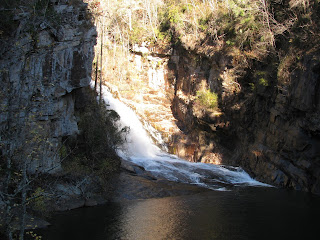
Next stop on today's itinerary is a hike to Raven Cliff and the waterfall that cuts through it. The hike begins at a pretty standard trail head and thanks to my National Parks Pass, I can avoid paying the parking fee. Departing the gravel entrance road, the trail immediately enters a beautifully wooded area and follows Dodd Creek.
The trail is well worn and leaves little doubt of the route. There is a little up and down and a couple of log bridges, one over the main creek and a couple of side streams feeding it. All in all though, it's a really easy hike and I'm able to get into a good pace of nearly four miles an hour. My pace does tend to get interrupted often though by the beauty of this area. In addition to Raven Cliff Falls, which is the main attraction, there are a number of other waterfalls along this creek, some of them being pretty spectacular.
The water of the creek itself is beautifully clear. I was just commenting last week about how the waters of the Chattahoochee River are so muddy in comparison to the waterways I've become accustomed to while living in the Sierra Nevada. This stream, though, is much closer to the crystal clear waters I'm used to and I love it.
It seems quite a few others had similar ideas about hiking this trail today as it is somewhat busy, but I would guess it gets even busier on a normal weekend. It's probably good that I decided to hike this trail today.
Finally arriving at the end of the trail, Raven Cliff, a fractured piece of granite rises a couple of hundred feet above me and the namesake waterfall has hollowed out a path through the fracture. It's actually quite stunning. A series of cascading falls bring the water down to a more level area where the crowds are, but I, of course, have to do a little climbing to get a better view of the labors of the falling water. It's a stunning feature and while I can only see hints of the water above the cliff and through the fissure, I can see how deep the water has carved into the fault in the granite; enough to form a large pool within the mass of stone. It's breathtaking.
After spending a few minutes, I head back the way I came and return to the parking lot a short time later. The return trip was uneventful, but I was able to get in an additional 5.5 miles on this trail today. I must say that this is probably my favorite hike since arriving in Georgia.
Since the big family get together for Thanksgiving isn't until Saturday, I thought I would take the morning and afternoon to do some more exploring of the areas around my new home. In talking to a lot of my new acquaintances, a state park called Tallulah Gorge seems to be a favorite spot for hiking and adventure. I figured I would start the day there.
About an hour north, I arrived at the park entrance and as I had hoped, the holiday is seeing most people staying at home, leaving the park and trails to me and just a few others. I recently purchased a Georgia State Parks Pass, which gives me free access to all of this state's treasures. I'm pretty confident it will pay for itself.
The trails start just behind the visitor center and overlook a tall, thousand foot gorge cut by the Tallulah River and extending approximately two miles through the dense quartzite stone. As the river traverses that distance it drops nearly five hundred feet over six waterfalls. These waterfalls are the real source of the attraction of this place. For the most part, the trail itself is carpeted with that recycled tire material making it a party on my feet. It actually feels really good to walk on this bouncy stuff.

As I hike the overlook trail, I'm granted nice views of three of the falls. I want a bit more though and so, I climb down a series of 300+ steps to the a suspension bridge that crosses the gorge and then another 200+ steps to arrive at the river. A popular adventure has visitors rock hopping and wading through the shallow river and making their way down the gorge. I think I would enjoy doing this, but perhaps when the water is a bit warmer . . . not late November. Also, it requires a permit, which are issued in limited numbers on a daily basis and they aren't issuing them today, likely due to the slippery conditions caused by the rains that passed through yesterday.
After spending a bit of time admiring Hurricane Falls, the largest of the six, from the bottom of the gorge, I decide to climb back up. I'm in pretty good shape, but 500+ steps uphill do get me a little winded. After arriving back a the top, I finish out the overlook trail, which takes me to a view of the Tallulah Dam upstream from the falls. I understand and support the need for hydroelectric power, but it's always a shame to see such things spoil the natural wonders.
Having finished this adventure for the day, I head back to my jeep and set off for my next stop. I got in right at 1.7 miles here at Tallulah Gorge, but with all of the steps, my legs think is was much more.
The Chattahoochee River snakes through the greater Atlanta area and offers a number of terrific trails and water sport options for the so inclined. I set out with a meetup group this morning to explore one of those trails. The Jones Bridge Trail follows a section of the river with in the namesake national recreation area and in the past offered views of the ruins of old wooden bridge that used to allow passage across the river, but talking to some of the other members of the group, it sounds as though the ruin was disassembled and removed at some point in the last couple of years. Oh well, its still a great day for a hike in the woods.
Meeting up with the large group at the parking lot pay station, we do a quick round of introductions and then hit the trail. Late in the fall, which we are now moving into, most of the autumn colors have fallen from the trees and now carpet the ground. It's less pretty, but still nice to be outside. The trails seem to zigzag through the woods, following the river at points, and going a slightly further inland at others.
Along the way, I make a couple of new friends and enjoy conversation with my fellow hikers. As we reach the turn-around point, we stop for a few minutes to rest and enjoy a terrific view of the Chattahoochee. I note how muddy the water looks compared to the crystal clear streams of the Sierras. This is much more like the waterways I grew up with near St. Louis. It's not better or worse, but just different than what I have become accustomed to of the last several years.
After putting in just over 6.5 miles, we end up back where we started. The group says their goodbyes and we go our separate ways. This trail was a fine Sunday afternoon, but didn't really offer much in the way of memorable scenery.
Today, I went out for my first hike with a local meetup group. I made some great friends and got in a lot of terrific trail miles with one of the groups back in Reno and I thought this would be the best way to learn of and explore some new trails in my new home. Meeting at the Cochran Mill Park entrance just before noon, the dozen or so members of this little expedition made quick introductions and swiftly departed into the autumn woods.
As we hiked through the naked trees, now nearly stripped of their summer foliage, I made my way towards the leader and started a nice conversation. She works for one of the airlines and is originally from the Channel Islands just off the coast of Normandy. We discussed our travels, this hike, other hikes in the area and a plethora of other topics, while made a good pace through the leaves on this well worn trail. I commented about how much I appreciated the pace she was driving, as it was just about right for me.
The woods here is unremarkable, but does remind me a great deal of the summers I spent on my paternal grandparents farm in western Kentucky. It somehow feels like home. Overall, the trail is well maintained and there is very little in the way of elevation gain or loss. I do note, however, that it seems to excessively twist and turn as it makes its way through this wooded area. I don't mind the miles, but at times, it almost seems as though the trail was cut this way for no other reason than to make it longer. That seems oddly unnecessary to me, but I'm here and so, I'll enjoy it.

A short distance below us, a small creek comes into view and the leader mentions that we will soon be crossing over this area. We take a side trail that signs indicate leads to a waterfall. From here, we reach a small waterfall that we decide to cross above. The water is not deep and the fall is only ten or twelve feet, but with a large group, some of which are inexperienced, we begin looking for the best place to cross. A couple of younger guys, just getting a running start and leap across the flowing water. Trying to find a safer path for the group, I make way down the stream slightly and find a spot to cross over the aging granite where the water is no more than a half-a-foot deep. My shoes get wet, but no matter. When I return to the group, most have found their own way across and we start heading back towards the cars on a new trail.
When we crossed the creek, we switched from being on the yellow trail to what the park map designates as the red trail. It's similarly wooded, but perhaps a bit more hilly. As I had stopped to grab a snack, I now end up towards the back of the group and make some new friends. Again, the people I'm with are friendly and we have some wonderful discussions about all sorts of things as we make our miles.

Finally, arriving at a larger section of the main creek, we encounter a larger waterfall with the ruins of what was likely a grist mill at some point in the past. All that remains now are a few crumbling stone walls. I suspect I will be a seeing a lot of sites like this as I continue to explore the areas around my new home. After we cross a sturdy bridge over the flowing creek, we are back at the parking lot. The group says some quick goodbyes and then head to their respective cars. We got in about 11.8 miles today, which is really nice, as it is the longest hike I've done in a couple of months. I may feel it a bit tomorrow though; we'll see.
One thing I missed during the many years living at the eastern foot of the Sierra Nevada Range was the autumn colors. There aren't a lot of deciduous trees in that part of the country and so, the spectacular palates I was used to growing up in the Midwest were not something I was treated to while living there. Now that I'm back east, it's time to revisit some of those vivid memories of my childhood. Learning of a publicly accessible, but privately owned Japanese garden a few miles north of Atlanta, I thought it might be the perfect site for this tour down memory lane.
Gibbs Gardens was created by the retired owner of the largest landscaping companies in Georgia, who wanted to share his love of horticulture with the community. After finding an appropriate site, he began work on the 260 acre garden in 1980 and finally opened the garden to the public just a few years ago. It consists of his home, atop seven ridges, and two other featured gardens, the Waterlily Garden and Japanese Garden. My focus for today's stroll would be the later, to enjoy the marvelous colors of the changing leaves on the Japanese maple trees.
After a short orientation by an incredibly friendly staff-member, I began my walk through the manicured gardens. Beset by man-made ponds and a natural waterways, the entire landscape is breathtaking. A large pavilion area complete with stage and seating is home to summer concerts, while a truck-pulled tram takes those less-capable of walking through the facility for a ride.
Upon passing through a Shinto arch, designating the beginning of the Japanese section, the colors really begin to pop. A number of Buddhist statues and other Zen artworks have been carefully placed among natural settings to give the area the right cultural feel; not gaudy, but just right. The walkway winds around a number of water features, many of which are flanked with the colorful shrubbery or trees, lending that burnt umber color scheme we are so accustomed to this time of the year. It really does bring back some memories.
I spend an hour or so leisurely wandering the well-maintained paths of the garden before heading to a small cafe inside the grounds for a light lunch. It's been a wonderful experience and this is a place I would enjoy returning to during another season to see who the cycles of time alter the rich color schemes.
A few miles east of downtown Atlanta, a large granite dome erupts from the green hillsides. It seems incredibly out of place in this area and more appropriate to my former home in the Sierras. With that said though, it seemed like a great destination to explore this morning. After researching the site, I learn that it has been turned into something of an amusement park Lets see what this is all about. As I pull through the gate and pay my admission fee, I start looking for a parking lot for the Cherokee Trail, which circles the natural monument. After parking my jeep, I head across the street and quickly enter the woods.
The trail is well worn, but not overly developed. It's a bit on the cold this morning, which may be deterring the masses from joining me on the trail, but that's just fine with me. I prefer the solitude sometimes. The woods itself reminds me very much of those I used to explore as a young boy on my grandparents' farm in western Kentucky. I'm also reminded of Robert Frost's famous poem, the Road Not Taken. The fall foliage here is very much the yellow wood of his verse.
Along the way, the trees occasionally part ways and open up to a granite slope, which again reminds me of hiking near Reno, but here the deciduous trees reign supreme instead of the conifers that I've been so used to for the last several years. It's a nice change. The trail also runs parallel to an old railroad track, which adds character.
I see a few other hikers and trail-runners along the way, but it's not very crowded at all. I also note that I am more at ease here than I would be hiking in the Sierras. Not that I was ever afraid to hike, but I was normally very hyper-aware of tracks and other signs of predators back there, and while the same fauna live here (though in lesser numbers), I somehow feel less on edge being out in the forest. It's difficult to explain and not necessarily a good or bad thing, but just a difference that I'm becoming aware of.

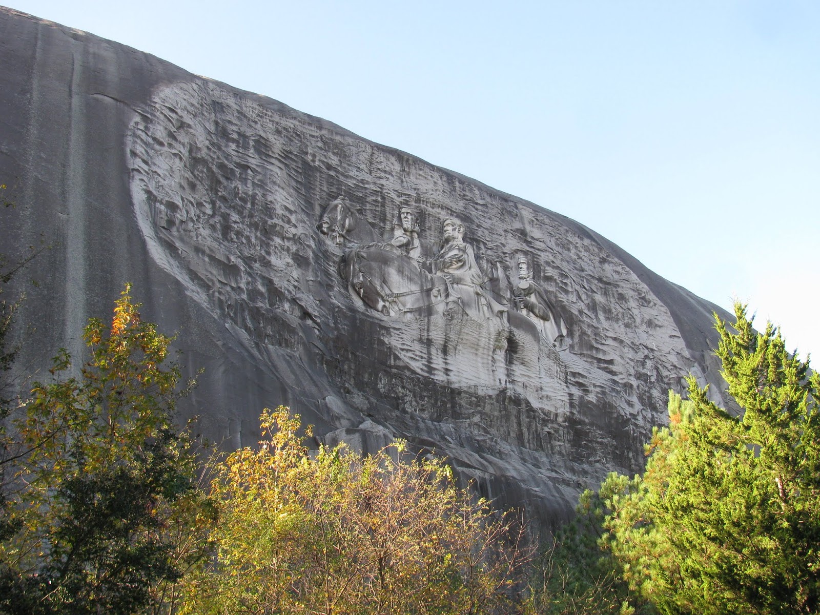
The trail opens up into a large developed plaza known as the memorial lawn. I must assume that festivals and concerts are held here, given the seating and overall shape of the area. Most prominent though is a gigantic carving on the side of the mountain. The stylized images of Jefferson Davis, Robert E. Lee, and "Stonewall" Jackson adorn a huge panel hewn from the granite. While I certainly don't celebrate these mean or what they stood for, they are thought of by many as heroes of the Confederacy that lead to the American Civil War. To me, however, they were rebels on the wrong side of a just cause and what they fought for was despicable and tarnishes any glimmer of goodness in the human race. I don't celebrate the men, but I can recognize the artistry and grandeur of the panel holding their images.
Continuing around the granite behemoth, the trail begins to run parallel to small creek. The water is surprisingly clear and as I walk, I note a small bridge leading to a "nature garden". The garden is really nothing more than a circle of stone blocks, each engraved with a woman's name who was a member of one of the organizations that helped develop this park. It's a nice touch.
The trail is pretty well marked all along the way, but I eventually reach a point at the far end from where I started, where I get a little confused. A number of group picnic structures have been built in and around the area, but I eventually find my way and then suddenly come up on a bridge and antique grist mill. The signs indicate that the mill was relocated here in the 1960's, after serving a nearby community for nearly a century. It's a rich piece of history that adds to the character of the trail
From here, the path is right alongside the shoreline of Stone Mountain Lake; literally right beside the water. A covered bridge leading to small island catches my attention and it again was relocated here to add to the character. After crossing a land bridge across the lake, the trail follows the opposing shoreline and opens up to amazing views of the autumn colors below the white granite dome erupting from the earth.
The final half-mile or so of the trail traverses a long granite slope, which would normally be no problem for the Merrell shoes I'm wearing, which I bought specifically for walking on granite slabs, but the morning dew is dripping off the trees and creating hundreds of slicks along the granite that I must cross to return to the jeep. I carefully make my way across and finally reach the parking lot. This has been a pretty interesting hike and I logged about 6.1 miles along the way. This really was a nice hike and I'm really glad I did this one.
Continuing my adventures in my new home, I decided to multi-task a bit. I headed over to Athens, GA, a few miles east of my new home in order to visit one of the favorite local breweries, Creature Comforts. While in the area and waiting for the brewery to open, I wanted to get a few trail miles in and opted to visit the Georgia State Botanical Gardens. After grabbing a trail map from the visitors center, I decided to hike the White Trail, which was the longest one available.
The trail supposedly departs the visitors center and pass through a kids play area before entering the woods. Unfortunately, it is very poorly marked and I spent a few minutes trying to find my way. Eventually, I found a well worn path through the woods and started the hike. The weather is just about perfect and I enjoy the wooded area, which reminds me a lot of the areas I grew up in near St. Louis and my families summer visits to see my grandparents in rural western Kentucky.
The trail follows the shoreline of the Middle Oconee River for a long while. It's pretty, but I can't help by compare to my adventures out west. I'm sure there are much prettier areas that I will visit in the near future and so, I'll just take solace in getting some trail miles in today.
A few twists and turns, some small hills, and a couple of foot-bridge crossings over small streams finds me back at the jeep. I managed to get in just shy of 4 miles today. Now its time to enjoy some tasty brews.
After living in Reno, NV for the last seventeen years, it was finally time to move on to some new adventures. I'll miss the Tahoe and the Sierras, but staying in one place for too long leads to stagnation and I can always travel back to see friends. After spending most of October preparing for the move, my wife and I finally arrived in Atlanta, GA. I'm not sure there is a environmental equivalent of culture-shock, but it's definitely a big change. Not wanting to wait to get outdoors, I ventured out a bit as soon as we established ourselves in our new house.
My first stop was the Etowah Indian Mounds about an hour west of my new home in Lawrenceville. These earthen mounds were at the center of a small Native American city that flourished during the Mississippian culture between 950 and 1400 C.E. It is related to and reminiscent of the much larger city of Cahokia near my birthplace, but on a small scale. Only three mounds remain at this site.

As I enter the small visitors center, the lone park ranger is giving a short talk about the history of the site to a boy scout group. I stand at the back and listen in, and then when he finishes, I check in and begin exploring the site. From the visitors center, a path leads out into an open field, which once served as a courtyard below the tallest of the three mounds. I first walk over to and up the stairs of the smaller two mounds. Just to the southeast of the mounds, the Etowah River swiftly flows past and probably served multiple purposes for the civilization that once thrived here. Finally, I make my way up the largest of the mounds, which is believed to have served as home to the leader or chief of the city. From the top, I can see far off into the distance, even through the dense fog that is coming off of the river.

After climbing down the dew-laden steps of the main mound, I head back to my jeep. For the first stop of my new adventures, this was a decent choice. Not a lot of hiking involved, but certainly some very rich history.