Two of the other stops I made in Death Valley were all about spectacular views. The first, Zabriskie Point is also on the west side of the park a few miles past Furnace Creek on highway 190. A large parking lot sits below a well worn climb up to the vista point. Judging from the crowd here, this is obviously a very popular point and as I begin to climb up the short trail to the top, I can see why.
Below Zabriskie Point expands a landscape of multiple shapes, colors, and textures. As I understand it, this is the eroded remains of the ancient Furnace Creek Lake. The dry landscape and plethora of minerals in the soil here makes for some magnificent contrasts. The view from this point is ideal to see this amazing sprawl. And while my current trip won't allow me the time to explore it, there is a trail leading through these badlands. I will definitely have to hike this on my next trip.
Further down highway 190 is the turn off leading toward Dante's View. A posted signs warns against trying to pull a trailer up to this amazing view, which supposedly allows one to see the lowest point in North America, Badwater Basin (at 282 feet below seal level) and the highest point in the contiguous United States, Mt. Whitney (at 14,505 feet) all in one breathtaking scene.

After reaching the parking lot at the top of Dante's View, I can understand why no trailers should be pulled up here. Most of the drive is pretty easy, but the last half-mile or so is full of sharp, steep bends as the road winds around a small peak to get to the top. The view from up here is truly amazing, and possibly offers the best panoramic possible of the whole of Death Valley. Badwater Basin is fairly obvious in the foreground a few thousand feet below, but Mt. Whitney requires a bit more work to find. The range directly to the west of Death Valley is the Panamint Range, and while very scenic and even snow-covered does not reach the heights of the Sierra Nevada Range further to the west. However, if you follow the ridgeline with your eyes on a clear day (like today), you will eventually see distant snow-covered peaks above the Panamint range. I'm told this is Mt. Whitney, which lies about 85 miles to the northwest (though at this distance and from this angle, I can't confirm that myself). Amazing!

I take a quick hike out to another connected peak where enthusiasts are taking pictures of the length of the massive valley below, and then return to my jeep for the drive down.
Winter in Reno, where I have lived for several years, is normally a time of few hikes and outdoor adventures due to most of the mountain passes being closed off. One destination that is an exception to this thinking is Death Valley. In fact, visiting this park in winter is the ideal season due to the incredibly high summer temperatures (exceeding 125 degrees at times). A gentlemen that I work with at my new job has spent a great deal of time in Death Valley over the years and suggested a couple of points of interest that I have not visited on my previous trips to the park.


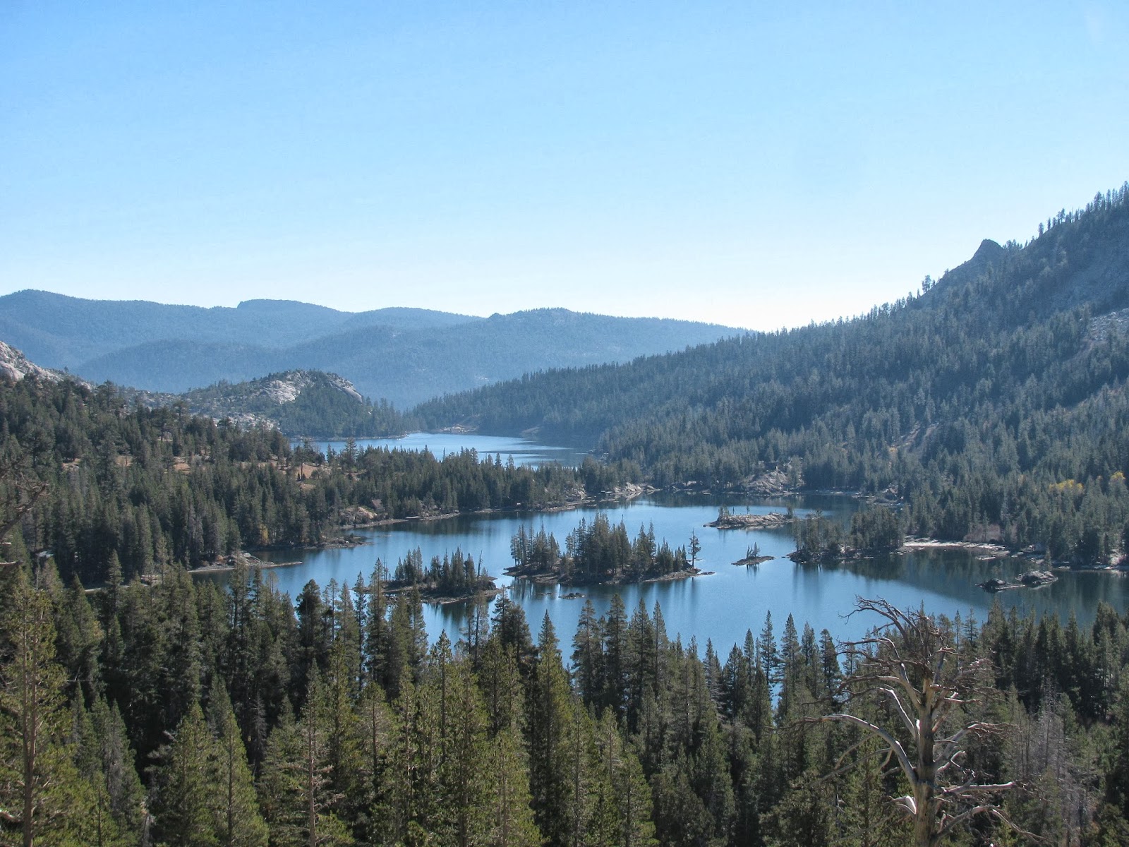
The first of these was Titus Canyon, which I had always been curious about. The exit of the canyon is well signed driving from Scotty's Castle to Furnace Creek, but prior to planning this trip, I had not looked into where the canyon drive started. In fact, it begins outside of the park near the town of Beatty, NV. From Beatty, head east on hightway 374. After about five miles you will pass a right turn that leads to the ghost town of Rhyolite, and another three or so miles past this turn, you will encounter another turn of listed as Titus Canyon. The sign recommends a high clearance 4x4 for this road and I would agree with the assessment, as it is rocky, windy, and steep in some areas. It is also one way, heading west, into the park. The first several miles are relatively tame (though there are some sharp and steep turns) as you cross a small mountain range before entering Titus Canyon itself.

Once inside the canyon, you will drive down a wash, which presumably carved the canyon over the millenia, that has been somewhat leveled to serve as a loose gravel road. Passing through the narrow canyon, you will be in awe of the shear cliffs on either side. I wish it had been a bit warmer so I could have taken the top down on my jeep, but the sunlight in this narrow winding pass keeps the temperature pretty cool. No worries though, I only saw one other vehicle during the entire 27 mile drive and so, was able to take ample opportunities to get out of the vehicle and get some pictures. As the drive itself was pretty breathtaking, I decided to attempt to film some of it as well using the video feature on my camera.
I was also suprised to see a small petroglyph site about midway through the canyon. A sign on the right side of the road asks visitors to preserve the site. A bit further, and nearing the end of the canyon, it gets more narrow as it winds to and fro through the cliffsides. Finally, it releases the traveler to a gated parking lot where hikers can begin the trail through the canyon on foot.
This was a specacular drive and while not overly rough for my jeep, I'm reminded of how much I love rubicon. I would strongly recommend this drive to anyone with the appropriate vehicle. It's definitely worth it.
With winter quickly approaching and most of the high passes already closed due to snow, I've been searching for more and more local hikes that remain at low enough elevations as to allow me to do them through the winter. I have hiked a number of them around town, but doing the same trail multiple times a week can get boring quickly. All that said, I came across a write up online about the Ophir Creek Trail, which seemed to fit the bill, at least a portion of the trail.

The trail starts at the Davis Creek Regional Park, which is just a few miles south of Reno on old US 395. A quick trek through some lush forest terrain leads across the first of several creek crossings. This one offers a small bridge, but that will be the last of those facilities along the way. I've not done a great deal of hiking in the area at this time of year, but the orange pine needle carpet and the occasional pine cone makes a nice contrast against the green of trees and the white granite boulders scattered around the landscape.

The next creek crossing (I believe this one is actually Ophir Creek) is a matter of rock hopping while crossing a series of stream fingers. It makes for a beautiful site. The trail is pretty well maintained and marked, though there are a few branching trails that require me to pay some attention to where I'm going. At point along the way, I'm offered a terrific view of the washed out canyon cut by yet another creek. This trail winds it's way up the hillsides adjacent to Slide Mountain, the home of the Reno's premier ski resort. Slide Mountain was presumably named due to it's proneness for periodic and often devestating landslides on it's southeast face. It appears to me that some of the devestation visible in this canyon was probably caused by the last landslide, which occured in 1983.


Up until this point, this trail has been a pretty relentless ascent up this mountainside, but this next section flattens out a bit. Here the ground below my feet is composed mostly of pulverized granite and a few oddly shaped granite tours sprout out of the eary. One formation, made of two large monoliths, reminds me of Laurel and Hardy.
Another much larger one on the opposite side of the trail has a large irregularly shaped boulder balanced atop a granite pyramid. This area reminds me of my beloved Yosemite. My time in this area is shortlive though as I continue on. Just after this section, the trail shares it's path with a off-road trail, which I later discover leads to a small lake within the canyon below. Luckily, I come upon a sign indicating that my trail continues abruptly uphill, while the road continues on to the lake. I opt to take the more difficult uphill path.
This section of the trail, steep as it is, seems to be less trafficed than what I have traveled on thus far. It winds through some dense shrubs and cross more trickling streams, including a moss-covered waterfall that must be crossed. This one reminds me of my time in Scotland.
I wonder how much further it is before I reach my destination at Tahoe Meadows. The steepness continues as I pass through another lush meadow, but this time ripe with fall colors and a young aspen grove stripped of it's fall leaves by the strong winds at this altitude. There is also some snow up here, though it has melted and refrozen into small patches of ice. At one point, though I'm being cautious, I slip and fall on my arse. Only my pride was injured, luckily.

A little further and I finally reach my declared turning point, the intersection with the Tahoe Rim Trail in the forest around Tahoe Meadows. I do an about face and begin the return trip. I'm hoping this will be a little easier, as it should be as much downhill now as there was unshaking uphill on the way up. It turns out to be fairly easy traversing the return route, but I didn't remember it being quite so steep. About halfway back, the impact of each step starts killing my knees. I try to slow down a bit, which seems to help.
Eventually, I reach the parking lot where I left my jeep this morning. In total, this was a nearly 16 mile trek with nearly 4,000 feet of elevation gain. That's very steep for an out and back hike, but it was great exercise. I hope I feel the same way tomorrow.
On a windswept hill overlooking Virgina City, timeless reminders of this areas prominent days can be found. In 1859, the first major silver deposit in the United States, the Comstock Lode, was found here. As many a man came here to make seek his fortune in the silver mines, Virginia City quickly exploded into the queen of the boom towns, swelling to a population around 15,000 in the late nineteenth century.
As I wander amounst the terraced graves of those laid to rest here, I'm intrigued by many of the burial practices of the time. The majority of the graves are surrounded by ornate fencing of wood or wrought iron. This was apparently a common practice during the Victorian Age. Also, a number of the tombstones are carved from wood. As you can imagine, 120+ years has made much of the text unreadable.
It's also interesting to me that the cemetery is sectioned off by relgious sect with the Mason's claiming the largest area. There are sections for the Hebrews, Roman Catholics, and many others strewn about these hillsides. And also of note, few those laid to rest here were native Nevadans. In fact, I'm fascinated by the number of markers indicating natives of Ireland.
All in all, there are a probably a couple of thousand graves here, and nearly all of the markers, fencing, and other ornatmentation are in disrepair. It is humbling though to think of these pioneers and the fortunes they claimed from the earth below us. Now though, they are simply dust in the wind, as we are all destined to become.
While I have visited this amazing petroglyph site before several years ago, that trip was via 4x4. I recently joined the Reno Hiking Meet-up group and received an email stating the group would be hiking to this desert site. I have often considered returning and this seemed like an excellent opportunity both to revisit the site as well as take my first trip with the group. Arriving at the agreed upon location, we car pooled to the trial head deep in the Lockwood area and started our trek. From what I understand from the organizer today's group is uncommonly large (24 hikers), but each and everyone of them were incredibly welcoming.

The trail starts up the bed of Long Valley Creek and follows it for about five miles. While the group attempted to follow a uniform and established route, it was often a matter of path finding as we zig-zagged back and forth across the creek looking for firm footing. I have to say that it was actually pretty refreshing to not have a well defined route. I was also surprised to find water in the creek this time of year after such a dry summer. I was informed that the creek is fed by a number of springs. Obviously, the local wild mustangs are aware of this as we encountered several of them along the journey.


I'm always amazed at how docile mustangs are. While they are feral, they generally encounter humans enough to not be terribly skittish around us. They are out here just trying to scrap a living off of the land, just as we would do. Unfortunately and as witnessed by the many carcasses we stumble across on the trail, this sometimes proves futile. The desert just isn't a hospitable place during these years of drought.
The group seems to be progressing pretty well, though there are definitely different levels of experience, as many of us push the pace to a point where the group fragments. The organizer, Mel, does a great job of trying to keep track of everyone and ensure no one gets lost. As we cross the creek at an especially problematic section, one of the ladies with the group looses her grip on the stone steps and falls into the mucky water. Two other gentlemen and I do our best to help her out of the water. Luckily, only her pride was injured.
Mel tells us that we should be looking for a set of power lines and an abandoned red car, which are the prime indicators of the site's location. Seeing the power lines in the distance, those of us leading the pack realize we are close and begin looking for what remains of a old red junker (though it has faded from red to pink over the decades). At the site of it, we take a sharp left turn and begin making our way up a rough 4x4 road to the petroglyph site.

The site is much as I remember it. Isolated and home to the one of, if not the, largest collections of ancient Native American petroglyphs in the state. According to documentation I have seen, the site contains approximately 2200 designs, most of which date to around 10,000 years ago. As I always do when viewing petroglyphs, I can't help but wonder about the artists that created them. What were they thinking? Who were they? And, why did they need to leave their mark on the world? I suspect their reasoning is no different than our answers to those same questions. Still, seeing art created so long ago and by a people, we know next to nothing about is quite humbling.

I spend a few minutes scrambling over the talus boulders and taking pictures, eventually making my way to the top of the ridge. the plateau above the canyon is as barren as any I have every seen in the Nevada desert. Why was this spot so special for the ancient inhabitants. While it could have been the creek below, the much larger (though still small by my standards) Truckee river is only a few miles away. We may never know, but it certainly allows us to ponder time immortal.

Many of the slower hikers are just arriving, as a few of us finish our snacks and explorations. I relax for a bit and share tales of the trails I have traveled, until a couple of gents decide they are going to head back in advance of the group. As I have plans for this evening, I ask if they would mind giving me a ride back to my jeep, to which they generously agree. We double-time it back to the trailhead, stumbling and loosing the trail a few times along the way. Eventually, we arrive at the parking lot and the Kens take me back to my jeep. Overall, a very pleasant 11.5 mile hike and overall experience. It's wonderful that so many like-minded hikers have taken to organizing trips like this. I hope to do more trips with the group in the future..
I have not yet been to Hawaii (it's on my list), but I have to imagine it is more lush and inviting than the lake in Desolation Wilderness named in the spirit of the Hawaiians. For a couple of weeks, I have been hoping to complete this hike, but the weather has not been kind. The Sierra Nevadas have received a combination of rain and snow the last two weekends. Today though, the skies were clear and presented a marvelous day to hike into the wild country southwest of Lake Tahoe.
The trailhead was a bit difficult to find, but after talking to a couple of friendly people, I finally found it at the foot of Lower Echo Lake. While this large body of water is extremely beautiful, it somewhat spoiled by the presence of cabins all along its shoreline. I guess if we coudl afford it, my wife and I might buy a cabin up here as well. For now though, I will have to settle for simply hiking through.
The trail is somewhat rugged and is comprised mostly of small granite rocks, with an occasional patch of dirt. While the trail is mostly level it does make a slow ascent up into the mountainous areas of the wilderness. Passing Lower Echo Lake, it's companion, the smaller Upper Echo Lake comes into view. similar in shape, but only about half the size, this lake has much less development around it. The lower lake only has boat access to the cabins and with the upper lake being slightly more remote, it makes sense that fewer people would have built here.
Finally, as I make my way around the upper lake, I pass a sign indicating that I have entered the Desolation Wilderness. Thankfully, this areas federal designation as a wilderness area prevents any development beyond this boundry. It's all wilderness from here on out. The trail continues through a wooded area that has a wonderful autumn display of colors in progress. The combination of desiduious and evergreens makes for a wonderful palate of rich colors. Passing a sign indicating which trail leads where, I elect to take a detour to the Lake of the Woods. From an article I read about this hike, this alternate route will be well worth it.

Heading down a number of swichbacks, I make my way down into a small valley to what is perhaps the most beautiful alpine lake I have seen. Lake of the Woods is a peaceful and serene jewel in this wilderness. Deep clear water gives a clear view of fallen trees and boulders on the bottom. There are even some tiny white sand (pulverized graine) beaches along this section of the lakes shoreline. I take numerous shots of this amazing place. If I were prepared to camp tonight, this would be where I would stay. As I prepare to leave a family of adolescent ducklings paddle across the calm water of the lake. Alas, it's time to move on.

Having rounded a good section of the little lake, I attempt to refind the trail, but fail to see any sign of human footfalls . . . awesome! Eventually, I decide to attempt a little trailblazing. I know that Lake Aloha is just above a rise to the Northwest and so I attempt to scramble over some boulders to get there. A small peak, which I have christened Road Block Peak, will have none of it. It prevents me from this path with tall granite boulders that I am ill-prepared to climb over. Eventually, I admit defeat to the tiny granite mount and double-back. I finally find the trail leading around the other side of the road block and make my way to Lake Aloha.

I'm suprised to see that Lake Aloha is actually a collection of interconnected pools covering an area the size of a couple of football fields. The pools are interrupted by the large granite islands throughout the area. I suspect that in the spring, when the snow has melted, the total area of the lake is much greater than it is this time of year. It is made obvious by the appearance of large patches of low earth, saturated with water, but lacking anything on the surface to be called a pool or lake. The fact that this "lake" exists in Desolation Wilderness is fitting, as this area has very little life. Tree's spotting the area and the islands dispersed throughout the lake are more often dead than alive, and from what I can see, the nearly clear water is free of any fish. I call this place lifeless, but that doesn't mean that it doesn't have a beauty of its own. It truly does and I wish I could spend more time here, but unfortunately, I need to get back.

I take a few minutes to eat a snack (cliff bar, almonds, and some beef jerky) and then start the long trail back to my jeep. Clocking in at just under 14 miles, this was a great hike. I hope to do it again when I can take advantage of warmer weather and take a dip in the lakes.
For a couple of weeks now, I have been hoping to hike up this scenic mountain that is often sited as having some of the best views of Lake Tahoe, but unfortunately, weather has not been kind. Last weekend, it rained in Reno, which meant snow in the mountains around Tahoe. Not being familiar at all with the trail, I was very hesitant to attempt the hike on fresh snow and so I put it off. And with that first snow, came the fear that the rest of my hiking adventures this year would be limited to the lower elevations.
As luck would have it though, it got warm enough through the week to melt of the vast majority of the snow that fell. And so, I set out early this morning to conquer another peak. The trail to Mount Tallac starts between Camp Richardson and Emerald Bay, on the southwestern section of Lake Tahoe. The trailhead is well marked and simple to find. At the parking lot, I registered for a free wilderness permit, as instructed by the signage. The trail enters the federally protected Desolation Wilderness area very quickly after leaving the trailhead.
The trail almost immediately encounters the small Floating Island Lake on its west side, and shortly thereafter, the much larger Fallen Leaf Lake. In fact, much of the trail in this section travels along a ridge overlooking this large lake.
A little further on, we take an abrupt turn at the tiny Cathedral Lake, which is quite serene. From this point on, the elevation increases much faster. This should have been obvious to me, knowing the trail gained 3500' over a short five miles, and seeing Tallac looming above the trail through this section. Onward and upward, I go.
It's a brisk fall morning here in the South Lake Tahoe area, and the weather report predicts a storm this evening, which explains the overbearing wind blowing through the forest. I suspect it will get much stronger as I continue to gain elevation. As I'm starting to get a little cold, I throw on gloves, a stocking cap, and my wind breaker.
Continuing on up the very steep trail comprised mostly of loose gravel, the wind continues to get stronger. Eventually, I reach a bend in the trail where the grade starts to level out and I enter the a lush (or at least it probably was a few weeks ago) meadow overlooking some more lakes and mountains in the distance, all part of the Desolation Wilderness. While the trail is a bit easier in this section, the wind has not subsided at all. In fact, I think it is a bit stronger. I'm thankful for the occasional tree to help break it a bit.
Above me, I can see the trail will again enter another section of steep grade through some sharp rocks, as it approaches the summit. I push hard through this section in order to get through it. Reaching a ledge overlooking Tahoe, the trail itself pretty much dissipates and I'm left to scramble up and across some sharp rocks a few dozen yards to reach the peak.
Standing on the very top of Mt. Tallac, I can say the reports of the view were not false. This is by far the most majestic view I have encountered of the vast alpine lake below. However, standing at full height up here is all but impossible, as the wind is gusting to what has to be 80mph or more. If not for locking myself against some of the rocks, it would likely be enough to blow me over.
At 9739 feet, Mount Tallac is not even in the top ten as far as the tallest peaks around Tahoe, but it still made for a great hike. And while the final elevation isn't that high, getting there was something else. This is one of the steepest trails I have ever hiked, but it was well worth it in the end.
With my leg still a little sore from overdoing it a bit last weekend, I've spent the week doing some very short hikes and avoiding any strain on it. With the weekend here, I decided to keep at this pace and give my leg another few days without any major stress. With that said, I have been wanting to return to a well known petroglyph site about an hour from Reno called Grimes Point.

As the glaciers receded at the end of the last ice age, they left a large lake in the northwestern corner of Nevada, remnants of which can be seen in today's Pyramid and Walker Lakes. The ancient Native Americans hunted and foraged around the shores of this ever-shrinking lake. Between eight and two thousand years ago, they carved and scratched meaningful symbols into the rocks around Grimes Point, which would have been a peninsula jutting into the lake. In addition, they utilized many of the rock overhangs and caves in the nearby hills as shelter and food caches. The largest and most archaeological significant of these caves is known as Hidden Cave and has been excavated several times in the last century, revealing many details about the lives of these ancient peoples. This cave is left under lock and key, but as luck would have it, the Churchill County Museum offers guided tours on the second and forth Saturday of each month.

While I had originally, only been concerned with the petroglyphs at Grimes Point, I thought it might be worthwhile to visit the cave since I happened to be going on the day of the guided tour. After following a caravan to the cave trail parking lot, we hiked up the desert hillsides and around what was once the shore of the ancient lake until we reached the sealed entrance to the cave. That's when the whole affair went a little sour. After spending a good 20 minutes attempting to unlock the door, the guide gave up. Apparently, the desert sands had worked their way into the lock and mixed with oil sprayed into the lock by previous guides to seize it to a state of being unable to turn. I can't blame the tour guide. He gave it his all, but it just wasn't meant to be. He called the museum for guidance, but I decided to say my farewells and head back to the petroglyphs, where were the reason I had come in the first place.
Walking the short trail in and amongst the rock art, it's fairly easy to imagine ancient hunters laying wait among the ancient foliage for a deer or big horn to come to the shoreline for a water break. Perhaps the scratching on the rock, were just boredom while they awaited prey. There doesn't seem to be much of a pattern to the way the glyphs are arranged and it is extremely easy to miss them here. This is partly because they might appear any side of given rock and partly due to the faded nature of them on dark stone, which is made especially hard to see when the sun glares off just right.
After a short time walking in and around the area, I make my way back to where I had left the jeep. It's getting warm out and I need to get home, but it was a fun trip even without being able to enter the cave.