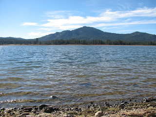
Smith Peak and Davis Lake (Plumas County, California)
Another day, another hike. This time, I joined the meetup group for a trip up Smith Peak overlooking Davis Lake, north of Portola, CA. Meeting the group just north of Reno, we carpooled up to the Davis Creek Recreational Area. Originally, we had intended to circumnavigate a large portion of the lake, but one of the hikers suggested hiking up to the fire tower on top of Smith Peak, which overlooks the lake. We all agreed and after arriving at a pull off area on the forest road, we hit the trail.
The trail itself is actually just a service road, which made for easy going. The incline was noticeable, but not overbearing. As we made our way up the mountain, I noticed some smoke rising from the hillside above us. I left the group to investigate and found a couple of smoldering piles of loose brush. I guessed that the forest service had been doing a small controlled burn in the area yesterday. With little to no risk of it flaming up and spreading, I returned to the trail and double-timed it to catch up to my group.
As usual, the group starts to fragment a bit as some of the faster hikers, including myself, break away from the group. It's not so much about racing up the hill as it is wanting to get a great workout in from the trip. No one seems to mind though and when we reach the top, we all take a few minutes to grab a snack and absorb some of the views. Unfortunately, the fire tower is locked and we are unable to walk around the balcony as I have been able to do at some locations.
To the east, we can take in the full measure of Davis Lake, though years of drought have affected the water level significantly. A view north, gives us a nice view of the snow-covered Lassen Peak. I suspect Mount Shasta would be visible from there too, but looking at the map, I think it is hidden behind Lassen from this angle. Finally, to the west, we are offered an outstanding view of the Sierra Buttes.
After a short time, we make our way back down the mountain, but as we had kept a really good pace both up and down the mountain, we decide that we aren't quite done for the day. After a hike just short of 9 miles to the fire tower, we decide to drive a short distance to the lake to explore the shoreline and visit a bald eagle nest that Deanna had discovered on a recent photography trip to the area.

The drive to the trail head is not much more than a mile and as we park and head across the road, we cross over Lake Davis Damn, which controls flow into the tiny thread of Big Grizzly Creek below. As we enter the pine needle carpeted floor of the forest, we struggle a little bit to find the trail, but eventually do and then start making our way around the fingers of the shrinking lake. In the distance, we can see the large eagle nest in the very top of the tallest tree on a small peninsula sticking out into the lake waters. We make our way around to the area below the nest, hoping to see the majestic residents. Once we arrive, we begin searching the skies and finally spot a pair of our national bird in the distance. They soar over us, most likely looking for food in the lake and forest below, but never actually land in their nest, though we wait for a good twenty minutes or so. As the eagles move onto better fishing grounds (with less spectators), we decide to head back to the cars.

Combing the long hike up to Smith Peak with this short trek around the lake, we put in about 10.4 miles today. Not bad. As we prepare to depart, we discuss the possibility of hiking a much longer hike around the lake in the near future . . . or perhaps a snowshoe adventure.


This is so cool. I love the pictures and commentary. Great job!
ReplyDelete