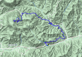
or a while now, the organizer of one the meetups that I frequently hike with has been talking to me about occasionally leading some more challenging hikes a bit further from Atlanta than the trails the group normally hikes. I appreciated his faith in me to lead hikes for his group and decided today would be the first outing. Not far from the Georgia-North Carolina border, Pinnacle Knob rises approximately 3,140 feet above sea level and towers over the nearby town of Clayton. We'll be hiking a section of the Bartram Trail to reach the summit.
Arriving well before the noon start time, I took the opportunity to scout out a report of a bridge wash out I had been made aware of. After hiking up the first section of the trail, I see what the report is talking about and while the creek is still crossable here, it will require jumping from and to some slipper rocks. Luckily, I see an alternative path that I'll talk to the group about when they arrive.
Returning to the parking area of the trail head, my first two hikers have arrived. I introduce myself while we wait for the others to join us. In total, six of us show up for the hike. There may have been more, but I made it very clear in my description that we would be departing promptly at noon and after a very quick round of introductions, we do just that. Additionally, I had set pace and elevation expectations with the group and let them know that if they were unable to keep up, they should either turn around and come back the way we came or wait for us to summit and return. Everyone agreed and actually thanked me.
Leaving the parking area, the trail follows a muddy path alongside some concrete trout beds constructed by the Civilian Corps many decades ago. While they have been in use for a long time and are now covered with moss, it still adds some interesting history to the area. From here, the trail follows some short switchbacks as we climb back up to Warwoman Road.
Crossing the road, we had up the trail on the right side of the creek, as opposed to the one on the left, which I had scouted previously. By going this way, we still get a great view of the first waterfall on the trail, but can avoid the somewhat sketchy crossing. From here, it's a long push up hill as the trail winds around the hillside. We gain and loose a little elevation as we go, but the predominate direction is up.
We drop down into another small hallow cut by Martin Creek and then cross a well constructed bridge just in time to see the second noteworthy waterfall. Both are flowing well today and we take a couple of minutes for pictures. Quickly though, we return to the trail. From here, it's mostly straight up.
Arriving at the top, three of us summit a few minutes before the others. I've been keeping an eye on everyone's progress and I know they are just now on the long switchbacks and will join us soon. We take a few minutes to enjoy the views from the top and a quick snack. Our remaining hikers summit just a few minutes afterwards and we all enjoy a few moments together. It's a bit brisk up here and there is one small patch of ice on the rocks we are sitting on, but after putting my puff jacket on, I don't even notice the cool breeze.
A short time later, the remaining two hikers find their way to the finish line and I congratulate them on their accomplishment. We hiked about 9.2 miles and with a net elevation gain of just under 1,700 feet. Discounting our break a the top, we were able to just barely exceed 2.5 mile per hour pace I had set as the expectation. The weather holding as it did for us and the marvelous waterfalls and view from the top, it turned out to be a great day. Everyone thanks me for organizing before we go our separate ways. I look forward to leading the next one.


No comments:
Post a Comment