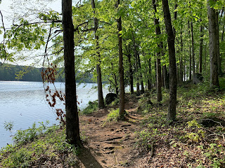
I had planned to hike Grandfather Mountain in North Carolina this weekend, but the weather forecast was calling for storms and given the rugged and treacherous nature of that trail, it didn't seem like a good idea to be up on the ladders and ridges during a storm or even after one. I still wanted to get some miles in though and decided to head over to nearby Fort Yargo State Park, which is only about twenty minutes from my home. I've hiked in this park with one of the Meetup groups a couple of times in the past and found it satisfying enough for another visit. As long as I get my miles in early, I should be well head of the storm.
After parking near the visitors center and getting my bearings a bit, I decided to hike the loop around the lake. At least right now, the weather is just about perfect, with sunny skies, moderate temperatures, and nice breeze blowing. I can already see a number of kayakers out on the lake. The hike starts just behind the visitors center with a little patio offering a view of the actual fort, for which the park and lake are named. Fort Yargo was built in 1793 as a defense against the Cherokee and Creek. On past visits, I have explored the area in around the fort itself and opt to just see it from a distance today.
Next, the trail follows a well-constructed and long walking bridge across one of the fingers of the lake. It's wide and allows for both foot traffic and bikes. The trail then leads into the wood with a couple of options. I decided to take the Rock Garden path, which follows the shoreline of the lake much more closely and includes some very basic rock scrambling. I think the other path runs parallel, but avoids the rocks. The two paths rejoin after only about a tenth of a mile.
From here, the trail follows fairly closely to the lake shore, darting in and out of the woods. The trail itself is maintained really, really well. I even encounter a young man with a leaf blower clearing the fallen leaves and pine needles from the soil. The one thing I do note though is an abundance of poison ivy lining the sides of the trail. It appears to be kept under control and off the actual pathway, but should you wander off the trail, be prepared for an itchy good time.
The trail then leaves the shoreline and heads a little deeper into the woods. It's still very easy and I pass a few other hikers and mountain bikers as I finish the last part of the loop. Arriving back a the visitors center, I check my app and see that my distance is almost exactly 6 miles. Not a bad day and with the beautiful weather, this was a great alternative to the long drive to North Carolina.


No comments:
Post a Comment