
The drive to the southern end of our trail takes about two and a half hours, and as I pull into the parking area at Foster Falls, see several people prepping their gear to do some climbing on the cliff walls below us, but no other backpackers. I always try to arrive early for events I'm leading and I assumed I had just beaten everyone else here. Sure enough, the others start to arrive in the minutes leading up to our scheduled departure time of 10:00 AM EDT, though we're actually in the Central Time Zone at this point. Those that show up all know each other and so introductions are not necessary. I hand out copies of my camping reservation for the others to place in the dash of their cars as a permit for overnight parking. When the start time arrives, we are still missing three people that have signed, none of which are known to any of us. I had made it clear in the description and in later comments that we would be leaving on time and so, we do our last minute gear checks and then the four of us hit the trail.

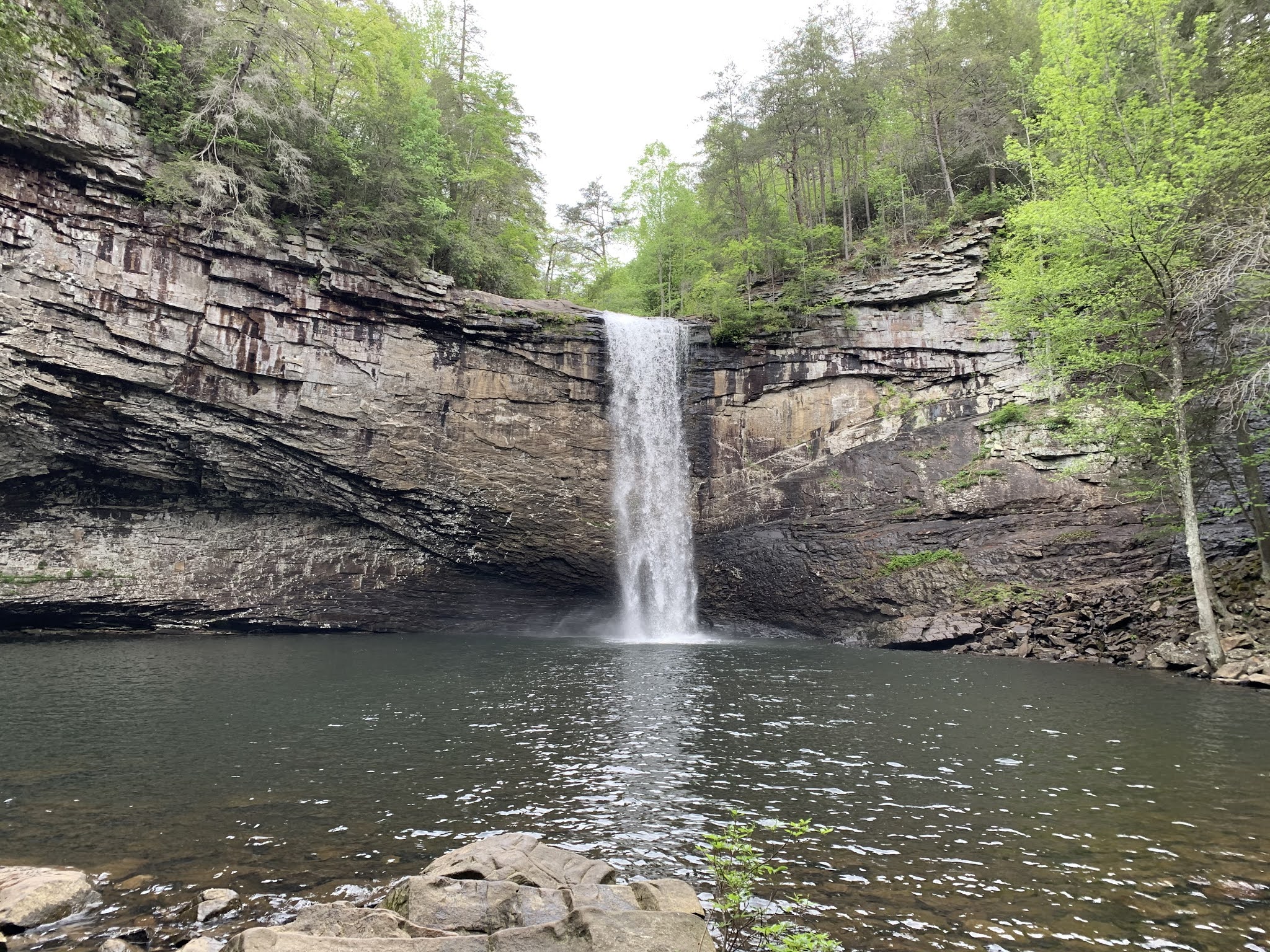
While not technically part of our planned trail, I offer the option for us to hike down to Foster Falls just below us, which is a spectacular waterfall and in my opinion, well worth the trip down. Everyone enthusiastically agrees. With our full packs on our back, we make our way down the rock hillside and across the wooden suspension bridge to the bottom of the waterfall, which drops some sixty feet over the side of a cliff into a large pool. I've visited before, but the others are in awe, as their first time seeing this masterpiece of nature. It certainly is a great way to start the trip and only added a mile or so to our our overall hike.
Before too long, we reach the first and worst of our dips into the canyon as we cross the Laurel Branch of Big Fiery Gizzard Creek. This section forces us to descend a very steep downhill across a boulder field strewn with loose soil. The proposition of this is made many times more challenging by the fact that our packs move our center of gravity slightly behind where we are used to having it. The four of us very carefully and slowly make our way over the rocks and down the hillside to the creek crossing. Here at the small wooden bridge, we encounter a young woman crossing the bridge in the opposite direction, carrying what appears to be a backpack and front pack which combined, probably outweigh her. At the bottom of her backpack, a large (probably four-person) tent hangs. As we warn her of the difficult climb she has ahead of her on this side of the creek, she sighs in exhaustion. She's obviously very fatigued from climbing down the far side and we encourage her to take a break before starting up what we have just come down. She sits on a rock and rests for a bit, while we cross the bridge and begin the ascent up the opposite side.

Now on top of the plateau, we have easy trails for the next couple of miles as we cross over to the cliffs above Big Fiery Gizzard Creek. A number of small feeder creeks cut through the area, but in most cases, small wooden bridges allow us to pass over them unmolested. When we reach the McAlloyd Branch, I note a dotted line representing our trail that appears to cut around the top of that small canyon and avoid the steep descent and ascent. I suggest this route to the others and we agree to try it, heavily prompted by the danger of our last drip into one of these side canyons.

Unfortunately, the trail represented by the dotted line either no longer exists or never did. Either way, we are left doing a little bushwhacking through the woods and later through a thorny meadow. I warn the group to be watch for for snakes as we pass near a small pond and later suggest that we do a tick check of each other to ensure none of the little bastards got onto us from the tall grasses. It takes a bit, but after crossing a boulder field covered in poison ivy, we rejoin the trail. We were confident in where we were and where we needed to go and so, we were never lost, but it just took us a while to find the trail again.
Just a bit further and we reach the junction with the Ravens Point spur, which we've planned to take our lunch at. Due to the very rocky terrain and our caution traversing it, we are a bit behind scheduled, but I think we could all benefit from a short break to refuel. Not to mention, the view from Ravens Point is suppose to be one of the best along the route.

It's about a half-mile detour each way, but a short while after the fork, we step out onto a nearly bare rocky overlook. The green canyon that is the Fiery Gizzard flows out in front of us as far as the eye can see. It's absolutely stunning and a great place to get some lunch and just reflect on how amazing it is to be out here. After about 20 minutes and taking advantage of the facili-trees, we head back to the main trail.
At this point, we have another couple of small creek crossings each punctuated by a beautiful waterfall. The first of which is steep embankment with a secondary cascade dropping fifty or more feet below us after sliding off of a slimy outcrop of rock. To get around this, the trail has been routed at the very top of the canyon and passes behind and under the waterfall. A sturdy chain has been been attached to the rocky face and provides a hand hold as each of makes our way under the cold flowing water in turn. While a few drops might have hit us, we remain mostly dry as the water descends a couple of feet further out than where the trail passes. It's actually a really, really cool part of this trip and a highlight for all of us.


A little further on and we being our final descent into the main canyon. This one is again pretty steep, but not nearly as treacherous as our earlier one at the Laurel Branch. Amazing rock formations jut up from the ground, or more accurately, remain after the ground has been carved away from them by eons of erosion. We note again that the time is slipping away from us due to the very rugged nature of the terrain and how slow we are forced to travel across it. I had anticipated this hike taking about six hours, but it's looking more like either or nine a this point. All of us are very fit hikers and capable of maintaining three to four miles per hour on good trails, but the nature of this surface, the repeated dips and rises, the instability of the rocks and soil beneath our feet all force us to a snails crawl over some sections.

After reaching the bottom of the canyon, we will follow Big Fiery Gizzard Creek for the next three or so miles, again having to drop down and climb back up short little pieces where the banks have washed out. It's truly beautiful country, some of the most breathtaking I've ever seen anywhere, but it's a hard hike.
Eventually reaching the bridge that we knew has been washed out last year, we begin combing the bank of the creek looking for the best place to cross. As we search for our best option, we find the pylons of an earlier bridge, which has also been destroyed. Just before leaving my house, I had reviewed another video of some hikers on this trip only a month ago and they found a sturdy log to cross on. That too has been washed away by the spring rains. The water is not deep, but the rocks in the creek bed are slimy and dangerous to cross on. Finally, I pick a spot begin rock hopping across, relying heavily on my trekking poles to take my weight as I'm much more confident in their ability to not slip on these rocks. I manage to get across with only partially submerging my right foot. The others follow roughly in my footsteps, but as the final two seem to be having major difficulties, I recommend just going all in. Much better to have wet feet and shoes than a busted cranium. I can just imagine one of them slipping on a moss-covered submerged rock and falling headfirst into one of these stones. They take my advice and soon we are all on the other side.
Deep in this canyon, the sun is starting to near the horizon and we know we need to make this final ascent in a timely manner, else we will be setting up our tents in the dark. The trail curls around and for the most part, gently climbs this last cliff side before reaching the top and civilization. A large parking area, complete with restrooms lay before us and we take advantage of it to rinse ourselves off. The humidity in the canyon was dreadful and any chance to clean up a bit was welcome. That said, the mosquitoes take note of a slightly cleaner me just as I walk out and immediately begin feasting on me. I brush them off and quickly spray myself down with a healthy dose of repellent.
Now the task is to find the campground. Luckily a sign directs in the correct direction. It's getting dark and our pace shows some urgency, but the mile markers seem to be off a bit and what is listed as 0.6 miles feels mile like 1.6 miles. Finally, we reach our campsites and quickly set up our tents. Mine goes up very quickly and I'm the first to begin fixing dinner. We had discussed getting a campfire going, but at this late hour and with everyone completely exhausted, we decide against it. Everyone in turn finalizes their sleeping arrangements and joins me around the fire-less fire pit as we each cook our respective meals. For me, it's pad thai, which I had forgotten included a number of additional add ins within the the pouch. Most dehydrated backpacker meals simply require one to add boiling water and wait a few minutes. This particular recipe also requires me to add peanut butter, chopped peanuts, lime zest powder, and cayenne pepper at various points along the waiting process. It pays off though and is quite delicious.

I only wake a couple of times through the night. The temperature was perfect for camping, only dropping into the mid-fifties overnight. At some point shortly before sunrise, I hear a rooster announcing the incoming new day, but I roll over and fall back asleep. Finally waking up around 6:15 AM, I check the weather report. I know there is a storm coming, but I was hopeful we could beat it out. That said, I'm very reluctant to do some of those rocky and treacherous climbs in the rain or shortly after a rain. The slickness of the wet rocks would make the trip exponentially more dangerous.

Returning to our cars, we agree to stop in Chattanooga for a beer and some lunch. Meeting at Chattanooga Brewery, we enjoy the last hour of each other's company over some tasty beverages and some outstanding brunch selections. Everyone agrees that this was one of their all time favorite hikes and laments how difficult it truly was. We further agree that while it would have been nice to do the return trip today, using the shuttle service to avoid the storm made good sense and we were glad we made that decision. As for me, I'm heading home now. While I don't know that I will ever do this trip again, as there are so many other trails I want to hike, I would highly recommend this one to anyone, but be warned, it is challenging!

No comments:
Post a Comment