Sunday, April 25, 2010

New Hance Trail (Grand Canyon National Park, Arizona)

There are trails and then there are things that are not trails. New Hance is much closer to the later. While my backpacking friends and I had read a great deal about the challenges this particular descent into the Grand Canyon held for us, I don’t think it has fully sit-in until the park rangers had to pull out some old maps and call upon a trail specialist to show us the trail head. Still we whispered amongst ourselves “How bad could seven miles be?” The next morning, we would learn!

We awoke early to a brisk twenty degrees and immediately began breaking camp and getting our packs ready to go. The twenty-five pounds of my pack seems light now. What a difference a few hours a can make. We load Jason’s truck and drive a few short miles to the trailhead, which of course, does not provide any parking. We stop at Moran Point a mile further down the road. We put on our packs and make our way back to the starting point.

After a short distance through the woods, we see the sign marking the start of this unmaintained and treacherous path into the canyon. Down we go!

Almost immediately we found ourselves scrambling over boulders and questioning our path-finding skills, as we lose elevation extremely rapidly. Lowering myself down a 4-5 foot drop, made all the more difficult by my pack, I note a huge, thin limestone rock ready to slice anyone unlucky enough to lose their balance in half. I dub it the “Guillotine Blade”, for it appears to be such an instrument. A short distance further and we push our way across an amazing ledge with a 50-75 ft fall awaiting any clumsy travelers. Barely started and already this trail is earning its reputation.


For the next mile or two we lose and then partially regain elevation. My knees and feet are starting to feel it. At about this time, I see the first of many century plants we will encounter. This bizarre and dangerous-looking plant has a head of a few dozen 15” razor-sharp and dagger-like leaves projecting from it. The entire plant is about the size of a large Thanksgiving Turkey. Even stranger, many of the plants have a large, flowering stalk growing from their center to a height of 12-15 feet, almost like a giant phallus. It seems these plants live 15-25 years and grow this stalk shortly before dying – amazing plants.

We continue on, but looking back over where we came from can find no possible way to understand how we descended down such a steep and rugged cliff side; Amazing that John Hance ever found this trail.

Four hours in and all of us are in pain. Water breaks become more frequent, though they are less for water and more for muscle relaxation. Soon we reach the creek bed. Heaved from a seemingly solid sheet of red stone, the creek is not much more than a dribble at present.

Another mile or so and we hear the rush of the mighty Colorado River, forger of this majestic canyon. Upon reaching the chilling and fast-flowing river, we collapse on its banks and praise stillness. After six and a half hours, we have reached our destination.

After a short rest and water-splashing, we start to set up camp on a nearby sandy beach over-looking the Colorado. We fix some dinner over the portable camp stoves, tell tales of great adventures, and lost loves, and finally retire to our tents for some well-earned sleep. And this is somewhat beyond sleep. Maybe it’s the exhaustion. Maybe it’s the constant ambient sounds of the rapids. Or maybe it’s the crispness of the warm air in this place, practically untouched by man. Whatever it is, this night of sleep is one of the best of my life. 


The next morning, we again rise early and break camp. If we thought the journey down was hard, we hadn't seen anything yet. Retracing our steps of the previous day, we toil for almost eleven hours to finally reach the South Rim once more. Sore, dehydrated, and exhausted we feel a great sense of accomplishment. We have just backpacked into and out of the one of the grandest of the world’s natural wonders on the most difficult trail of the South Rim, and we did it in two days instead of the recommended three. I hurt, but I’ll heal. I’m tired, but I can rest. I’ve conquered the worst the Grand Canyon had to offer, and that I won’t soon forget!

Saturday, April 24, 2010

Grand Canyon Rim Trail (Grand Canyon National Park, Arizona)

My friends, Jason, Nick, and Brent and I, drove through the night from Reno to arrive at Grand Canyon National Park shortly before 8:00 am. After pitching our tents and taking a short nap in the open air, we awoke to find three elk near our campsite. Obviously used to being around people, the elk pretty much ignored us as we snapped a few photos. A quick bite to eat and we were off to see the grandest canyon in all the world.

With our big hike tomorrow, we decided to stroll along the leisurely Grand Canyon Rim Trail and take in all the sightseeing we could handle. Upon first glance, I realized no words could accurately describe what my eyes now gazed out upon. Falling from the rim in majestic shades of red, green, yellow, and even purple opened up what can only be described as the negative-space of the Olympian Mountain Range. Not negative in any way describing the unbelievable beauty, but only in that it is a great canyon opening from the Earth instead of rising above it as a mountain range. The chasm is vast beyond all sense of scale and one can imagine spending a lifetime exploring it, yet only seeing a small fraction of this natural wonder.


We followed the trail, drinking in all of this amazement, to a ranger station. Seeing that a guided tour was about to begin, we decided to wait. Emily, the park ranger, was friendly and extremely knowledgeable of the park’s unique geology. However, no sooner had we begun, than the small procession was buzzed by three gigantic California Condors. If course, everyone being in awe of these endangered birds, the ranger had to talk about their appearance. She explained that 75 of the birds had been released into the park in an effort to begin repopulating the species in the wild. As she continued, the birds, with their 9-foot wingspan, flew nearby as if listening in. Truly amazing. . .

Returning to our campsite, we got a fire going and roasted some brats over it. Not much beats a brat and a beer when you’re camping. Jason pulled out a bottle of whisky he had purchased on the drive down and after a few shots we knew we would remain warm, even with the forecasted twenty degree chill.

Sunday, August 16, 2009

Alabama Hills Natural Arch (Inyo County, California)

Leaving Big Pine, I drove another forty miles south to the equally quaint village of Lone Pine, CA. I make my turn and begin looking for the sandy, unmarked road, which leads to my trail head  After one mistaken trail, I find the correct one.

I park the truck and make my way across a sturdy wooden bridge, which allows passage across the swift-flowing Line Pine Creek. Up a hillside and I am in the desert; not high desert like in Reno, but desert-desert . . . white sand, small sage, and the truest wild cacti I have ever seen.


Following the trail guide, I make my way to the wash some distance away, which skirts the Alabama Hills. These hills are often seen in movies due to their abundant, oblong rock formations. It’s hot out here, very hot, but I try my best to conserve water. I continue on around the hillside, following the path of rainwater wash that by the dryness must have been formed sometime last century. I must climb over a boulder here and there, which adds a little excitement, but I begin getting frustrated as I see no sign of a natural arch.

After about an hour out in this scorching sun and with night rapidly approaching, I decide to call it quits. I have a five hour drive home and will need a bit more than two hours of sleep if I am to work tomorrow. 

For now, this natural arch eludes me, but I shall return. . .

Methuselah Grove (Inyo County, California)

I had been planning this hike for some time and decided to finally go for it. The obstacle that had prevented me from doing it sooner was the distance. The trail head is about 45 minutes up winding mountain roads form Big Pine, C, which itself is about a 4 hour drive from m current home in Reno, NV. However, I got a pretty early start and arrived in the picturesque village of Big Pine by 11:30AM. I quickly located my turn and began making my way up into the White Mountain Range. As I traversed the narrow, winding roads, I was amazed at the altitude gain . . . 6000 ft . . . 7000 ft . . . 8000 ft . . . 9000 ft. I’ve driven up Mt. Rose near Reno many times, but somehow this seemed much steeper and less gradual.

At about 9000 ft, there was an observation platform that peaked my interest. I stopped, walked out to the highest point, and began taking a few pictures of the breathtaking mountainscapes now surrounding me. On a constructed stone wall there were what appeared to be telescopes, though they had no lenses whatsoever. These puzzled me a bit and I can only guess they are used for scanning the distant mountainside. 

After a short time, I got in my truck and continued another couple of miles to the parking area. I briefly spoke with the ranger and started down the trail in search of the ancient bristlecone pine trees. It occurred to me that I may not be able to distinguish them from other trees on these steep, gravely mountainsides. Luckily, the map given to me by the ranger details the differences.

As hikes go, this one was a tad challenging. Lots of uphill; lots of trail exposed to the same unrelenting sun that pounds Death Valley, just a few miles to the east. In total the trail is about 4.2 miles long as it passes through the Methuselah Grove and circles back, but it’s worth every ounce of the effort.

All along the way, I could see examples of old trees, but once I reached the grove of the truly ancient specimens, it was another world entirely. Not much lives at this high altitude. There isn't much brush to speak of; not even the hearty sage bush. The ancient bristlecone pines tolerate no co-habitation as they rise out of the white gravel here and there.


They are not tall trees in the least, but their twisted, burnt trunks tell their age by shear mass. Many of these trees are between three and four THOUSAND years old. The oldest of them, though unmarked, has been dated to 2600 b.c.e. These trees were already ancient when Troy was burnt to the ground and Buddha walked the Earth. It’s difficult to fathom the idea of millenniae – plural. And what secrets to these ent-like beings whisper – none. 

Absolute silence is an unsettling state if one is unaccustomed to it. And that is the sound of beings who shared their gossip, told their jokes, sang their songs countless centuries ago – silence. Apparently, they long ago said everything that needed to be said. Still, I leave this grove humbled and in awe of these ancient sentinels.

Sunday, May 10, 2009

Hot Creek Gorge (Mono County, California)

After a couple of seasons with little or no hiking activity, I've decided to attempt to rekindle my interest. For today, I had originally planned three hikes in the Mammoth Lakes general area. However, fate intervened. Making my way south on US 395, I was a bit startled to see a woman flagging me down from the middle of the road. With Mono Lake in site, I pulled over. As I did, I noticed a motorcycle, a deer, and a man all scattered across the road ahead of me.

I rushed to the man who was lying on his side and being attended to by his wife. AS I was one of the first on site after the apparent accident, I asked if anyone had called 911. No one could get a signal on their cell phones in this treacherously mountainous area. I pulled my much-hated blackberry from my pocket, fumbled with my password, and found that I did indeed have a signal. I immediately dialed 911. After far too many rings, the emergency operator picked up. I explained the situation with what little detail I had at the moment. The operator said she was dispatching help immediately. 

As I was on the phone, several other drivers stopped to offer assistance. After talking to the wife, I discovered the man had swerved to avoid hitting a doe and in the process hit the young fawn following her, killing the little one and toppling the motorcycle in the process. The man was conscious, but in obvious pain. At about the moment I fully understood what had happened a police officer arrived. He made a quick assessment of the situation and asked me and a couple of others to help him move what remained of the bike.

Just as we cleared the road, three tour buses pulled up and an army officer in camo jumped off. He yelled at the other buss and out came about a dozen soldiers with full EMT gear in hand. They began to examine the injured man. When the local EMT’s arrived moments later, their first view was the man being cared for by an army doctor and surrounded by an entire platoon of soldiers in full camo.

As the situation seemed well in hand now, I offered the man’s wife my well wishes and excused myself. It felt good to be able to help, even in some meager way, but there was nothing more I could o. And so, I continued my drive another 50 miles south.

When I finally reached my destination, I noticed a number of fly-fishermen casing into the narrowly winding river. It reminded me of “A River Runs through It”, the Robert Redford film. It was quite a site to see the men cast to and fro as their lures taunted the fish below.


Finding the trail head  I began to walk a short path alongside the fiver until the source of my attention draw about a quarter of a mile from my truck. The area was heavily fenced and had a plethora of signs speaking of imminent danger and possible death from exposure. Casting my eyes toward the opposite shore (a mere 20 yards away), I saw two stepped pools of bubbling light blue water. There was a hint of sulfur in the air, but not as pungent as some other hot springs I had seen. Steam rose off the pools and I watched as the boiling water ascended over two dwarf falls and finally merged with the river. What a site it must have been to have discovered this phenomenon.

With the time spent at the accident, my hiking day had come to an end. I returned along a dusty gravel road to my truck and headed home.

Sunday, September 26, 2004

Half Dome (Yosemite National Park, California)

In coming to Yosemite this weekend, our number one target was the mighty Half Dome. To accomplish our objective, we rise at 4:30AM and begin to break camp. Amazing how cold it is this time of morning when you crawl out of the sleeping bag. We pack up, grab a bite, and begin the thirty minute drive to the Yosemite Valley.

By 7:00AM, we are underway on what would become one of the most challenging things I had ever done. We use some stones to make our way across a small stream and to the main trail. With water and rations packed, we begin the long trail which circles around and then ascends the back side of Half Dome.

After a couple of miles of relatively easy hiking, we reach Vernal Falls, which comes jutting out of a sheer cliff like a spear from the hand of the mighty Achilles. At this point the torture begins. A set of steps, hundreds and hundreds of them, have been carved into the adjacent granite face. And so, we begin to climb. My left knee has been weak since a high school soccer injury, and these steps put it to the test.

Finally, we reach an area where the trail seems to level out again, but the damage is done. My knee is already starting to ache and with only four miles traversed. I convince myself to ignore it. A short time later we reach the Nevada Fall, similar in appearance to Vernal, but no less spectacular. We stop to take a short break.

At about seven miles in, we begin to gain elevation at an exhausting rate. My view of the Eastern shoulder of Half Dome is somewhat worrisome, because I can see many more stone steps. I fortify my resolve and push onward, telling myself that I will reach the top at all costs.

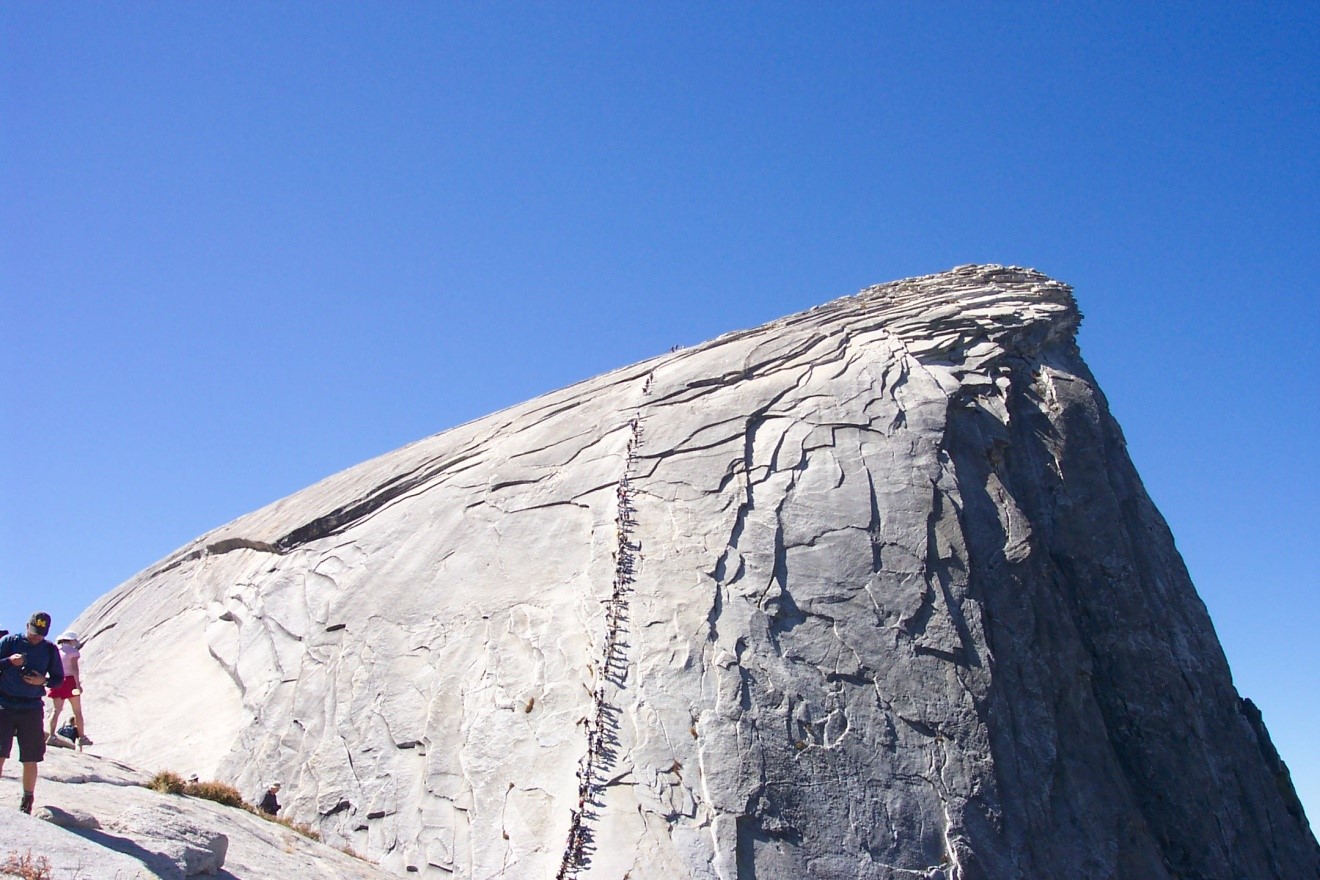
My knee continues to be a source of great pain as we reach the cables. At about 55 degrees, the ascent up the side of Half Dome would be impossible without the 800 or so foot span of steel cables to sue as hand grips. A pile of gloves reminds Jason and me to pull ours out of our packs. I believe that each one of the hundred or so people climbing the cables realizes that one false move would surely lead to their death, as the drop-off on either side would prove fatal.


After about 45 minutes of cable-climbing, we reach the top. I head for the edge where I can look down 4,000 feet, nearly a mile, to Yosemite Valley and our starting point. I truly feel as though I have accomplished something by climbing this peak, named for its geometric shape. From the highest point, I look over the edge of a sheer cliff into the valley, a mile below. Even after skydiving, this sends shivers down my spine.


We spend an hour or so at the top, reveling in our accomplishment and then begin the trip back. Coming down the cables is far more frightening than going up them, but we eventually make it. My need progressively gets worse until I decide to tie a ripped t-shirt around it. Jason fashions a walking stick for me along the way, but by the time we reach my truck, I can barely move my leg. I look back up and have no doubt that the pain only makes the experience mean that much more. In total, we hiked 18 miles with an elevation gain of 4,800 feet. This hike is not for the faint of heart, but has reminded me that willpower can overcome any obstacle.

Friday, September 24, 2004

Camping at Yosemite (Yosemite National Park, California)

My friend and fellow adventurer, Jason and I set our sights on Yosemite. We had both visited the National Park before, but were determined to conquer it on this campaign.

Before setting up our camp, we took a short hike through the Mariposa Grove of Giant Sequoias. Although I have seen the behemoths before in the Calaveras Grove, they never seem to disappoint. The magnitude of these specimens is comparable, but the grove has a unique feel to it.


Many trees catch our attention such as the Fallen Monarch, the Bachelor and Three Graces, which posses the placement of a certain famous painting based upon mythology of the Trojan War, and the California Tunnel Tree, which has been cut in such a way as to allow the trail to pass through its trunk. The patriarch of this grove, however, is the Grizzly Giant. Like something from Tolkien’s mythical Lothlorien, this tree rises from a semi-charred area to cast its giant shadow on the ground below. At a height of about 80 feet up, a large branch splits off from the trunk. This branch, however, has a diameter of nearly seven feet; larger than many giant redwoods . . . surreal!

After our short hike, we return to the Wawona Campsite to set up the tent and prepare dinner. While Jason collects some firewood, I prepare some skewers for our bratwurst. A good campfire is one of those precious memories that we cherish for a lifetime, and this is one of those. The crackling embers, the smoky taste to our meal, the incredibly warmth emanating from the flame all add to the experience.

Later that night, I venture out of the tent into a nearby clearing. A glance skyward reveals a majestic view of the stars, unparalleled in my travels. Their number appears to be endless, as if infinity has been demonstrated. After gazing for a short while longer, I return to the tent and enjoy a peaceful rest.