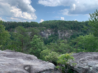
Cloudland Canyon in northwestern Georgia is arguable the most scenic state park in the state. It certainly is in my opinion. I've visited here a few times since moving to Georgia, but this weekend, I decided to host a campout complete with a couple of planned hikes for the Meetup group that I often hike with. I'm calling the event Cloudland Canyon Campstravaganza. Though many members expressed interest, we only had four others including myself show up. Ah well, since we have one of the large group sites reserved, we'll be able to spread out nicely.
After arriving at he park and checking in, I made my way to the walk-in campground to scout it out. Soon after others started arriving and we took some time to set up our tents and such. At approximately 3:15, we carpooled over to the other side of the canyon to begin our planned hike. We ended up a group of six in total. Two members wanted to do the hike, but not camp and one gentleman that signed up and paid for camping, didn't show up. It's a good group though and the first time here for a couple of the individuals. We take a few minutes to let them take in the sweeping views of the canyon before heading out on the West Rim Trail.
I tried to hike this trail on my first trip to this park, but ended up getting rained out and had to stop just a short distance into it. With clear skies and temperatures in the mid-nineties, I don't think that will be an issue today. The trails trail starts near the interpretive center and follows the eastern side of the canyon at first before dropping down above Cherokee falls and crossing over to to the western mesa. One of the hikers says something about this being as beautiful as the Grand Canyon, to which I strongly disagree, but it is quite majestic in its own right.
Along the way, we are afforded many great viewing areas and overlooks and the group is in awe, especially the 'first-timers'. With the high temperatures and very high humidity, I try to keep the pace relatively slow. We don't need anyone getting overheated. Soon, we reach the northern most point of the lollipop trail and continue through the woods along the wester side of the loop section before returning the way we came.
As four of us finish up, I notice that two have fallen behind and head back to check on them. They were getting hot and tired and had to rest for a bit, but they're both okay and we walk the final section to rejoin the others. I advise everyone to drink some cold water as we return to camp. The distance for this one is about 4.8 miles. Such a great hike to do this time of year and now, we'll head back to our campsite, get a fire going, enjoy some cold beer, and roast some hotdogs over the open fire. Life is good!


No comments:
Post a Comment