Today begins my four-day trek along the Inca Trail to Machu Picchu, the focus of my trip to Peru. This adventure has been a bucket list item for many years and I'm thankful to be in a place where I can begin exploring such places and experiences. The company I arranged the trip through, Follow Alice, generally takes eight guests on each trek, but in my case, the other seven people were traveling together and cancelled well after their permits were issued. As the permits to visit Machu Picchu are not transferrable and were completely sold out for these dates, Follow Alice was not able to fill the remaining spots, but agreed to proceed with the trip even though I was the lone guest. I'm sure they are loosing money on this overall trip, but as I had already made several personal arrangements to accommodate this trip, I was unable to reschedule. Besides, a private tour of one of the updated seven wonders of the world seems like a pretty good gig to me. At the very least, this little twist should make it interesting.
Awakening early in my expansive hotel room in Sacred Valley, I quickly shower and head over to the hotel restaurant to meet my guide, Mario, for breakfast. We make quick work of our plates of food and then grab our gear and head out to the van, where our driver and chef meet us. We have to drive another hour or so west to reach "kilometer 82", which is the official beginning of the Camino Inca.
Once we arrive, we meet up with the rest of the crew, which now includes a guide, a chef, and four porters. All of this attention just for me? This is going to feel strange. For anyone who regularly reads my blog, you know I backpack quite a bit and I'm used to carrying everything that I need to survive in the backcountry strapped to my back. For this trek, I will only carry a small day pack, while these porters carry a portable kitchen, bathroom, and large tents from one campsite to the next, with lunch stops in between. I really don't know how to feel about this, but I'm here now and have little choice, but to go with the flow.
After a quick gear check, Mario and I head to the check-in point, where he completes some paperwork related to our permits and I simply show the guard my passport. The guard waves us through and we proceed into a museum that highlights the natural and cultural wonders we are likely to see along the trail. Mario adds a lot of flavor to the displays, and obviously, has a lot of knowledge and experience with this region and trail.
Though I had thought we would return to the parking area and meet back up with the rest of the crew, we continue through another exit from the museum and before I even realize it, we have started the Inca Trail Trek.
Day 1
As we leave the museum, we notice some small wildfires burning above the museum. Apparently, fires have been a major problem in this part of the world as well and the steep cliffsides make them nigh impossible for firefighters to do much with them. Hopefully, this won't cause any problems along our route or for any of the locals.
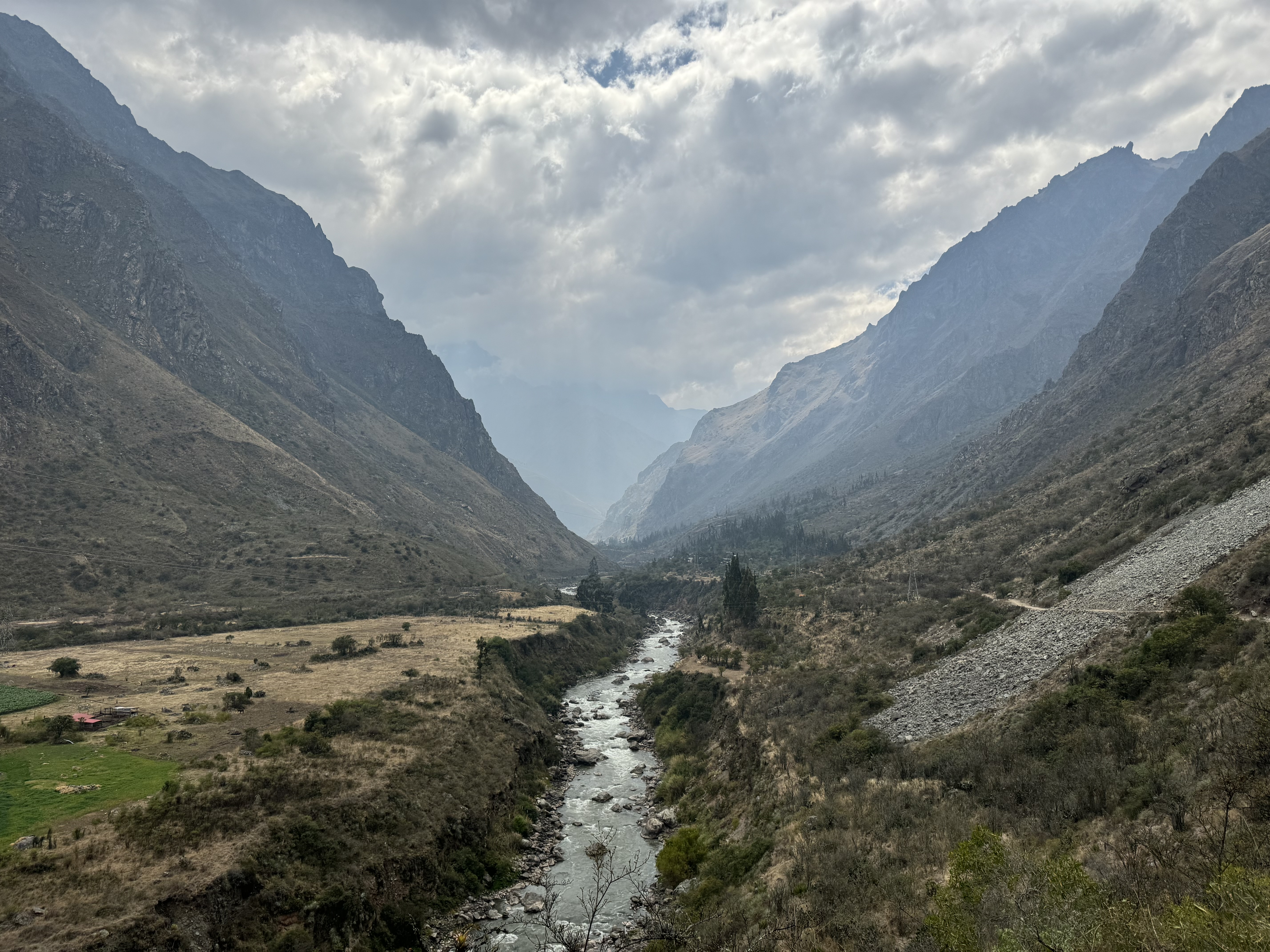
The trail wonders along and above the Urubamba River, which looks like it would be a fun one to kayak. This river is the creator of the Sacred Valley and provides a water source for many of the locals just as it did for the Inca five to six centuries ago. It's a pretty picturesque site, as the raging river rampages through the deep valley with high jagged mountain peaks above.
Almost immediately, we encounter our first Incan ruins. This set are the remains of a small supply point along a flat part of the rivers shoreline for those trekking from Cusco to Machu Picchu. The stonework is amazing and looks as though it were built yesterday. Only the missing thatched roofs give any indication that were are looking at ancient dwellings instead of modern ones.
Though only 500 permits are issued each day for hiking the Inca Trail, which includes guides, porters, and guests, it seems Mario knows every single person on this trail. He tells me that he has hiked the trail somewhere between four hundred and four hundred fifty times over his years as a guide. He seems to be something of a celebrity. As we walk, I begin to wonder where we will meet with the rest of our crew.
After hiking for only an hour or so, we stop at a small hut complex along the trail where others have gathered. All along this part of the trail, which has been relatively level so far, the homes of local people, descendants of the Inca, dot the landscape and each offers pay restrooms, soft drinks, and other amenities to hikers. This homes are little more than shacks and these people are obviously quite poor, but it is a testament to their strength that they can carve out a living in this place. It seems our crew has already erected the kitchen and lunch tents and have prepared a fantastic lunch for Mario and I. We are presented with garlic bread, pumpkin soup, a small salad, fried potatoes, and pan-fired chicken. To drink, the chef has made some very refreshing passion fruit juice. If this is the kind of meals I can expect during this trip, I'm going to gain a few pounds. Being treated like this, I can't help but feel like royalty, which is not a feeling I'm sure that I'm comfortable with. Everything is delicious and after consuming so much food, I feel like taking a nap, but there are miles to go and we had best get to it. Before we depart though, I ask Mario to introduce me to the rest of the crew. As each of them tells me their name and a little about themselves, Mario translates to English for me and I thank each of them in turn for their hard work thus far and to come.
While the crew packs up our facilities, Mario and I head up a hill above the village and into another set of Incan Ruins. This time, we are up close and person with the stone structures. He explains the likely purpose of each of the buildings and points out many of the well-engineered features. These structures were built to last a thousand years and by the looks of it, may well do that.
Nearing the end of the flat sections, we stop at a local market, where Mario converses with several of the locals, whom he obviously knows. While he chats, I rest on a bench with a covered thatch roof. We're here for maybe twenty minutes and during that time, I make it a point to absorb as much of the culture and my surroundings as I can. Unlike my previous international travels, this culture is quite different and I want to understand it as best as I can. Behind the buildings, I see a hunched old woman using trekking poles to try and climb a small ramp that leads to her home. The image burns in my brain and I can imagine this being a painting by some famous artist. Nearby, a large hen mothers a pair of her chicks, who struggle to climb up stone steps carved for human feet. A short time later, a small cat comes out of one of the dwellings with something in his mouth. As he approaches, he drops it and a small mouse begins to run away. The cat is having none of it though and bats at the mouse and picks it back up. For the next several minutes the cat and mouse continue to play like this. Well, play for the cat and obvious terror for the mouse. These are all just small things, but it's nice being able to spend the time to observe them and feel as part of the world around me.
After the rest, we begin a relentless climb up to our campsite for the night. We hike roughly a mile before Mario realizes that one of the campsite signs is missing. We're forced to turn around and walk back a short distance where we find our crew has already begun setting up the tents. It's nice to rest for a bit.

The campsites in this area are actually the terraced yards of local residents who apparently rent out their flat areas to trekkers. One of the porters brings some hand soap and a dish of warm water to the entrance of my extravagant tent and I wash up a little bit. At this elevation and with dusk quickly approaching, the temperature is dropping and so, I do it pretty quickly and then walk over to the dining tent, where hot tea awaits me. For dinner tonight, chef is service a vegetable soup and fried local trout with pasta and vegetables. For desert, a single strawberry sliced lengthwise and spread open with an edible flower garnish all sitting in a incredibly rich and delicious sweet purple-corn sauce. It's out of this world good, as I tell the chef.I was hoping to do some stargazing tonight, as my first night in the pseudo-backcountry of the southern hemisphere, but it's overcast and that won't be happening tonight. After dinner, I crawl into my tent and sleeping bag and doze off having finished the first (and easiest) day of the trek. We covered almost exactly 8 miles today.
Day 2
There were some light rains overnight, which I could hear bouncing off the top of my roomy tent. I'm sleeping in a North Face 3-person 4 season dome tent, which is gigantic for just one person, but it allows me to stretch out nicely. Knowing that we have a challenging day ahead of us, I had set my alarm about 30-minutes prior to the scheduled wake up call. After wandering out of the tent and finding a bush in the dark to relieve myself, I crawl back in and put on some fresh under layers and begin to pack. I can hear the porters and chef rustling around nearby in the kitchen.
Once packed, I crawl back out of the tent and walk over to the tent, where hot tea and breakfast await. Today, we're having fresh fruit (strawberries, mango, and some super-sweet apples), along with a dish of oatmeal. To top it off, chef brings in some pancakes with banana slices and chocolate syrup. I do my best, but I simply can't eat everything being prepared.
Finishing up our breakfast, Mario and I grab our packs and start heading up the steep ascent towards Dead Woman's Pass, the highest point on the trail. Along the way, he points out numerous interesting fauna and flora, including a few varieties of hummingbirds. These are much larger than the ones we have in the states though. Even the smallest species are twice the size of the tiny creatures we have in Georgia, while the larger species are the size of wren or cardinal. Interestingly, these humming birds tend to land much more often than the ones I'm familiar with back home. They hover by flapping their wings and impossible speeds, but do often land to get a better angle from which to drink the flower's sweet nectar.

The views are amazing this morning. Though, there is a bit of smoke from the wildfires and a cloud settled in here and there in these high peaks, the jagged mountains of this area dominate every view of the landscape, some of them reaching heights of seventeen or eighteen thousand feet. These are actually the tallest mountains I have ever seen and they are magnificent to behold.
After a grueling 3.4 miles of constant climbing, we finally reach Dead Woman's Pass the highest point on the Inca Trail at 13,780 feet. The climb to get here was slow and included several thousand stone steps. I've been taking Diamox the last few days to help with the elevation, but even with this and a few days to acclimate, I quickly get out of breath working so hard to climb the steep 40° incline to reach this point. Luckily, there are no signs of HAPE or HACE. I just need a minute here and there to catch my breath. Mario is very understanding.
It's cold and windy up here and I'm forced to put on more layers, while we take a break and enjoy the views. Looking down at the path we will soon be following, a cloud has parked and hides much of the landscape beyond, but what little can I see looks amazing. At least we will be going downhill for a while.
I thought downhill would be great, but some of these steps are incredibly steep and I can already feel my knees crying. I do my best to put some of the impact on my shoulders and arms by using my hiking poles, but there are just so many steps. Eventually, we reach our campsite for the evening, which is only about 1.4 miles beyond the pass. Our total distance to this point is about 12.8 miles, but it seems like so much further. In my normal life, hiking 12.8 miles is absolutely nothing and I do this regularly, but combined with the thin air at this elevation and the absolutely relentless ascents and descents on these steep stone stair cases of the Inca, I'm exhausted.

As we arrive at our campsite, lunch has been prepared and starts with an absolutely delicious purple corn drink. I'm told it consists of steeping purple corn on the cob with cinnamon and anise, and then adding sugar to sweeten the brew. I put a way two or three cups of this nectar of the gods before forcing myself to stop. For the meal, we enjoy avocado with chicken and vegetables, quinoa soup, and beef with olives, French fries, and more vegetables. All of it is crazy good.After lunch, I retreat to my tent and nap for a couple of hours. As dusk approaches, I can hear noise emanating from the kitchen tent and crawl out to see what's going on. It's simply dinner being prepared. I'm not sure how I'm supposed to eat more food at this point, but knowing we have a lot of miles to cover tomorrow, I'll do my best.
Though only a couple of hours have passed, chef has prepared another four-course meal of impeccable quality. We start with a pineapple pastry and tea. This is followed by some sort of noodle soup. For the main course, we enjoy vegetable-stuffed chicken breasts with another one of the three-thousand potato varieties (mashed with butter this time) and green beans. For desert, a intricately carved pear in a slightly different sweetened purple corn sauce. All of it is absolutely delicious, but my stomach has limits and I'm unable to finish everything. I explain this to the chef so as not to offend him by sending food back uneaten.
After dinner and quick visit to a nearby bush, I turn in for the night. We're sleeping at nearly 12,000 feet and tonight will be the coldest on the journey. I've got great gear though and shouldn't be bothered by it. Off I go to dreamland.
Day 3
Waking early once again, crawl out of my tent. It's definitely colder this morning than yesterday, but my tent has good insulation and I'm warm enough to pack and wash up a bit. Exiting my tent, I wander over to find that bush again and notice that the skies are clear this morning. After addressing the current need, I take a few minutes to stargaze. Most of the stars and potential constellations I see are foreign to me, but Orion stand out as an obvious old friend.
We're planning to get a pretty early start today, as it will be another tough one with twice yesterday's mileage and nearly as much elevation gain and loss. To fuel us up for today's hard work, chef prepares wonderful breakfast consisting of fruit, scrambled eggs, steamed broccoli, and some kind of pork sausage that is a cross between bacon and a hot dog. It's all very tasty and I eat as much as I can.
As the sun begins to rise, Mario and I hit the trail, while the crew begins to pack everything up and head to our lunch spot. The next section is steeply uphill, perhaps the steepest section I've ever climbed. Over the course of an hour and forty minutes, we only manage to traverse a single mile, so steep is are the steps here.
Soon, we reach the ruins of Sayacmarca, which likely served as a military outpost and overlooks the valley below. To enter the fortress though, we must climb a couple of hundred narrow steps at an approximately 60° angle. This is precarious with the threat of plummeting into the valley far below forefront in my mind. We make it though and I'm glad, as this ruin is amazing.

It's easy to see the military genius in placing a watchtower high above the trail below, but the planning and engineering that went into it's construction is awe-inspiring. A small mountain spring feeds a complex canal system that feeds public fountains throughout the facility. Additionally, some sections were only accessible to higher ranking individuals. To ensure this discipline was maintained complex locks were built into the stone carvings at various entrance ways. These people were far ahead of their time. As we've traveled the trail, I'm forced to wonder what they might have accomplished had the Spanish not invaded and destroyed their culture. I envision something like the mythical Wakanda from comic book lore, with the entirety of the local valleys all terraced. It might have been something spectacular.
As we descend the steps, I manage to get some sunscreen in my eye. This is doubly troubling, as I'm forced to close one eye and ruin my depth perception while coming back down those super steep and precarious steps that we had to climb to get up here in the first place. I do make it down though without falling . . . thankfully. Nearby, a rarely-seen Peruvian Tree Rat bounces up and down on some tree limbs.
From here, we continue a bit further and past more ruins to our lunch spot, which is on the second highest pass of the trail. As I entire camp, one of the porters hands me a glass of sweetened lime juice, which hits the spot. For or midday meal, we are presented with a beautiful tempura zucchini and vegetable fritter, yellow potato soup (which Mario claims is his favorite), another beef dish, fried potatoes and quinoa with vegetables. I'm so full, lol.This is a popular stopping point and many other groups have stopped here for lunch. I chat with a couple of groups that we've been hopscotching with along the trail. All very friendly people and seemingly in the same stupored awe I'm feeling at being in this place.
Smoke from the wildfires has filled the valley ahead of us and it somewhat diminishes the views, but there is still a lot to see. On the small peak just above camp, several trekkers admire some llama that have wandered into camp. It's time to pack up and hit the trail again though, we still have a few miles to cover today.Along the way, we pass through a couple of stepped cave passages carved into the rock. On in particular seems pretty dangerous as it is very dark, very steep, and with very narrow steps. Again though, we make it through without incident. The trail includes a huge amount of descending steps and my knees are begging for mercy at some points.
Reaching the gigantic ruin of Intipata, we take time to rest and explore the terraced village. This ruin is absolutely huge and probably covers the area of a two football fields, though on a steep hillside that has been engineered with numerous terraces. We find a spot to rest on the soft grasses of one of the terraces and I mingle with one of the other groups while we all admire the site. This group includes three young ladies who went to high school together in Milwaukee, but have sense moved to different parts of the country. I can relate, as I have some great friends like this as well and we occasionally try to get together.
Departing the ruin, our campsite is just ahead and the porters have already got everything set up. Mario explains that this campsite actually has showers, but no heated water. I know I'm pretty stinky by this point, given how much I've been sweating on these uphill sections and so, I decide to venture in and attempt a cold shower. He's right, it's freezing cold. I do my best to lather up and then just go under the water for the quickest moment to wash the soap off. I somehow manage to mostly clean myself and I feel a lot better, though I'm freezing.

Between the shower and the campsite some very colorful mosses catch my eye and I'm forced to take a picture as I return to camp for the evening meal. For dinner, we're served an interesting savory French toast that includes shredded carrots and zucchini, a sort of vegetable fried rice, asparagus soup, and a chicken drumstick that has had the meat removed, mixed with potatoes and vegetables, and then reapplied to the bone and lightly fried. It's really good. For desert, which will be the finale of our trip meals, chef has prepared prickly pear with some sort of sweet pasta in a cream sauce. It's really good.
After dinner, we go through the traditional tipping ceremony. The guide organization designs this to make the giving of gratuities easy on guests. As I chat with the crew (with Mario helping me translate), I express my appreciation for all of their incredibly hard work and to chef for his amazing creations. I put a little something in an envelop for each of them and distribute accordingly. I explain that while I know they will not be receiving as much of a tip as they deserve and would get if there were eight guests on the trip, I have tried to be very generous. These guys are troopers and have been lugging 50-60 pound packs up the same trials that I've been struggling with. Granted they live at this elevation and do this all of the time, but that doesn't mean it's easy work. They deserve my appreciation and most certainly have my respect.
Turning in for the night, I look at my mileage for the day and realize we've covered about seven hard miles today, bringing our trail total to 19.7. I think I lost GPS signal while in one of the caves and so the distance may be slightly greater, but we'll with it.
Day 4
Rising at 3:00 AM today in order to reach Machu Picchu as soon as possible and before all of the bussed-in tourists arrive, Mario and I eat a quick breakfast of toast and a hard-boiled egg. It was much warmer last night due to the lower elevation. I throw my pack on and we say our goodbyes to the crew. This is the last time I will see them as they will take a different route to exit the trail.
Mario and I walk through the campsites and arrive at the checkpoint, which doesn't open until 5:30 AM (about an hour from now), but numerous groups have already arrived. It's cold sitting here waiting to check-in and I put my puffy coat on and find a rock on which to snooze a little bit. Right on the dot, the lights come on and hikers begin to line up and pull out their passports. We all work our way through the checkpoint in turn and then start the fairly easy trail towards the famous Inca mountain retreat.
Soon, we arrive at the Sun Gate, which provides some stunning views. Again, reaching the top requires a climb up some very steep steps, but seeing Machu Picchu for the very first time in the distance somehow energizes me and I push my way to the top. Smoke lingers in the valley, but it's thinned out enough to allow some decent pictures. Mario and I continue the rest of the way to the ancient city, where he will provide me with an extremely informative tour of the ruins. I'll write about all of that and the city as a whole in a separate post. For now, I'm just glad to have completed this incredibly difficult trail. Our total distance was only about 22.8 miles, but included over 8,300 feet of ascent and nearly 8,800 feet of descent. It also included somewhere around 7,000 stone steps from what I've read online. It truly has been an epic adventure and I look forward to exploring the masterpiece of the Inca culture over the next couple of hours.