I've tried a couple of times in the past to visit Grandfather Mountain, but in all cases, inclement weather has put a damper on the trip. We did get some rain yesterday afternoon, but I'm hopeful that this won't interfere with my plans too much. Grandfather Mountain was once thought (by colonists) to be the tallest mountain east of the Mississippi. It includes four major peaks, the highest of which is 5,946 feet. Later it was determined that the nearby Mount Mitchell actually holds this distinction. However, Grandfather Mountain is still a draw because of its ruggedness and prominence.
After entering the park, I head to the parking area. Along the way, I find a pull-off that provides a great view of the two highest peaks and stop for a couple of pictures. Continuing up the winding road, a traffic director motions me into one of the parking areas and explains how to get to the "Mile-high Swinging Bridge" and the other trail system.
I park my car, grab my pack and start formulating a plan for the day. I had some ideas of what I wanted to do here, but with time constraints and the somewhat wet ground from yesterdays downpour, I'm rethinking the plan. Originally, I was going to hike the 10.5 mile profile trail. However, that plan required starting around 7:30 AM. At the time I made the plan, I didn't realize the park didn't open until 9:00 AM.
To start, I decide to hike the half-mile or so up to the swinging bridge and then possibly continue on along the Grandfather Trail, which visits all of the peaks. I'll wing it. The short trail from the parking area is fairly steep and has a lot of stones and roots to navigate, but it's generally pretty easy. Arriving at the top, another parking lot leads to stairs up to the swinging bridge, which spans 228-feet above an 80-foot gorge separating two of the mountains smaller peaks. I cross over it without any issues. Though I'm not a huge fan of heights, the bridge seems pretty stable and only sways slightly with six or so people on it. Near the middle, I line is painted indicating the 1-mile elevation mark.
Reaching the other side, I start a short rock-scramble up to a view point. There area a number of people up here already and after stopping to look around, I can see why. The view here is absolutely spectacular. The bluish-green sea that is Appalachia spreads out in all directions from me. It's actually pretty breathtaking.
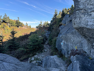
Crossing back over the bridge, I decide to continue with my plan to hike the Grandfather Trail I know this one is pretty intense and even requires a self-issued permit to hike. I'm a bit concerned about wet and slippery trail conditions, but I'll judge it as a I go. I toss my scrambling gloves on as I depart the upper parking lot and climb up the rugged first part of the trail through granite boulders.
The first really big obstacle that I have to overcome is climbing a wet granite wall of about forty feet and at a roughly 45° angle. The park has installed a knotted steel cable to assist and I carefully make my way up it, second-guessing myself along the way. I reach the top though and decide to continue a little further.
The climb back down the cable is an adventure, but again, I make it without any problems and eventually hit the Grandfather Extension Trail, which leads to the lot where I left my car. I've only hiked about 2.5 miles and I would love to do more, but other adventures await and I'm just not convinced that this one is safe with the muddy, wet conditions on the rugged trail. It was a lot of fun though and the views are some of the best in this part of the country.


No comments:
Post a Comment